Item Details Content statement PID nyhs:treasures NYHS Identifier Library Collection Member of New-York Historical Society Digital Collections Genre archives (groupings) broadsides (notices) drawings (visual works) ephemera (general object genre) manuscripts (documents) maps (documents) newspapers photographs printed ephemera prints (visual works) rare books views (visual works) Owning Institution New-York Historical Society Publisher New-York Historical Society Type Text Subject (Topical) Libraries--New York (State)--New York--Archives Subject (Name) New-York Historical Society. Library--Archives Contributor New-York Historical Society. Library Date Created 1600 to 1950
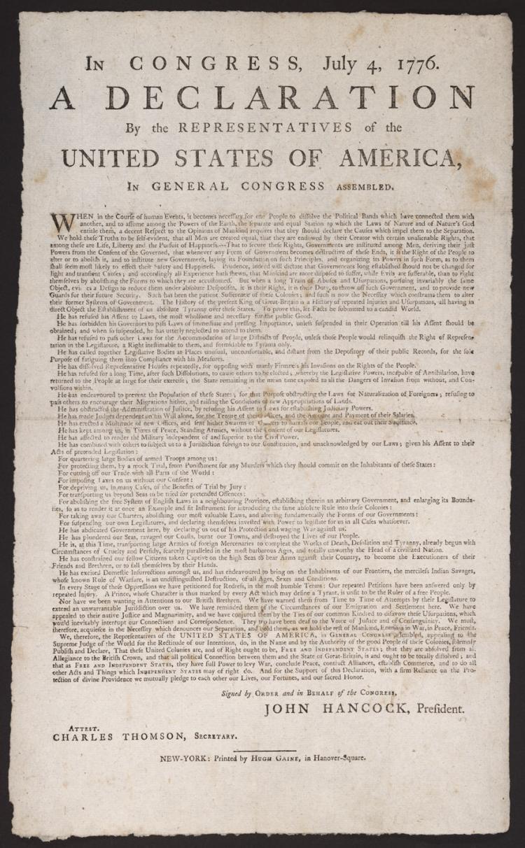
Image Text 2 Items In Congress, July 4, 1776. : A declaration by the representatives of the United States of America, in general Congress assembled. The Hugh Gaine printing of the Declaration of Independence. "Signed by order and in behalf of the Congress- John Hancock- president. Attest. Charles Thomson- secretary." Watermark: Strassburg bend and lily over "GR." New-York Historical copy presented by Lucius Wilmerding. Cf. NYHS Quarterly 32 (1948). References: Bristol B4403; Shipton & Mooney- 43203; Walsh- M.J. "Contemporary Broadside Editions of the Declaration of Independence." Harvard Library Bulletin 3 (1949): 31-43- 4. View Item
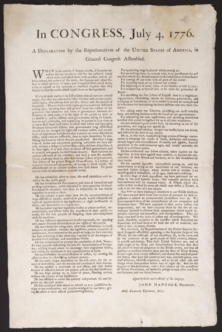
Image Text 2 Items In Congress, July 4, 1776. : A declaration by the representatives of the United States of America, in general Congress assembled. The Declaration of Independence- place of publication and printer unknown. "Signed by order and in behalf of the Congress- John Hancock- president. Attest. Charles Thomson- sec'ry." Text printed in two columns- 70 lines in first. Watermark: A Rogge. References: Bristol B4404; Shipton & Mooney- 43196; Walsh- M.J. "Contemporary Broadside Editions of the Declaration of Independence." Harvard Library Bulletin 3 (1949): 31-43- 5. View Item
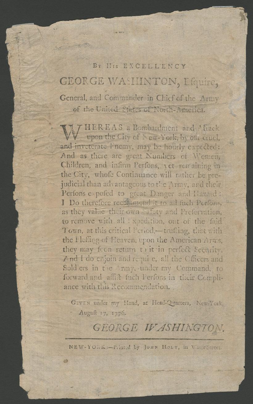
Text By His Excellency George Washinton [sic], Esquire, general, and commander in chief of the army of the United States of North-America. : Whereas a bombardment and attack upon the city of New-York ... may be hourly expected: and as there are great numbers o Signed and dated: Given under my hand- at head-quarters- New-York- August 17- 1776. George Washington. References: Evans- 15153. View Item
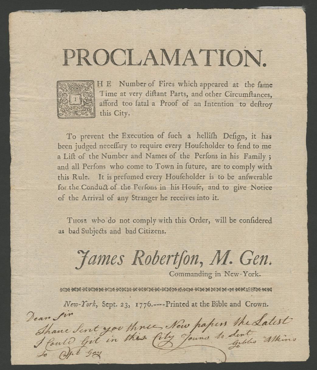
Text Proclamation. The number of fires which have appeared at the same time at very distant parts, : and other circumstances, afford too fatal a proof of an intention to destroy this city ... require every householder to send me a list of the number and names Signed: James Robertson- m. gen. Commanding in New-York. Mortized initial- type ornament rule. The initial and address are of Hugh Gaine- who was in Newark at this time. His press in New York was not supervised by Ambrose Serle until Sept. 30. Cf. Ford. Watermark (cropped): IV. New-York Historical copy with holograph note: Dear Sir- I have sent you three new papers the latest I could get in this city. Yours to [lent?] Gibbs Atkins. To Capt. Gay. References: Reilly- E.C. Colonial printers' ornaments 367; Ford- P.L. Journals of Hugh Gaine- p. 56-57. View Item
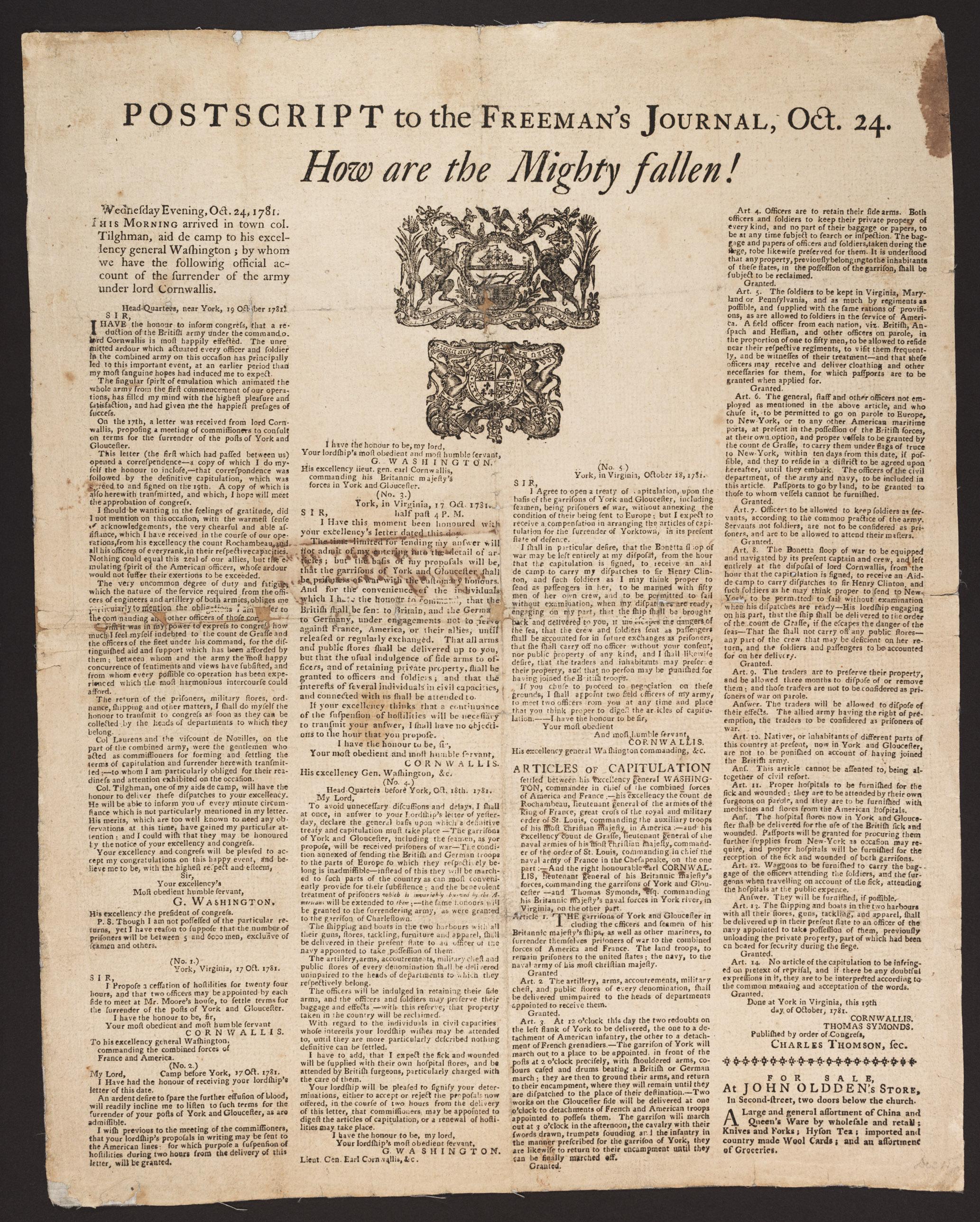
Text Postscript to the Freeman's journal, Oct. 24. : How are the mighty fallen! Wednesday evening, Oct. 24. This morning arrived in town col. Tilghman, aid de camp to His Excellency general Washington; by whom we have the following official account of the surr The Freeman's journal was printed in Philadelphia by Francis Bailey. Includes Washington's letter to Congress- dated 19th Oct.- 1781- followed by the correspondence between Washington and Cornwallis- dated 17-18th Oct.- and "Articles of capitulation ... Done at York in Virginia- this 19th day of October- 1781. Cornwallis. Thomas Symonds. Published by order of Congress- Charles Thomson- sec." Advertisement for John Oldden's store- Second Street- Philadelphia- at end. New-York Historical copy damaged along creases- slightly affecting text and illustration. View Item
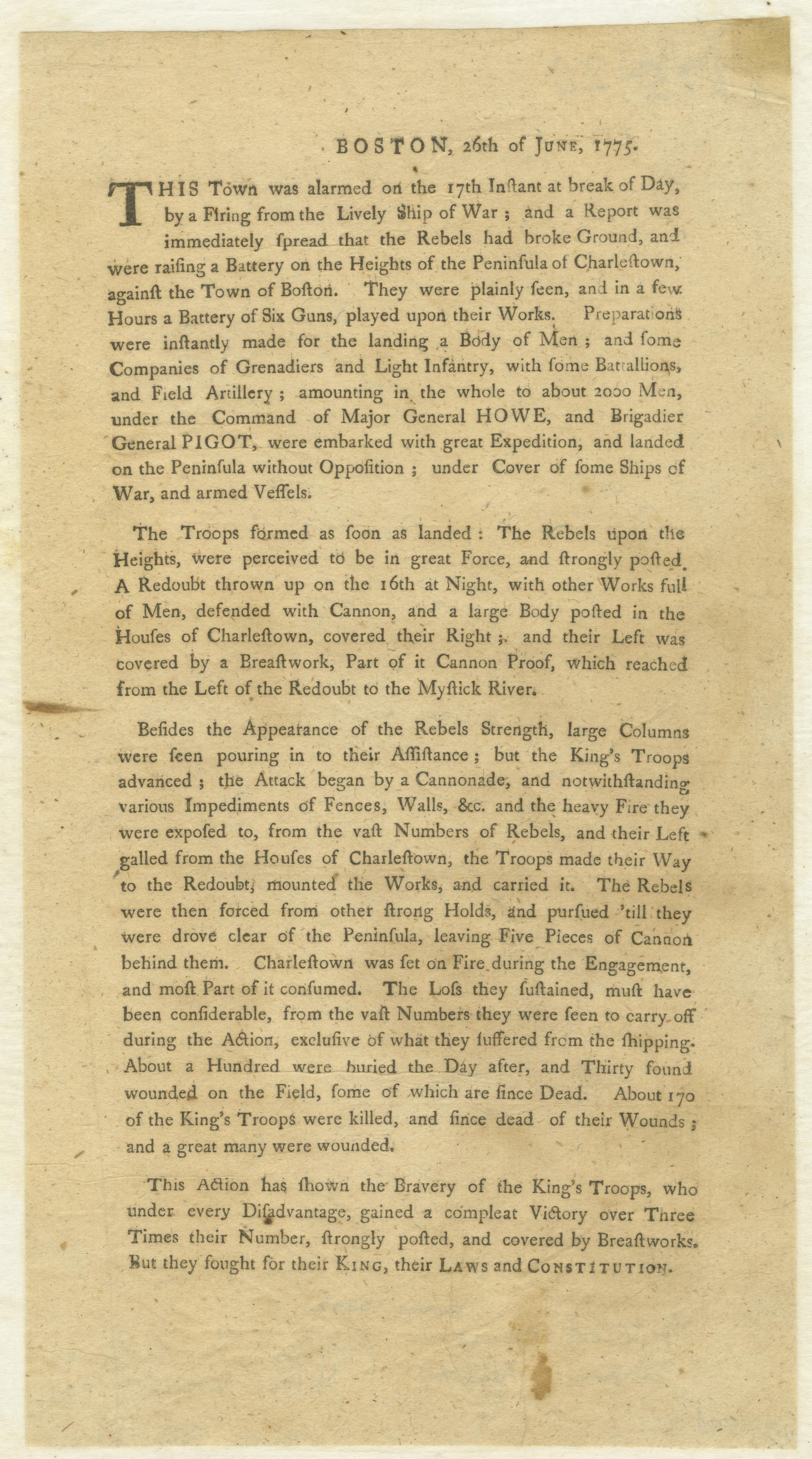
Text Boston, 26th of June, 1775. : This town was alarmed on the 17th instant at break of day, by a firing from the Lively ship of war; and a report was immediately spread that the rebels had broke ground, and were raising a battery on the heights of the penins This broadside contains the first printed account of the Battle of Bunker Hill. It was evidently written immediately after the famous engagement by British officers who greatly underestimated English losses and exaggerated the strength of the American forces. Imprint supplied by Evans. References: Evans 13842; Ford- W.C. Broadsides- 1801; ESTC W9549. View Item
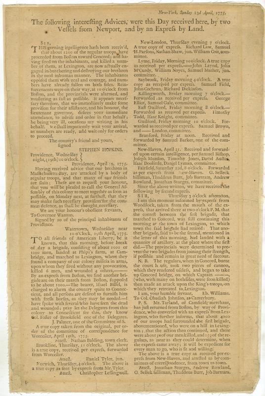
Text New-York, Sunday 23d April, 1775. The following interesting advices, were this day received here, : by two vessels from Newport, and by an express by land The first news to reach New York concerning the battles at Lexington and Concord. References: Evans 14337. View Item
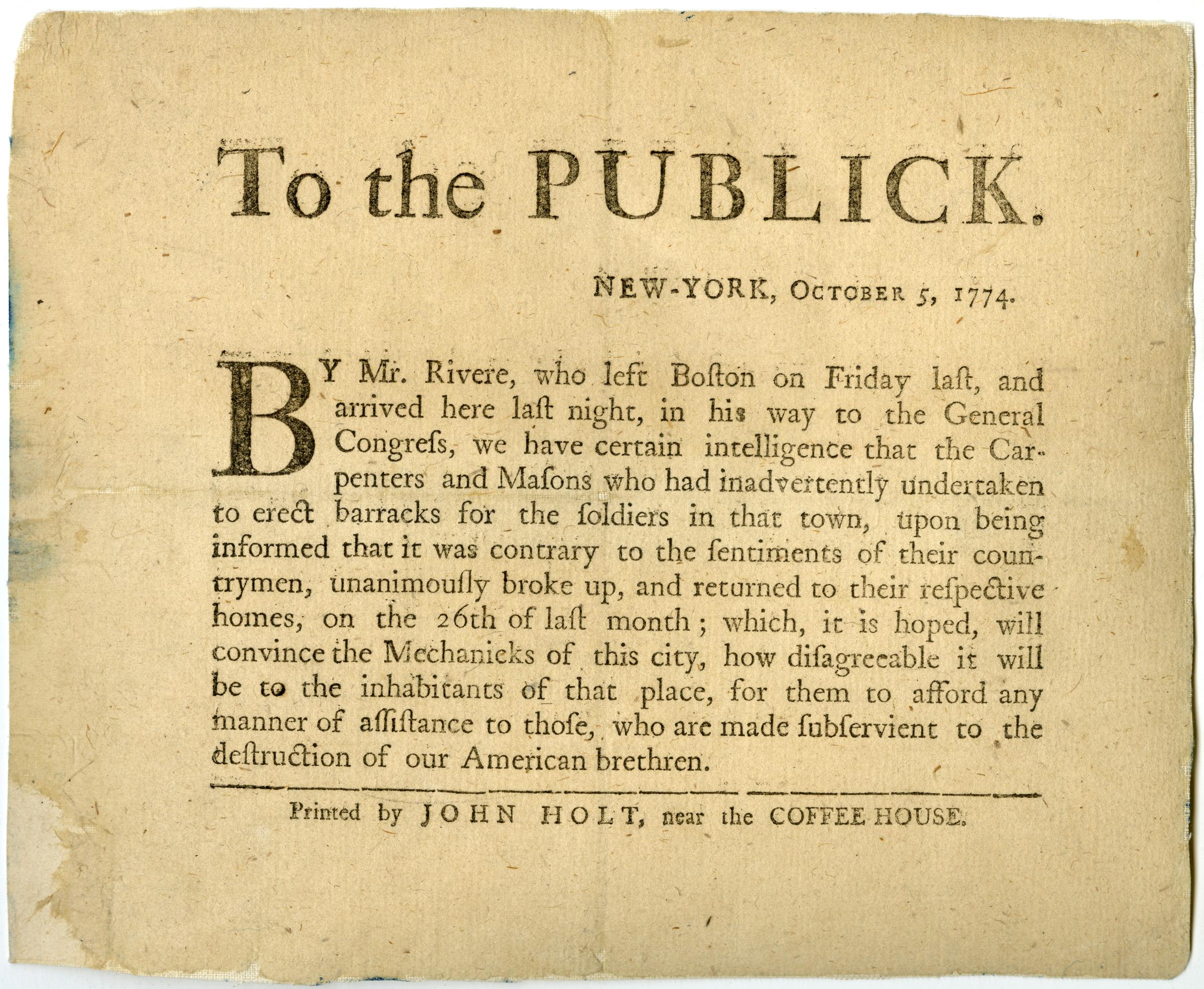
Text To the publick. New-York, October 5, 1774. : By Mr. Rivere [i.e. Revere], who left Boston on Friday last ... we have certain intelligence that the carpenters and masons who had inadvertently undertaken to erect barracks for the soldiers in that town ... u Broadside announcing Paul Revere's ride through New York and encouraging the mechanics of New York not to participate in the construction of barracks for the British soldiery. References: Evans 13674. View Item
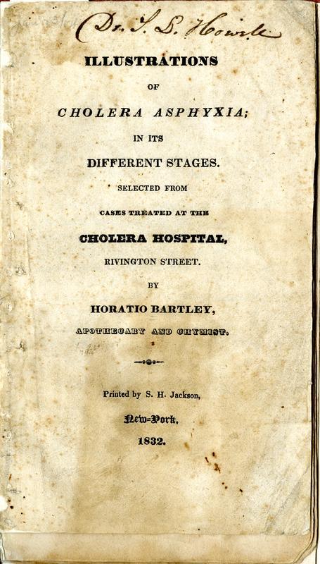
Image Text 13 Items Illustrations of cholera asphyxia; in its different stages Selected from cases treated at the Cholera Hospital, Rivington Street. / By Horatio Bartley, apothecary and chymist [sic] Lithographic illustrations of cholera victims, annotated in pencil with the outcome of their illness. New-York Historical copy signed on the title page: Dr. S.L. Howell. Annotated by Dr. Howell. The lithographs are hand colored. View Item
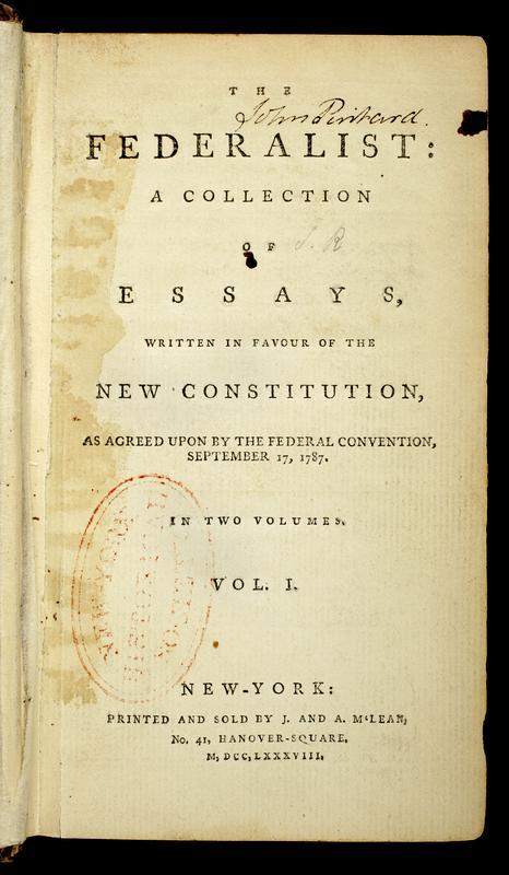
Image Text 6 Items The Federalist: : a collection of essays, written in favour of the new Constitution, as agreed upon by the Federal Convention, September 17, 1787. : In two volumes. : Vol. I[-II] Title page, introduction, table of contents, and first page of John Pintard's copy of the first complete edition of the Federalist published in book form. The Federalist is included on nearly every list of influential books because it is due, at least in part, to this work that the United States Constitution was ratified. Its 85 essays were first published in newspapers and then issued in two volumes. Written by Alexander Hamilton, James Madison, and John Jay. Each essay signed: Publius. View Item
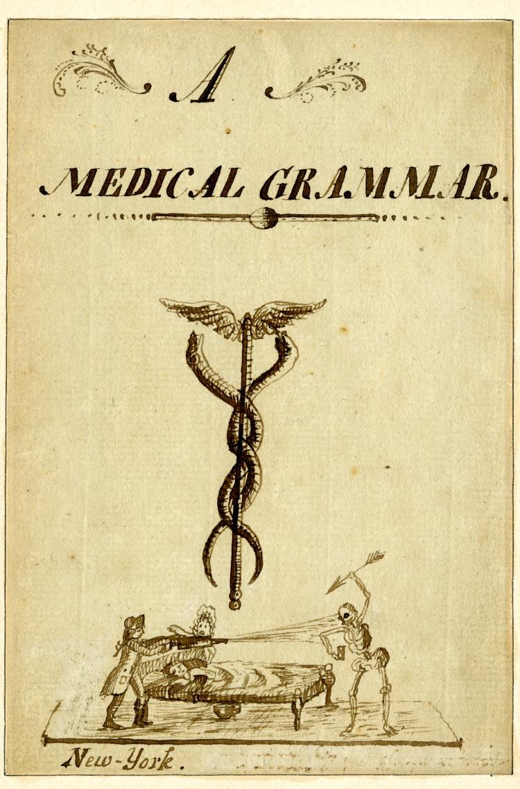
Image Text 31 Items Alexander Anderson, A medical grammar, circa 1795 Alexander Anderson was a New York City physician and illustrator. He was the first physician at Bellevue Hospital, established in 1795 to treat patients in a yellow fever epidemic, but he is best known as one of the first American wood engravers. This is a manuscript with three pen and ink drawings done by Dr. Anderson when he was 20 years old, relating to his medical practice and his interest in engraving. View Item
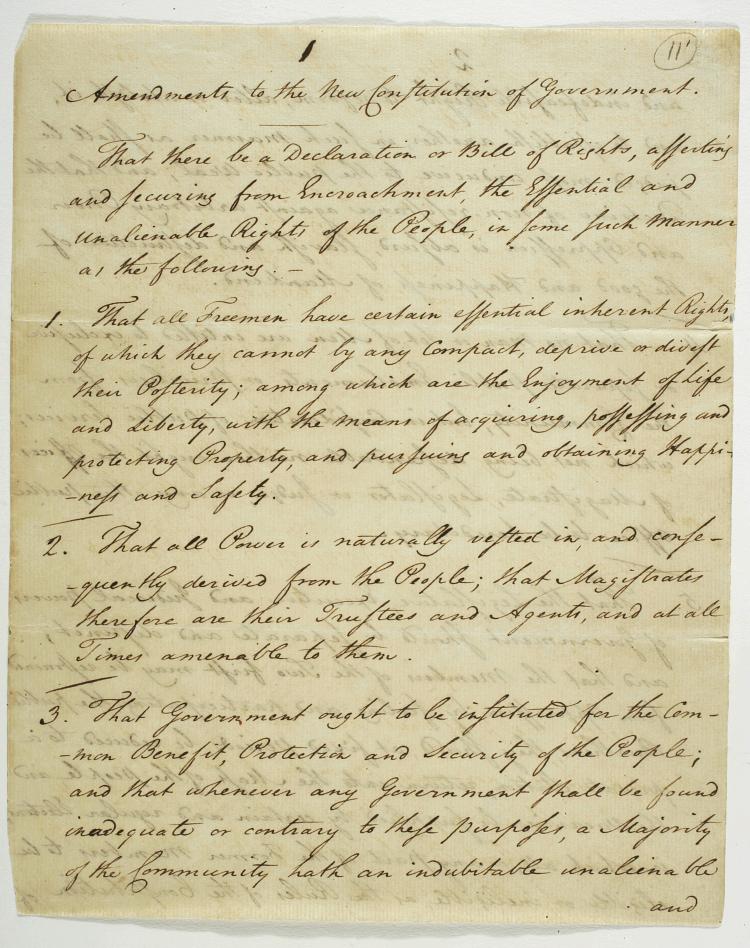
Image Text 12 Items George Mason, Amendments to the new constitution of government, June 9, 1788 View Item
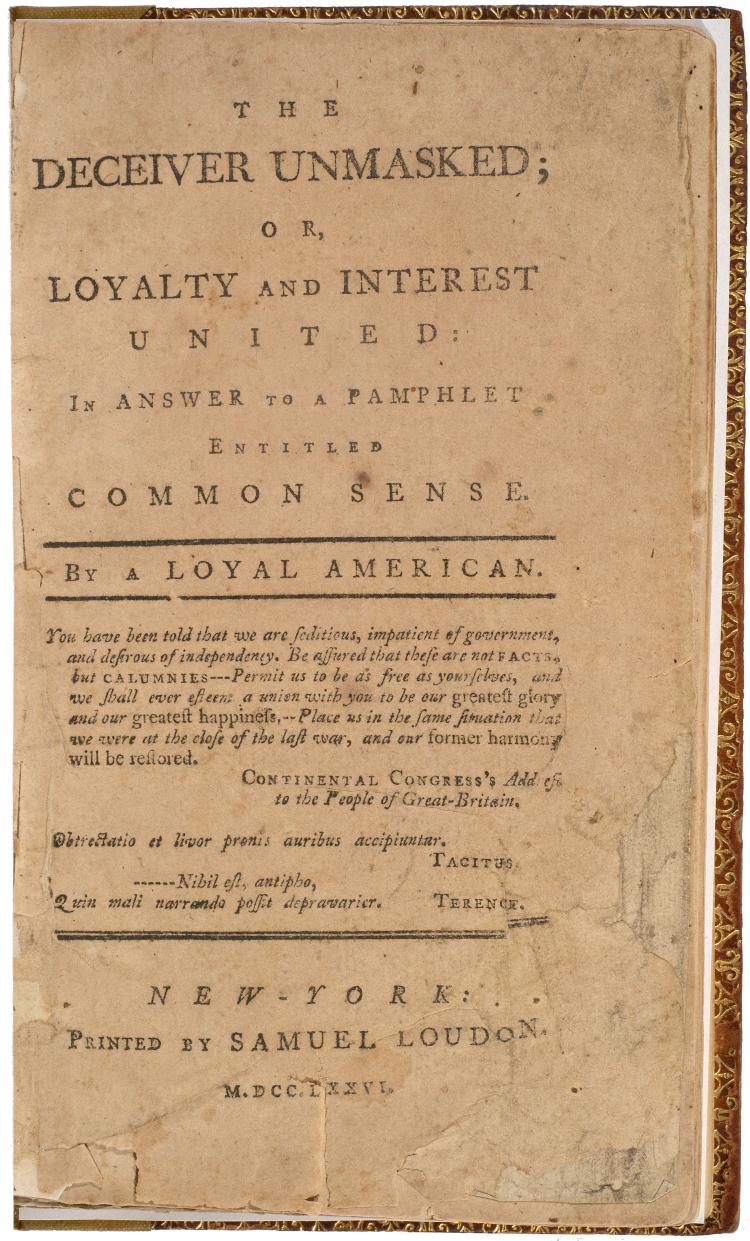
Image Text 7 Items The deceiver unmasked; or, Loyalty and interest united: : in answer to a pamphlet entitled Common sense. / By a loyal American Title page and preface of a rebuttal to Thomas Paine's Common sense by a New York loyalist clergyman. Before it could be distributed, the printer's stock was burned by a mob; a notation on this copy says it was salvaged from the fire. Also published in Philadelphia under the title: The true interest of America impartially stated. Preface dated: February 16, 1776. Type ornament head and tail-pieces. Signatures: A-G⁶ H² (H2 verso blank). References: Bristol 4238; Adams, T. R. Amer. pamphlets, 219a; ESTC W8906. View Item
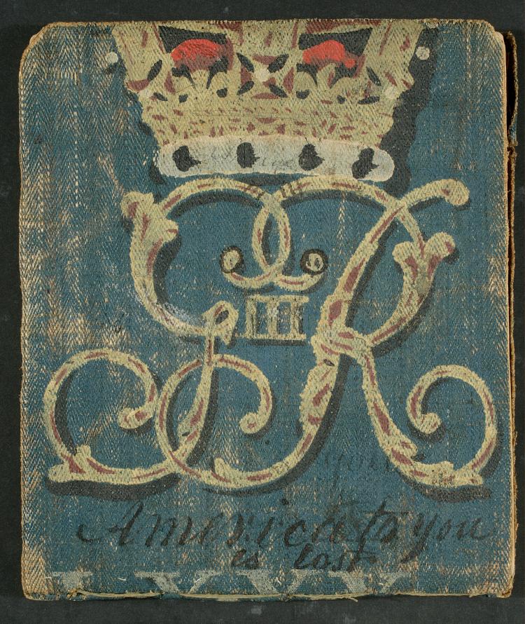
Image Text 2 Items Philip Van Cortlandt's Second New York Regiment of 1777 orderly books, 1779-1783, undated. Orderly book for September 26-October 30, 1781, cover and paste-down endpaper Cover and paste-down endpaper of orderly book for September 26-October 30, 1781 kept by Barnardus Swartwout Jr., bound in canvas painted with the monogram of George III and part of the Roman numeral LXXX, indicating it previously belonged to the British 80th Regiment. The words "America to you is lost" are painted underneath; a note inside the front cover reads "Captured Lord Cornwallis & the cover of this book." The 2nd New York Regiment, under the command of Colonel Philip Van Cortlandt, was organized in late 1776 and discharged in November 1783. View Item
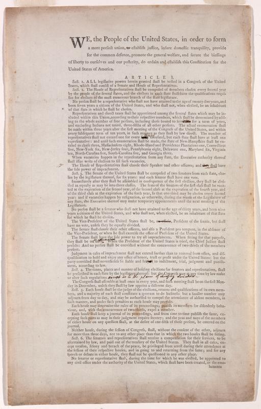
Image Text 4 Items We the people of the United States, in order to form a more perfect union, to establish justice, insure domestic tranquility, provide for the common defence, promote the general welfare, and secure the blessings of liberty to ourselves and our posterity, Caption title. William Livingston's copy of the second draft of the United States Constitution, with his manuscript annotations showing changes that appear in the final version. William Livingston was Governor of New Jersey from 1776 to 1790. He joined the New Jersey Delegation to the 1787 Constitutional Convention in Philadelphia, and was one of the signers of the Constitution. View Item
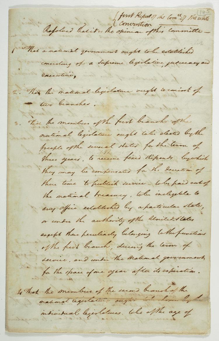
Image Text 7 Items Rufus King, First report of the Committee of the Whole Convention, 1787 Rufus King's notes of the closed proceedings of the Constitutional Convention are the only record, other than a much later version by his friend James Madison, of arguments brought to the convention floor. View Item
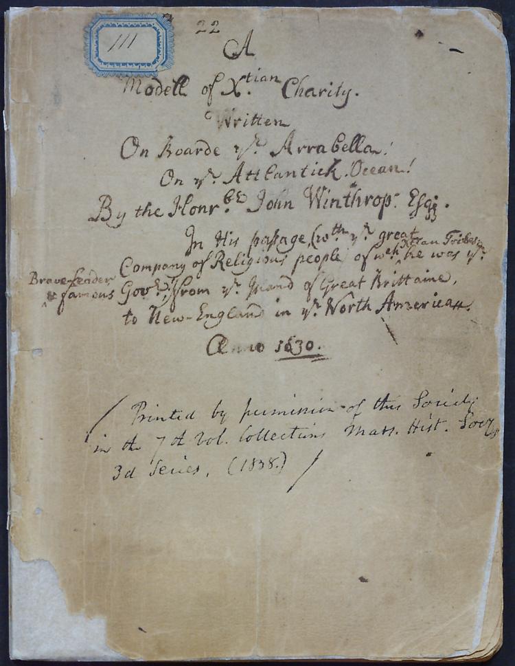
Image Text 45 Items John Winthrop's A modell of Christian charity, written on boarde the Arrabella, on the Attlantick Ocean, 1630 Manuscript copy, probably contemporary, of John Winthrop's sermon 'A Modell of Christian Charity,' 1630. Gift of Francis B. Winthrop, 1809. View Item
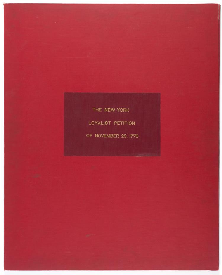
Image Text 5 Items Petition of 547 loyalists from New York City, November 28, 1776 Also known as the "Loyalist declaration of dependence", this was the second petition addressed to the Royal Commissioners Richard and William Howe from loyalists seeking special protection under British occupation. Their first petition, for the suspension of martial law, went unanswered; in this second, insisting that they had risked their lives and fortunes opposing "the most unnatural, unprovoked rebellion, that ever disgraced the annals of time", the loyalists sought only "some level of distinction" from the "inhabitants in general". View Item
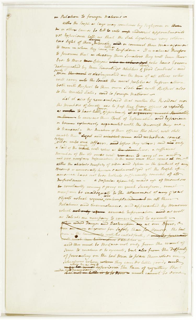
Image Text 8 Items John Jay's In relation to foreign nations, circa 1788 Draft in John Jay's hand of Federalist Number 64, originally published on March 5, 1788 in the Independent Journal. It bore the number 63 in the newspaper version, but was renumbered 64 in the first collected edition, published 22 March 1788. Comparison with the published version shows little change in the substance of the argument for the constitutional provisions for senatorial approval of treaties. Changes in organization and wording are substantial. View Item
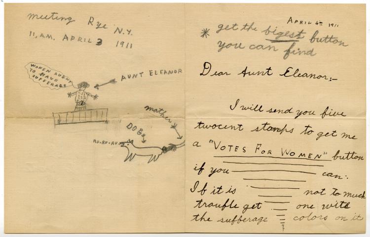
Image Text 2 Items Letter to suffragist Eleanor C. Erving from her niece Bertie, April 4, 1911 Letter requests a "votes for women" pin, with the "sufferage [sic] colors". View Item
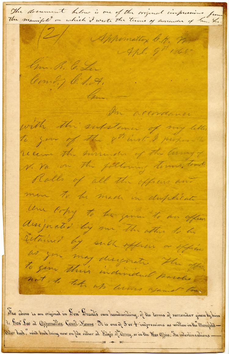
Image Text 2 Items Ulysses S. Grant letter to Robert E. Lee, Appomattox Court House, April 9, 1865 The terms of surrender of General Robert E. Lee's army at Appomattox Court House, April 9, 1865. One of the original impressions from the manifold on which General U.S. Grant wrote the terms of surrender, with interlinear revisions by Ely S. Parker, a Tonawanda Seneca man who had been Grant's military secretary since 1863. Parker's inscription below reads: "The above is an original in Gen. Grant's own handwriting of the terms of surrender given by him to Gen. Lee at Appomattox Court House. View Item
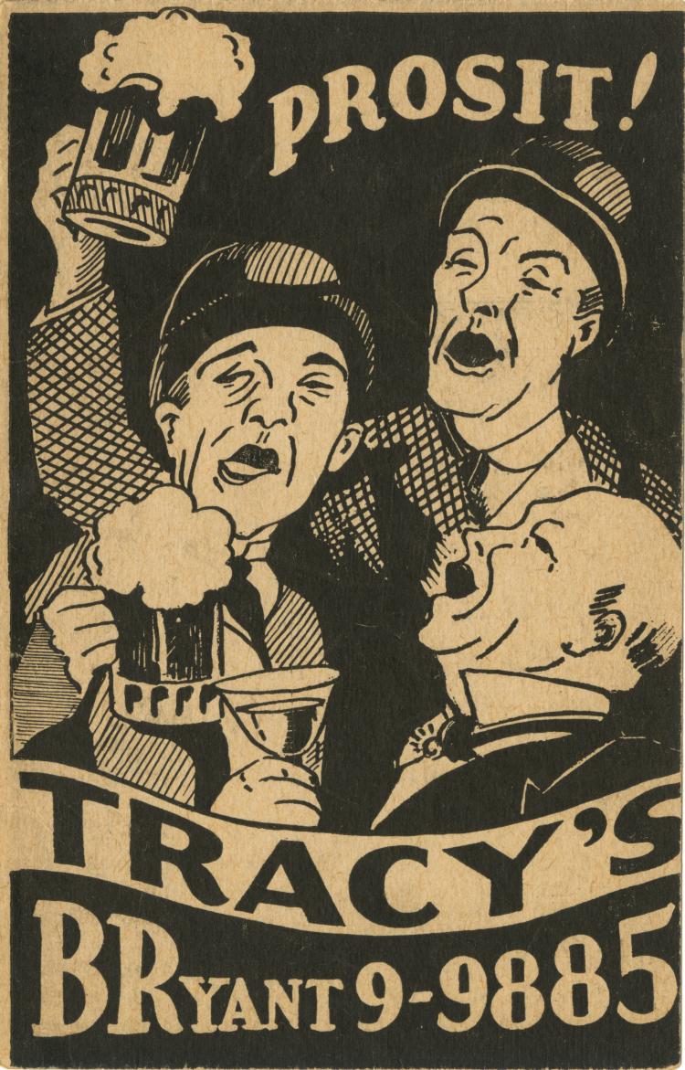
Image Text 3 Items [Tracy's bootleg liquor price list, between 1920 and 1933] One of a collection of twelve price lists for bootleg liquor and two business cards issued by liquor dealers who operated in New York City during Prohibition. The other price lists in this collection will be digitized in full at a future date. The 18th Amendment instituting national Prohibition went into effect Jan. 17, 1920, and was in force until it was repealed with the ratification of the 21st Amendment on Dec. 5, 1933. View Item
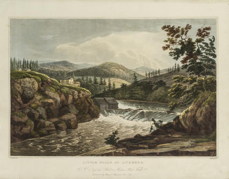
Image Still Image 20 Items The Hudson River port folio Plates from the Hudson River Portfolio, circa 1828. Title from cover. Engraved by John Hill and J.R. Smith from the watercolors of William G. Wall. View Item
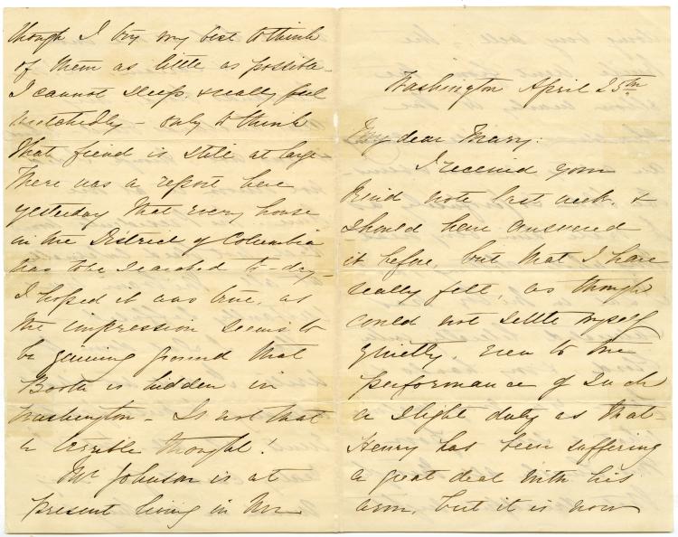
Image Text 4 Items Clara Harris letter to Mary, 1865 April 25 Autograph letter, signed, from Clara Harris, daughter of a U.S. Senator from New York, Ira Harris, and fiancée of Henry Reed Rathbone, to Mary, dated Washington, April 25th, 1865. Clara Harris, with Rathbone, accompanied Abraham and Mary Todd Lincoln to the theater on the night of April 14th, 1865, and was witness to the assassination of the President. The letter is a description of the events of that night, the grieving of the widowed First Lady, and the healing of Rathbone's stab wound. View Item
Text Total sales today 16,388,700. Good night. Oct. 29, 1929 Closing ticker tape from the New York Stock Exchange, October 29, 1929, the date of the Stock Market Crash that signaled the beginning of the Great Depression. View Item
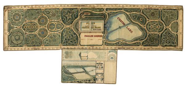
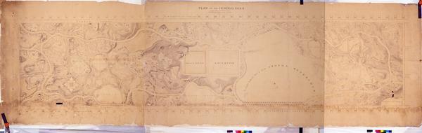
Still Image Plan of the Central Park, New York : entry no. 4 in the competition. March 20, 1858 The John Rink plan of Central Park. Number 4 of thirty-three submissions for the design competition for Central Park in Manhattan. It shows reservoirs, a parade ground, roads, plantings, and a monumental museum building (precursor of the Metropolitan Museum of Art) proposed for the south and east flanks of the Yorkville Reservoir. The plan is oriented with north to right of sheet. Ink and colored washes. References: Heckscher, M.H. Creating Central Park, p. 22. Rink was probably an engineer in the employ of the parks commissioners. View Item
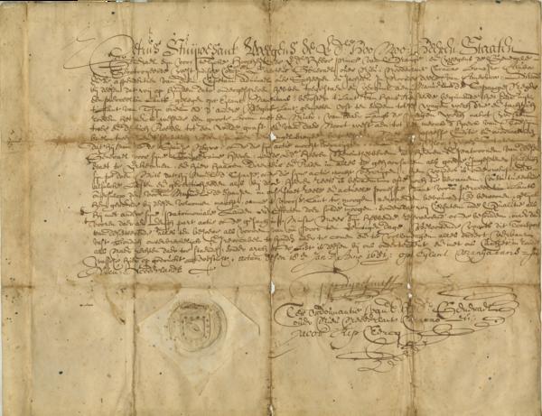
Text Peter Stuyvesant property deed to Manuel de Spangie, January 18, 1651 In 1649, Manuel de Spangie [or de Spanje], an enslaved man, purchased his freedom from his owner, Phillip Jansz Ringo, thus becoming one of the earliest free Blacks in New Amsterdam. Two years later, this property transaction would also make him one of Manhattan's earliest Black landowners. View Item
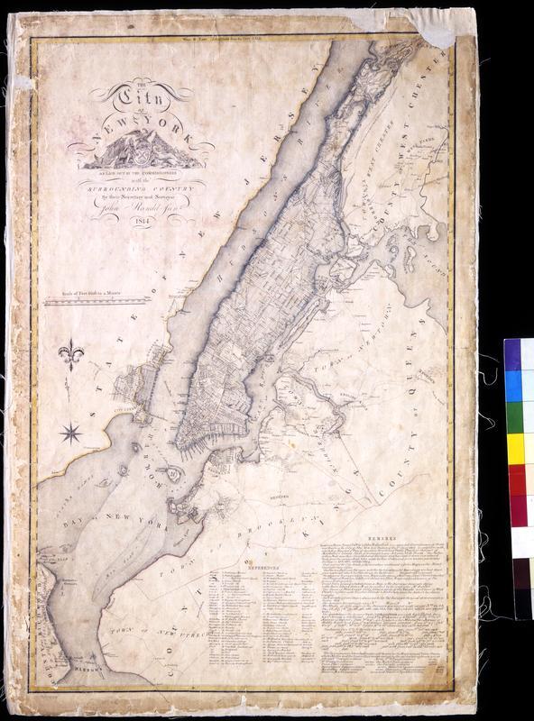
Still Image The City of New York as laid out by the Commissioners with the surrounding country / by their secretary and surveyor John Randel, Junr. Street planning map. Covers all of Manhattan Island (New York, N.Y.) and substantial parts of adjacent counties in New York and New Jersey. Shows existing and proposed streets; also buildings and other structures, streams and other wetlands, political boundaries. Includes extensive "REMARKS," also a key to New York City buildings. Pen-and-ink, watercolor on paper. Shows relief by hachures. Imperfect: lacking 4 x 9 and 2 x 5 cm. upper right corner, 2 x 2 cm. upper left side. References: Cohen, Paul E. and Robert T. Augustyn. Manhattan in Maps. NY: Rizzoli, 1997, p. 106ff; Stokes, I.N. Phelps. View Item
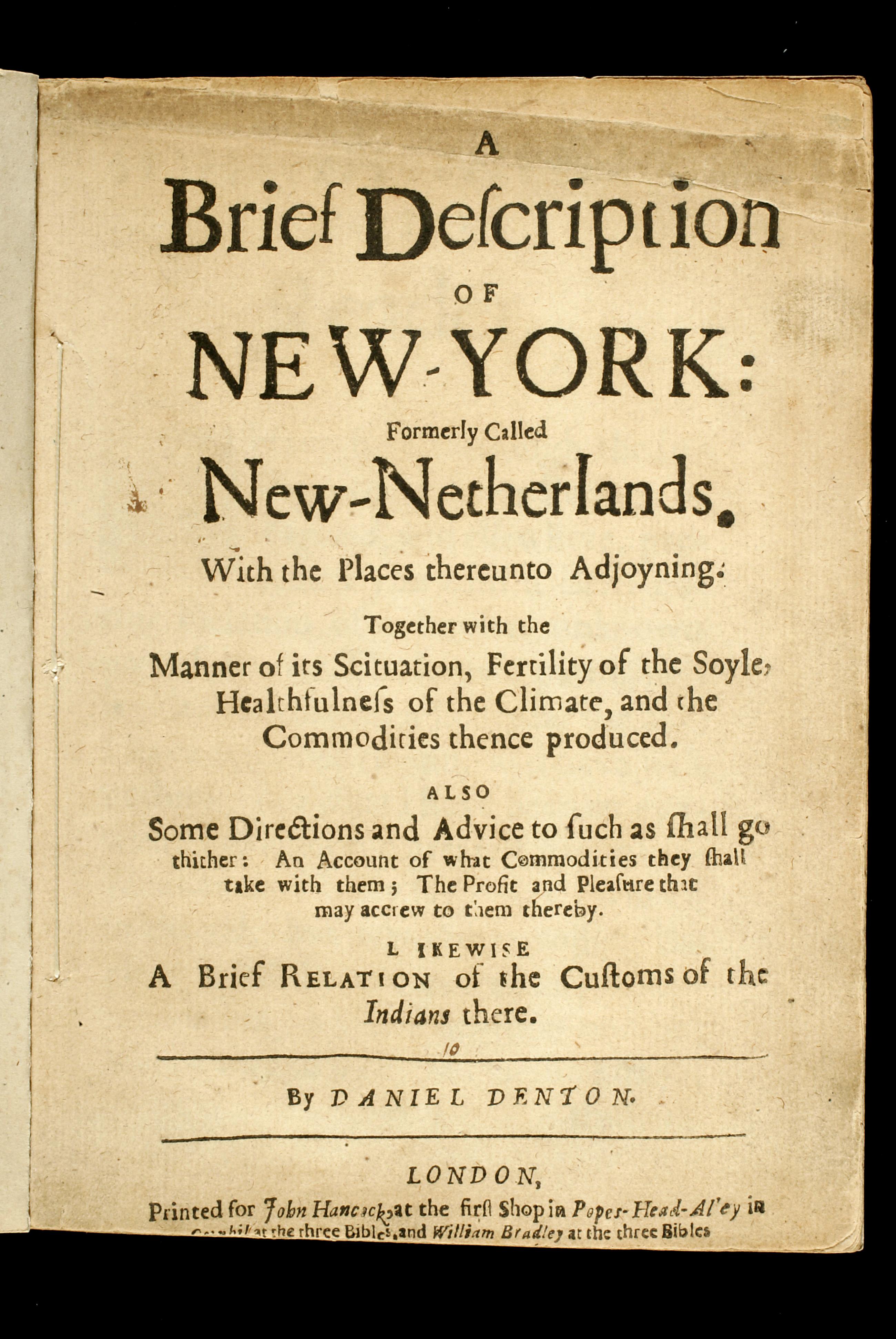
Text A brief description of New-York: formerly called New-Netherlands : with the places thereunto adjoyning : together with the manner of its scituation, fertility of the soyle, healthfulness of the climate, and the commodities thence produced : also some dire Title page of the first work promoting settlement of New York by the English after the capture of New Netherlands from the Dutch. The pamphlet has been digitized from microfilm by Columbia University and is available on the Internet Archive at https://archive.org/details/ldpd_6432836_000. New-York Historical's copy of the pamphlet will be digitized in full at a future date. Signatures: A-C⁴ D² (A1 a blank). References: Church, E. D. Discovery 608; Sabin 19611; Vail, R.W.G. Old frontier 157; Wing D-1062; ESTC R12462. Bookseller's advertisement on page 21. View Item
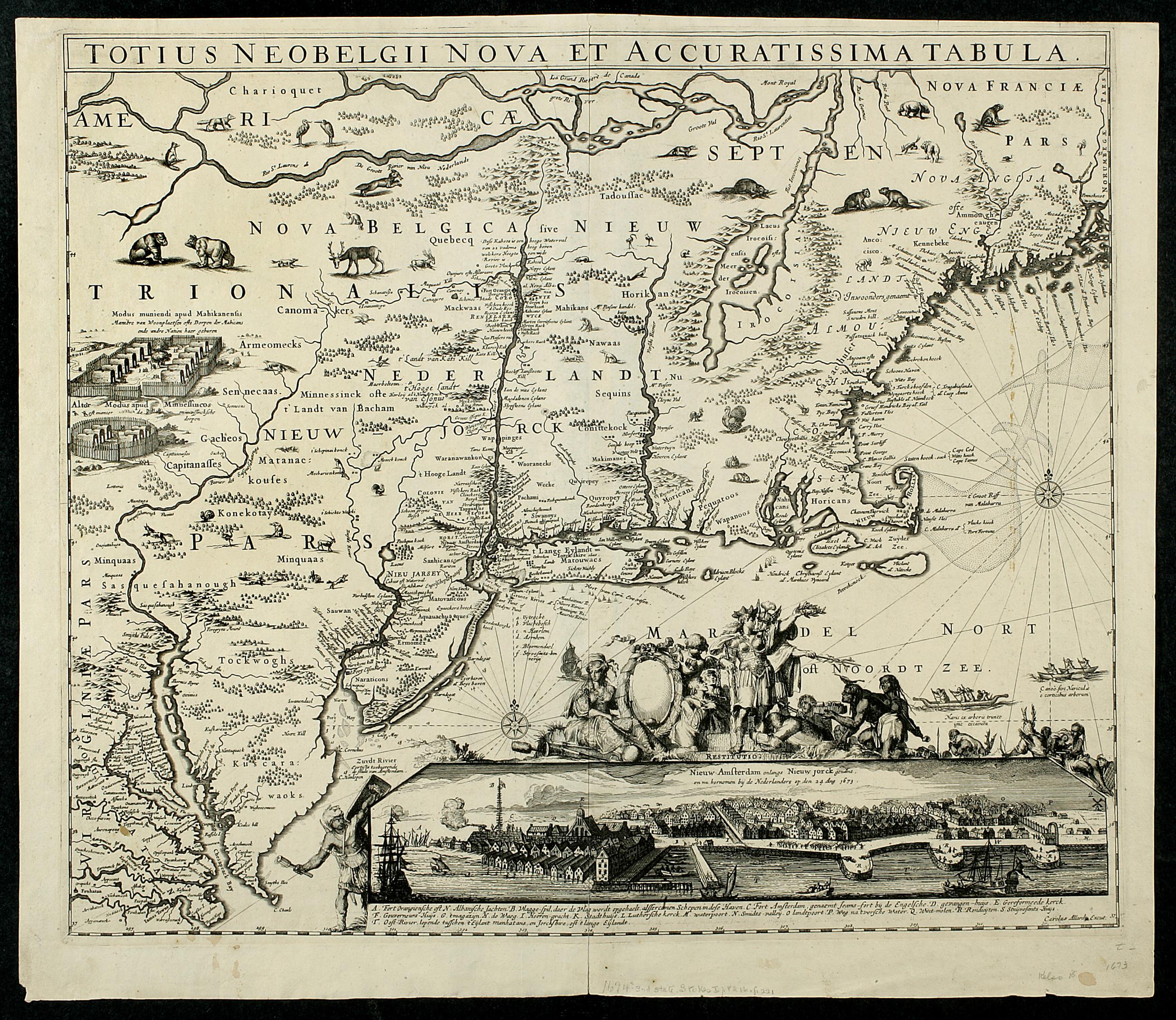
Still Image Totius Neobelgii nova et accuratissima tabula This map's image is a virtual duplicate of Joannes Jansson's "Belgii Novi Angliae," circa 1660, and some believe there was a common (Danckers) prototype. This map, of which only a few copies are known, is quite similar to the Visscher map with the most important difference being in the inset view of New York. The Allard view is a new engraving – the fifth in the sequence of engraved views of New York – made from a new drawing. When translated into English the caption identifies the view as "of New-Amsterdam lately called New York, and now retaken by the Netherlands on 14 Aug. View Item
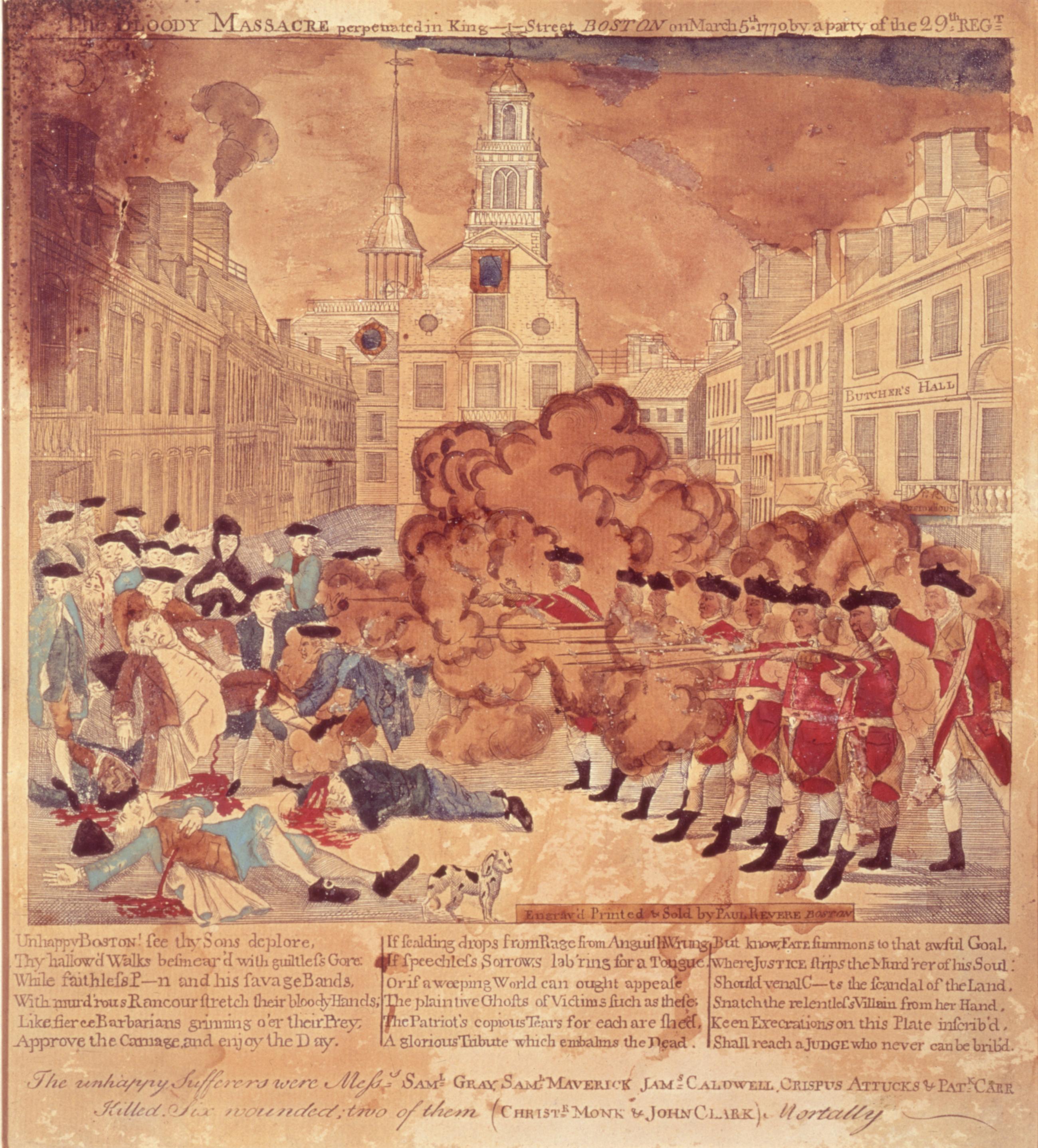
The bloody massacre perpetrated in King-Street, Boston on March 5th, 1770, by a party of the 29th Regt. : the unhappy sufferers were Mess.s Saml. Gray, Saml. Maverick, Jams. Caldwell, Crispus Attucks & Patk. Carr killed. Six wounded; two of them (Christe. The bloody massacre perpetrated in King-Street, Boston on March 5th, 1770, by a party of the 29th Regt. : the unhappy sufferers were Mess.s Saml. Gray, Saml. Maverick, Jams. Caldwell, Crispus Attucks & Patk. Carr killed. Six wounded; two of them (Christe. Hand-colored engraving. Paul Revere issued this famous print less than a month after the Boston Massacre, and it became an important piece of visual propaganda for colonial Americans. The New-York Historical Society's copy is one of the rare copies that show Crispus Attucks as a Black man. He was an American stevedore of African and Native American descent, widely regarded as the first person killed in the Boston Massacre and thus the first American killed in the American Revolution. View Item
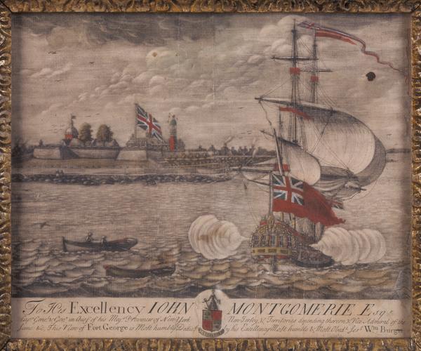
Still Image To His Excellency Iohn Montgomerie Esqr. Capn. Genel. & Govr. in Chief of His Maj's provinces of New-York, New-Jersey, & territories depending thereon, & Vice-Admiral of the same, &c., this view of Fort George is most humbly dedicd. by His Excellency's mo This unique copy of William Burgis's hand-colored mezzotint view of Fort George is the first known engraved view of New York City from the west and the first mezzotint view of the city. It emphasizes English control of Manhattan island with an oversized Union Jack, which is repeated on the warship in the harbor. View Item
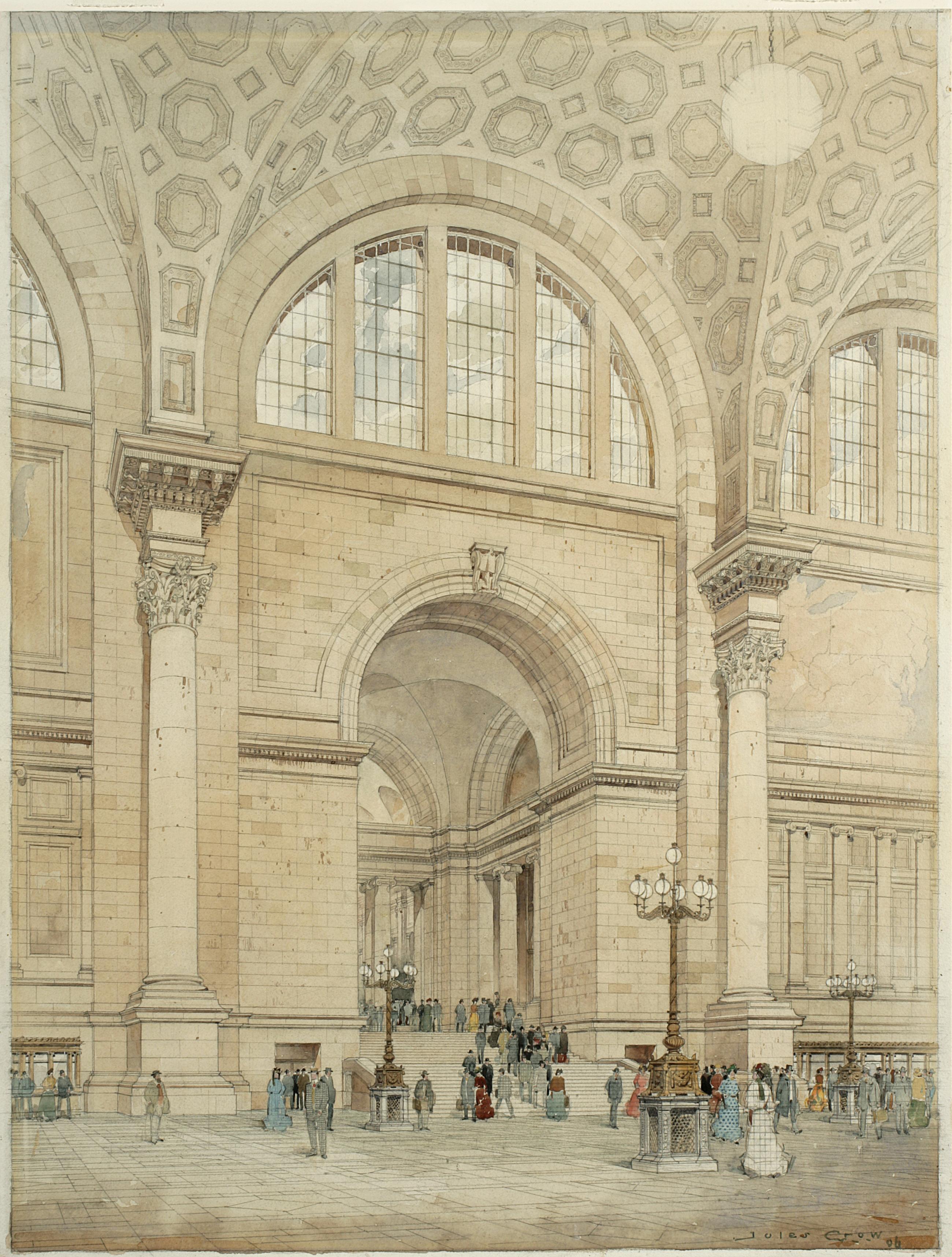
Still Image [Pennsylvania Station, New York, interior], Jules Crow, 1906 Presentation drawing of the interior of Pennsylvania Station, New York, from the McKim Mead & White architectural records held by the library at New-York Historical. Watercolor, ink and graphite on paper. View Item
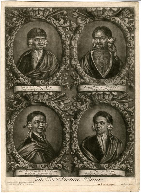
Still Image The four Indian kings, London, 1710 Mezzotint on paper engraved by Bernard Lens after sketches by Bernard Lens the Younger to commemorate the visit of four Native Americans to England in 1710. The four "kings", three Mohawk chiefs of the Iroquois Confederacy and one Mahican of the Algonquian peoples, are identified on the print as: Tee Yee Neen Ho Ga Row, Emperour of the Six Nations; Sa Ga Yean Qua Rah Tow, King of the Maquas; Oh Nee Yeath Tow No Riow, King of Ganajoh-Hore; and E Tow Oh Kaom, King of the River Nation. The print includes a manuscript note, "Sold by I. Clark, Grays Inn [London]". View Item
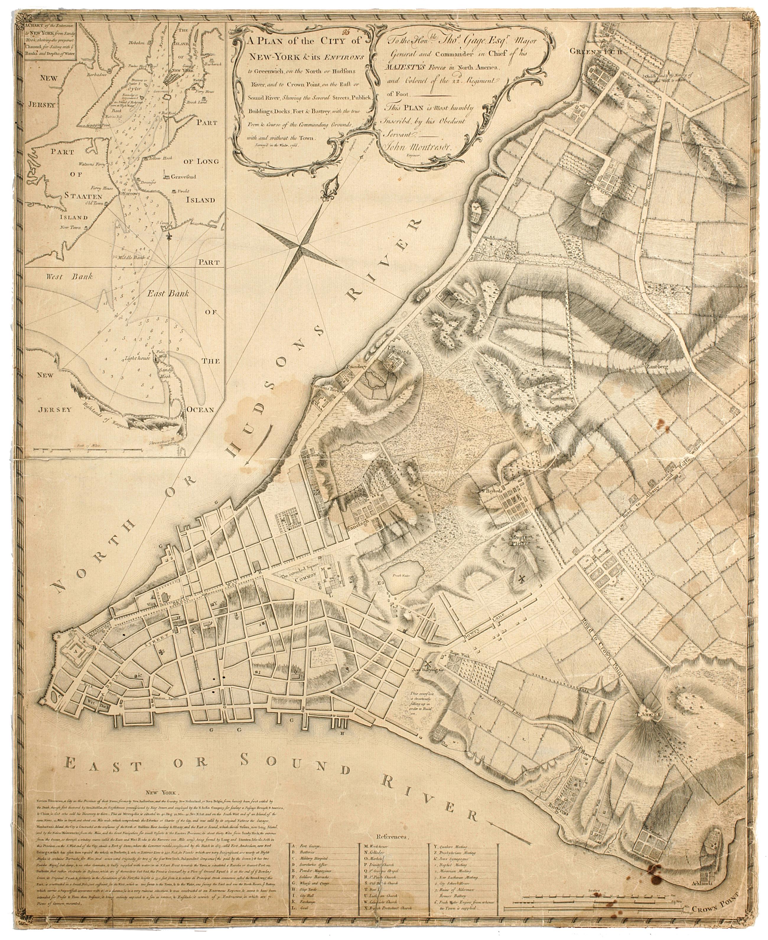
Still Image A plan of the city of New-York & its environs to Greenwich, : on the North or Hudsons River, and to Crown Point, on the East or Sound River, shewing the several streets, publick buildings, docks, fort & battery, with the true form & course of the commandi Cadastral map. Covers Manhattan, New York (N.Y.) south of the later Houston Street. Shows existing streets, some buildings, farms, docks, and names of property owners and natural landmarks. Relief shown by hachures. Black ink on paper backed with cloth. Includes text, index to points of interest, and inset "A chart of the entrance to New York from Sandy Hook, shewing the properest channel for sailing, with ye banks and depths of water," ca. 1:128,000. References: Stokes, Issac Newton Phelps. Iconography of Manhattan Island. View Item
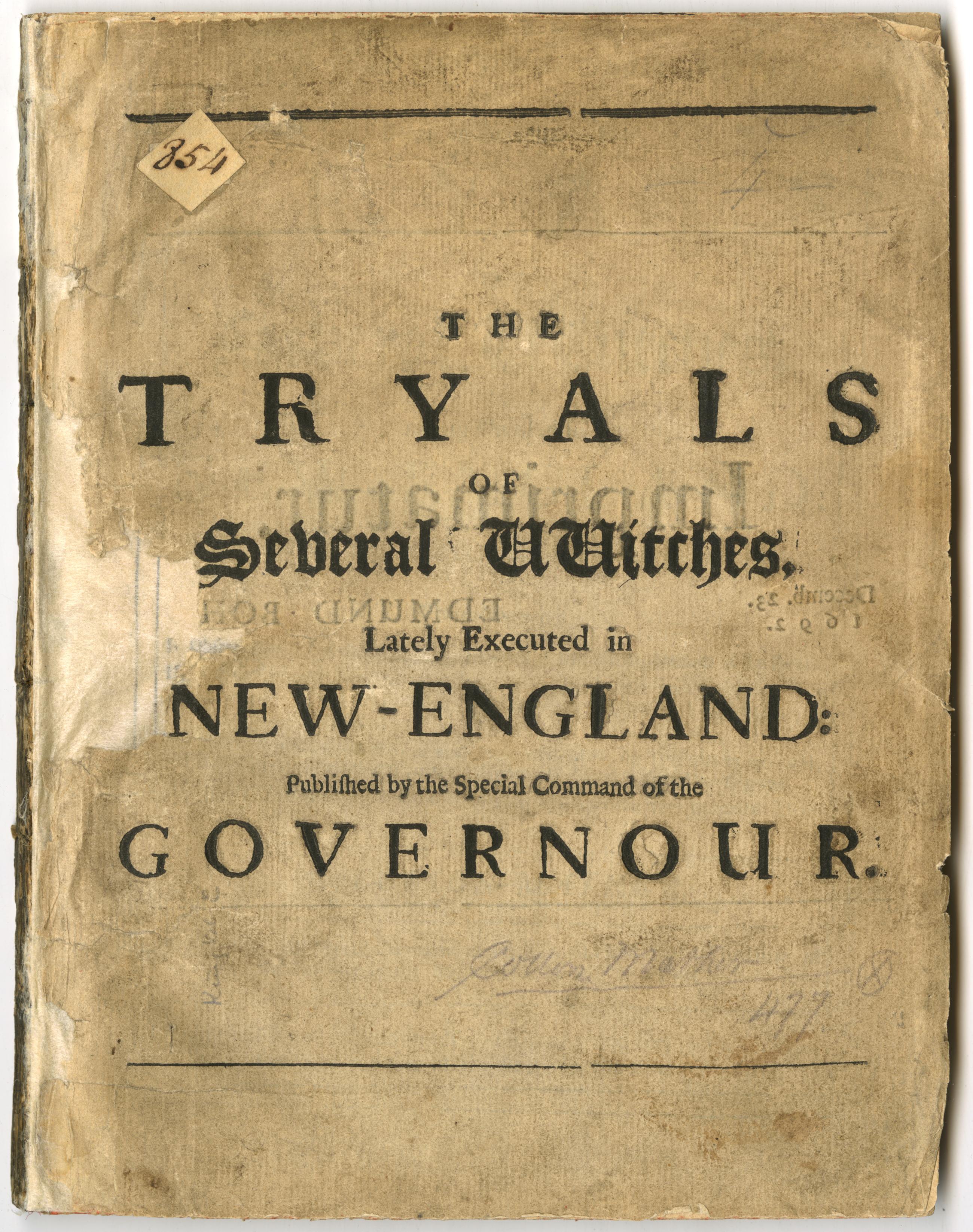
Text The wonders of the invisible world: : being an account of the tryals of several witches, lately excuted [sic] in New-England: and of several remarkable curiosities therein occurring. : Together with, I. Observations upon the nature, the number, and the op The half title of Cotton Mather's account of the Salem witch trials. The book will be digitized in full at a future date. Half title: The tryals of several vvitches, lately executed in New-England: Published by the special command of the Governour. "Imprimatur. Decem. 23. 1692. Edmund Bohun."--verso of half-title. Signatures: pi² A-K⁴ L-R². Text continuous despite pagination. References: ESTC R37620; Wing (CD-ROM, 1996) M1174; Holmes, T.J. C. Mather 454-B; JCB Lib. cat., 1675-1700 p. 271. "Advertisements. Books lately printed for John Dunton, at the Raven, in the Poultrey."--[2] p. at end. View Item
Still Image Plan of the Central Park : respectfully submitted to the Commissioners of the Park : March, 1858 : A.H.N. The George E. Waring, Jr. plan of Central Park. Number 29 of thirty-three submissions for the design competition for Central Park in Manhattan. It shows reservoirs, roads, plantings, a "Gymnasium and Drill Room" [arsenal], and a home for the Crystal Palace. Inscription on verso: "#29 of 33 plans submitted for competition, April 1858. Edw Selo Draughtsman, G.E. Waring author". The plan is oriented with north to right of sheet. Ink and colored washes. References: Heckscher, M.H. Creating Central Park, p. 23. View Item
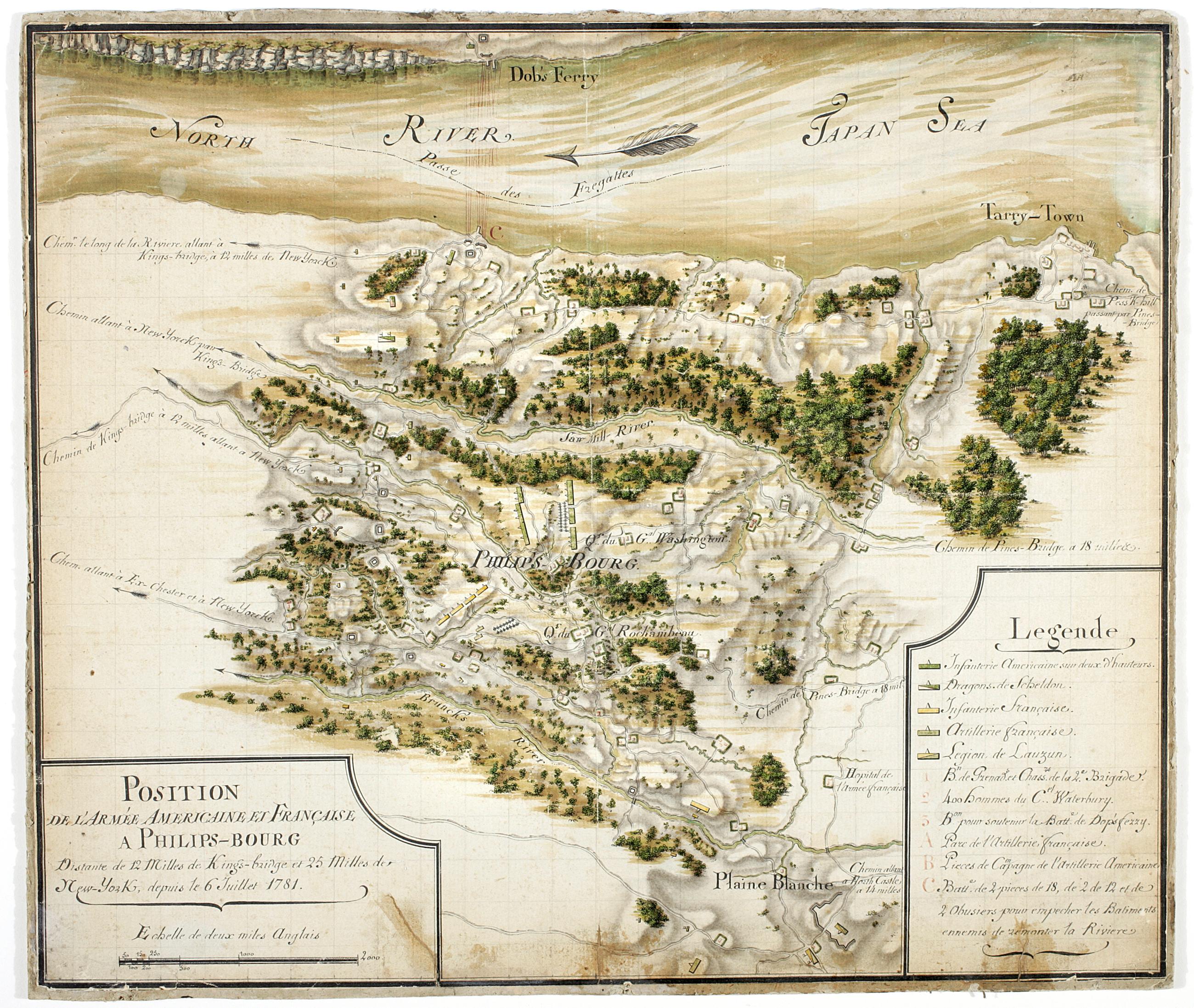
Still Image Position de 'larmee Américane et Française a Philips-bourg : distante de 12 milles de Kings-bridge et 25 milles de New-York, depuis le 6 Juillet 1781 Includes key. Military battlefield map. Covers the town of Greenburgh in Westchester County, New York: Shows disposition of troops, cavalry and artillery. Also shows roads running through Tarrytown, Dobbs Ferry and White Plains. Also shows buildings, landforms, streams and vegetative cover. On verso: "[?]aris Dessins topographiques" Pen-and-ink, watercolor on laid paper. Shows relief by shading. Stained, lightly soiled. Mounted on (probably contemporaneous) hardboard. View Item
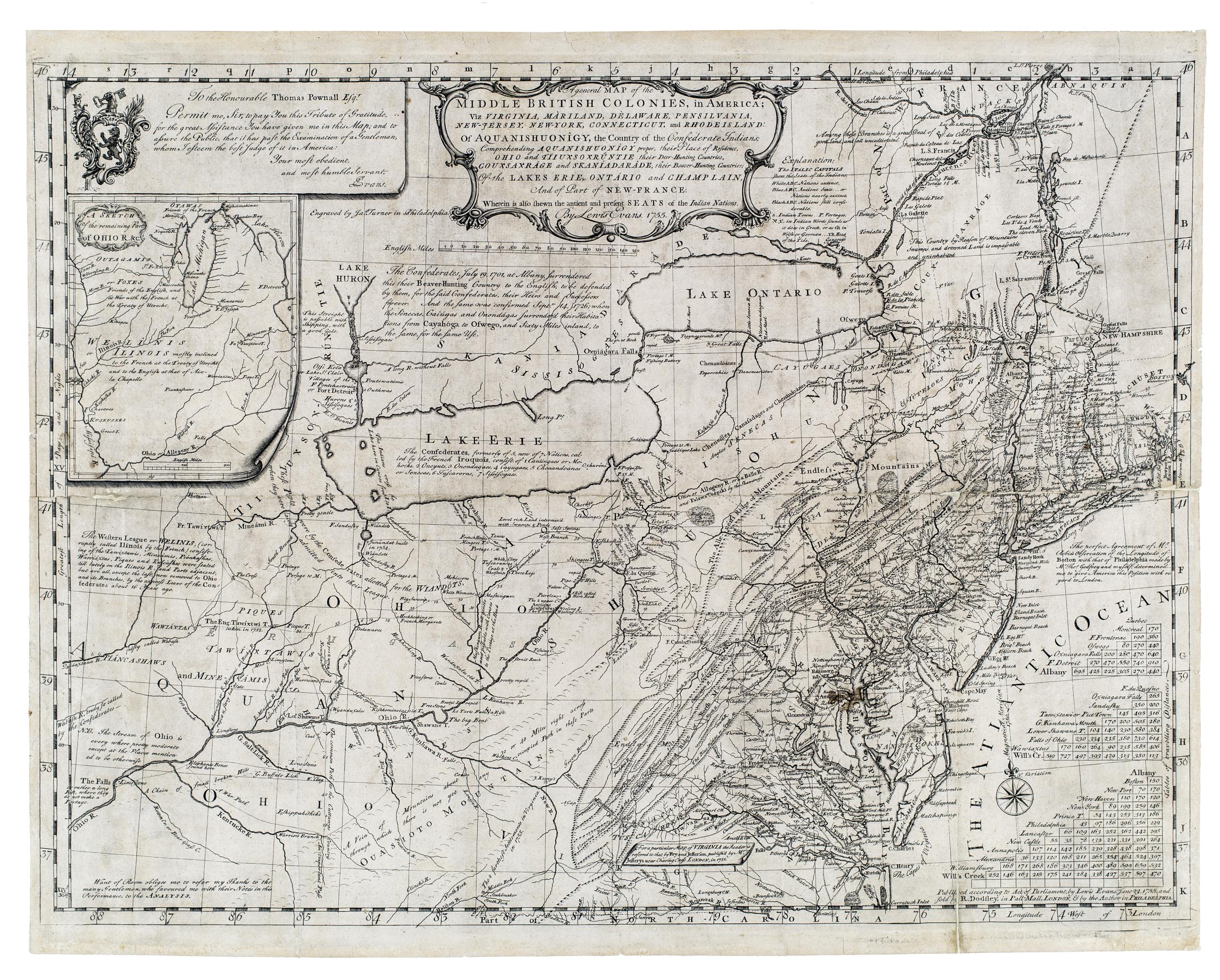
Still Image A general map of the middle British colonies, in America : viz Virginia, Màriland, Dèlaware, Pensilvania, New-Jersey, New-York, Connecticut, and Rhode Island : of Aquanishuonîgy, the country of the Confederate Indians ; comprehending Aquanishounigy proper Prime meridian: London and Philadelphia. Relief shown by hachures. From Evans, L. Geographical, historical, political, philosophical and mechanical essays, Philadelphia, 1755. Inset: A sketch of the remaining part of Ohio R. &c. "To the honourable Thomas Pownall Esqr. Permit me, Sir, to pay you this tribute of gratitude. for the great assistance you have given me in this map ... View Item
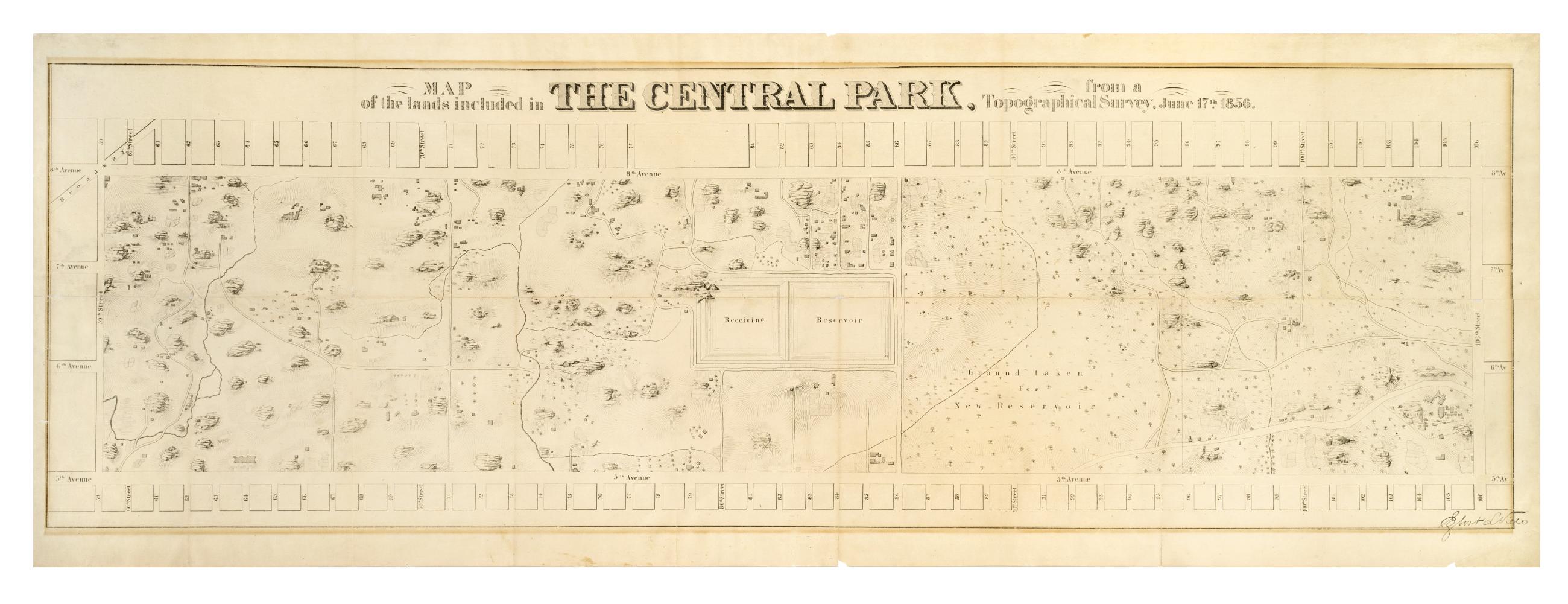
Still Image Map of the lands included in the Central Park, from a topographical survey, June 17th 1856 The Egbert L. Viele map of Central Park. Covers the area later bounded by 59th and 106th Streets, 5th Avenue and Central Park West, Manhattan, New York (N.Y.). Shows rock outcrops, buildings, reservoir, existing roads. Also shows landforms and streams. Shows relief by hachures. Oriented with north to right of sheet. "Engr. by Ferd. Mayer & Co." on companion map. From First Annual Report of the Board of Commissioners of the Central Park, January 1857. View Item
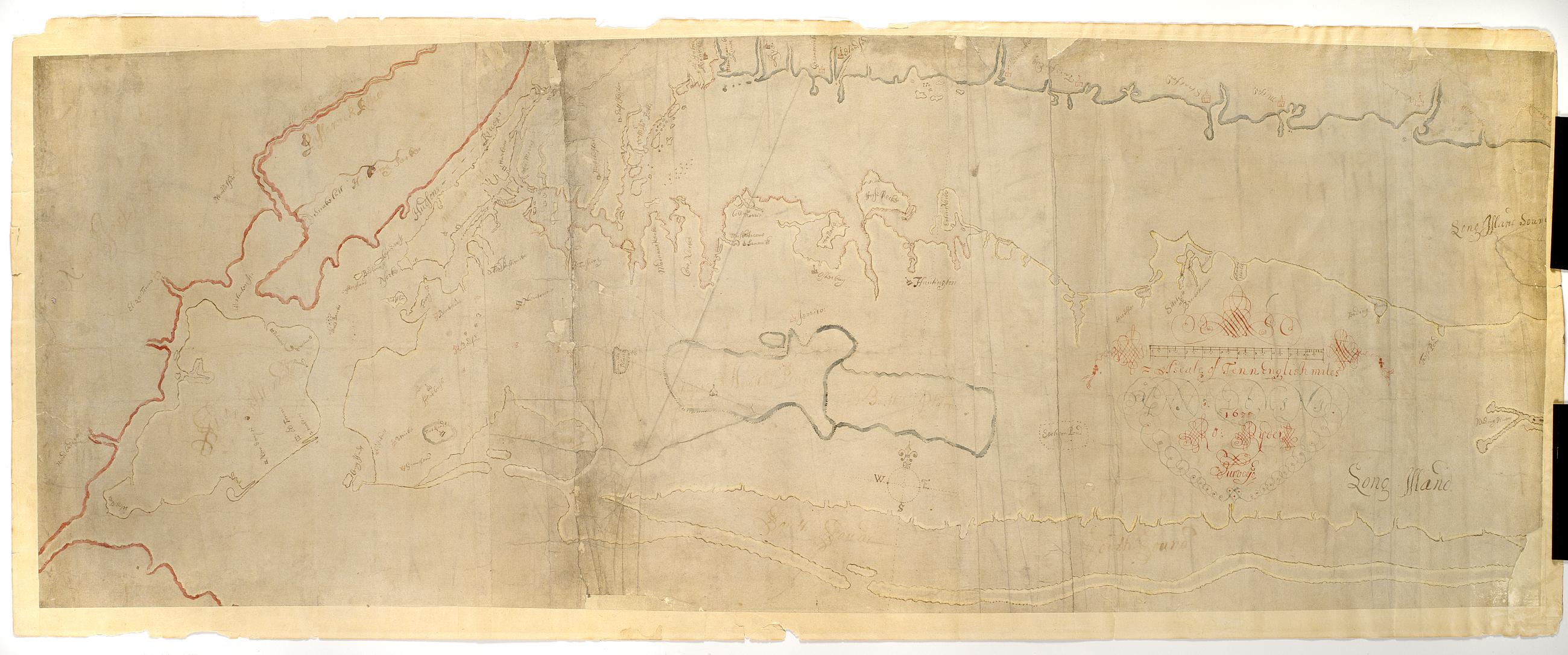
Still Image [Map of Long Island and adjacent areas of Connecticut, New York and New Jersey] / Ro. Ryder surveyed Pen-and-ink (black and color), color wash on laid paper. This is the manuscript of the earliest survey known of Long Island as far east as Riverhead. "ANNO DOMINI 1670" embedded in cartouche decoration. A shoreline map, it shows most of Long Island, all of modern New York City and the shorelines of Connecticut and New Jersey, marks the rocky coast in red, gives placenames, and outlines the various colonies in different colors. View Item
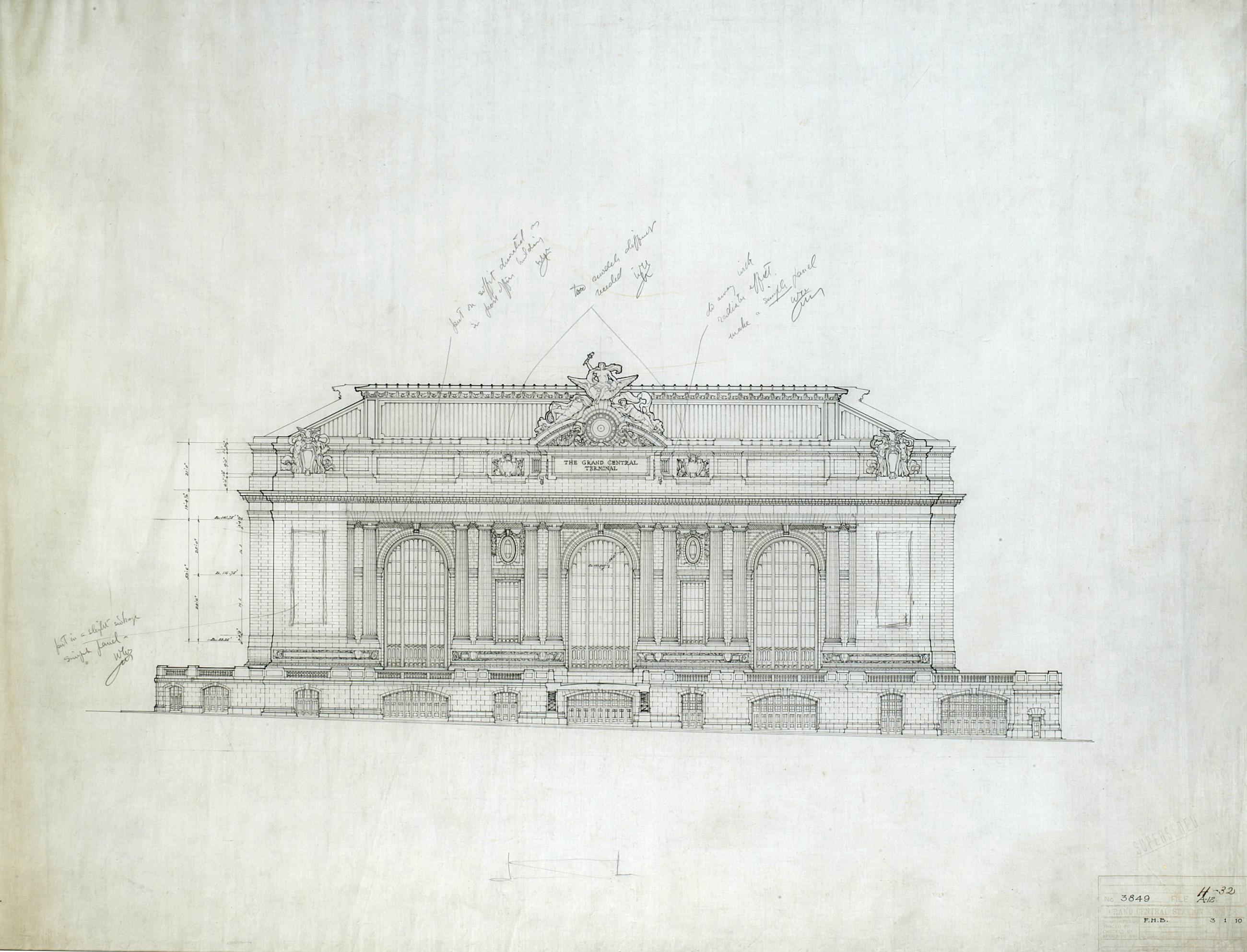
Still Image [Grand Central Terminal, elevation on 42nd Street, Warren & Wetmore, circa 1904] Ink on linen with pencil revisions and annotations. View Item
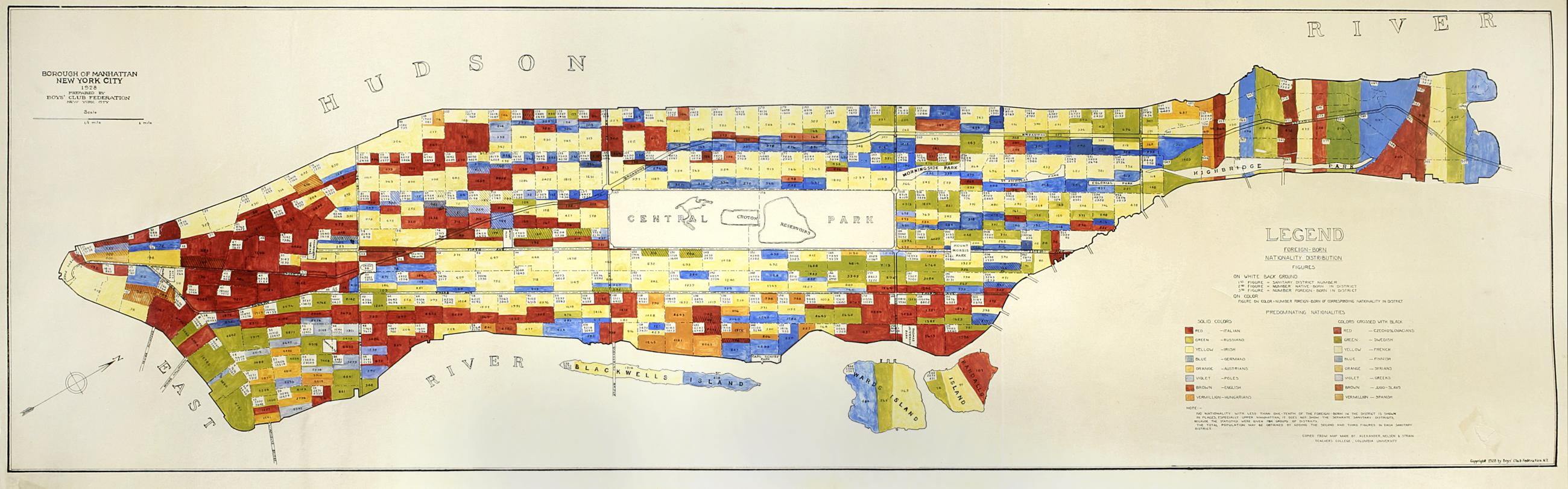
Still Image Borough of Manhattan, New York City, 1928 : Foreign-born nationality distribution figures / prepared by Boys' Club Federation, New York City Subtitle from legend: Foreign-born nationality distribution figures. Map and legend are hand colored, some areas are hand numbered. "Copied from map made by Alexander, Nelsen and Strain, Teachers College, Columbia University." View Item
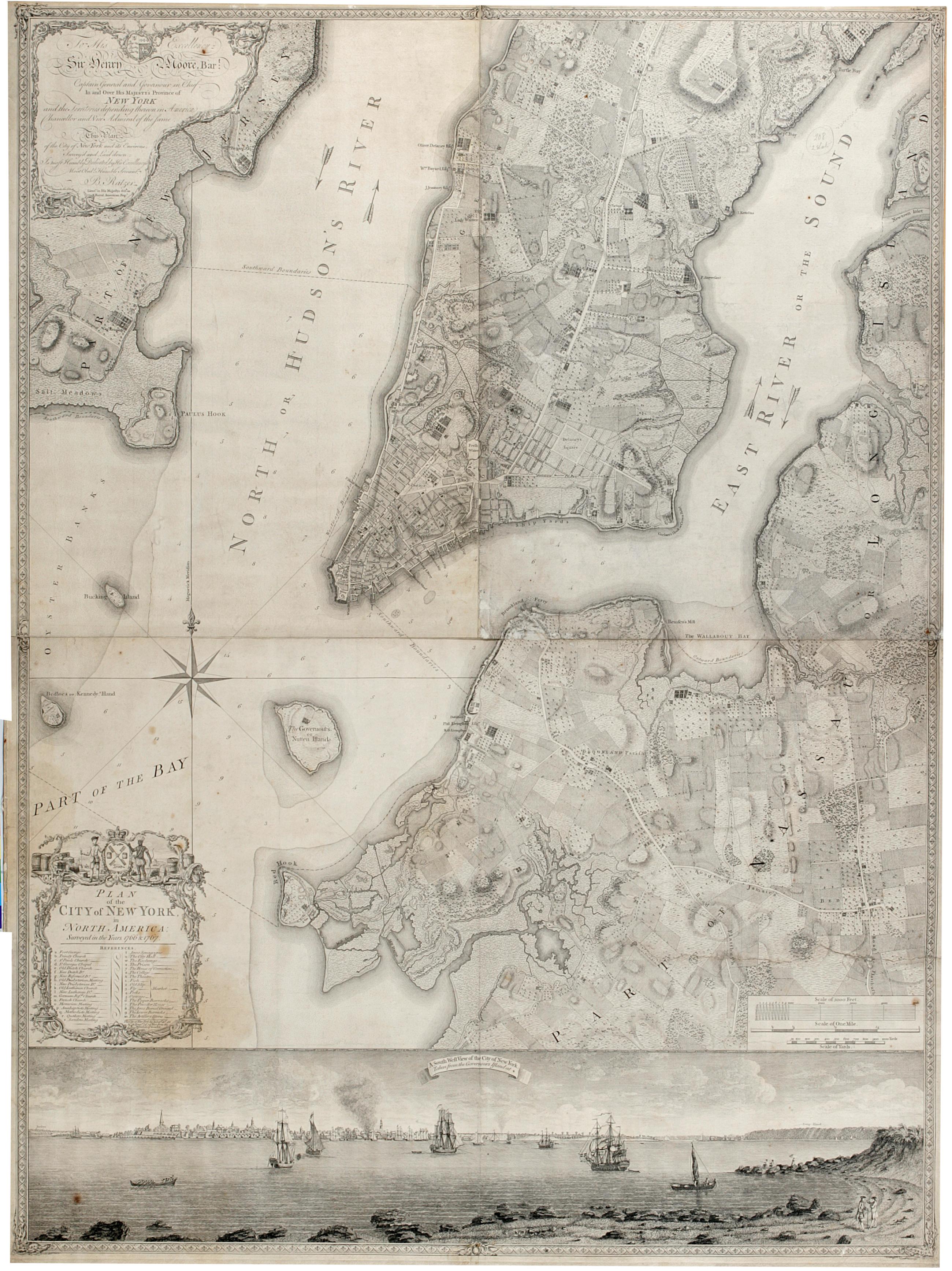
Still Image Plan of the city of New York in North America : surveyed in the years 1766 & 1767. The Ratzer map of New York City. First state, 1770. Covers part of modern New York City: Manhattan below the later 60th Street and Brooklyn north of the later 30th Street and west of the later Union Avenue; also a small part of modern Queens and of Jersey City, New Jersey. Shows built up and cultivated areas, streets and rural roads, some buildings, piers. Also shows streams, ponds and wetlands. Shows relief by hachures. Shows depths by soundings. Dedication at upper left: "To His Excellency Sir Henry Moore, Bart. View Item
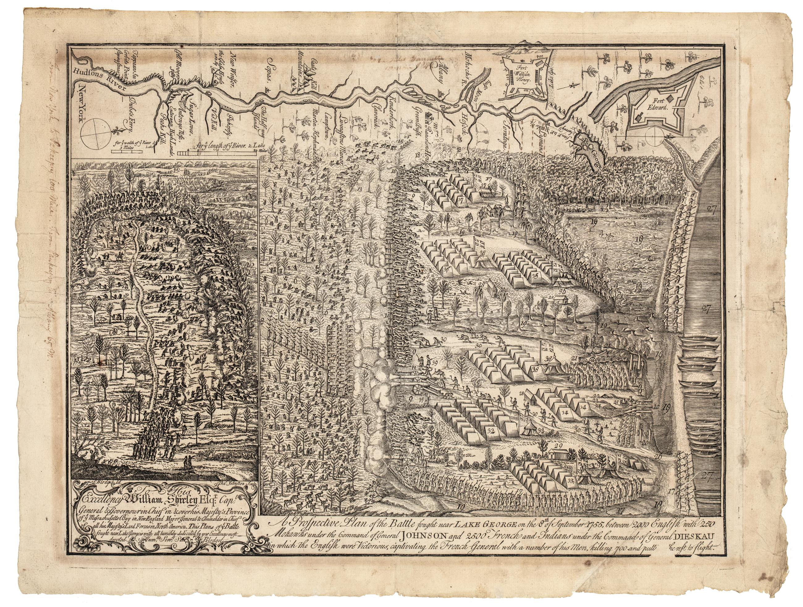
Still Image A prospective plan of the battle fought near Lake George on the 8th of September, 1755 : between 2000 English with 250 Mohawks under the command of general Johnson and 2500 French and Indians under the command of general Dieskau in which the English were This is the first historical print engraved in America. Blodget witnessed the battle and immediately afterwards drew the original plan from which Thomas Johnston made the line engraving. Relief shown pictorally. New-York Historical's copy: Handwritten note on side of map, "From New York to Pakeepsy 100 Miles. From Paukeepsy to Albany 65 m." View Item
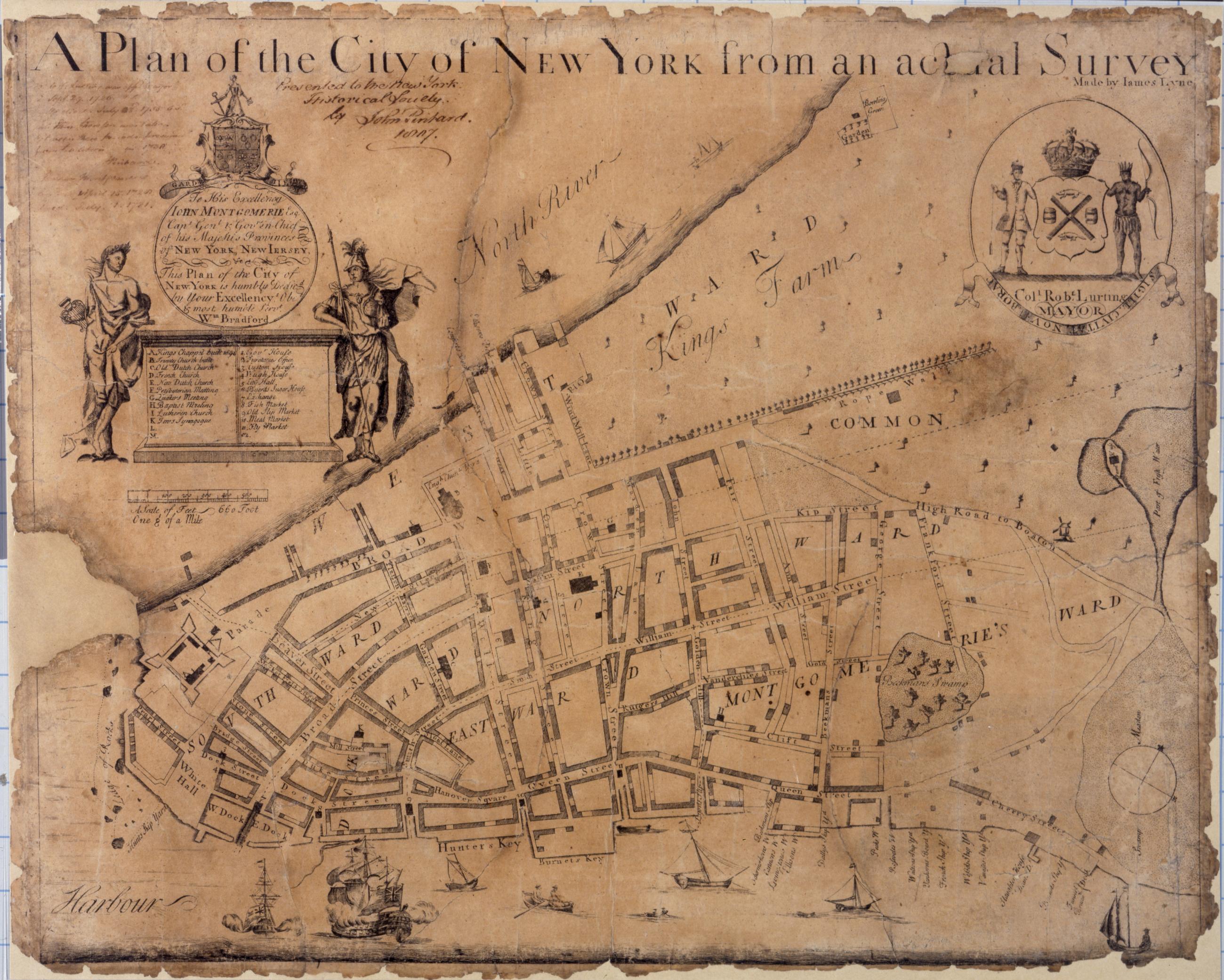
Still Image A plan of the city of New York from an actual survey, made by James Lyne Known as the Bradford map, this is the first map of New York printed in the city itself. It is dated to 1731 on the basis of an advertisement in the New York Gazette, August 30-September 6, 1731. Covers lower Manhattan. Shows wards, streets, and public buildings. Oriented with north toward the upper right. Includes index to points of interest. In cartouche at upper left: "To his excellency John Montgomerie, Esq. Capt. Genl. & Gov. View Item
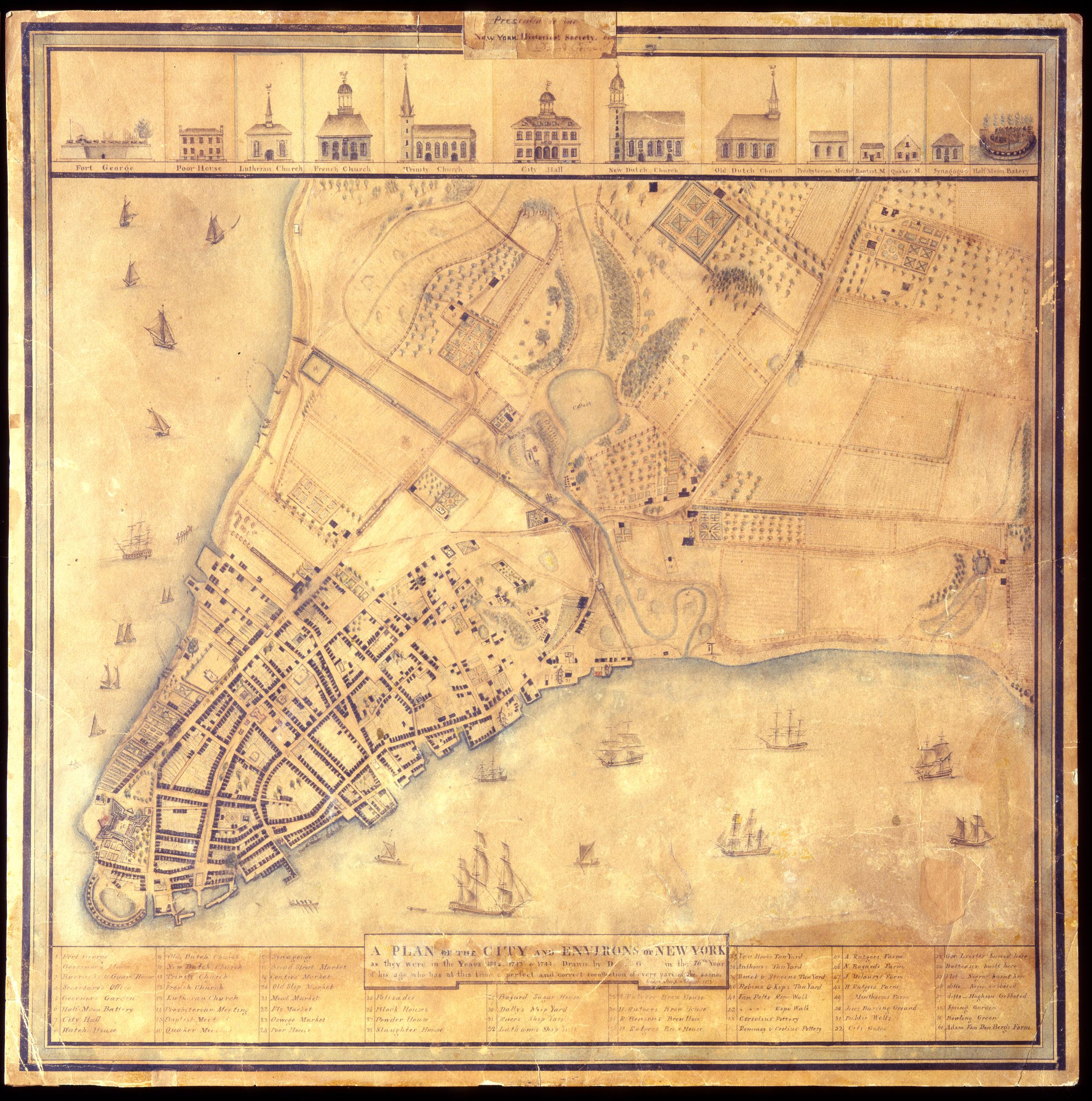
Still Image A Plan of the city and environs of New York as they were in the years 1742. 1743. & 1744. / drawn by D--- G--- in the 76th year of his age, who has at this time a perfect and correct recollection of every part of the same. Cedar Street. August 1813. David Grim's map of prerevolutionary Manhattan. Historical map. Covers Manhattan Island south of modern 14th Street, New York (N.Y.). Shows buildings and many other urban features; also shows natural and agricultural features. Date of ms. 1813 Aug. Date of situation between 1742 and 1744. On label pasted at top center: "Presented to the New York Historical Society by David Grim". Pen-and-ink (black and color), watercolor, pencil on paper. Selected material shown pictorially. Includes index. References: Cohen, Paul E. and Robert T. Augustyn. Manhattan in Maps, p. 62-63; Stokes, I.N. Phelps. View Item
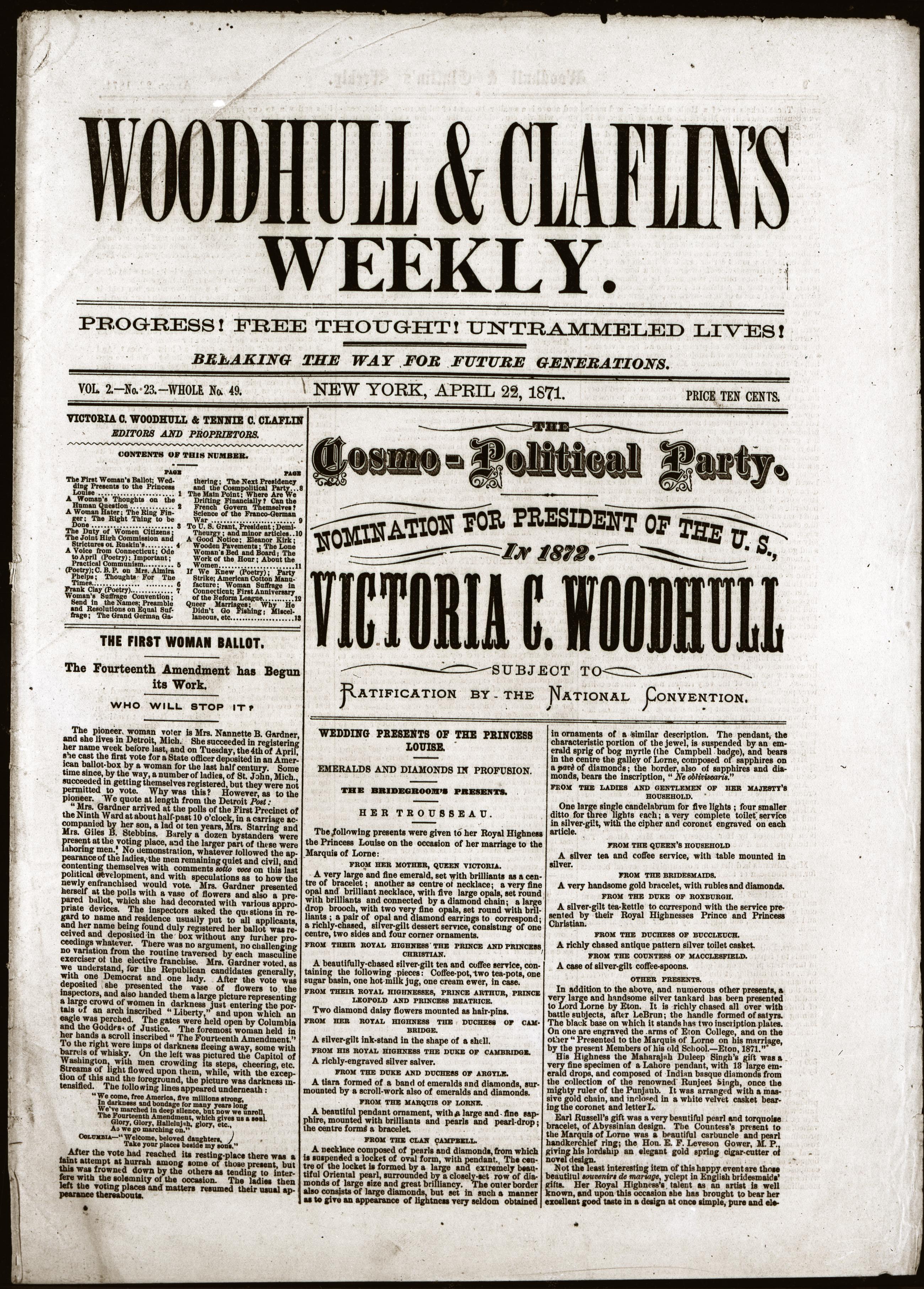
Woodhull & Claflin's weekly : Progress! Free thought! Untrammeled lives! Breaking the way for future generations, Vol. 2, No. 23, whole No. 49, New York, April 22, 1871, page [1] Woodhull & Claflin's weekly : Progress! Free thought! Untrammeled lives! Breaking the way for future generations, Vol. 2, No. 23, whole No. 49, New York, April 22, 1871, page [1] View Item
Text Total sales today 16,388,700. Good night. Oct. 29, 1929 Closing ticker tape from the New York Stock Exchange, October 29, 1929, the date of the Stock Market Crash that signaled the beginning of the Great Depression. View Item
Still Image Plan of the Central Park, New York : entry no. 4 in the competition. March 20, 1858 The John Rink plan of Central Park. Number 4 of thirty-three submissions for the design competition for Central Park in Manhattan. It shows reservoirs, a parade ground, roads, plantings, and a monumental museum building (precursor of the Metropolitan Museum of Art) proposed for the south and east flanks of the Yorkville Reservoir. The plan is oriented with north to right of sheet. Ink and colored washes. References: Heckscher, M.H. Creating Central Park, p. 22. Rink was probably an engineer in the employ of the parks commissioners. View Item
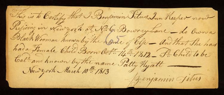
Text Peter Stuyvesant property deed to Manuel de Spangie, January 18, 1651 In 1649, Manuel de Spangie [or de Spanje], an enslaved man, purchased his freedom from his owner, Phillip Jansz Ringo, thus becoming one of the earliest free Blacks in New Amsterdam. Two years later, this property transaction would also make him one of Manhattan's earliest Black landowners. View Item
Still Image The City of New York as laid out by the Commissioners with the surrounding country / by their secretary and surveyor John Randel, Junr. Street planning map. Covers all of Manhattan Island (New York, N.Y.) and substantial parts of adjacent counties in New York and New Jersey. Shows existing and proposed streets; also buildings and other structures, streams and other wetlands, political boundaries. Includes extensive "REMARKS," also a key to New York City buildings. Pen-and-ink, watercolor on paper. Shows relief by hachures. Imperfect: lacking 4 x 9 and 2 x 5 cm. upper right corner, 2 x 2 cm. upper left side. References: Cohen, Paul E. and Robert T. Augustyn. Manhattan in Maps. NY: Rizzoli, 1997, p. 106ff; Stokes, I.N. Phelps. View Item
Text A brief description of New-York: formerly called New-Netherlands : with the places thereunto adjoyning : together with the manner of its scituation, fertility of the soyle, healthfulness of the climate, and the commodities thence produced : also some dire Title page of the first work promoting settlement of New York by the English after the capture of New Netherlands from the Dutch. The pamphlet has been digitized from microfilm by Columbia University and is available on the Internet Archive at https://archive.org/details/ldpd_6432836_000. New-York Historical's copy of the pamphlet will be digitized in full at a future date. Signatures: A-C⁴ D² (A1 a blank). References: Church, E. D. Discovery 608; Sabin 19611; Vail, R.W.G. Old frontier 157; Wing D-1062; ESTC R12462. Bookseller's advertisement on page 21. View Item
Still Image Totius Neobelgii nova et accuratissima tabula This map's image is a virtual duplicate of Joannes Jansson's "Belgii Novi Angliae," circa 1660, and some believe there was a common (Danckers) prototype. This map, of which only a few copies are known, is quite similar to the Visscher map with the most important difference being in the inset view of New York. The Allard view is a new engraving – the fifth in the sequence of engraved views of New York – made from a new drawing. When translated into English the caption identifies the view as "of New-Amsterdam lately called New York, and now retaken by the Netherlands on 14 Aug. View Item
The bloody massacre perpetrated in King-Street, Boston on March 5th, 1770, by a party of the 29th Regt. : the unhappy sufferers were Mess.s Saml. Gray, Saml. Maverick, Jams. Caldwell, Crispus Attucks & Patk. Carr killed. Six wounded; two of them (Christe. The bloody massacre perpetrated in King-Street, Boston on March 5th, 1770, by a party of the 29th Regt. : the unhappy sufferers were Mess.s Saml. Gray, Saml. Maverick, Jams. Caldwell, Crispus Attucks & Patk. Carr killed. Six wounded; two of them (Christe. Hand-colored engraving. Paul Revere issued this famous print less than a month after the Boston Massacre, and it became an important piece of visual propaganda for colonial Americans. The New-York Historical Society's copy is one of the rare copies that show Crispus Attucks as a Black man. He was an American stevedore of African and Native American descent, widely regarded as the first person killed in the Boston Massacre and thus the first American killed in the American Revolution. View Item
Still Image To His Excellency Iohn Montgomerie Esqr. Capn. Genel. & Govr. in Chief of His Maj's provinces of New-York, New-Jersey, & territories depending thereon, & Vice-Admiral of the same, &c., this view of Fort George is most humbly dedicd. by His Excellency's mo This unique copy of William Burgis's hand-colored mezzotint view of Fort George is the first known engraved view of New York City from the west and the first mezzotint view of the city. It emphasizes English control of Manhattan island with an oversized Union Jack, which is repeated on the warship in the harbor. View Item
Still Image [Pennsylvania Station, New York, interior], Jules Crow, 1906 Presentation drawing of the interior of Pennsylvania Station, New York, from the McKim Mead & White architectural records held by the library at New-York Historical. Watercolor, ink and graphite on paper. View Item
Still Image The four Indian kings, London, 1710 Mezzotint on paper engraved by Bernard Lens after sketches by Bernard Lens the Younger to commemorate the visit of four Native Americans to England in 1710. The four "kings", three Mohawk chiefs of the Iroquois Confederacy and one Mahican of the Algonquian peoples, are identified on the print as: Tee Yee Neen Ho Ga Row, Emperour of the Six Nations; Sa Ga Yean Qua Rah Tow, King of the Maquas; Oh Nee Yeath Tow No Riow, King of Ganajoh-Hore; and E Tow Oh Kaom, King of the River Nation. The print includes a manuscript note, "Sold by I. Clark, Grays Inn [London]". View Item
Still Image A plan of the city of New-York & its environs to Greenwich, : on the North or Hudsons River, and to Crown Point, on the East or Sound River, shewing the several streets, publick buildings, docks, fort & battery, with the true form & course of the commandi Cadastral map. Covers Manhattan, New York (N.Y.) south of the later Houston Street. Shows existing streets, some buildings, farms, docks, and names of property owners and natural landmarks. Relief shown by hachures. Black ink on paper backed with cloth. Includes text, index to points of interest, and inset "A chart of the entrance to New York from Sandy Hook, shewing the properest channel for sailing, with ye banks and depths of water," ca. 1:128,000. References: Stokes, Issac Newton Phelps. Iconography of Manhattan Island. View Item
Text The wonders of the invisible world: : being an account of the tryals of several witches, lately excuted [sic] in New-England: and of several remarkable curiosities therein occurring. : Together with, I. Observations upon the nature, the number, and the op The half title of Cotton Mather's account of the Salem witch trials. The book will be digitized in full at a future date. Half title: The tryals of several vvitches, lately executed in New-England: Published by the special command of the Governour. "Imprimatur. Decem. 23. 1692. Edmund Bohun."--verso of half-title. Signatures: pi² A-K⁴ L-R². Text continuous despite pagination. References: ESTC R37620; Wing (CD-ROM, 1996) M1174; Holmes, T.J. C. Mather 454-B; JCB Lib. cat., 1675-1700 p. 271. "Advertisements. Books lately printed for John Dunton, at the Raven, in the Poultrey."--[2] p. at end. View Item
Still Image Plan of the Central Park : respectfully submitted to the Commissioners of the Park : March, 1858 : A.H.N. The George E. Waring, Jr. plan of Central Park. Number 29 of thirty-three submissions for the design competition for Central Park in Manhattan. It shows reservoirs, roads, plantings, a "Gymnasium and Drill Room" [arsenal], and a home for the Crystal Palace. Inscription on verso: "#29 of 33 plans submitted for competition, April 1858. Edw Selo Draughtsman, G.E. Waring author". The plan is oriented with north to right of sheet. Ink and colored washes. References: Heckscher, M.H. Creating Central Park, p. 23. View Item
Still Image Position de 'larmee Américane et Française a Philips-bourg : distante de 12 milles de Kings-bridge et 25 milles de New-York, depuis le 6 Juillet 1781 Includes key. Military battlefield map. Covers the town of Greenburgh in Westchester County, New York: Shows disposition of troops, cavalry and artillery. Also shows roads running through Tarrytown, Dobbs Ferry and White Plains. Also shows buildings, landforms, streams and vegetative cover. On verso: "[?]aris Dessins topographiques" Pen-and-ink, watercolor on laid paper. Shows relief by shading. Stained, lightly soiled. Mounted on (probably contemporaneous) hardboard. View Item
Still Image A general map of the middle British colonies, in America : viz Virginia, Màriland, Dèlaware, Pensilvania, New-Jersey, New-York, Connecticut, and Rhode Island : of Aquanishuonîgy, the country of the Confederate Indians ; comprehending Aquanishounigy proper Prime meridian: London and Philadelphia. Relief shown by hachures. From Evans, L. Geographical, historical, political, philosophical and mechanical essays, Philadelphia, 1755. Inset: A sketch of the remaining part of Ohio R. &c. "To the honourable Thomas Pownall Esqr. Permit me, Sir, to pay you this tribute of gratitude. for the great assistance you have given me in this map ... View Item
Still Image Map of the lands included in the Central Park, from a topographical survey, June 17th 1856 The Egbert L. Viele map of Central Park. Covers the area later bounded by 59th and 106th Streets, 5th Avenue and Central Park West, Manhattan, New York (N.Y.). Shows rock outcrops, buildings, reservoir, existing roads. Also shows landforms and streams. Shows relief by hachures. Oriented with north to right of sheet. "Engr. by Ferd. Mayer & Co." on companion map. From First Annual Report of the Board of Commissioners of the Central Park, January 1857. View Item
Still Image [Map of Long Island and adjacent areas of Connecticut, New York and New Jersey] / Ro. Ryder surveyed Pen-and-ink (black and color), color wash on laid paper. This is the manuscript of the earliest survey known of Long Island as far east as Riverhead. "ANNO DOMINI 1670" embedded in cartouche decoration. A shoreline map, it shows most of Long Island, all of modern New York City and the shorelines of Connecticut and New Jersey, marks the rocky coast in red, gives placenames, and outlines the various colonies in different colors. View Item
Still Image [Grand Central Terminal, elevation on 42nd Street, Warren & Wetmore, circa 1904] Ink on linen with pencil revisions and annotations. View Item
Still Image Borough of Manhattan, New York City, 1928 : Foreign-born nationality distribution figures / prepared by Boys' Club Federation, New York City Subtitle from legend: Foreign-born nationality distribution figures. Map and legend are hand colored, some areas are hand numbered. "Copied from map made by Alexander, Nelsen and Strain, Teachers College, Columbia University." View Item
Still Image Plan of the city of New York in North America : surveyed in the years 1766 & 1767. The Ratzer map of New York City. First state, 1770. Covers part of modern New York City: Manhattan below the later 60th Street and Brooklyn north of the later 30th Street and west of the later Union Avenue; also a small part of modern Queens and of Jersey City, New Jersey. Shows built up and cultivated areas, streets and rural roads, some buildings, piers. Also shows streams, ponds and wetlands. Shows relief by hachures. Shows depths by soundings. Dedication at upper left: "To His Excellency Sir Henry Moore, Bart. View Item
Still Image A prospective plan of the battle fought near Lake George on the 8th of September, 1755 : between 2000 English with 250 Mohawks under the command of general Johnson and 2500 French and Indians under the command of general Dieskau in which the English were This is the first historical print engraved in America. Blodget witnessed the battle and immediately afterwards drew the original plan from which Thomas Johnston made the line engraving. Relief shown pictorally. New-York Historical's copy: Handwritten note on side of map, "From New York to Pakeepsy 100 Miles. From Paukeepsy to Albany 65 m." View Item
Still Image A plan of the city of New York from an actual survey, made by James Lyne Known as the Bradford map, this is the first map of New York printed in the city itself. It is dated to 1731 on the basis of an advertisement in the New York Gazette, August 30-September 6, 1731. Covers lower Manhattan. Shows wards, streets, and public buildings. Oriented with north toward the upper right. Includes index to points of interest. In cartouche at upper left: "To his excellency John Montgomerie, Esq. Capt. Genl. & Gov. View Item
Still Image A Plan of the city and environs of New York as they were in the years 1742. 1743. & 1744. / drawn by D--- G--- in the 76th year of his age, who has at this time a perfect and correct recollection of every part of the same. Cedar Street. August 1813. David Grim's map of prerevolutionary Manhattan. Historical map. Covers Manhattan Island south of modern 14th Street, New York (N.Y.). Shows buildings and many other urban features; also shows natural and agricultural features. Date of ms. 1813 Aug. Date of situation between 1742 and 1744. On label pasted at top center: "Presented to the New York Historical Society by David Grim". Pen-and-ink (black and color), watercolor, pencil on paper. Selected material shown pictorially. Includes index. References: Cohen, Paul E. and Robert T. Augustyn. Manhattan in Maps, p. 62-63; Stokes, I.N. Phelps. View Item
Woodhull & Claflin's weekly : Progress! Free thought! Untrammeled lives! Breaking the way for future generations, Vol. 2, No. 23, whole No. 49, New York, April 22, 1871, page [1] Woodhull & Claflin's weekly : Progress! Free thought! Untrammeled lives! Breaking the way for future generations, Vol. 2, No. 23, whole No. 49, New York, April 22, 1871, page [1] View Item