Image Collection 127 Items Lloyd family papers, 1654-1822, Volume 5 Correspondence, land papers, deeds, bonds, memoranda, maps, indentures, wills, and miscellaneous legal and financial documents, 1654-1822, of the Lloyd family of Long Island, Boston, and Rhode Island. Correspondence, 1654-1822, consists of letters received by members of the Lloyd family, generally from other family members, and principally concern financial and legal matters, disposition of family property, inheritances, management of farm and domestic affairs (including the appraisal and sale of slaves), and news regarding the health, welfare, and conduct of family members. View Collection
Image Collection 5 Items Lloyd family papers, 1654-1822 Correspondence, land papers, deeds, bonds, memoranda, maps, indentures, wills, and miscellaneous legal and financial documents, 1654-1822, of the Lloyd family of Long Island, Boston, and Rhode Island. Correspondence, 1654-1822, consists of letters received by members of the Lloyd family, generally from other family members, and principally concern financial and legal matters, disposition of family property, inheritances, management of farm and domestic affairs (including the appraisal and sale of slaves), and news regarding the health, welfare, and conduct of family members. View Collection
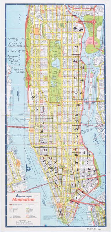
Still Image Hagstrom map of Manhattan : [Tenement House Committee Strong-holds of poverty and Prevalence of disease series index map]. View Item
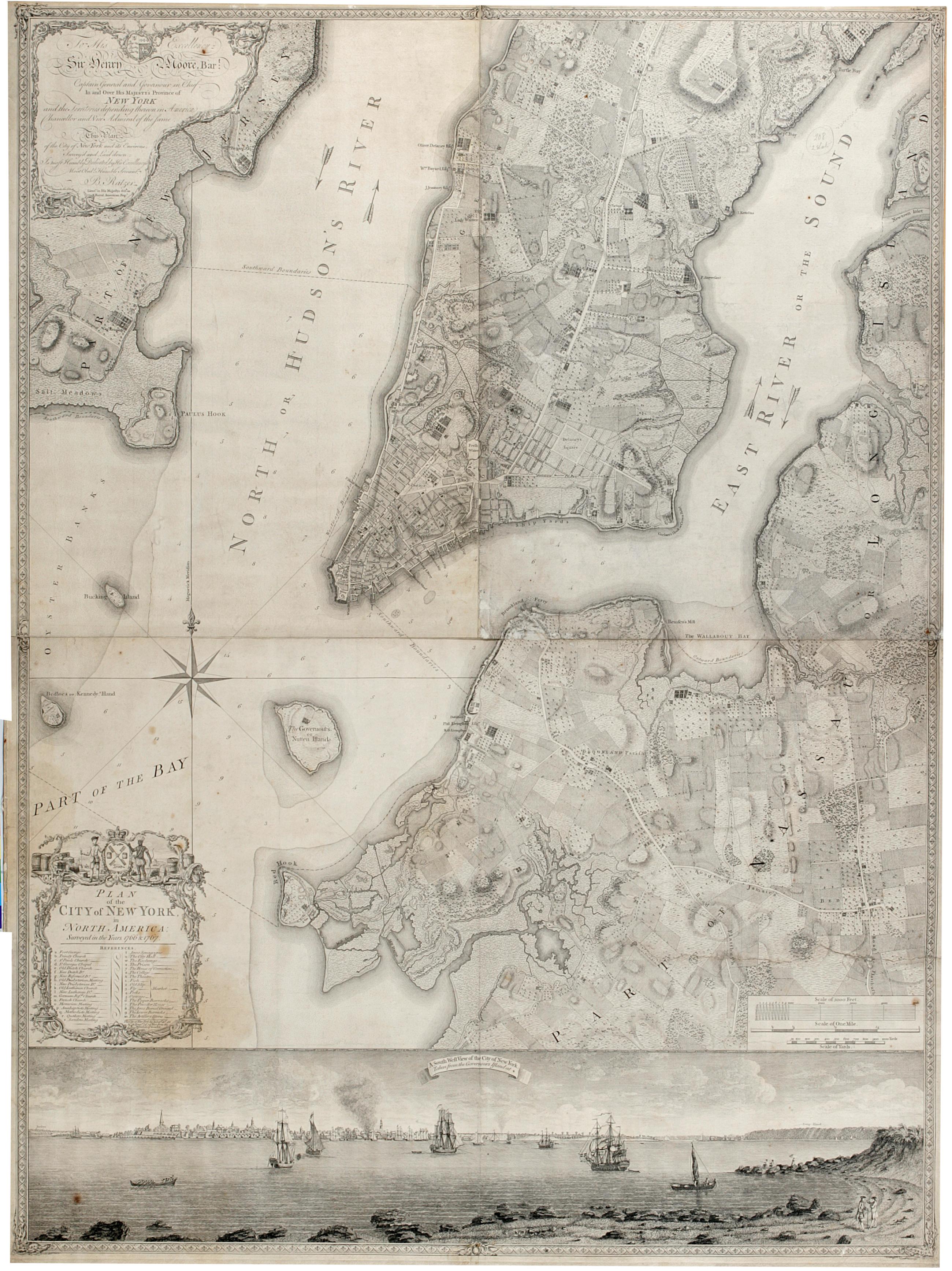
Still Image Plan of the city of New York in North America : surveyed in the years 1766 & 1767. The Ratzer map of New York City. First state, 1770. Covers part of modern New York City: Manhattan below the later 60th Street and Brooklyn north of the later 30th Street and west of the later Union Avenue; also a small part of modern Queens and of Jersey City, New Jersey. Shows built up and cultivated areas, streets and rural roads, some buildings, piers. Also shows streams, ponds and wetlands. Shows relief by hachures. Shows depths by soundings. Dedication at upper left: "To His Excellency Sir Henry Moore, Bart. View Item
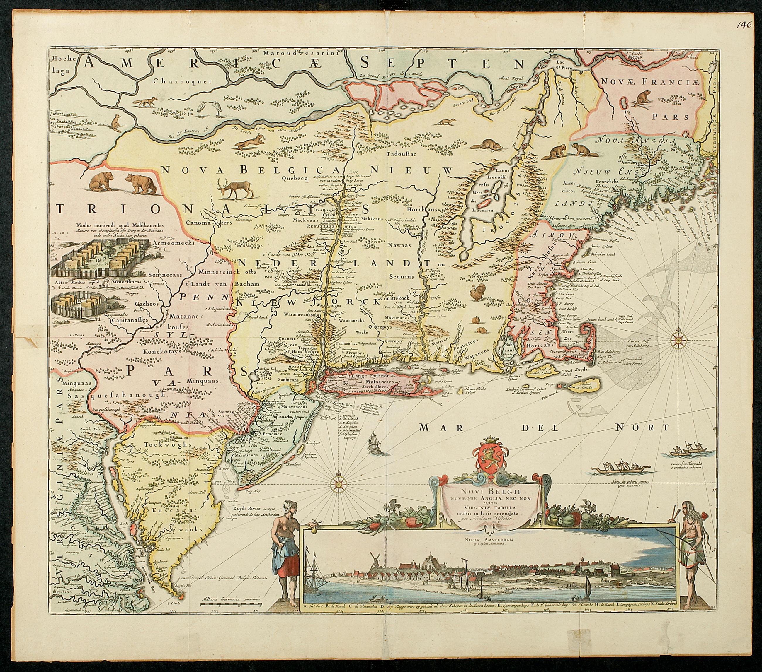
Still Image Novi Belgii, Novaeque Angliae nec non partis Virginiae tabula, [1655?] The maps of Nicolaes Visscher are among the famous descendants of the Jan Jansson map of circa 1651. The successive states of the engraving can be identified by minor changes made on the original plate. Of equal interest to the actual map, however, is the inset depicting "Nieuw Amsterdam op t Eylant Manhattans." This is the third engraved view of New Amsterdam; from the beginning it must have been considered important and attractive for it was frequently copied by other map-makers. View Item
Image Still Image 61 Items John Jacob Omenhausser's Rebel prison scenes, Point Lookout, Maryland, 1864 The forty-two color ink drawings presented here were made in 1864 by a Confederate prisoner of war at Point Lookout, Maryland, the Union's largest Civil War prison camp. The drawings highlight the concerns and experiences of prisoners of war; most scenes show prisoners playing cards, buying food, or engaging in barter with food vendors. All of the prison guards depicted are African American, and encounters are recorded between these guards and the Confederate prisoners. View Item