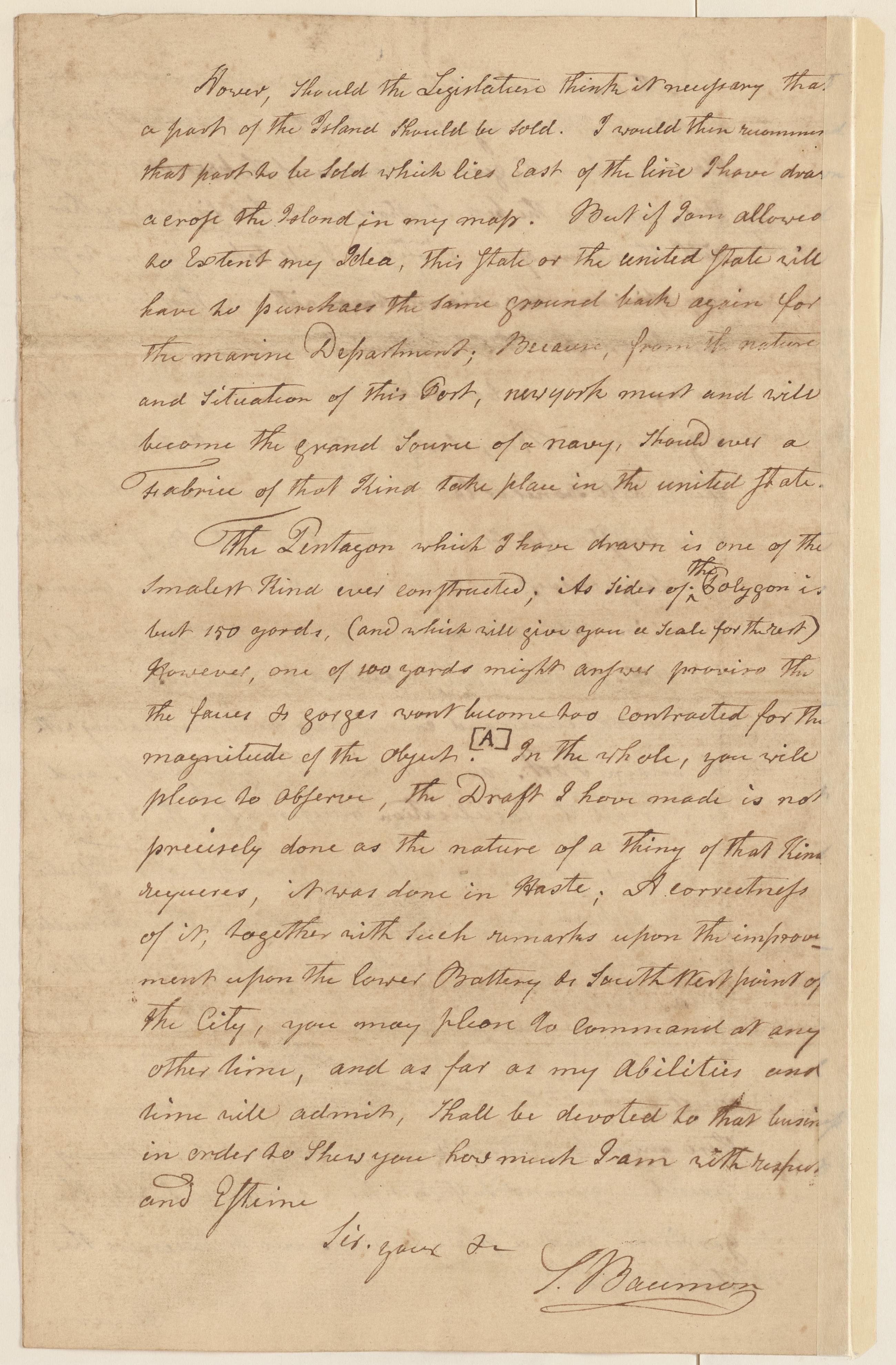
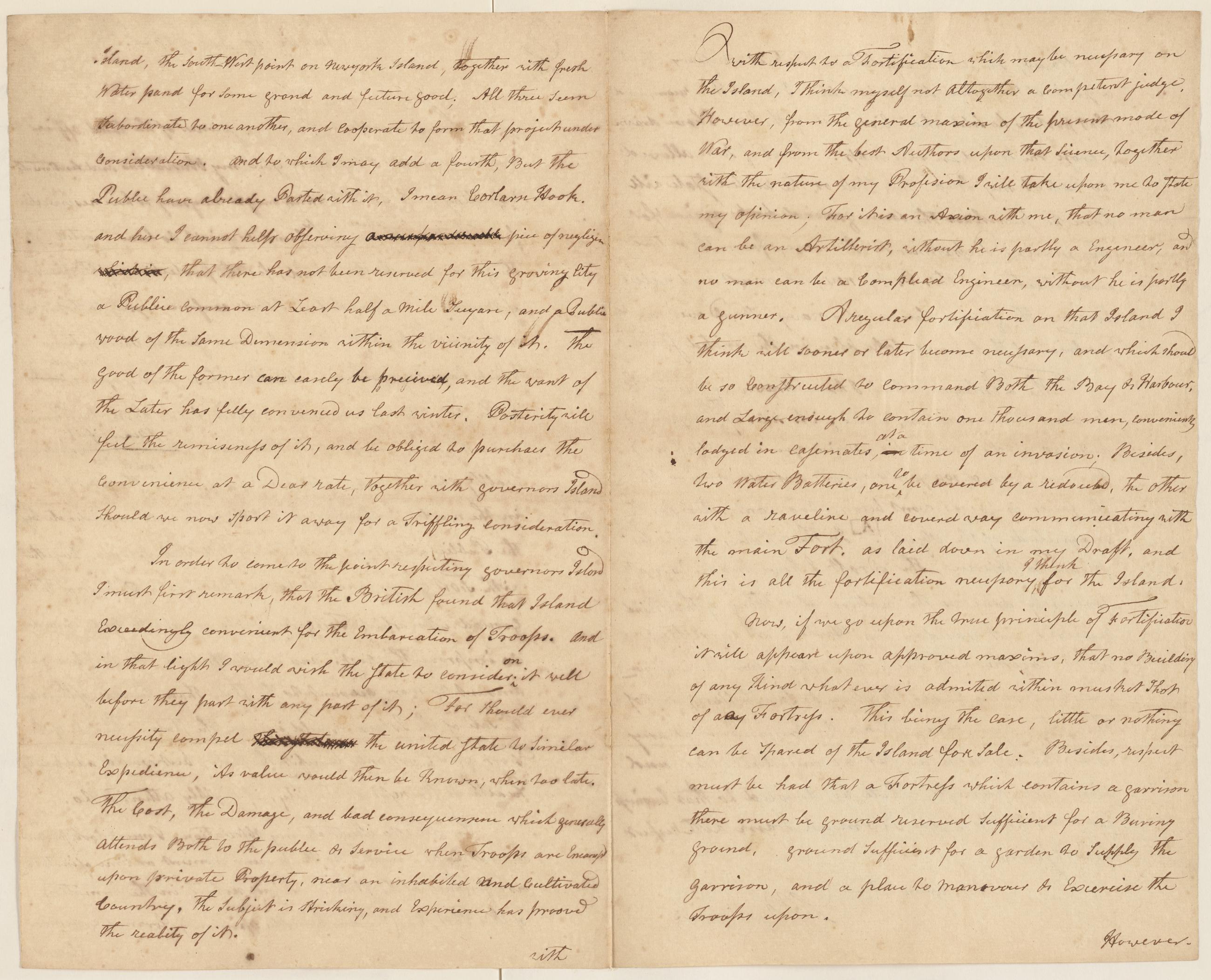
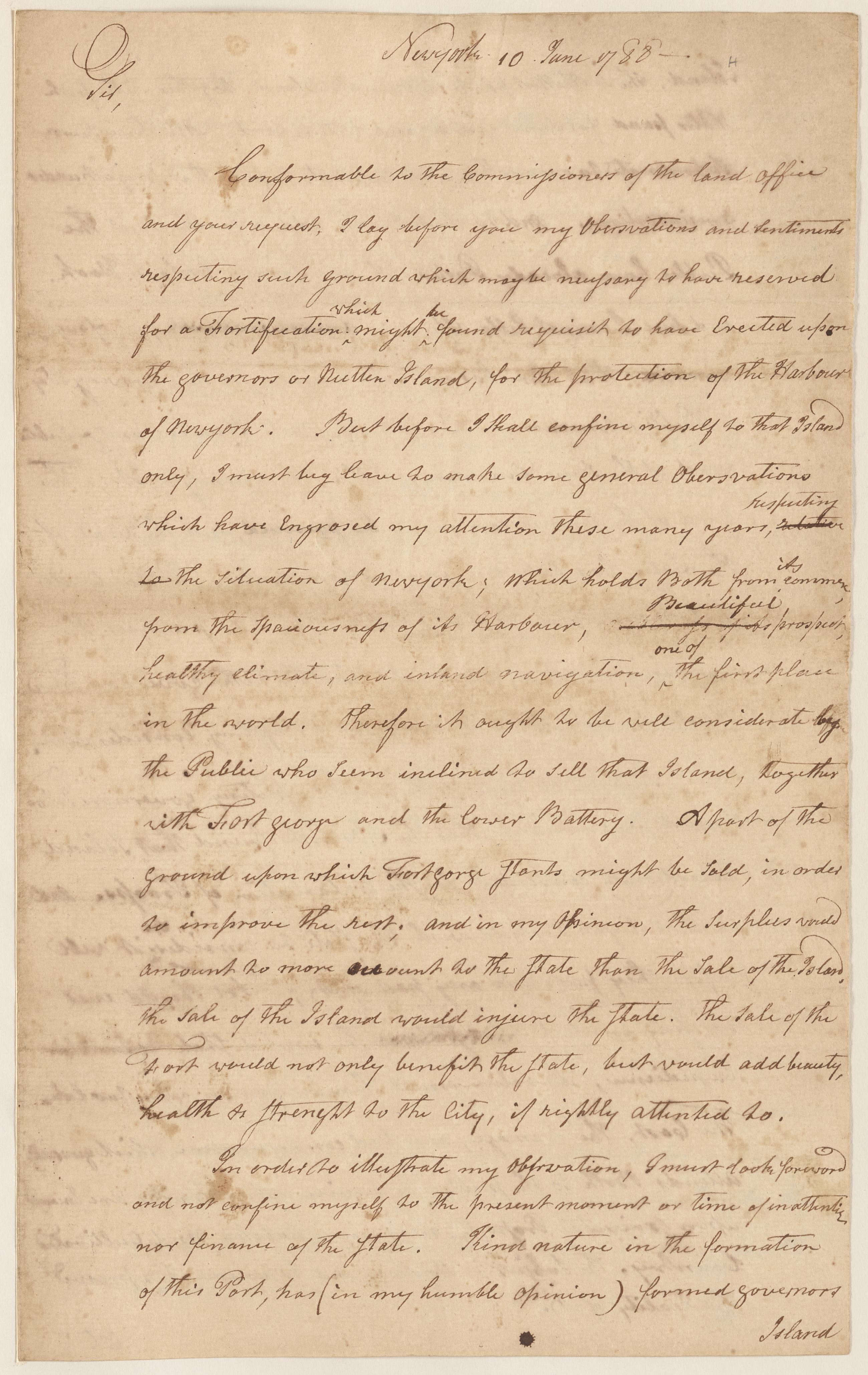
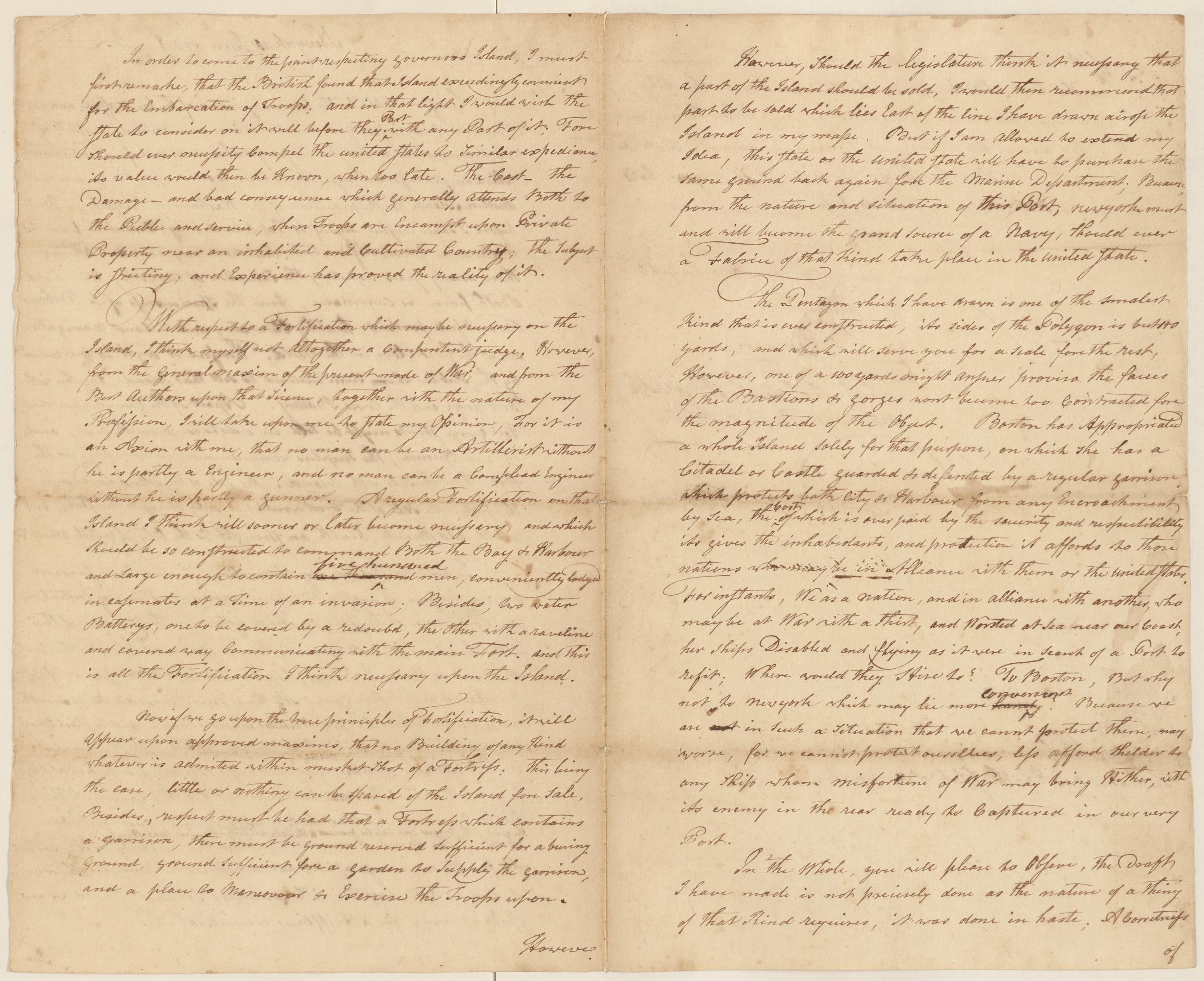
Image Text 3 Items Sebastian Bauman letter to Simeon De Witt, June 10, 1788 Copy of a letter from Sebastian Bauman addressed to Simeon De Witt, Surveyor General to the State of New York. "Observations and sentiment respecting such ground which may be necessary to have reserved for a Fortification which might be found requisit to have Erected upon the Governor or Nutten Island for the protection of the Harbour of New York". View Item
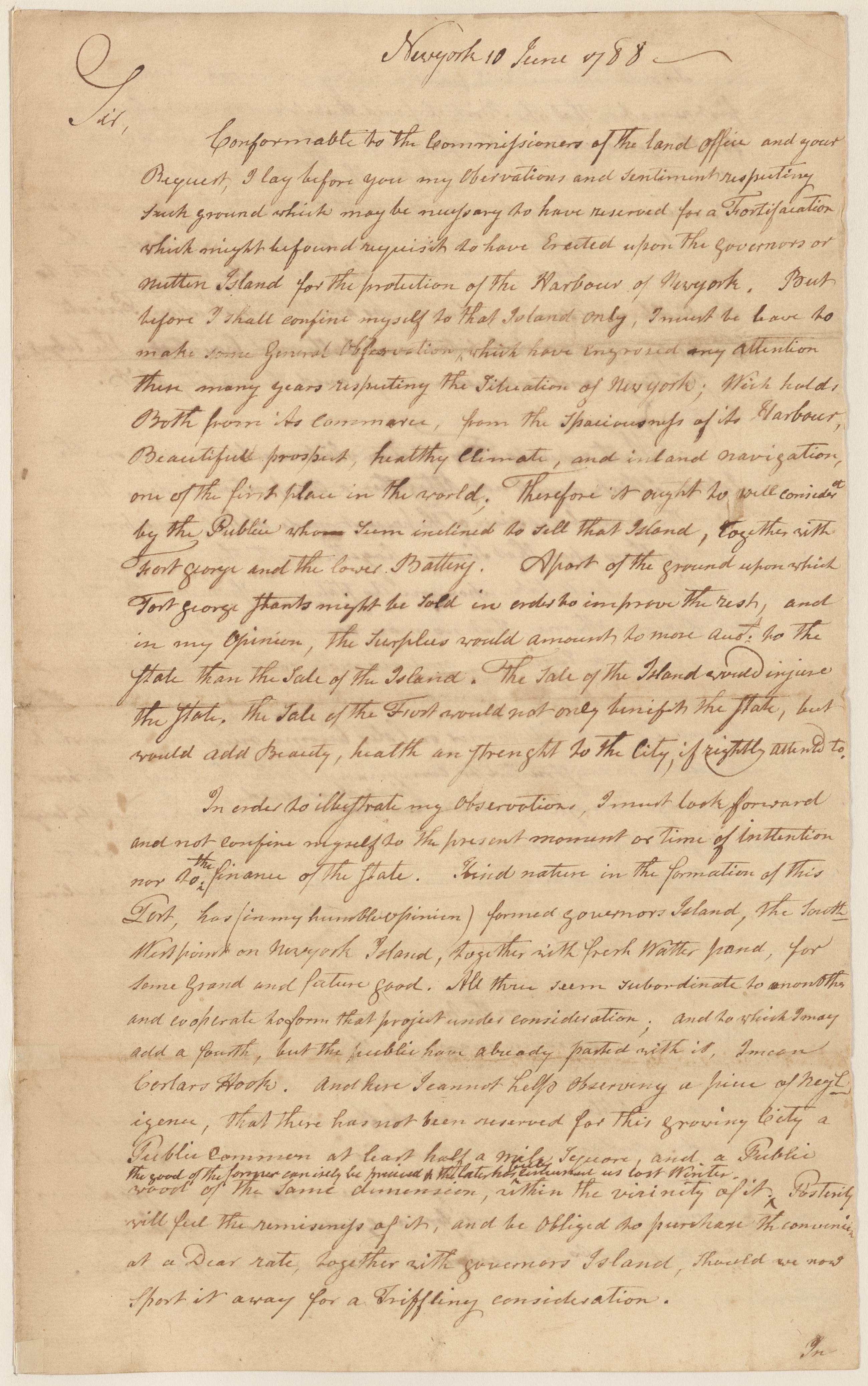
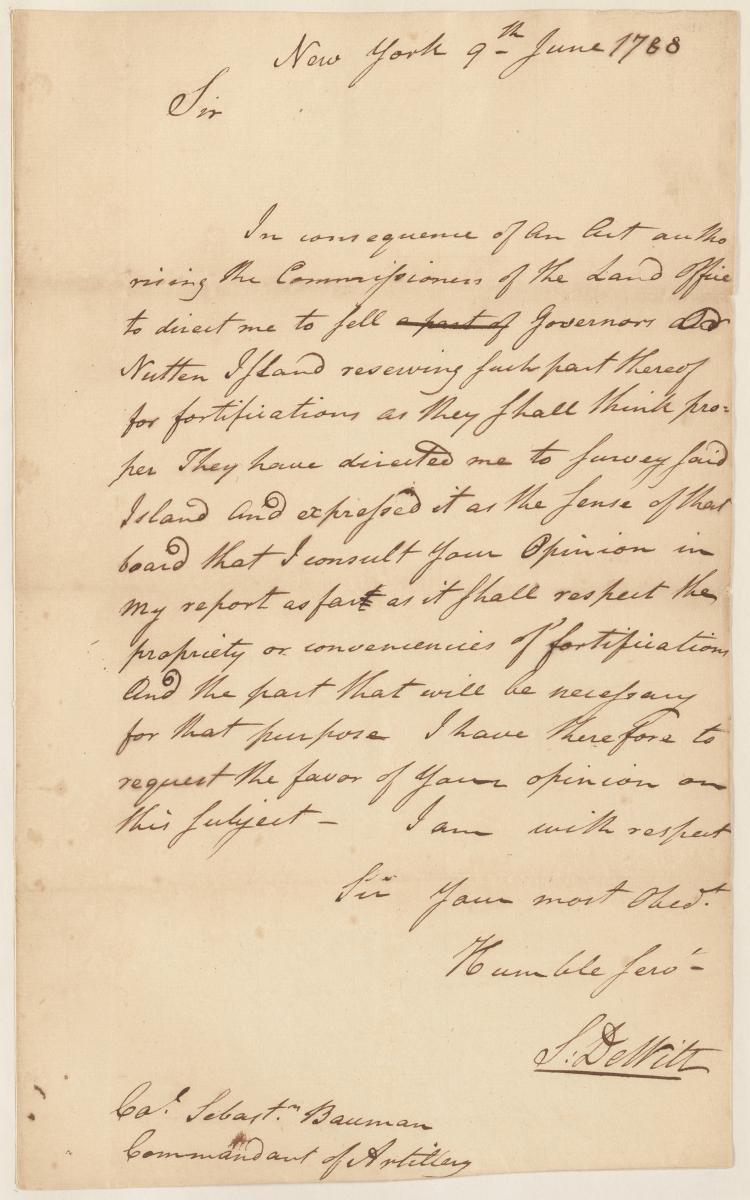
Image Text 3 Items Simeon De Witt letter to Sebastian Bauman, June 9, 1788 Asks his opinion on the subject of selling Governors or Nutten Island, and reserving parts thereof for fortifications. View Item
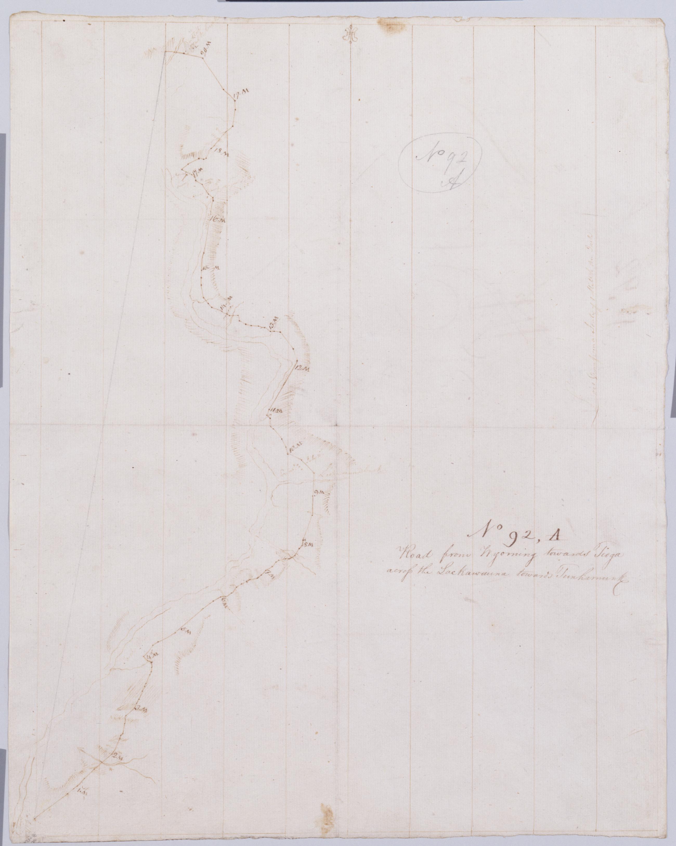
Cartographic Road from Wyoming towards Tioga across the Lackawauna towards Tunhamunk. No 92, A [sic]/ by Robert Erskine F.R.S. Geogr. A. U.S. and Assistants. Creased, foxed stained, soiled and abraded. Mounted on cloth, bound and cropped, disbound and silked by subsequent owners. Cleaned after removal of backings 1999; some fill remains. Sheathed in mylar. In pencil on recto and verso: "No 92 A". Military topographic map. Covers the counties of Lackawanna, Luzerne and Wyoming, Pennsylvania. Shows roads running through Wyoming Valley and Pittston. Also shows landforms and streams. Number accompanying verso title written in different ink. View Item
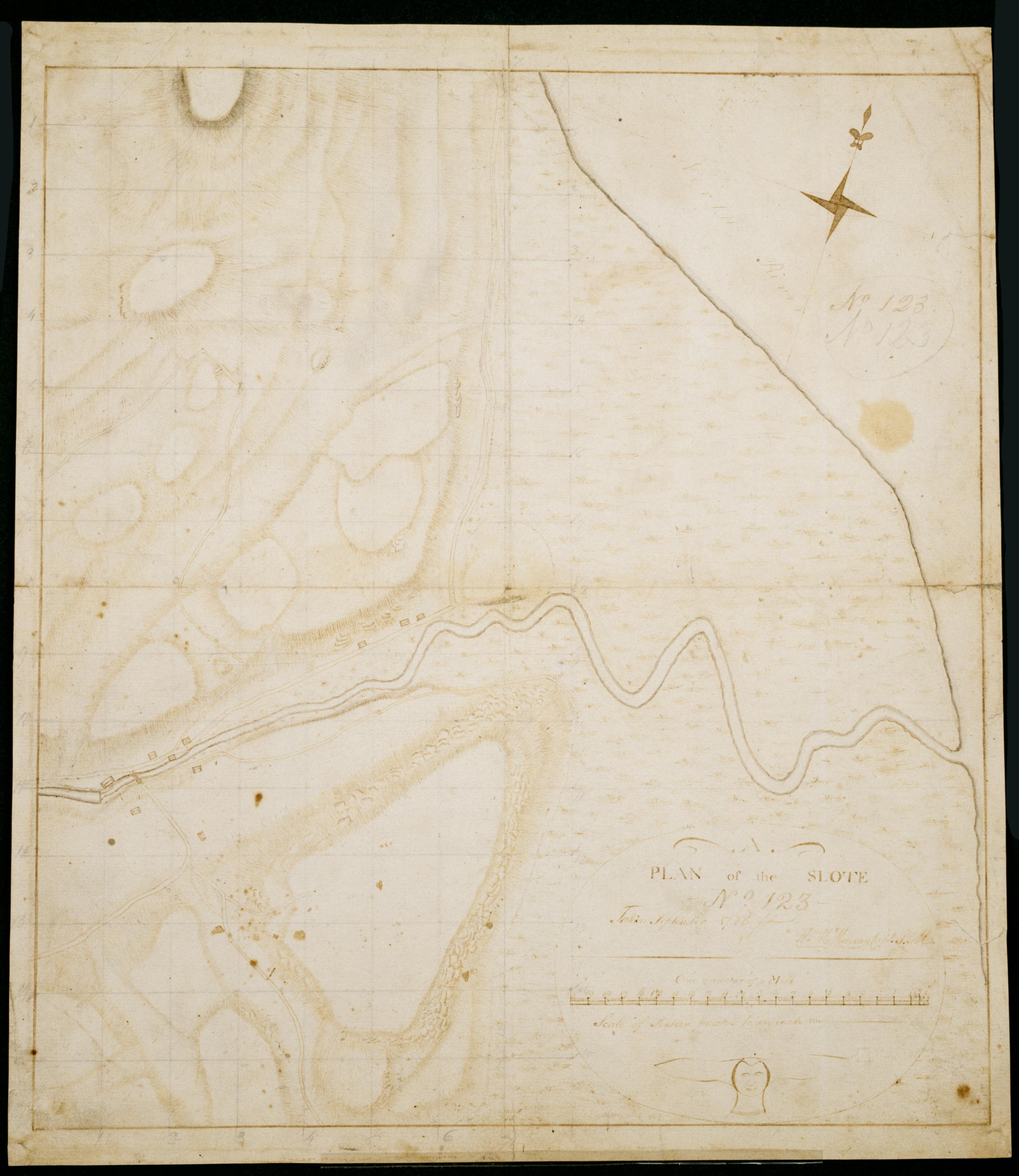
Cartographic Plan of the Slote No 123 / Taken September 1780 Wm. Mc'Murray Capt. P.M. ; by Robert Erskine F.R.S. Geogr. A. U.S. and Assistants. In both ink and pencil on recto: "No 123." Same text in ink on verso. Lengthy pencil text on verso illigible. Military topographic map. Covers the township of Orangetown in Rockland County, New York. Shows roads running through Piermont and Sparkill. Also shows buildings, landforms and streams. Original title proper and first statement of responsiblity from map recto. Index title, second statement of responsibility, series title and series numbering contemporaneous, but on separate index sheet filed at head of series. This sheet bears no title on map verso. Pen-and-ink, pencil on laid paper. View Item
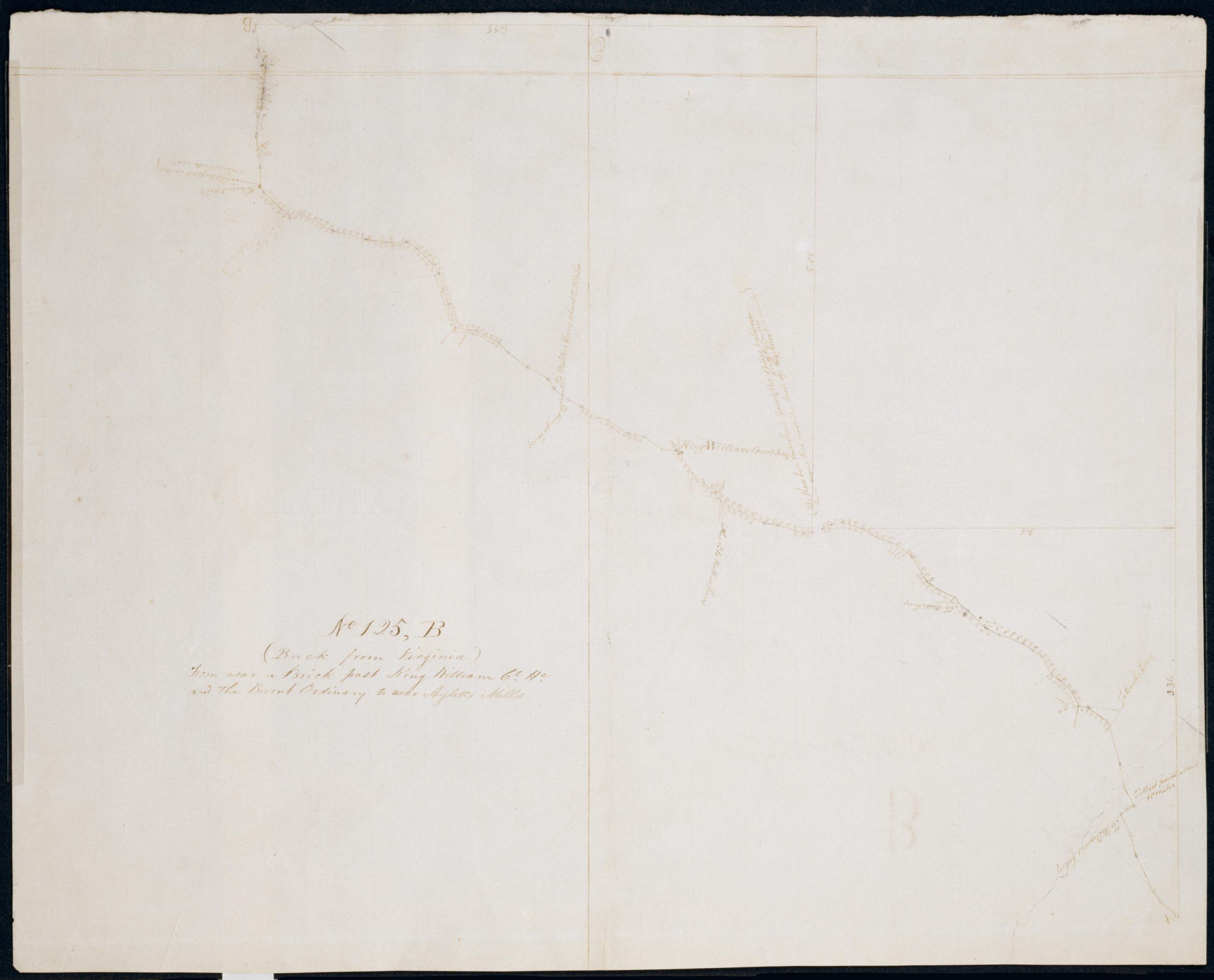
Cartographic From near a Brick past King William Ct. He. and the Burnt Ordinary to near Ayletts Mills. No 125, B / by Robert Erskine F.R.S. Geogr. A. U.S. and Assistants. Date inferred by cataloger. Foxed, creased, frayed and abraded. Mounted on cloth, bound and cropped, disbound and silked by subsequent owners. Cleaned after removal of backings 1999; some fill remains. Sheathed in mylar. In erased pencil on recto: "No 125 B". Military topographic map. Covers King William County in Virginia. Shows roads running through Rose Garden, King William, Rumford and Rosespout. Also shows buildings, landforms and streams. Pen-and-ink, pencil on laid paper. Shows relief by hachures. View Item
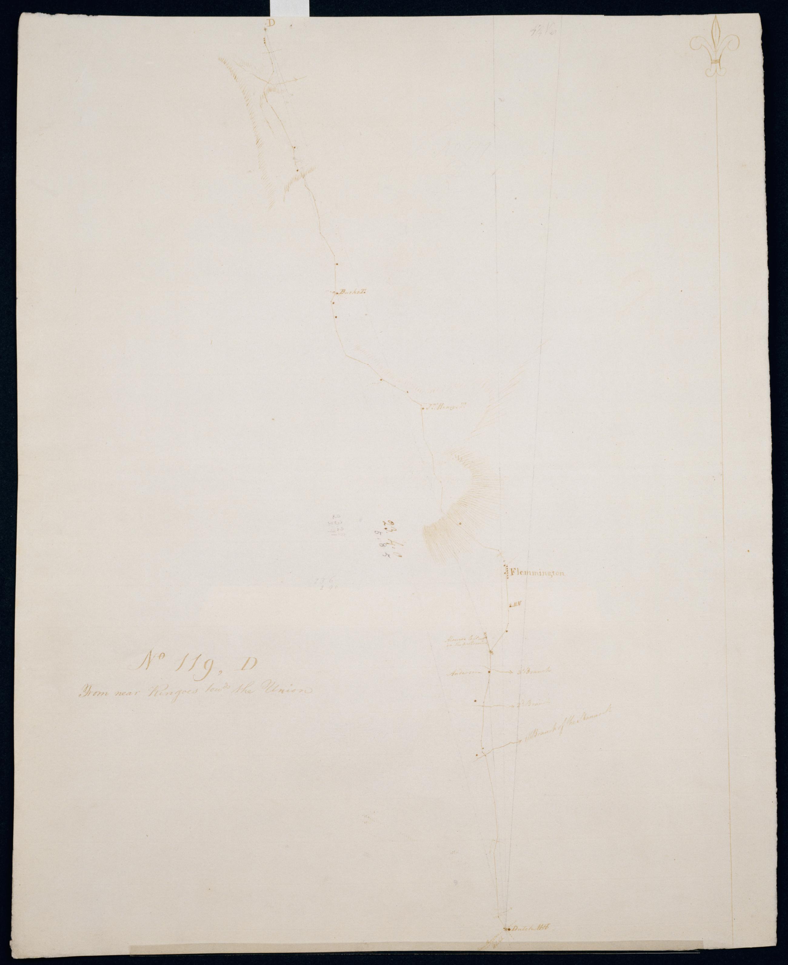
Cartographic From near Ringoes towds the Union. No 119, D / S DeWitt Geographer to the Army of the United States ; by Robert Erskine F.R.S. Geogr. A. U.S. and Assistants. Date of 1780 or 1781 based on verso text to sheet 119,F of series. First statement of responsibility from verso text on sheet 119,F of series. Military topographic map. Covers the townships of Raritan and Franklin in Hunterdon County, New Jersey. Shows roads running through Clinton, Sidney, Cherryville, Klinesville, Flemington, Copper Hill, Muirhead and Larison Corner. Also shows buildings and owners' names, landforms and streams. Pen-and-ink, pencil on laid paper. Shows relief by hachures. Stained, soiled , creased and abraded. View Item
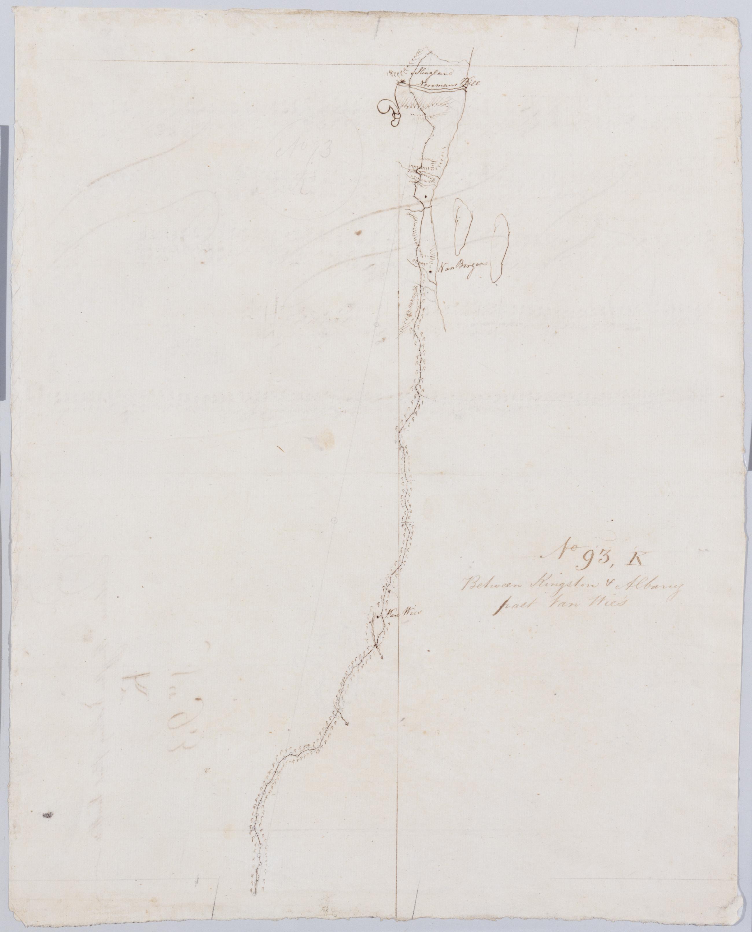
Cartographic Between Kingston + Albany past Van Wie's. No 93, K / by Robert Erskine F.R.S. Geogr. A. U.S. and Assistants. Foxed, stained, soiled, creased and abraded. Mounted on cloth, bound and cropped, disbound and silked by subsequent owners. Cleaned after removal of backings 1999; some fill remains. Sheathed in mylar. In ink on verso: "K K K". In pencil on recto: "No 93 K". Military topographic map. Covers the townships of Coeyman and Bethlehem in Albany County, New York. Shows roads running through Cedar Hill and Glenmont. Also shows buildings and owners' names, landforms and streams. Pen-and-ink, pencil on laid paper. Shows relief by hachures. View Item
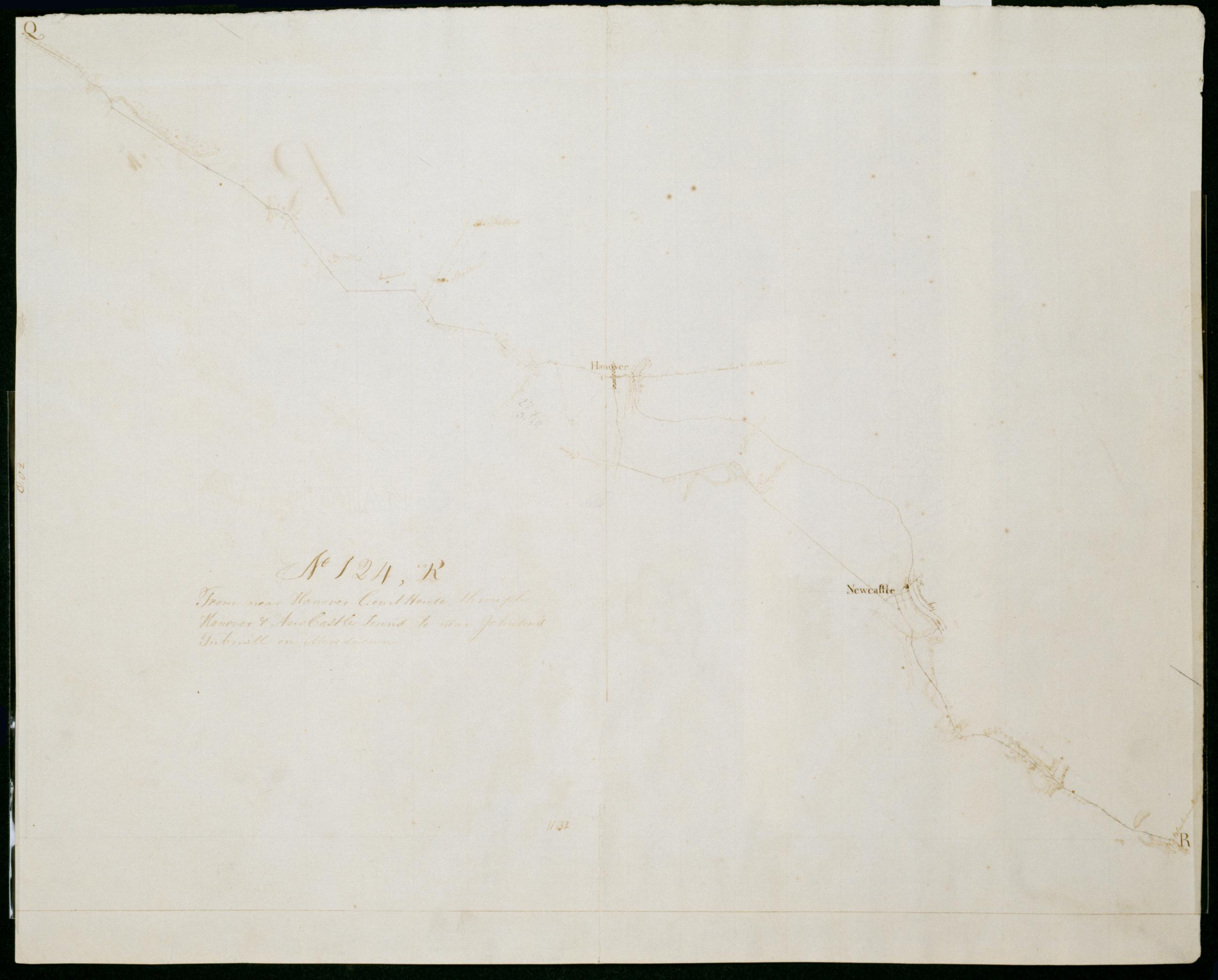
Cartographic From near Hanover Court House through Hanover + New Castle Towns to near Johnson's Tubmill on Mere de cum. No 124, R / by Robert Erskine F.R.S. Geogr. A. U.S. and Assistants. Date 1781 inferred by cataloger. Foxed, soiled, creased and abraded. Mounted on cloth, bound and cropped, disbound and silked by subsequent owners. Cleaned after removal of backings 1999; some fill remains. Sheathed in mylar. Military topographic map. Covers Hanover County in Virginia. Shows roads running through Cady, Hanovertown and Eastern View. Also shows buildings, landforms and streams. Pen-and-ink, pencil on laid paper. Shows relief by hachures. Title proper from recto is the work of a later editor--Simeon DeWitt or his assign--subsequent to 1820. View Item
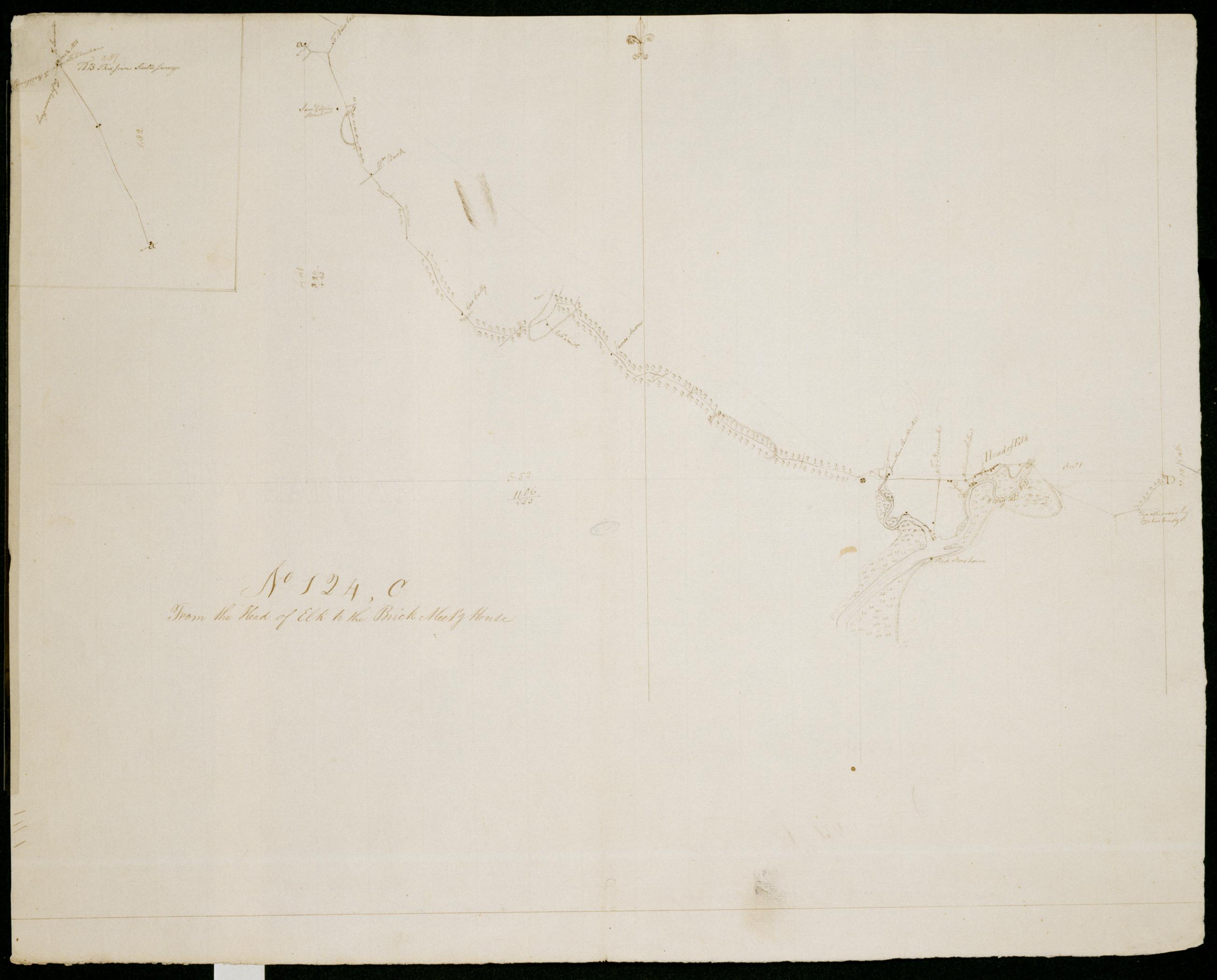
Cartographic From the Head of Elk to the Brick Meet'g House. No 124, C / by Robert Erskine F.R.S. Geogr. A. U.S. and Assistants. Continuation of main map in inset includes text: "NB This joins with Sculls surveys." Indeed, this entire sheet is a spur towards Lancaster, Pennslyvania continguous with maps 130,1st and 130,2nd. For the continuation of 124,B, see 124,D. Date 1781 inferred by cataloger. Military topographic map. Covers Cecil County, Maryland. Shows roads running through Elkton, Eder, Mechanic Valley and Calvert. Also shows buildings and owners' names, landforms and streams. Pen-and-ink, pencil on laid paper. Shows relief by hachures. Stained, soiled, creased and abraded. View Item
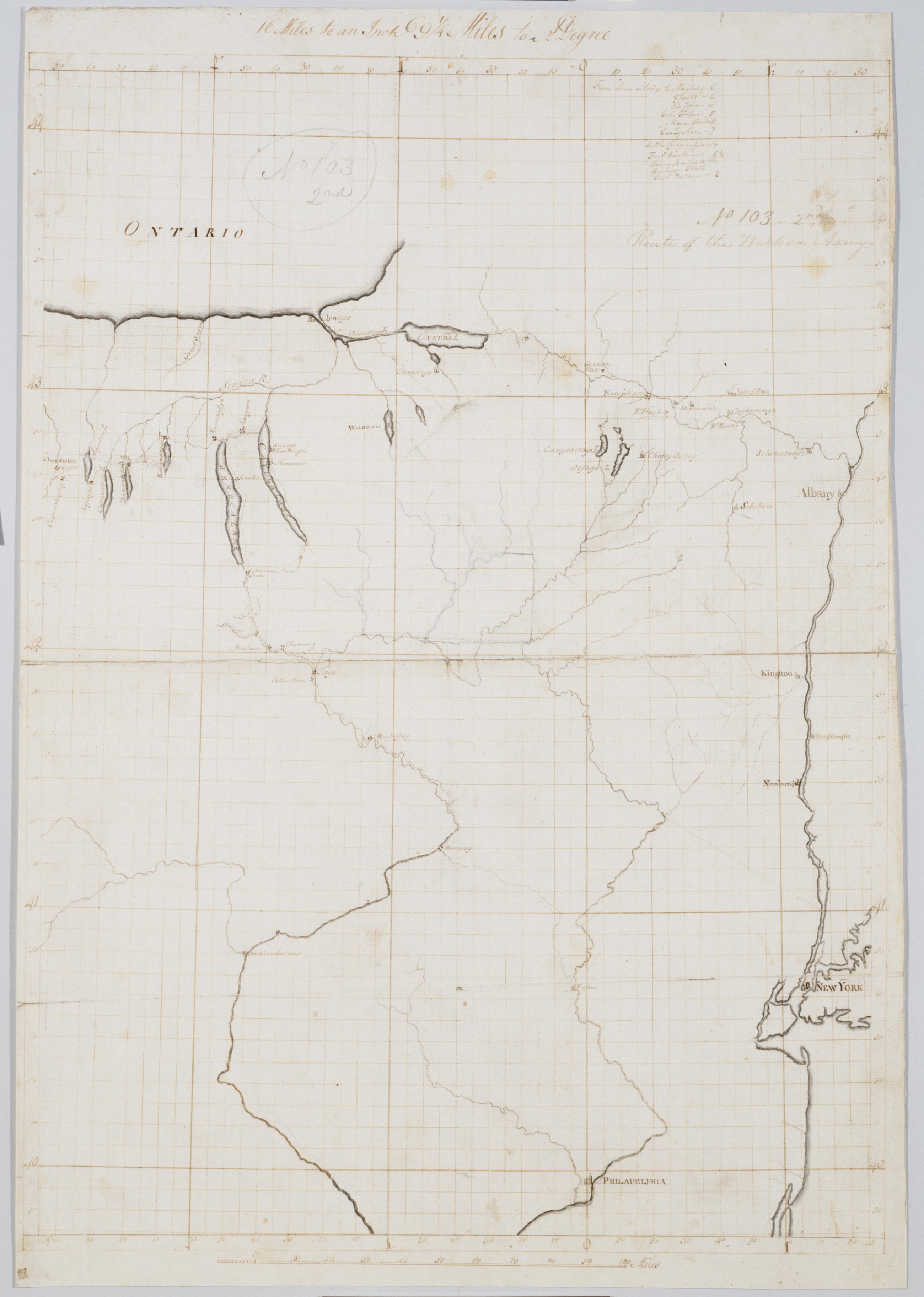
Cartographic Route of the Western Army. No 103-2nd [i.e., No. 101-4th] by R.E. ; by Robert Erskine F.R.S. Geogr. A. U.S. and Assistants. In pencil on recto: "No 103 2nd" and on verso "No: 103." Military topographical map. Covers parts of New York, Pennsylvania and New Jersey. Pen-and-ink, pencil on laid paper. Sheet carries no title on verso. Shows relief by hachures. Soiled, stained, creased and abraded. Mounted on cloth, bound and cropped, disbound and silked by subsequent owners. Cleaned after removal of backings 1999; some fill remains. Sheathed in mylar. Title proper from recto is the work of a later editor--Simeon DeWitt or his assign--subsequent to 1820. View Item
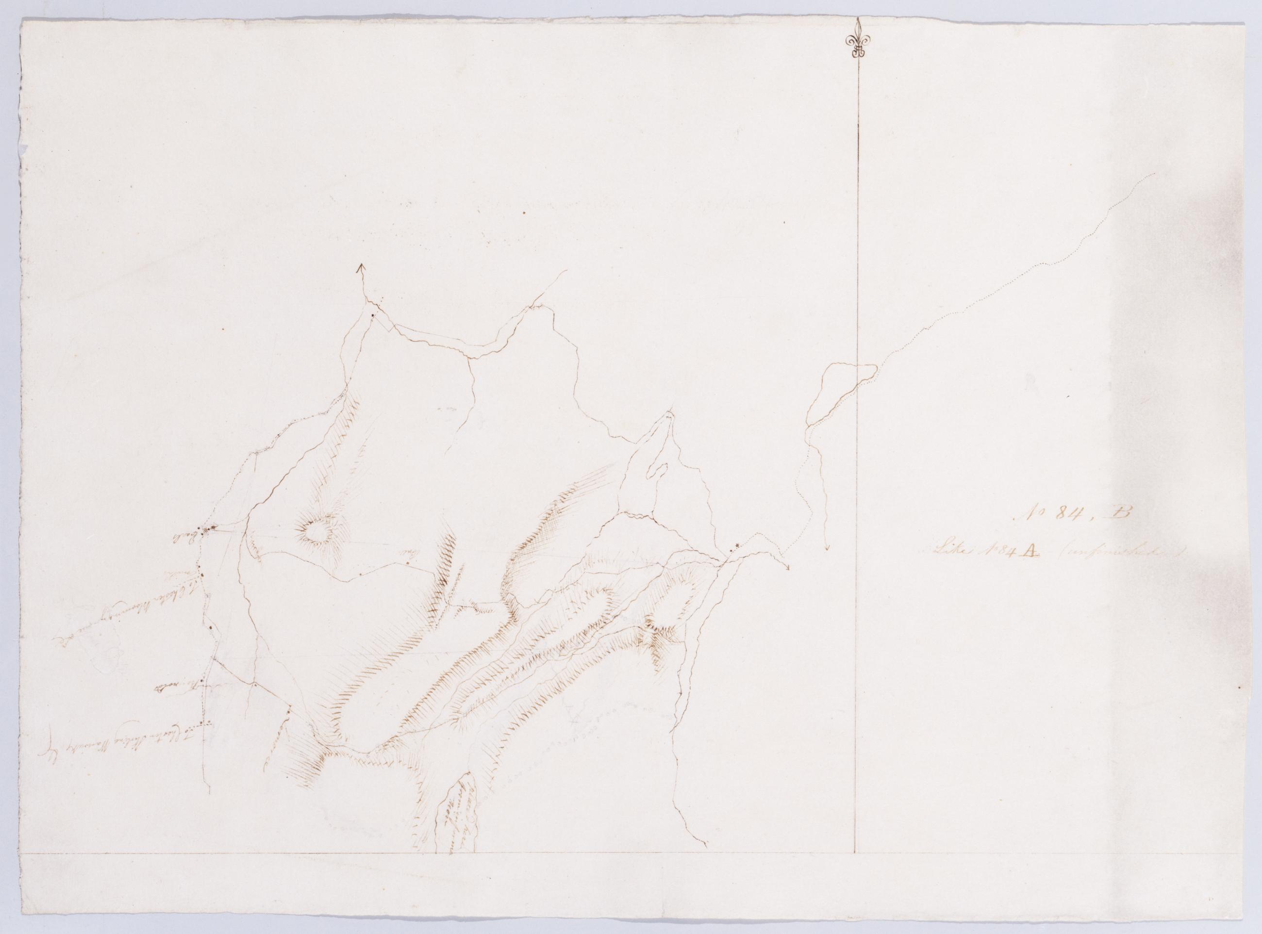
Cartographic Like No 84 A (unfinished) No 84, B / by Robert Erskine F.R.S. Geogr. A. U.S. and Assistants. In ink on verso: "No. 84. B." Military topographic map. Covers the townships of Highland and Woodbury in Orange County, New York. Shows more land to the west than does sheet 84,A. Also shows roads, buildings and owners' names, also landforms and streams. Pen-and-ink, pencil on laid paper. Shows relief by hachures. Soiled and abraded. Mounted on cloth, bound, disbound and silked by subsequent owners. Cleaned after removal of backings 1999; some fill remains. Sheathed in mylar. Title proper from recto is the work of a later editor--Simeon DeWitt or his assign--subsequent to 1820. View Item
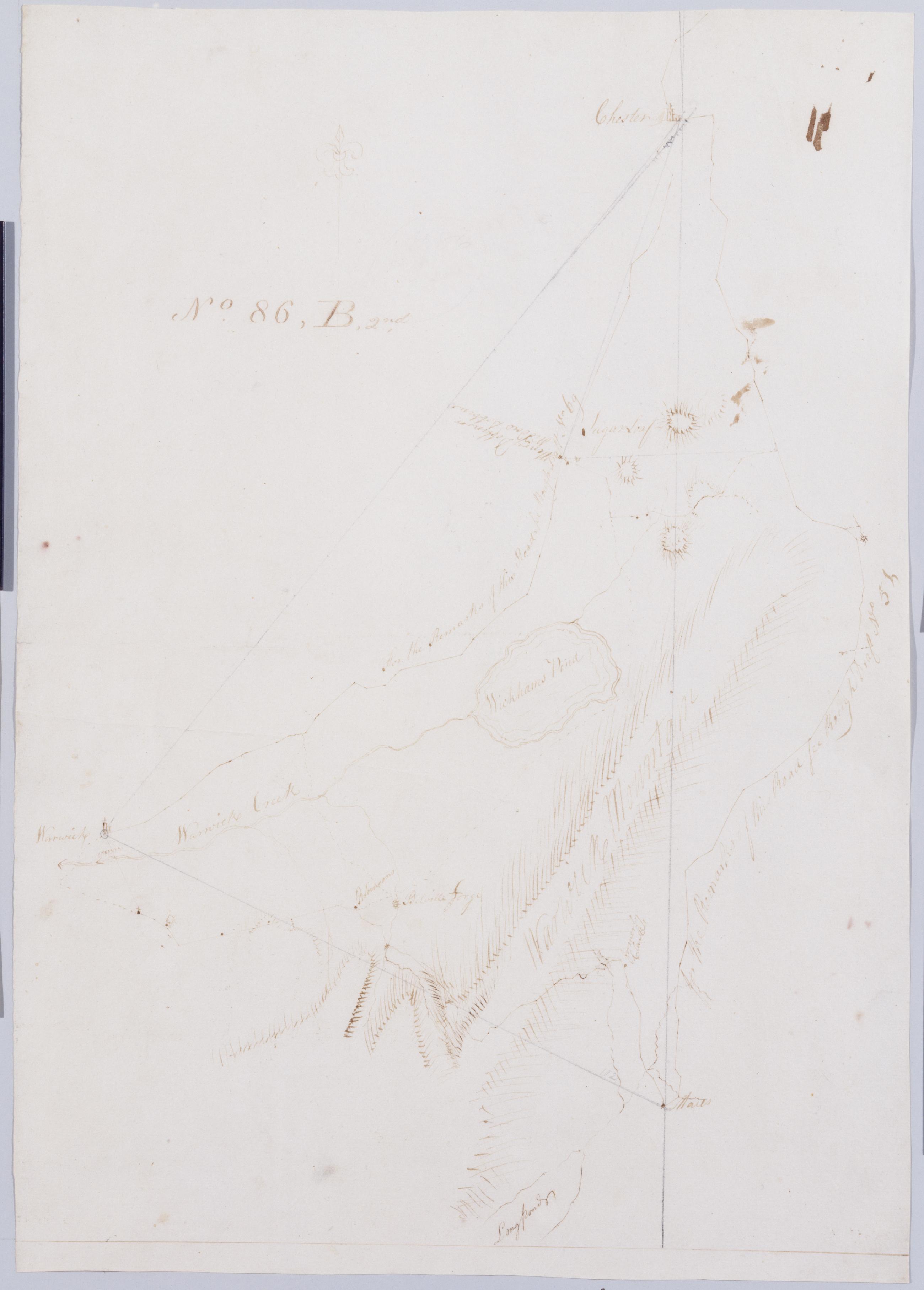
Cartographic From Junes to Arches & Warwich A. B & B2nd. No 86, B, 2nd by Robert Erskine F.R.S. Geogr. A. U.S. and Assistants [rev. ed.]. In ink on recto: "No. 86. B2d". Includes texts. To the east, "for the Remarks of the Road see Rough Draft No 5[1]." To the west, "For the Remarks of this Road See Rough Draft No 69." Military topographic map. Covers the townships of Chester and Warwick in Orange County, New York. Shows roads running through East Chester, Sugarloaf, Warwick, Bellvale, Mt. Peter and Dutch Hollow. Also shows buildings and owners' names, landforms and streams. No title on map recto or verso. View Item
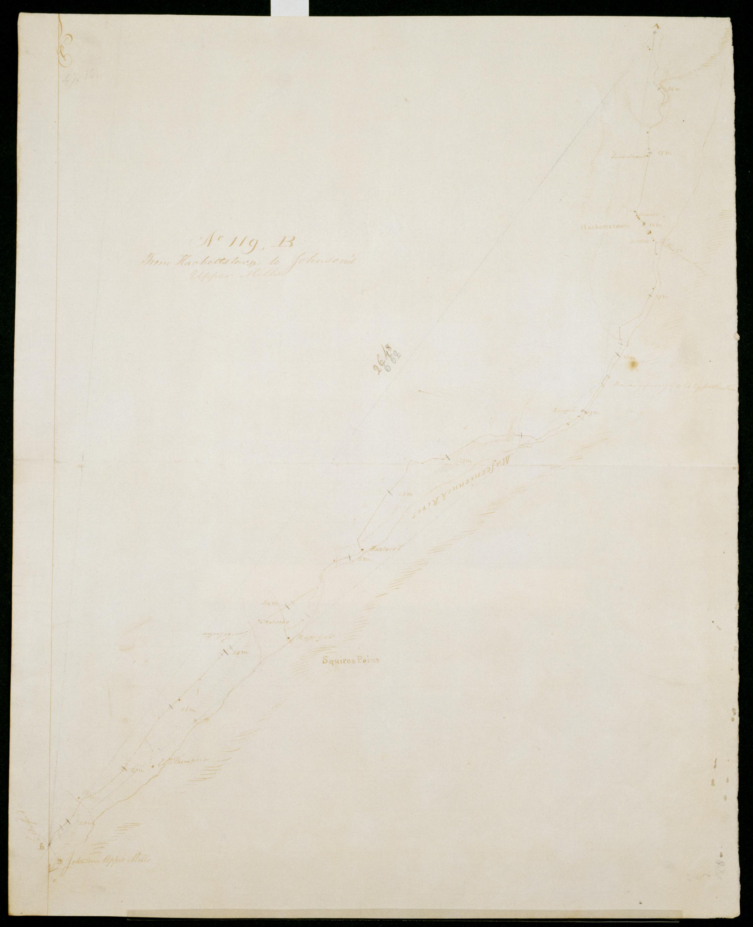
Cartographic From Hackettstown to Johnson's Upper Mills. No 119, B / S DeWitt Geographer to the Army of the United States ; by Robert Erskine F.R.S. Geogr. A. U.S. and Assistants. Date of 1780 or 1781 based on verso text to sheet 119,F of series. First statement of responsibility from verso text on sheet 119,F of series. In erased pencil on recto: "No 119 ..." Military topographic map. Covers the townships of Allamuchy, Independence, Mansfield and Washington in Warren County, New Jersey. Shows roads running through Hackettstown, Beatyestown, Penwell and Anderson. Also shows buildings and owners' names, landforms and streams. Pen-and-ink, pencil on laid paper. Shows relief by hachures. Stained, soiled , creased and abraded. View Item
Cartographic Road from near the 14 M. S. from Burlington thro' Moorstown & Mount Holly to one James Sippingwill's. No 87, F / by Robert Erskine F.R.S. Geogr. A. U.S. and Assistants. In ink on verso: "No. 87 F." In pencil on recto: "No 87 F". Military topographic map. Covers the townships of Northampton, Lumberton, Mount Laurel, Chester and Cinnaminson in Burlington County and of Pensauken in Camden County, New Jersey. Shows roads running through Morrisville, Parry, New Albany, Union Mills, Hainesport and Mount Holly. Also shows buildings and owners' names, landforms and streams. Pen-and-ink, pencil on laid paper. Shows relief by hachures. Soiled, foxed, creased, frayed and abraded. Mounted on cloth, cropped, bound, disbound and silked by subsequent owners. View Item
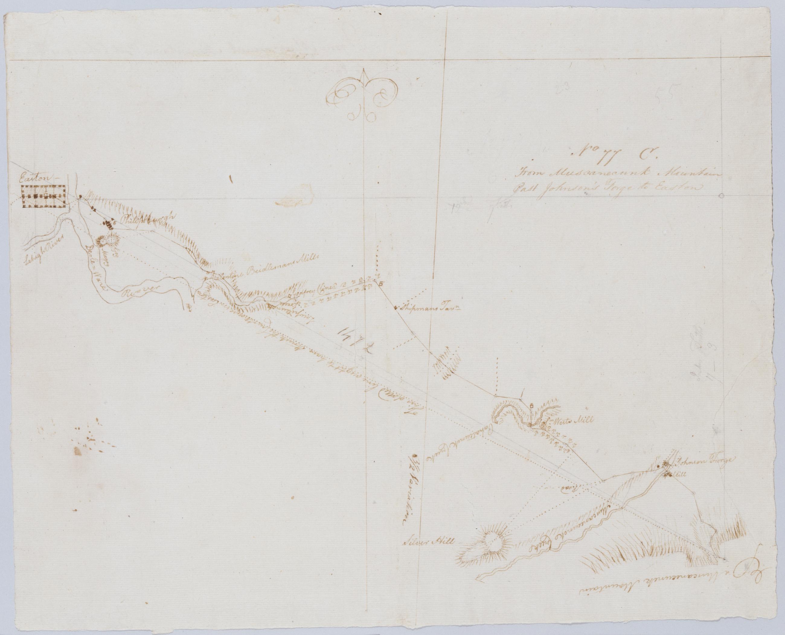
Cartographic From Muscanecunk Mountain Past Johnson's Forge to Easton. No 77 C / by Robert Erskine F.R.S. Geogr. A. U.S. and Assistants. In erased pencil on recto: "No 77 C". Military topographic map. Covers the townships of Greenwich and Pohatcong in Warren County and of Bethlehem in Hunterdon County, New Jersey; also covers part of Berks County, Pennsylvania. Shows roads running through Bloomsbury, Kennedy Mills, Still Valley and Phillipsburg in New Jersey as well as Easton, Pennsylvania. Also shows buildings and owners' names, landforms and streams. Pen-and-ink, pencil on laid paper. Shows relief by hachures. Title proper from recto is the work of a later editor--Simeon DeWitt or his assign--subsequent to 1820. View Item
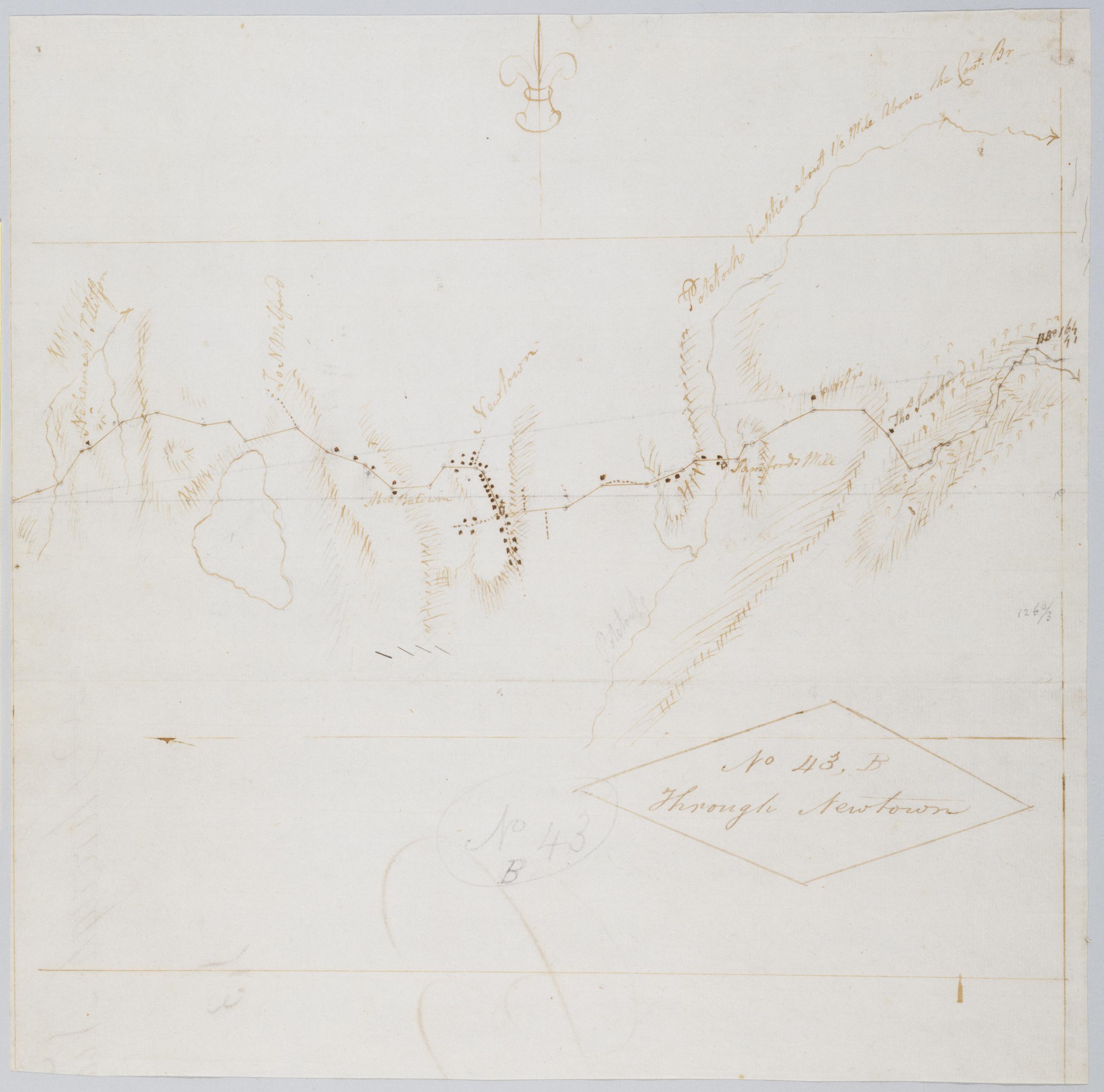
Cartographic Through Newtown. No 43, B / by Robert Erskine F.R.S. Geogr. A. U.S. and Assistants. Foxed, creased, frayed, and abraded. Mounted on cloth, bound and cropped, disbound and silked by subsequent owners. Cleaned after removal of backings 1999; some fill remains. Sheathed in mylar. In pencil on recto: "No 43 B". Military topographic map. Covers the township of Newtown in Fairfield County, Connecticut. Shows roads running through Sandy Hook and Newtown. Also shows buildings and owners' names, landforms and streams. Pen-and-ink, pencil on laid paper. Shows relief by hachures. Title proper from recto is the work of a later editor--Simeon DeWitt or his assign--subsequent to 1820. View Item
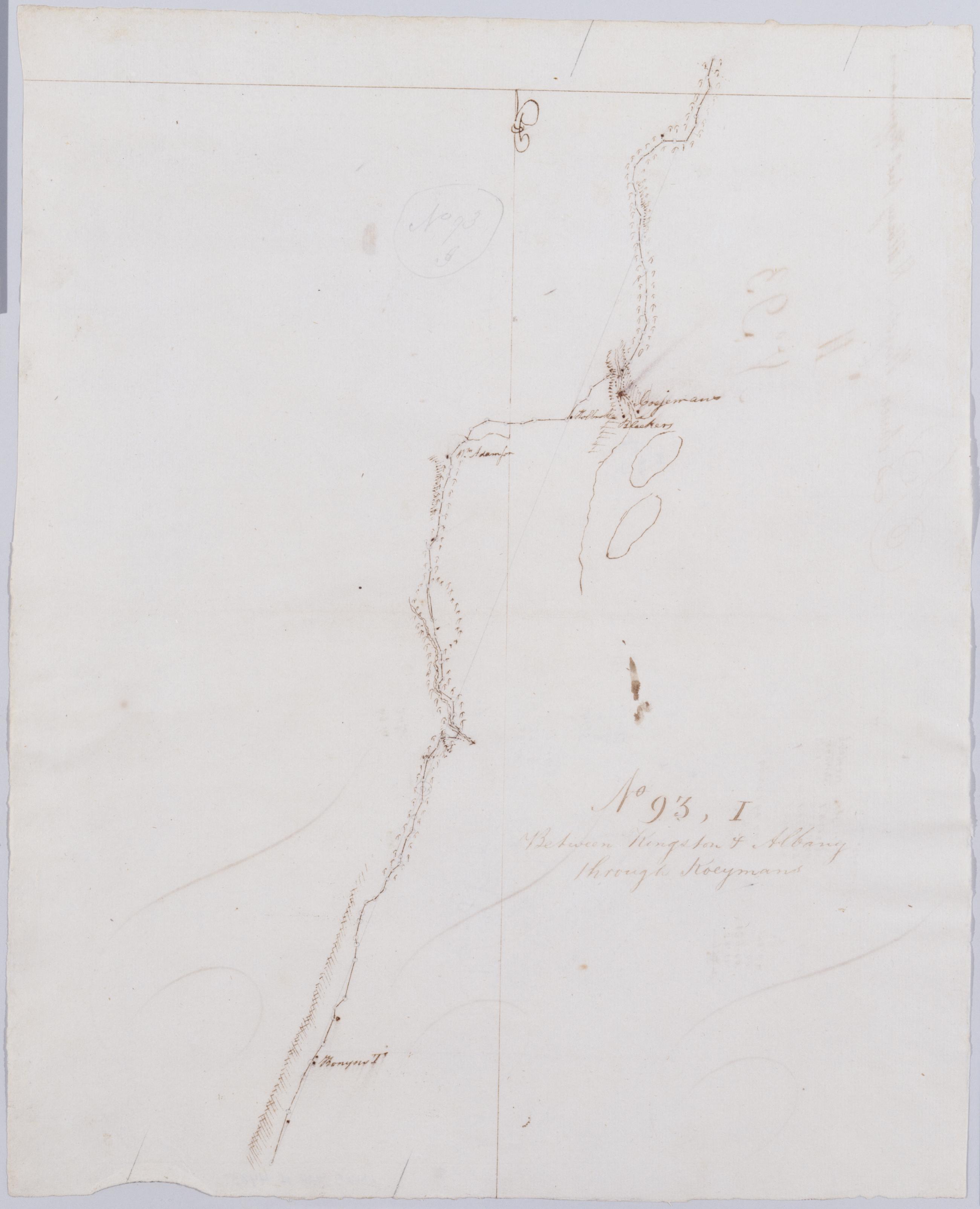
Cartographic Between Kingston + Albany thro' Koeymans. No 93, I / by Robert Erskine F.R.S. Geogr. A. U.S. and Assistants. Foxed, stained, creased and abraded. Mounted on cloth, bound and cropped, disbound and silked by subsequent owners. Cleaned after removal of backings 1999; some fill remains. Sheathed in mylar. In ink on verso: "I I I". In pencil on recto: "No 93 I". Military topographic map. Covers the townships of New Baltimore in Green County and of Coeyman in Albany County, New York. Shows roads running through Ravena and Coeyman. Also shows buildings and owners' names, landforms and streams. Pen-and-ink, pencil on laid paper. Shows relief by hachures. View Item
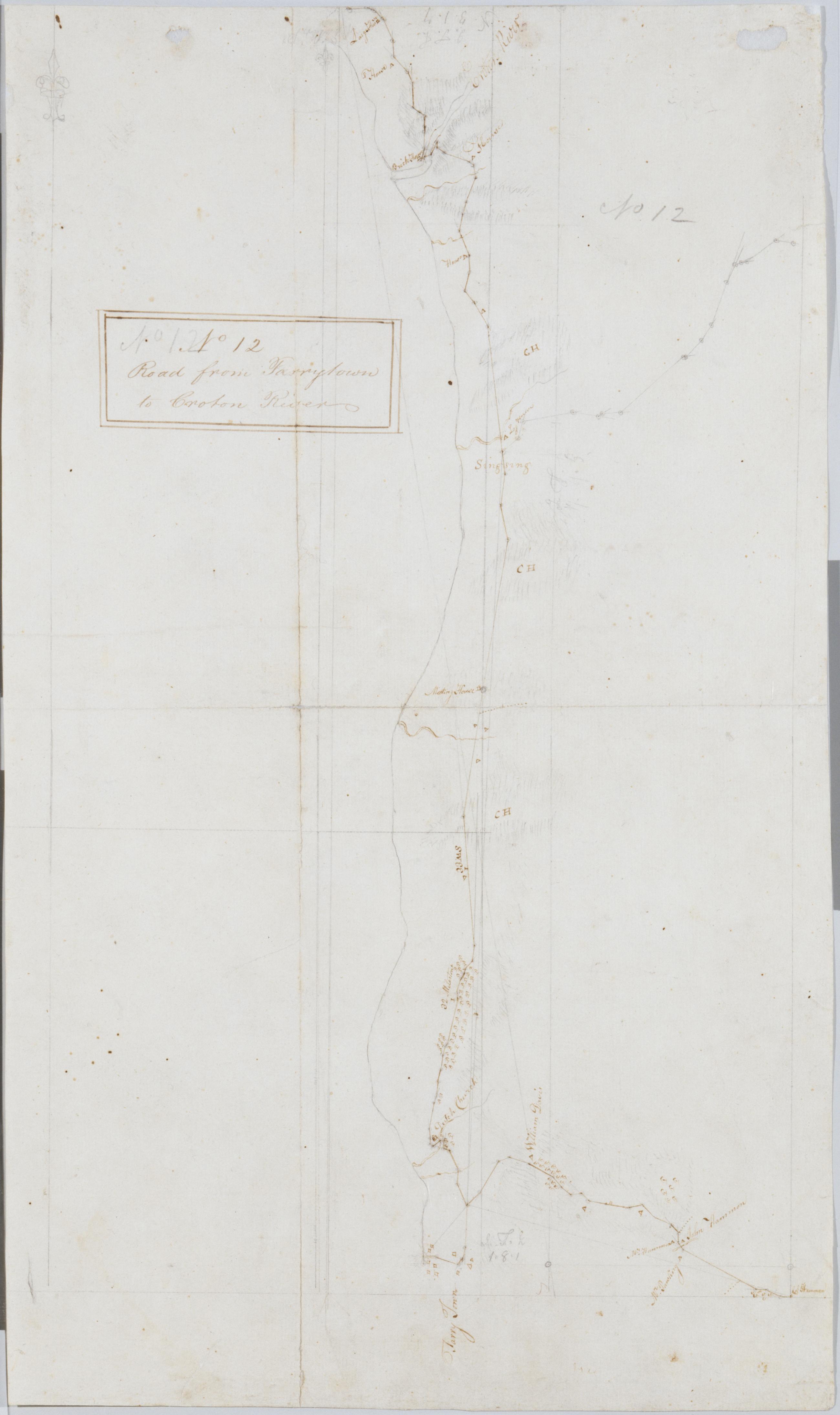
Cartographic Road from Tarrytown to Croton River. No 12 / by Robert Erskine F.R.S. Geogr. A. U.S. and Assistants. Foxed, creased, frayed and abraded. Mounted on cloth, bound and cropped, disbound and silked by subsequent owners. Cleaned after removal of backings 1999; some fill remains. Sheathed in mylar. Military topographic map. Covers the towns of Mt. Pleasant, Ossining and Cortlandt on the left bank of the Hudson River in Westchester County, New York. Shows roads running through Eastview, Tarrytown, Ossining and Croton. Also shows buildings and owners' names, landforms and streams. Pen-and-ink, pencil on laid paper. Shows relief by hachures. View Item
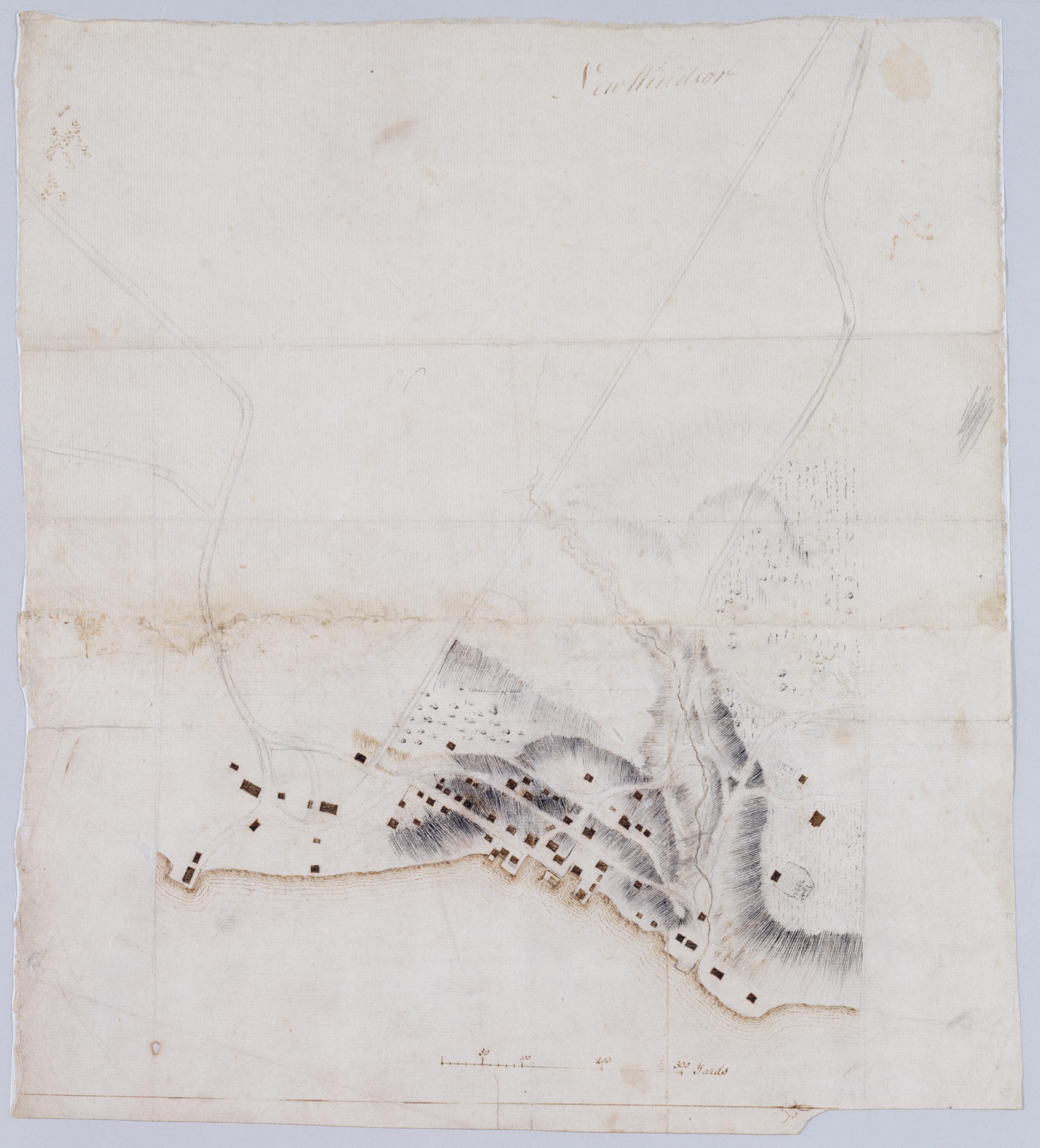
Cartographic New Windsor. In pencil on verso: "for F De Peyster Esq." DePeyster was a 19th century official of the New York Historical Society. Military topographic map. Covers the village of New Windsor and surrounding area in the town of New Windsor, Orange County, New York. Shows roads, buildings and landforms. Pen-and-ink, pencil on laid paper. Shows relief by hachures. Soiled and stained, creased, frayed and abraded. Mounted on cloth, bound and cropped, disbound and silked by subsequent owners. Cleaned after removal of backings 1999; some fill remains. Re-lined with China paper. Sheathed in mylar. View Item
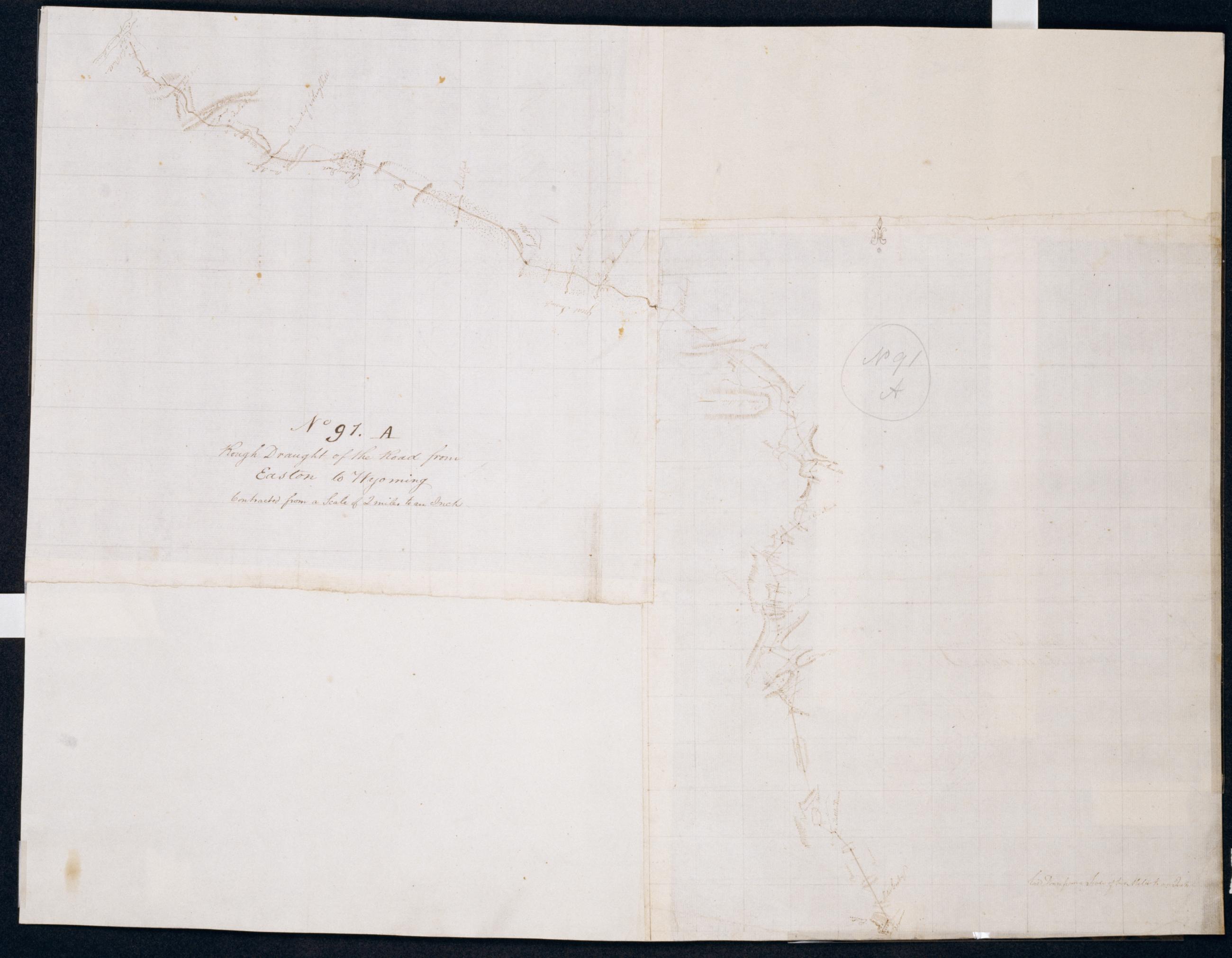
Cartographic Rough Draught of the Road from Easton to Wyoming : Contracted from a Scale of 2 miles to an inch. No 91. A / by Robert Erskine F.R.S. Geogr. A. U.S. and Assistants. Foxed, soiled, stained and abraded. Mounted on cloth, bound and cropped, disbound and silked by subsequent owners. Cleaned after removal of backings 1999; some fill remains. Lined with China paper. Sheathed in mylar. In pencil on recto: "No 91 A". Military topographic map. Covers parts of the counties of Luzerne, Monroe and Northampton in Pennsylvania. Shows roads between Easton and Wyoming. Also shows buildings and owners' names, landforms and streams. Pen-and-ink, pencil on 2 peieces laid paper. One additional piece of laid, another of wove finish paper added later at corners. View Item