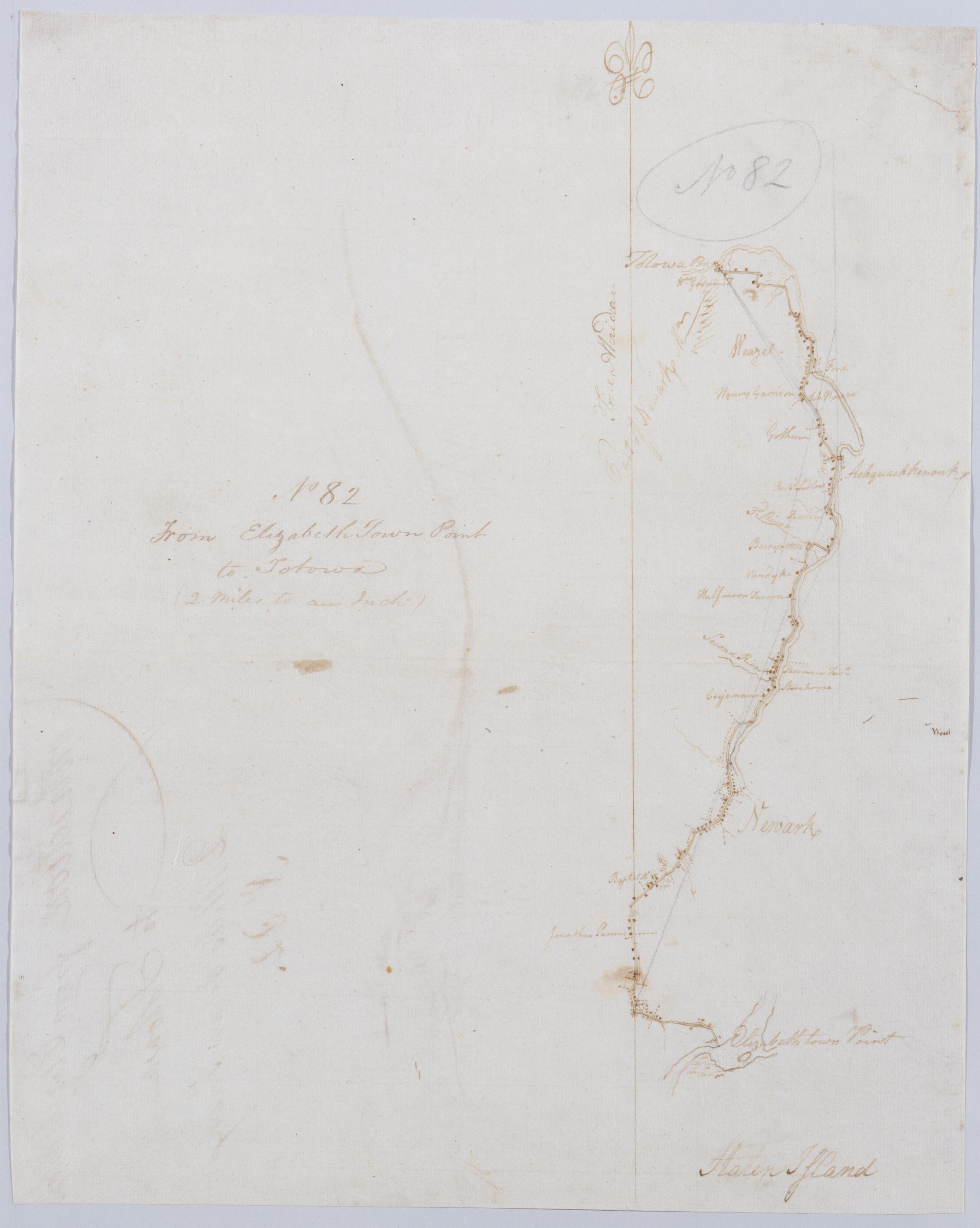
Cartographic From Elizabeth Town Point to Totowa : (2 Miles to an Inch) No 82 / by Robert Erskine F.R.S. Geogr. A. U.S. and Assistants. In pencil on recto: "No 82". Military topographic map. Covers parts of Passaic, Essex and Union counties in New Jersey. Shows roads running through Elizabeth, Newark, Belleville, Clifton, South Paterson and Totowa. Also shows buildings and owners' names, landforms and streams. Pen-and-ink, pencil on laid paper. Shows relief by hachures. Stained, soiled, frayed and abraded. Mounted on cloth, bound and cropped, disbound and silked by subsequent owners. Cleaned after removal of backings 1999; some fill remains. Sheathed in mylar. View Item
Cartographic Road from the Forks of the River Susquehanna towds Wyoming. No 95, A / by Robert Erskine F.R.S. Geogr. A. U.S. and Assistants. In pencil on recto: "No 95, A". Military topographic map. Covers part of Northumberland County, Pennsylvania. Shows roads running through Wolverton and Northumberland. Also shows buildings, landforms and streams. Pen-and-ink, pencil on laid paper. Shows relief by hachures. Stained, foxed, creased and abraded. Mounted on cloth, bound and cropped, disbound and silked by subsequent owners. Cleaned after removal of backings 1999; some fill remains. Sheathed in mylar. Title proper from recto is the work of a later editor--Simeon DeWitt or his assign--subsequent to 1820. View Item
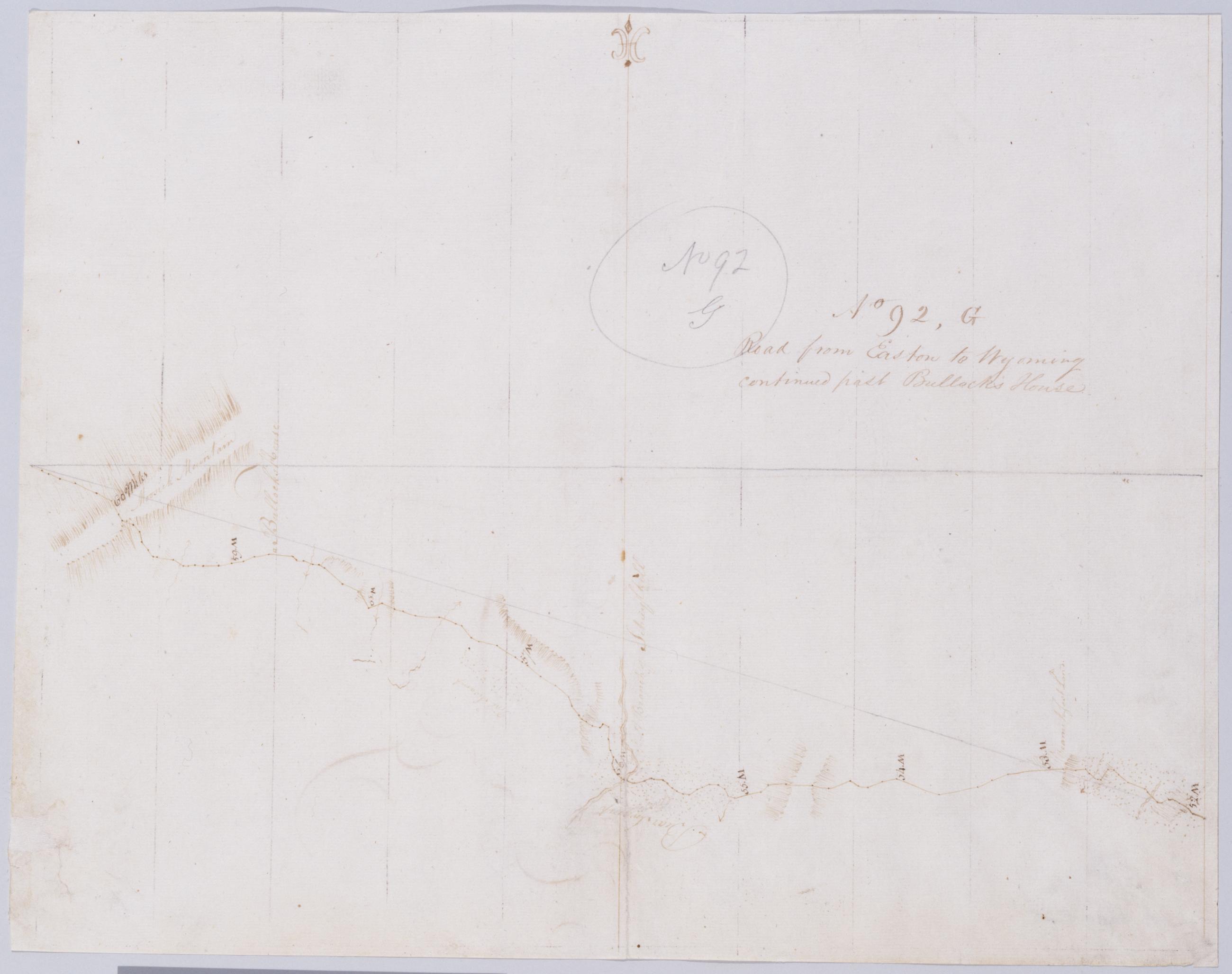
Cartographic Road from Easton to Wyoming continued past Bullock's House. No 92, G / by Robert Erskine F.R.S. Geogr. A. U.S. and Assistants. Creased, foxed, stained, soiled and abraded. Mounted on cloth, bound and cropped, disbound and silked by subsequent owners. Cleaned after removal of backings 1999; some fill remains. Sheathed in mylar. In pencil on recto: "No 92 G". Military topographic map. Covers the counties of Lackawanna and Luzerne, Pennsylvania. Shows roads. Also shows buildings and owners' names, landforms and streams. Pen-and-ink, pencil on laid paper. Scale from index title; confirmed by measuring the map itself. Shows relief by hachures. View Item
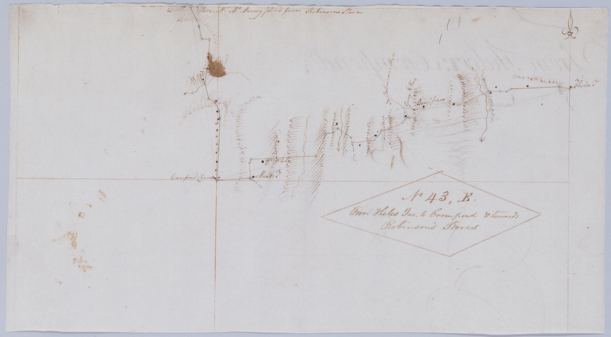
Cartographic From Theles Tav. to Crompond & towards Robinson's Stores. No 43, E / by Robert Erskine F.R.S. Geogr. A. U.S. and Assistants. Foxed, creased, frayed, and abraded. Mounted on cloth, bound and cropped, disbound and silked by subsequent owners. Cleaned after removal of backings 1999; some fill remains. Sheathed in mylar. Includes text: "Here Mr. McMurray joind from Robinsons Store". Military topographic map. Covers the townships of Somers and Yorktown in Westchester County, New York. Shows roads running through Somers Center, West Somers and Yorktown. Also shows buildings and owners' names, landforms and streams. Pen-and-ink, pencil on laid paper. Shows relief by hachures. View Item
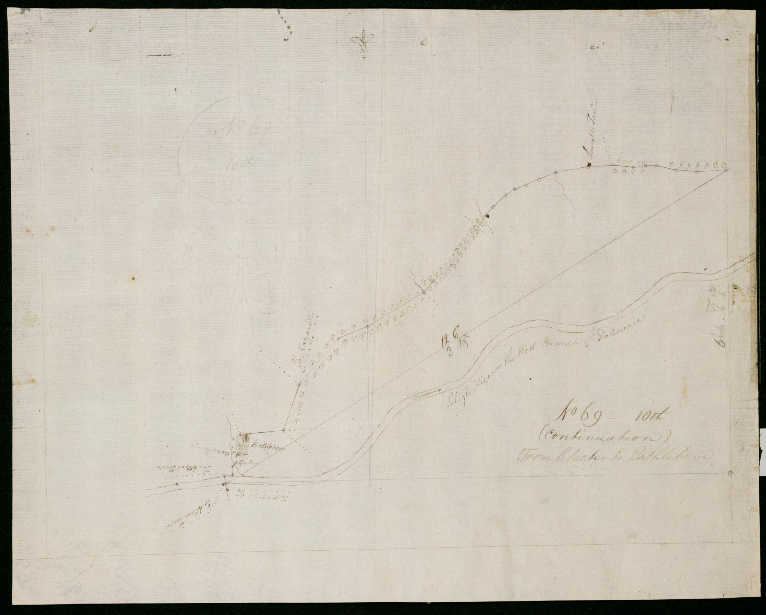
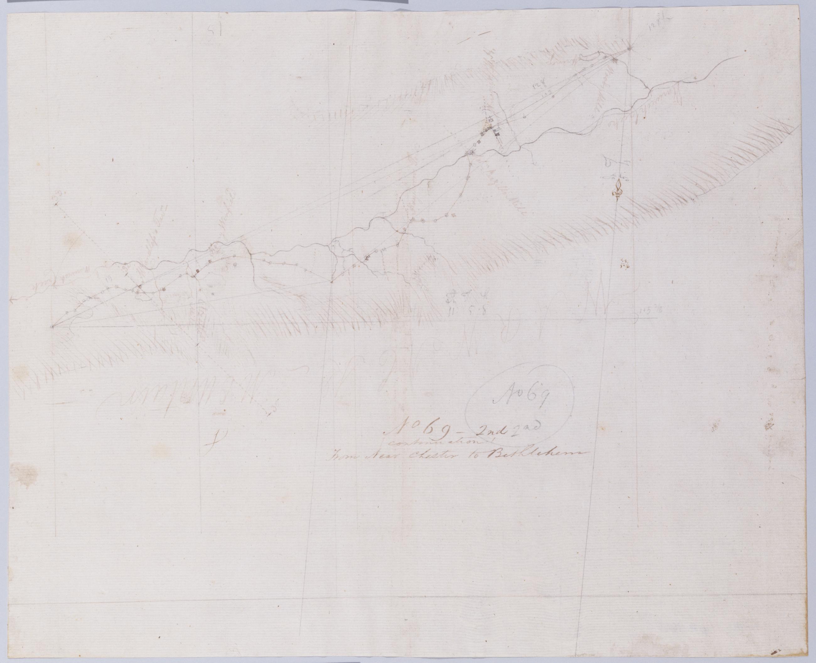
Cartographic (Continuation) From Chester to Bethlehem. No 69-10th / by Robert Erskine F.R.S. Geogr. A. U.S. and Assistants. In pencil on recto: "No 69 10th". Military topographic map. Covers Northampton County, Pennsylvania. Shows roads running through Bethlehem. Also shows buildings and owners' names, landforms and streams. Pen-and-ink, pencil on laid paper. Shows relief by hachures. Stained, creased and abraded. Mounted on cloth, bound and cropped, disbound and silked by subsequent owners. Cleaned after removal of backings 1999; some fill remains. Sheathed in mylar. Title proper on recto is the work of a later editor--Simeon DeWitt or his assign--subsequent to 1820. View Item
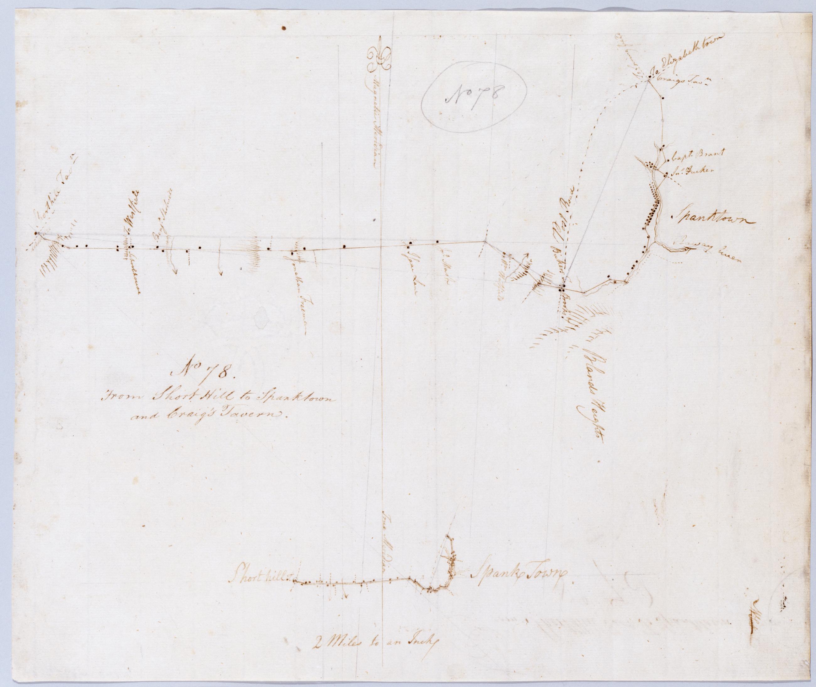
Cartographic From Short Hill to Spanktown and Craig's Tavern. No 78 / by Robert Erskine F.R.S. Geogr. A. U.S. and Assistants. In pencil on recto: "No 78". Includes inset map of same area at "2 Miles to an Inch" or 1:127,000. Military topographic map. Covers the townships of Rahway and Westfield in Union County and of Raritan and Woodbridge in Middlesex County, New Jersey. Shows roads running through Potters and Rahway (formerly Spanktown). Also shows buildings and owners' names, landforms and streams. Pen-and-ink, pencil on laid paper. Shows relief by hachures. Stained and abraded. Mounted on cloth, bound and cropped, disbound and silked by subsequent owners. View Item
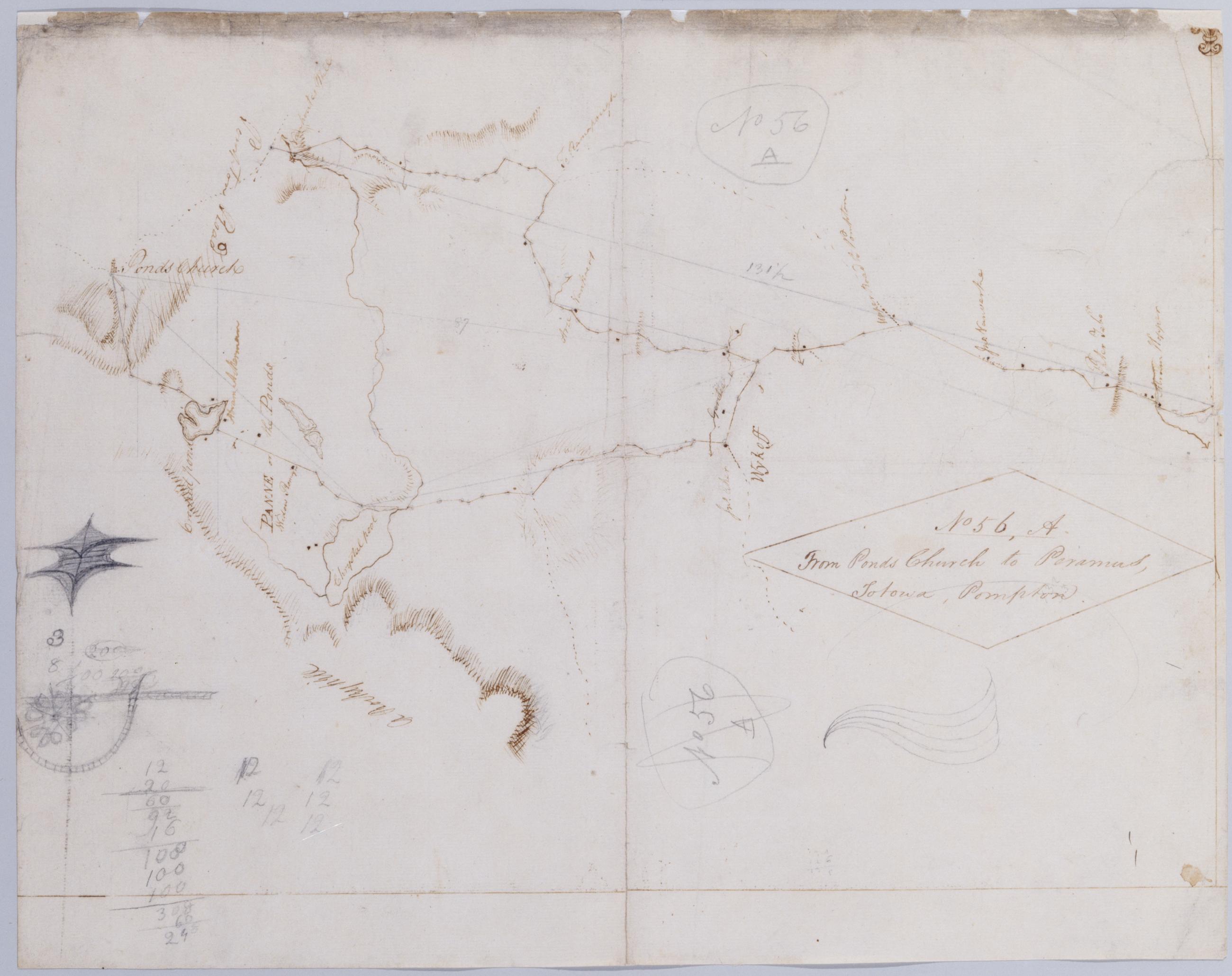
Cartographic From Ponds Church to Paramus, Totowa, Pompton. No 56, A / by Robert Erskine F.R.S. Geogr. A. U.S. and Assistants. In pencil on recto: "No 56 A". Military topographic map. Covers the township of Franklin in Bergen County, New Jersey; "Chrystal pool" is now called Franklin Lake. Shows roads running through Pompton Lakes, Pompton, Oakland, Camp Gaw, Wykoff and Waldwick. Also shows buildings and owners' names, landforms and streams. Pen-and-ink, pencil on laid paper. Shows relief by hachures. Title proper from recto is the work of a later editor--Simeon DeWitt or his assign--subsequent to 1820. Title from verso is in Erskine's hand and may be cited as such. View Item
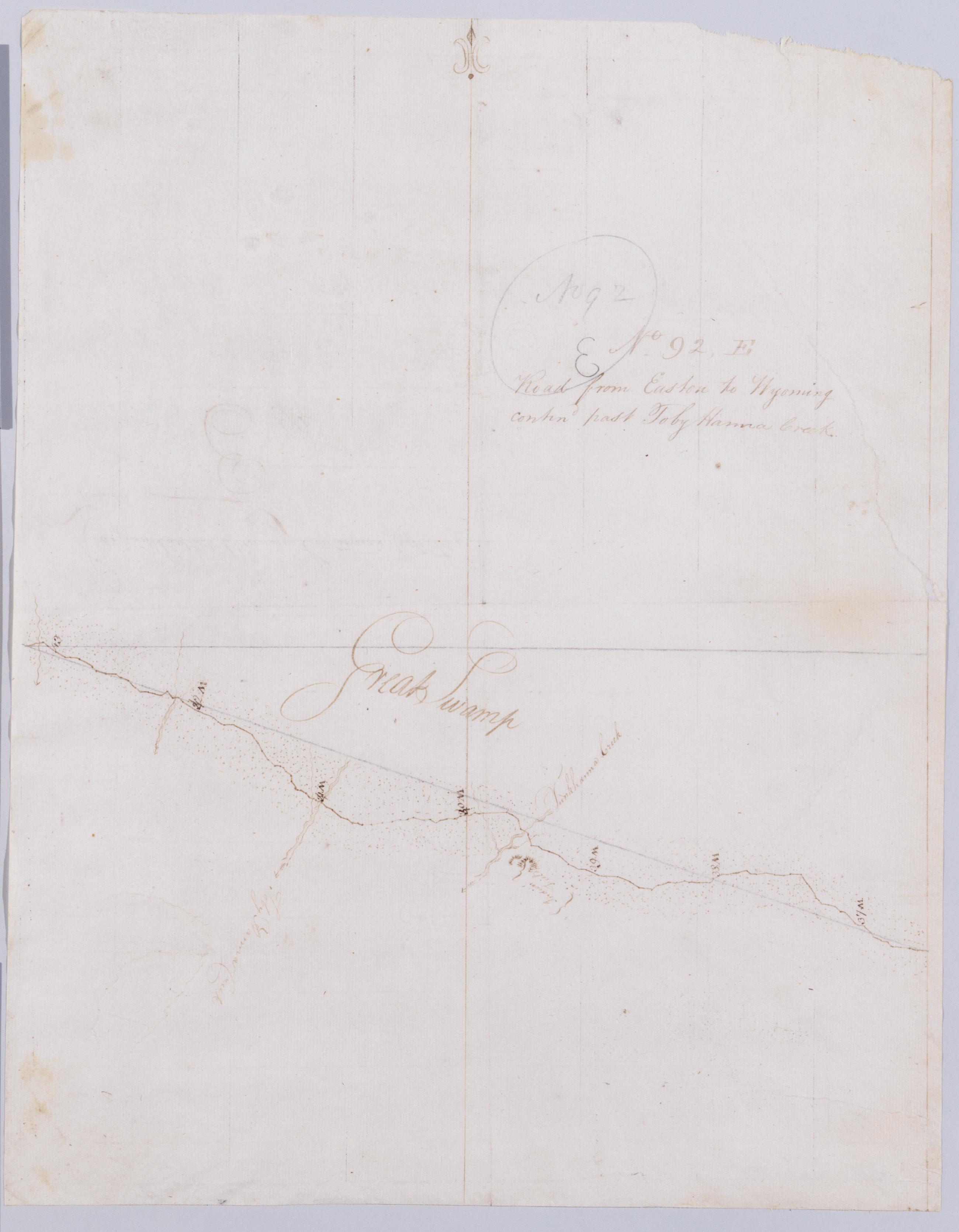
Cartographic Road from Easton to Wyoming contind past Toby Hanna Creek. No 92, E / by Robert Erskine F.R.S. Geogr. A. U.S. and Assistants. In pencil on recto: "No 92 E". Military topographic map. Covers Monroe County, Pennsylvania. Shows roads. Also shows buildings and owners' names, landforms and streams. Pen-and-ink, pencil on laid paper. Paper itself imperfect. Scale from index title; confirmed by measuring the map itself. Shows relief by hachures. Stained, soiled, torn and abraded. Mounted on cloth, bound and cropped, disbound and silked by subsequent owners. Cleaned after removal of backings 1999; some fill remains. Sheathed in mylar. View Item
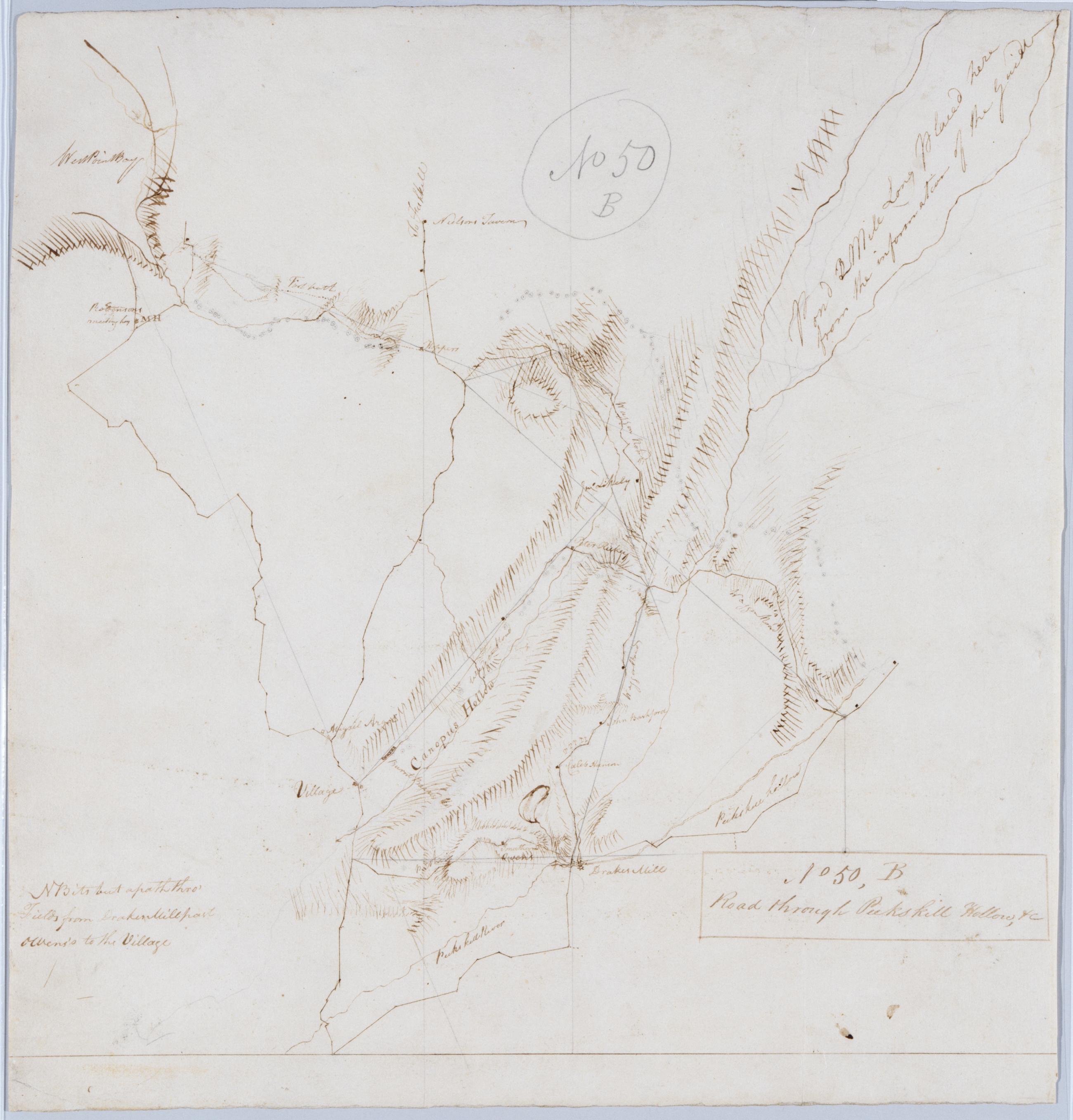
Cartographic Road through Peekskill Hollow, +c. No 50, B / by Robert Erskine F.R.S. Geogr. A. U.S. and Assistants. Foxed, frayed and abraded. Pinpricks for copying. Mounted on cloth, bound and cropped, disbound and silked by subsequent owners. Cleaned after removal of backings 1999; some fill remains. Sheathed in mylar. In ink on verso: "No. 50. B Done July 1779". In pencil on recto: "No 50 B". Includes text: "NB its but apath thro' Fields from Drake[s] Mill past owen's to the Village". Military topographic map. Covers the towns of Putnam Valley and Phillipstown in Putnam County, New York. View Item
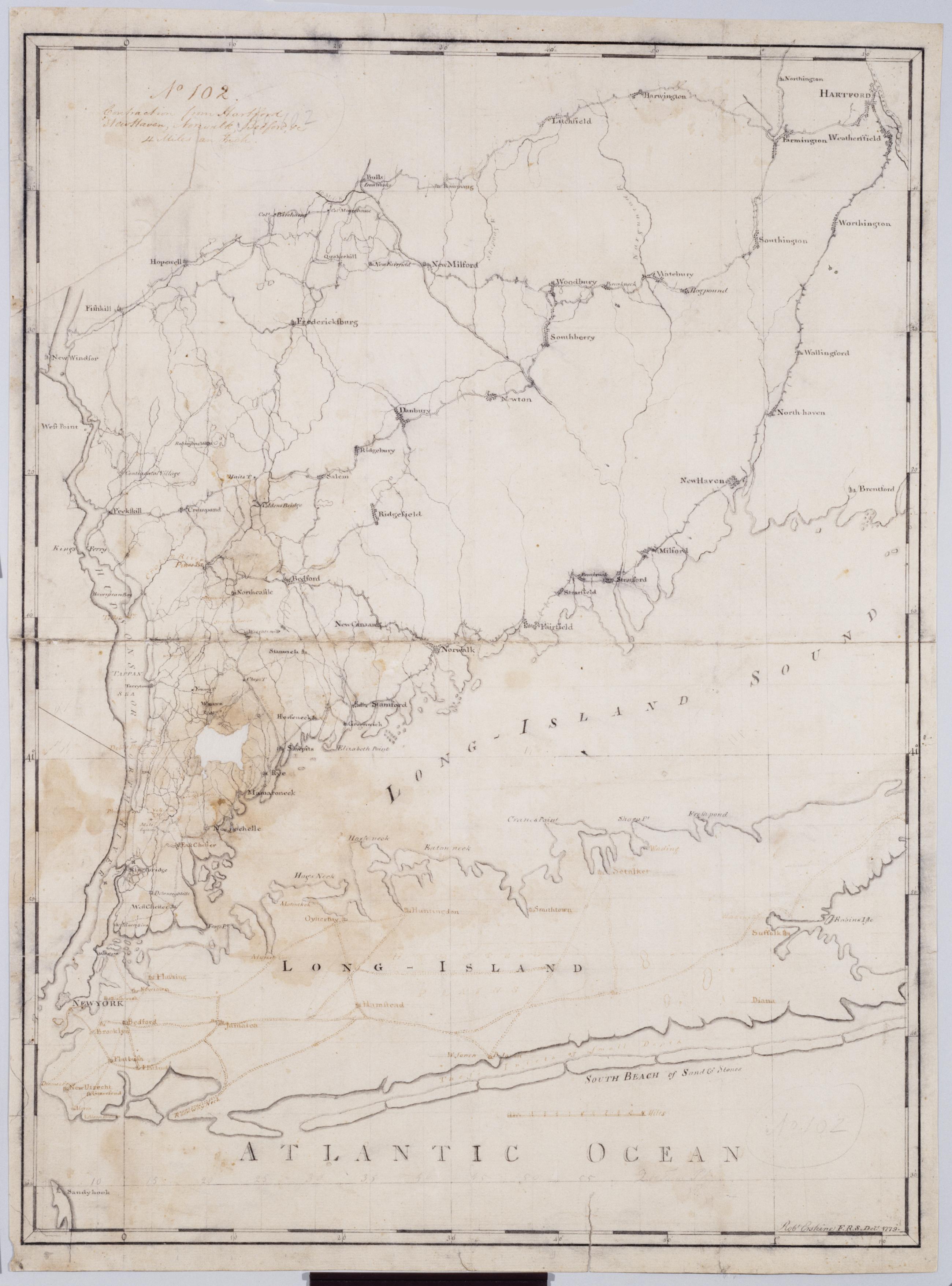
Cartographic Contraction from Hartford New Haven, Norwalk, Bedford +c. No 102 / Robt Erskine F.R.S. Delt. 1779 ; by RE ; by Robert Erskine F.R.S. Geogr. A. U.S. and Assistants. Imperfect: lacking 2 x 3 cm. at left center. In ink on verso: "No. 102". In pencil on recto: "No 102". Military topographic map. Covers Westchester, Putnam, Nassau and Suffolk counties in New York, and also New York City; and Fairfield, Litchfield, New Haven and Hartford Counties in Connecticut. Pen-and-ink, pencil on laid paper. Planar projection. Soiled, stained, mildewed creased, frayed and abraded. Mounted on cloth, bound, disbound and silked by subsequent owners. Cleaned after removal of backings 1999; relined with China paper. Sheathed in mylar. View Item
Cartographic From Susquehanna to Bushtown. No 124, E / by Robert Erskine F.R.S. Geogr. A. U.S. and Assistants. Date 1781 inferred by cataloger. Military topographic map. Covers the counties of Cecil and Harford in Maryland. Shows roads running through Perryville, Havre de Grace, Osborne, Swan Creek Farms, Aberdeen, Stepney and Bush. Also shows buildings and owners' names, landforms and streams. Pen-and-ink, pencil on laid paper. Shows relief by hachures. Stained, soiled, creased and abraded. Mounted on cloth, bound and cropped, disbound and silked by subsequent owners. Cleaned after removal of backings 1999; some fill remains. Sheathed in mylar. View Item
Cartographic From Hooes Ferry to Port Tobacco. No 125 F / by Robert Erskine F.R.S. Geogr. A. U.S. and Assistants Date inferred by cataloger. Foxed, soiled and abraded. Mounted on cloth, bound and cropped, disbound and silked by subsequent owners. Cleaned after removal of backings 1999; some fill remains. Sheathed in mylar. Military topographic map. Covers Charles County in Maryland. Shows roads running through Newburg, Lothair Station, Bel Alton and Port Tobacco. Also shows buildings, landforms and streams. Pen-and-ink, pencil on laid paper. Shows relief by hachures. Title proper from recto is the work of a later editor--Simeon DeWitt or his assign--subsequent to 1820. View Item
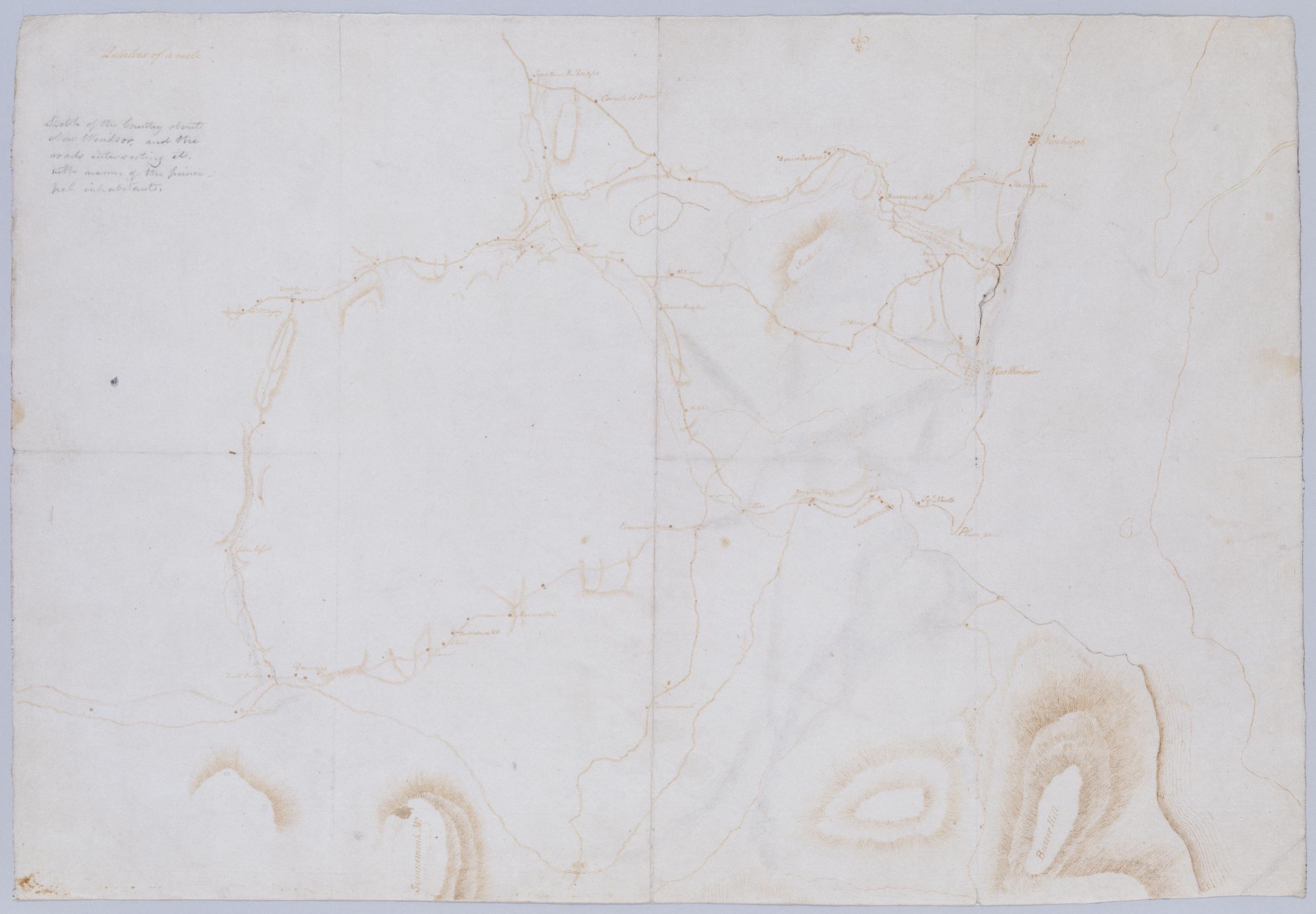
Cartographic Sktch of the Country about New Windsor, and the roads intersecting it, with names of the principal inhabitants. Foxed, soiled, creased and abraded. Mounted on cloth, bound and cropped, disbound and silked by subsequent owners. Cleaned after removal of backings 1999; some fill remains. Sheathed in mylar. In pencil on verso: "for F De Peyster Esq." DePeyster was a 19th century official of the New York Historical Society. Military topographic map. Covers the towns of New Windsor, Newburg, Cornwall and Blooming Grove in Orange County, New York. Shows roads, some buildings and owners' names, streams and landforms. Pen-and-ink, pencil on laid paper. Shows relief by hachures. View Item
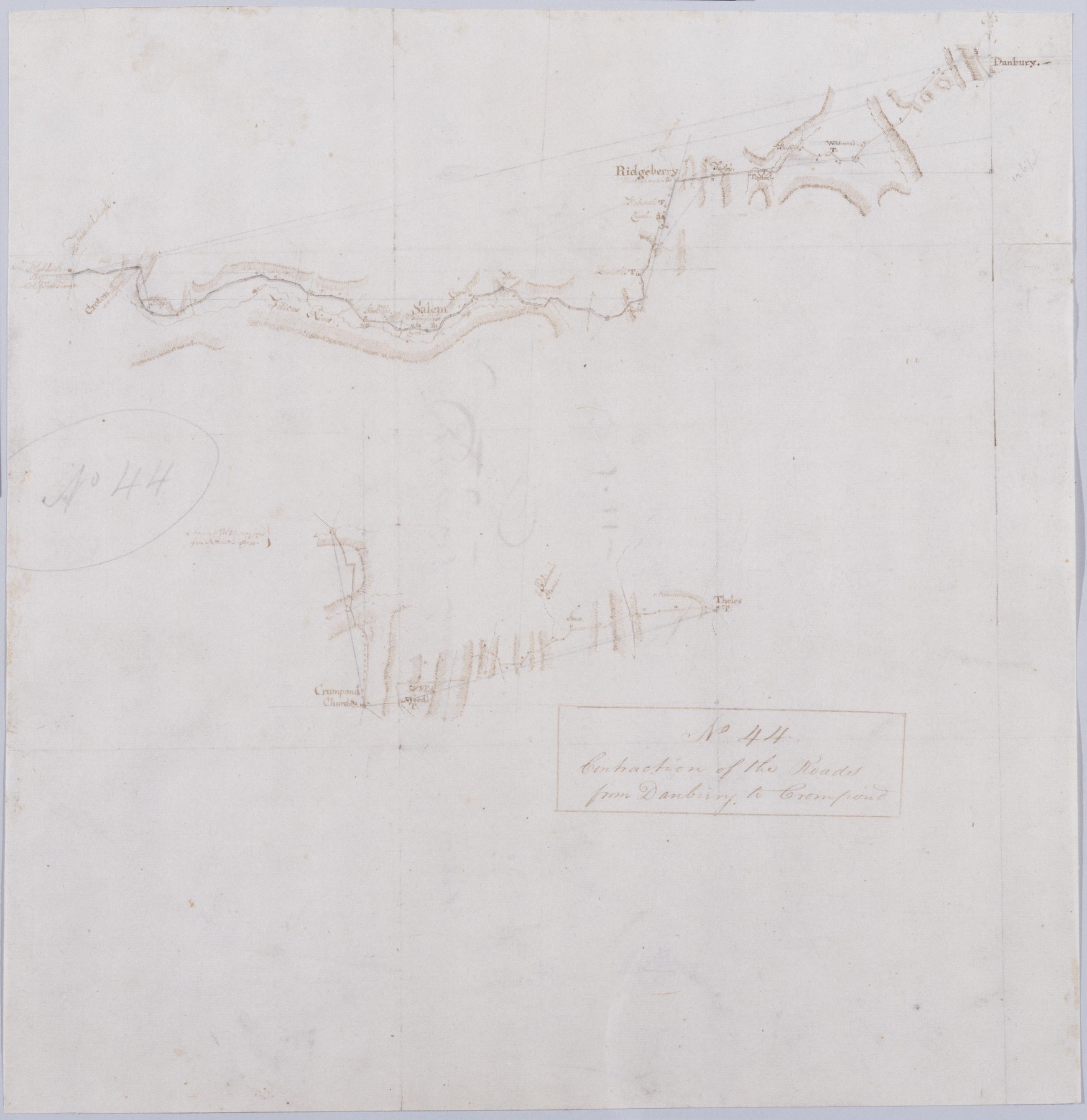
Cartographic Contraction of the Roads from Danbury to Crompond. No 44 / by Robert Erskine F.R.S. Geogr. A. U.S. and Assistants. Foxed, creased, frayed, and abraded. Razorcut along roads for copying. Mounted on cloth, bound and cropped, disbound and silked by subsequent owners. Cleaned after removal of backings 1999; some fill remains. Sheathed in mylar. In pencil on recto: "No 44". Military topographic map; lower segment lies to west of upper segment. Map covers the towns of Ridgefield and Bethel in Fairfield County, Connecticut, and of Yorktown, Somers and North Salem in Westchester County, New York. View Item
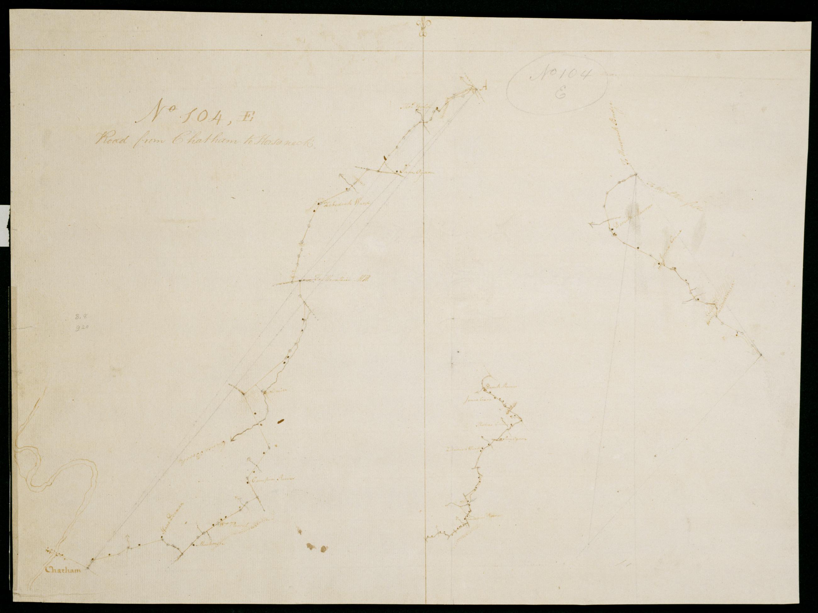
Cartographic Road from Chatham to Horseneck. No 104, E / by by Robert Erskine F.R.S. Geogr. A. U.S. and Assistants. In pencil on recto: "No 104 E". Military topographic maps. The left and right drawings, meeting at point "A," constitute the principal map. The drawing at center is a mere "contraction" of this. Both maps cover the townships of Milburn, Livingston, North Caldwell and Caldwell in Essex County, New Jersey, and show roads running through Chatham, Northfield, Livingston, Roseland, Essex Fells, Caldwell and Franklin. They also show buildings and owners' names, landforms and streams. Pen-and-ink, pencil on laid paper. Shows relief by hachures. Soiled, stained, frayed and abraded. View Item
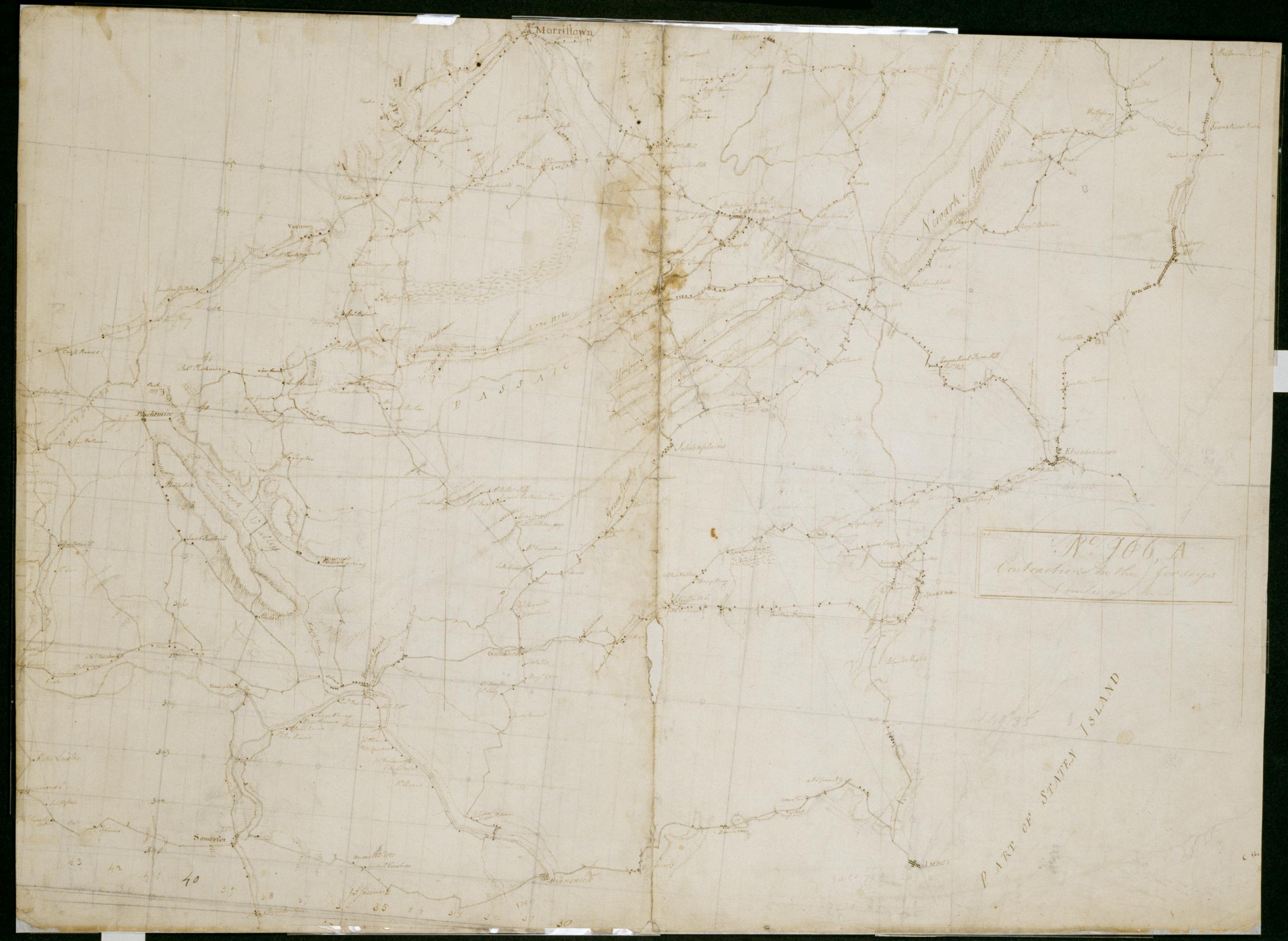
Cartographic Contraction in the Jerseys 1 mile an Inch. No. 106, A / by S. DeWitt A.B. ; by Robert Erskine F.R.S. Geogr. A. U.S. and Assistants. Imperfect: lacking 6 x 1 cm. at lower center of sheet. In ink on verso "No- 106- A". In pencil on recto: "No 106 A". Military topographic map. Covers the counties of Middlesex, Union, Essex, Somerset and Morris in New Jersey. Shows buildings and owners' names, landforms and streams. Pen-and-ink, pencil on laid paper. Shows relief by hachures. Stained, creased, frayed and abraded. Mounted on cloth, bound and cropped, disbound and silked by subsequent owners. Cleaned after removal of backings 1999; re-backed with China paper. Sheathed in mylar. View Item
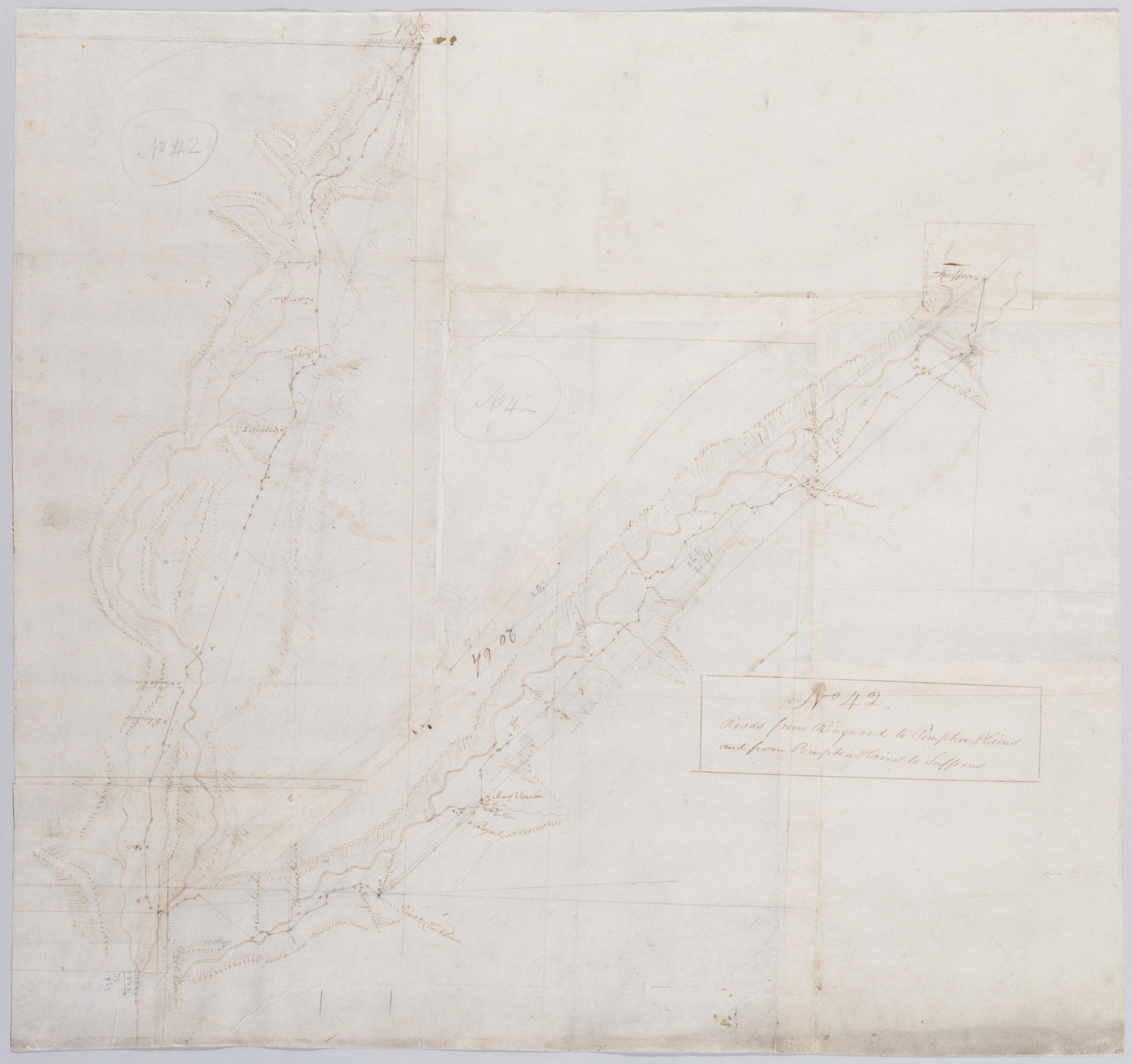
Cartographic Roads from Ringwood to Pompton Plains and from Pompton Plains to Sufferns. No 42 / by Robert Erskine F.R.S. Geogr. A. U.S. and Assistants. Also in ink on verso: "42". Foxed, creased, frayed, and abraded. Mounted on cloth, bound and cropped, disbound and silked by subsequent owners. Cleaned after removal of backings 1999; some fill remains. Sheathed in mylar. In pencil on recto: "No 42" (twice). Military topographic map. Covers the townships of Franklin and Hohokus in Bergen County, New Jersey; of Pompton in Passaic County, New Jersey; and of Ramapo in Rockland County, New York. Shows roads running though Ringwood, Erskine, Ringwood Junction, Midvale, Wanaque, Haskell, Pompton Lakes, Oakland, Darlington and Suffern. View Item
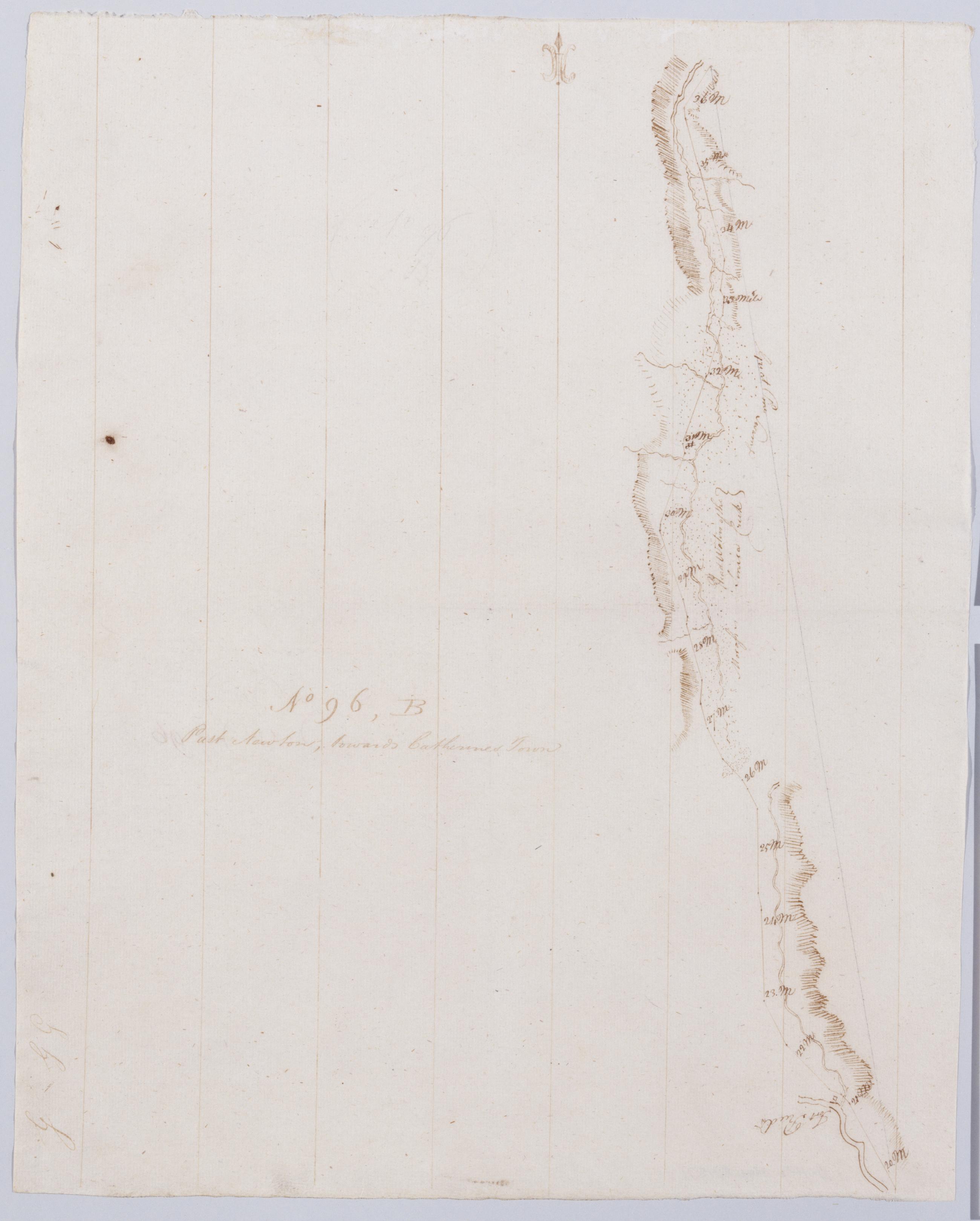
Cartographic Past Newton, towards Catherines Town. No 96, B / by Robert Erskine F.R.S. Geogr. A. U.S. and Assistants. In pencil on recto, "No 96 B". Military topographic map. Covers the towns of Catlin, Veteran, Horseheads and Elmira in Chemung County, New York. Shows roads running through Elmira, Horseheads, Pine Valley and Millport. Also shows landforms and streams. Pen-and-ink, pencil on laid paper. Scale statement from verso of sheet 96,A. Shows relief by hachures. Stained and abraded. Mounted on cloth, bound, disbound and silked by subsequent owners. Cleaned after removal of backings 1999; some fill remains. Sheathed in mylar. View Item
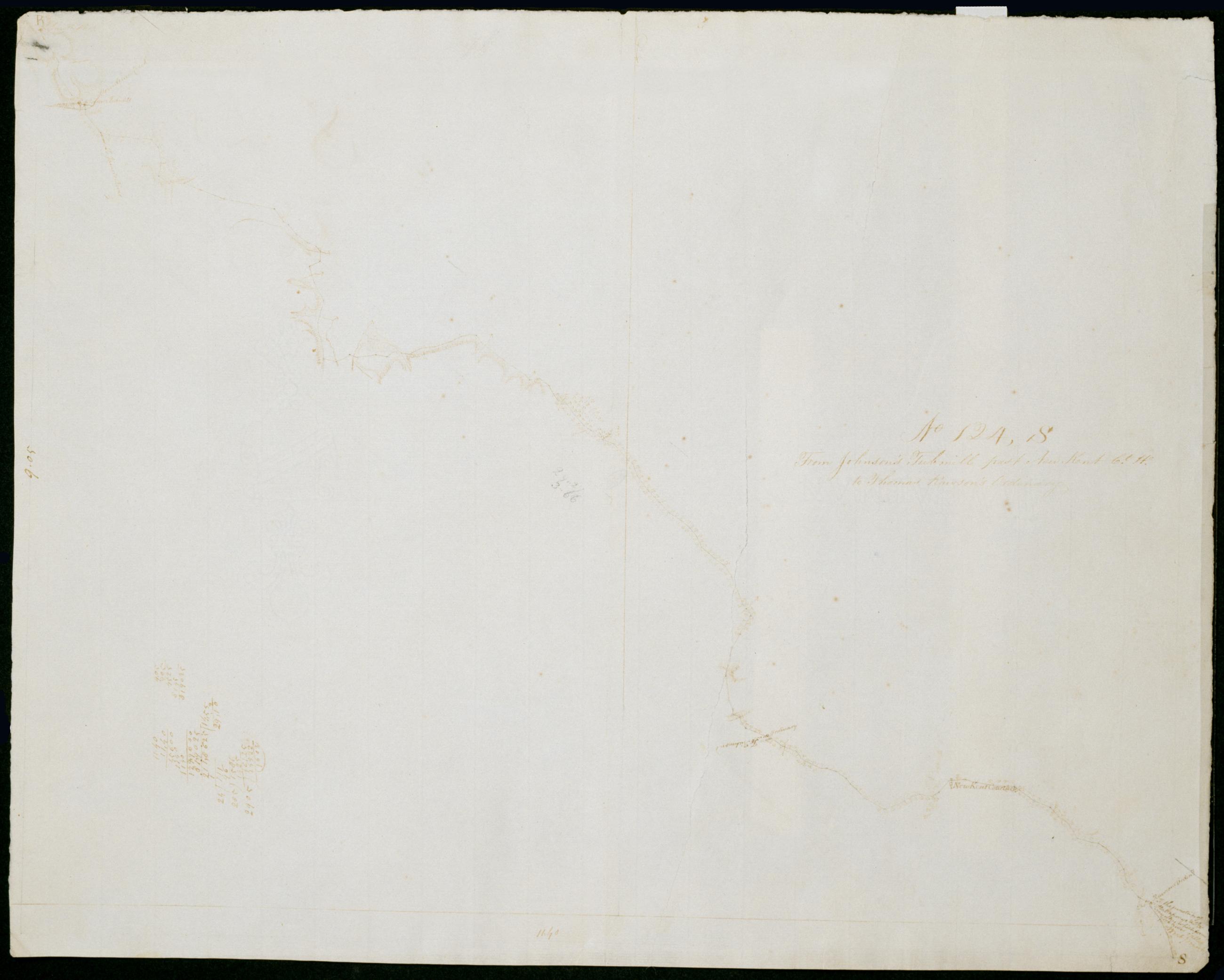
Cartographic From Johnson's Tubmill past New Kent Ct. He. to Thomas Rawson's Ordinary. No 124, S / by Robert Erskine F.R.S. Geogr. A. U.S. and Assistants. Date 1781 inferred by cataloger. Foxed, soiled, creased, torn and abraded. Mounted on cloth, bound and cropped, disbound and silked by subsequent owners. Cleaned after removal of backings 1999; some fill remains. Sheathed in mylar. Military topographic map. Covers the counties of Hanover and New Kent in Virginia. Shows roads running through Tunstall, Carps Corner, New Kent and Slaterville. Also shows buildings, landforms and streams. Pen-and-ink, pencil on laid paper. Shows relief by hachures. View Item
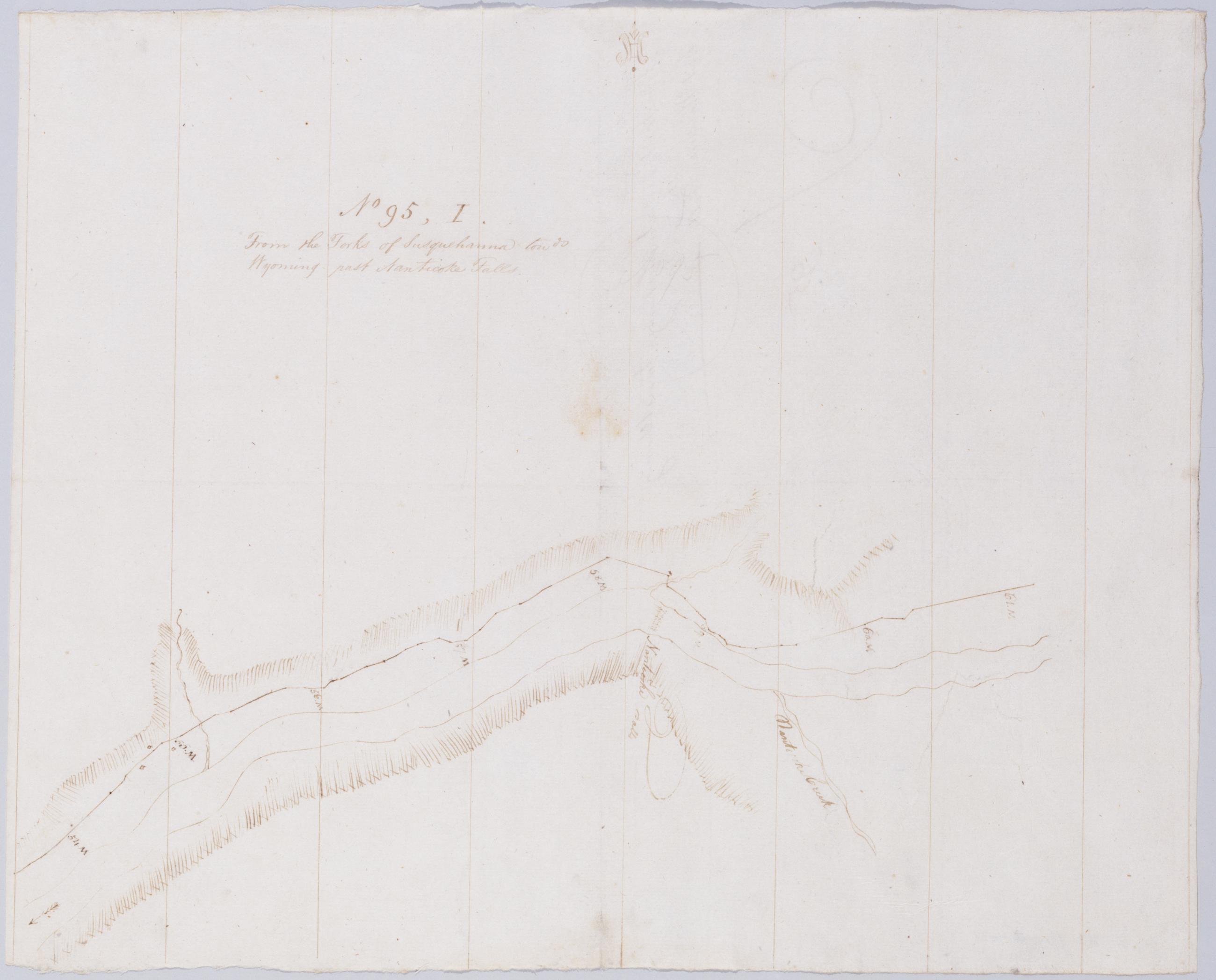
Cartographic From the Forks of Susquehanna towds Wyoming past Nanticoke Falls. No 95, I / by Robert Erskine F.R.S. Geogr. A. U.S. and Assistants. In pencil on recto, "No 95 I". Military topographic map. Covers part of Luzerne County in Pennsylvania. Shows roads running through Nanticoke. Also shows landforms and streams. Pen-and-ink, pencil on laid paper. Shows relief by hachures. Soiled, foxed, creased and abraded. Mounted on cloth, bound, disbound and silked by subsequent owners. Cleaned after removal of backings 1999; some fill remains. Sheathed in mylar. Title proper from recto is the work of a later editor--Simeon DeWitt or his assign--subsequent to 1820. Title from verso is in Erskine's hand and may be cited as such. View Item
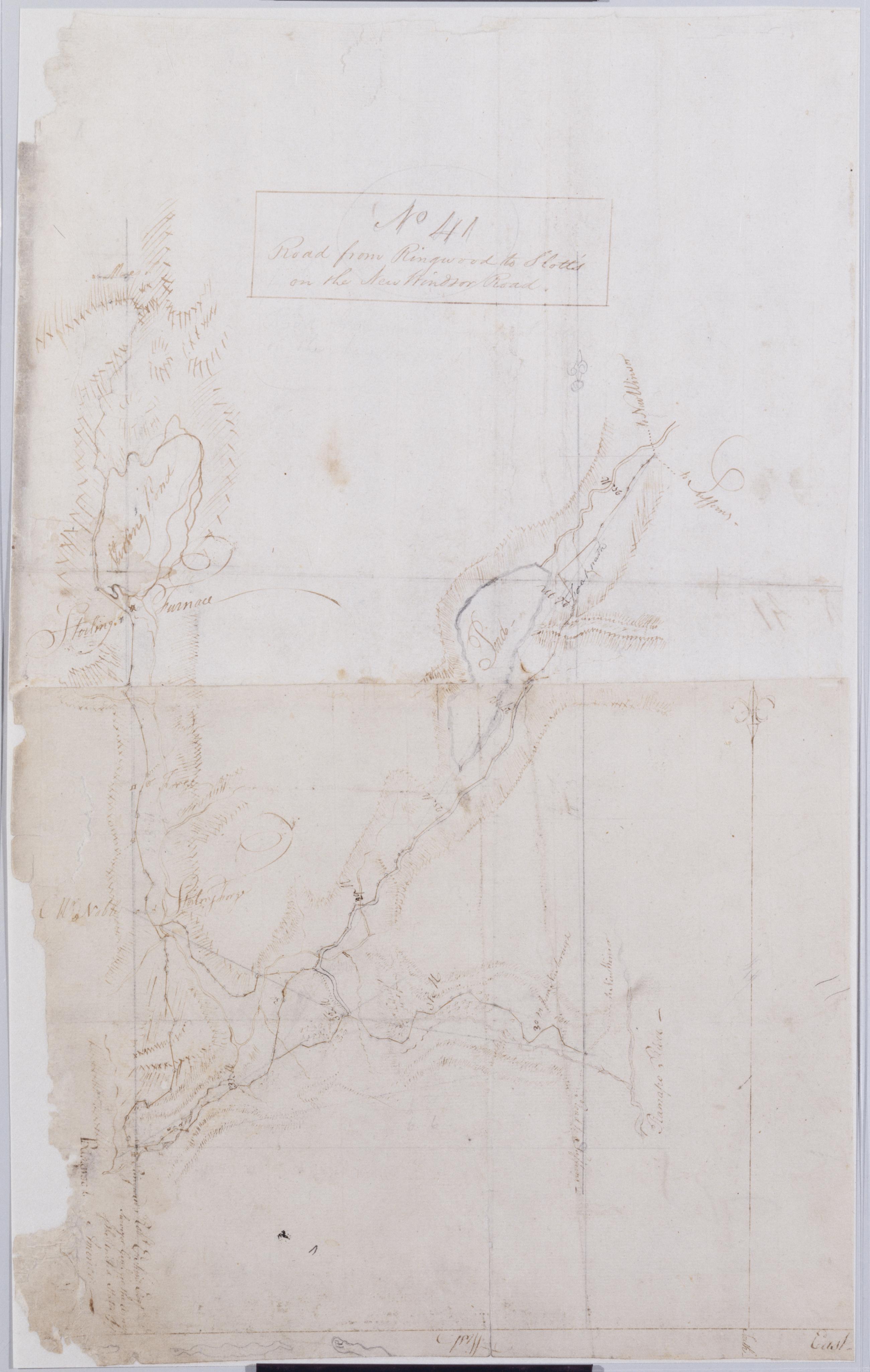
Cartographic Road from Ringwood to Slott's on the New Windsor Road. No 41 / by Robert Erskine F.R.S. Geogr. A. U.S. and Assistants. Foxed, creased, frayed, and abraded. Mounted on cloth, bound and cropped, disbound and silked by subsequent owners. Cleaned after removal of backings 1999; some fill remains. Sheathed in mylar. Map label at Ringwood: "Robt. Erskine Esqr. Surveyor Genl. for the Army of the United States of America--". Military topographic map. Covers the townships of Werwick and Tuxedo in Orange County, New York, Ramapo in Rockland County, New York, and Pompton in Passaic County, New Jersey. Shows roads running though Lakeville, Sterling Furnace, Ringwood, Eagle Valley, Sloatsburg and the Tuxedo Lake area. View Item
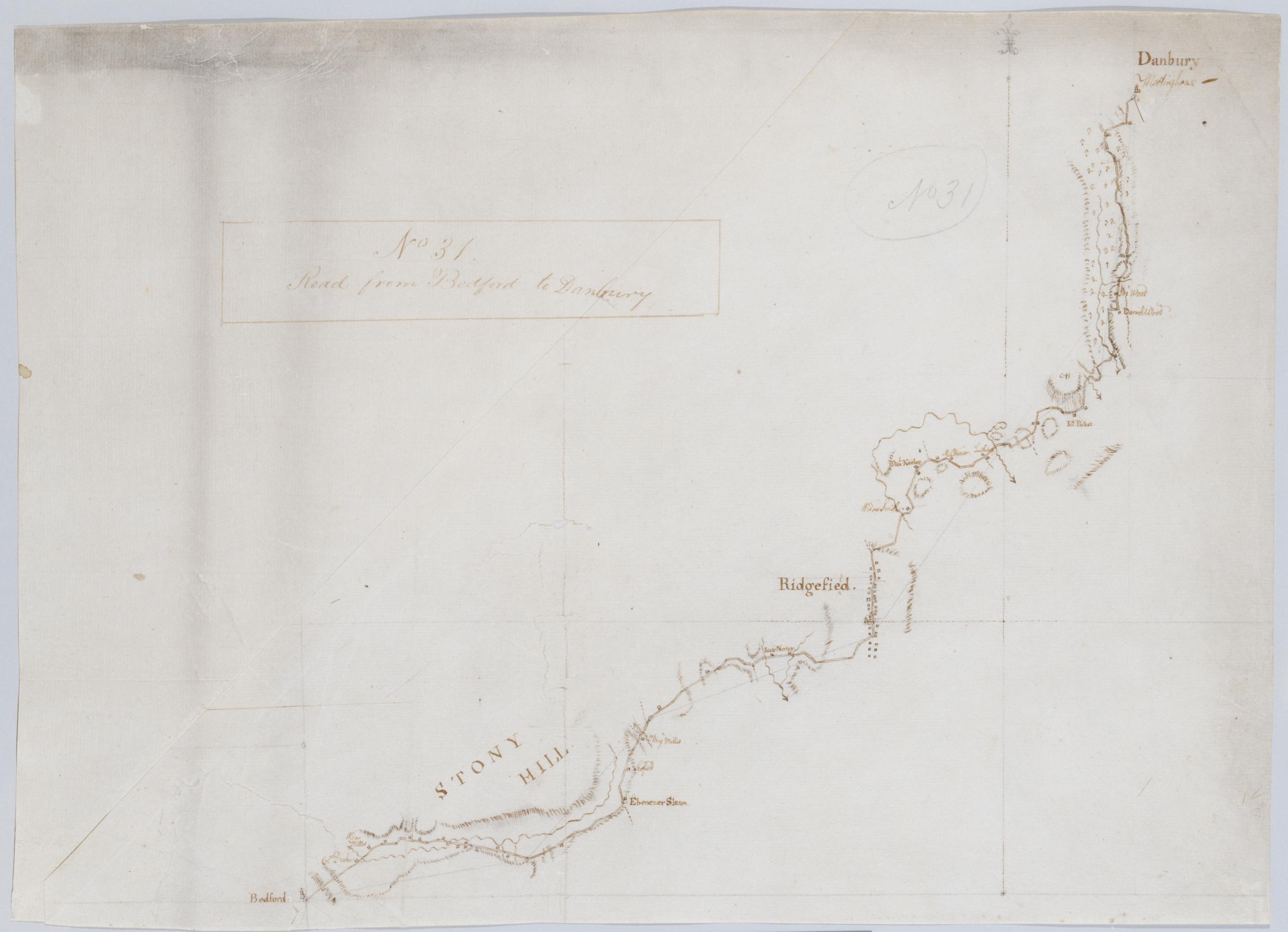
Cartographic Road from Bedford to Danbury. No 31 / by Robert Erskine F.R.S. Geogr. A. U.S. and Assistants. Foxed, creased, frayed, and abraded. Mounted on cloth, bound and cropped, disbound and silked by subsequent owners. Cleaned after removal of backings 1999; some fill remains. Sheathed in mylar. In pencil on recto: "No 31". Military topographic map. Covers the towns of Bedford, Poundridge and Lewisboro in Westchester County, New York and the towns of Bethel and Ridgefield in Fairfield County, Connecticut. Map shows roads running through Danbury, Ridgefield and Bedford. Also shows buildings and owners' names, landforms and streams. Pen-and-ink, pencil on laid paper. View Item
Cartographic Cross-road above Dobbs Ferry from Post Road to Saw-mill Rd. No 16 / by Robert Erskine F.R.S. Geogr. A. U.S. and Assistants. Foxed, creased, soiled and abraded. Mounted on cloth, bound and cropped, disbound and silked by subsequent owners. Cleaned after removal of backings 1999; some fill remains. Sheathed in mylar. In pencil on recto: "No 16." In ink on verso: "N. 16". Includes text: "Ends at Road below the 28 mile stone in No. 9". Military topographic map. Covers the town of Greenburg, Westchester County, New York. Shows roads running through Dublin (modern Irvington) as well as Dobbs Ferry. Also shows buildings and owners' names, landforms and streams. Pen-and-ink, pencil on laid paper. Shows relief by hachures. View Item
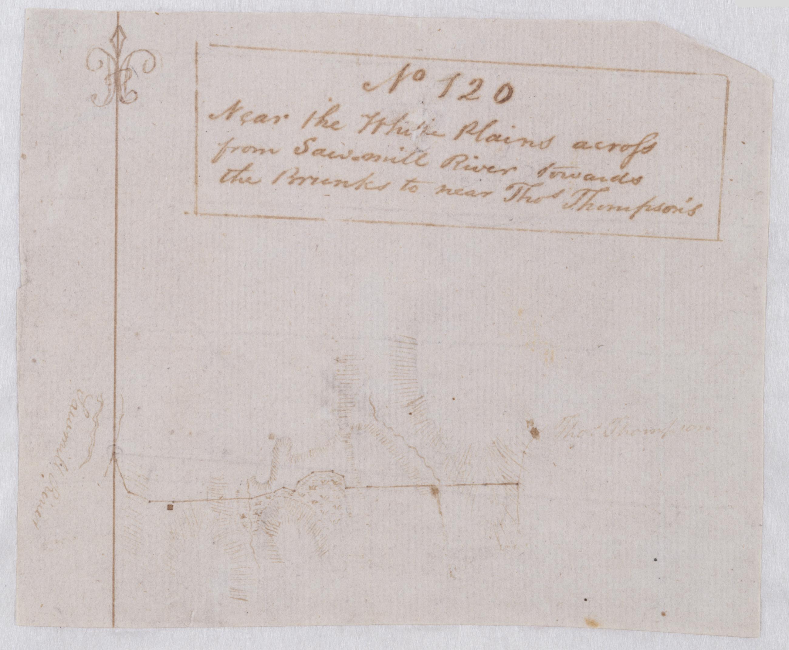
Cartographic Near the White Plains across from Sawmill River towards the Brunks to near Thos. Thompson's. No 120 / by Robert Erskine F.R.S. Geogr. A. U.S. and Assistants. Foxed and severely abraded. Cropped. For a time pasted above the lower margin of map No. 59 in series. Cleaned after removal of backings 1999; some fill remains. Sheathed in mylar. Military topographic map covering an area in Westchester County, New York. Probably the road shown as a dotted line on the map titled "A Draught of the Ground between the White Plains and Kingsbridge." This map shows buildings, landforms and streams. Pen-and-ink, pencil on laid paper. Shows relief by hachures. Title proper from recto is the work of a later editor--Simeon DeWitt or his assign--subsequent to 1820. View Item
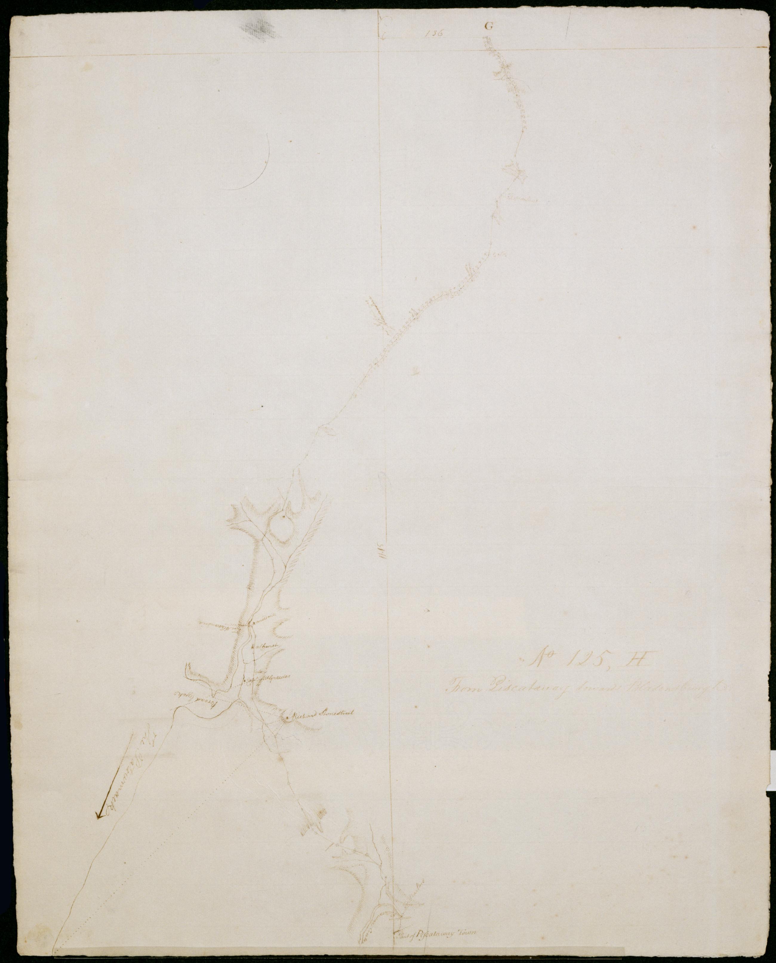
Cartographic From Piscataway towards Bladensburgh. No 125, H / by Robert Erskine F.R.S. Geogr. A. U.S. and Assistants. Date inferred by cataloger. Foxed, soiled and abraded. Mounted on cloth, bound and cropped, disbound and silked by subsequent owners. Cleaned after removal of backings 1999; some fill remains. Sheathed in mylar. Military topographic map. Covers Prince Georges County in Maryland. Shows roads running through Piscataway, Fort Washington Forest, Friendly Farms, Silesia, Oxon Hill, Silver Hill and Fort Chaplin Park in Washington D.C. Also shows buildings, landforms and streams. Pen-and-ink, pencil on laid paper. Shows relief by hachures. View Item
Cartographic (Continuation) From Near Chester to Bethlehem. No 69-2nd / by Robert Erskine F.R.S. Geogr. A. U.S. and Assistants. In pencil on recto: "No 69 2nd". Military topographic map. Covers the township of Warwick in Orange County, New York. Shows roads running through Warwick and New Milford. Also shows buildings and owners' names, landforms and streams. Pen-and-ink, pencil on laid paper. Shows relief by hachures. Stained, foxed, creased and abraded. Mounted on cloth, bound and cropped, disbound and silked by subsequent owners. Cleaned after removal of backings 1999; some fill remains. Sheathed in mylar. Title proper on recto is the work of a later editor--Simeon DeWitt or his assign--subsequent to 1820. View Item
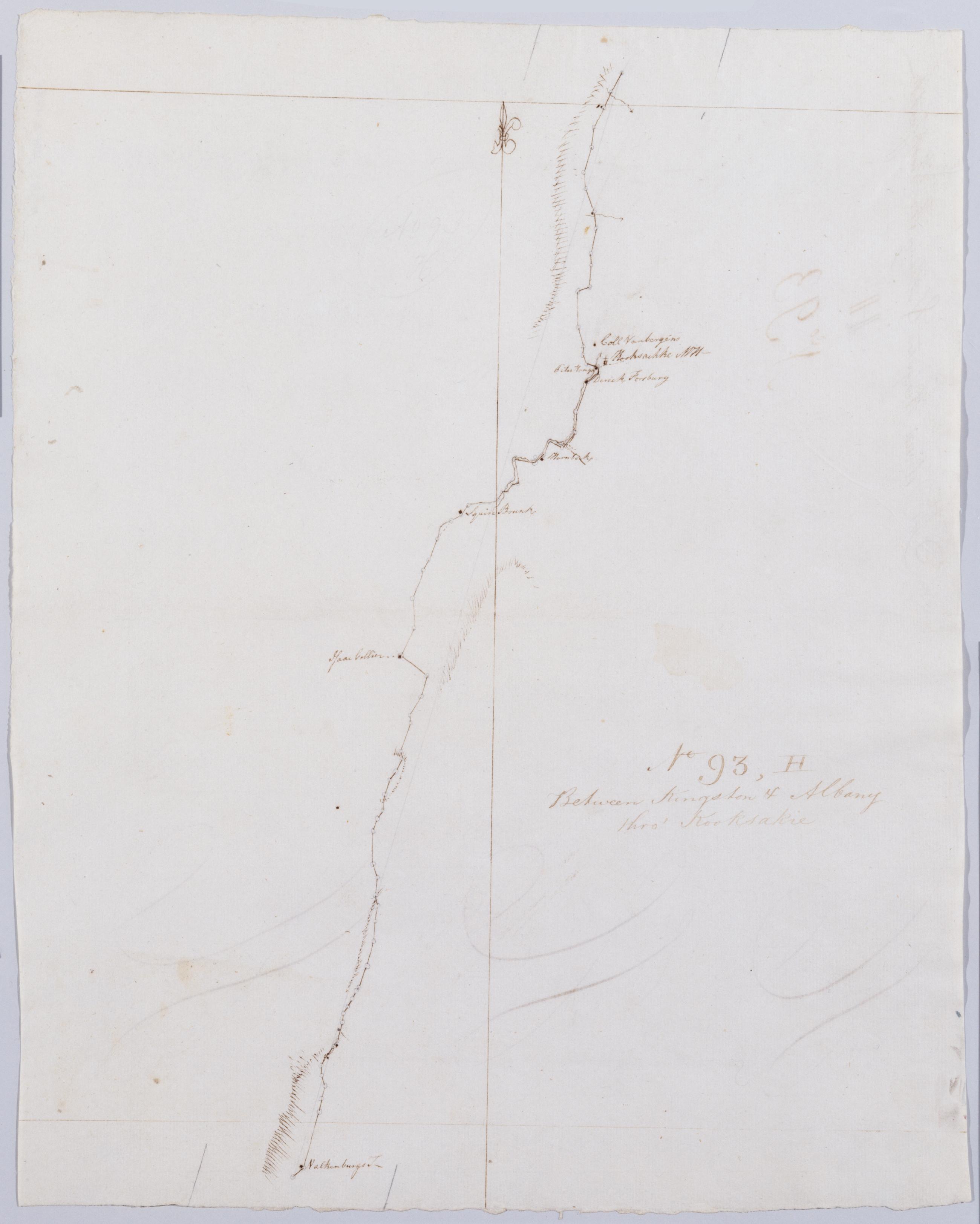
Cartographic Between Kingston + Albany thro' Kooksakie. No 93, H / by Robert Erskine F.R.S. Geogr. A. U.S. and Assistants. Foxed, stained, creased and abraded. Mounted on cloth, bound and cropped, disbound and silked by subsequent owners. Cleaned after removal of backings 1999; some fill remains. Sheathed in mylar. In erased pencil on recto: "No 93 H". In ink on verso: "H H H". Military topographic map. Covers the townships of Athens, Coxsackie and New Baltimore in Greene County, New York. Shows roads running through West Athens and West Coxsackie. Also shows buildings and owners' names, landforms and streams. Pen-and-ink, pencil on laid paper. Shows relief by hachures. View Item
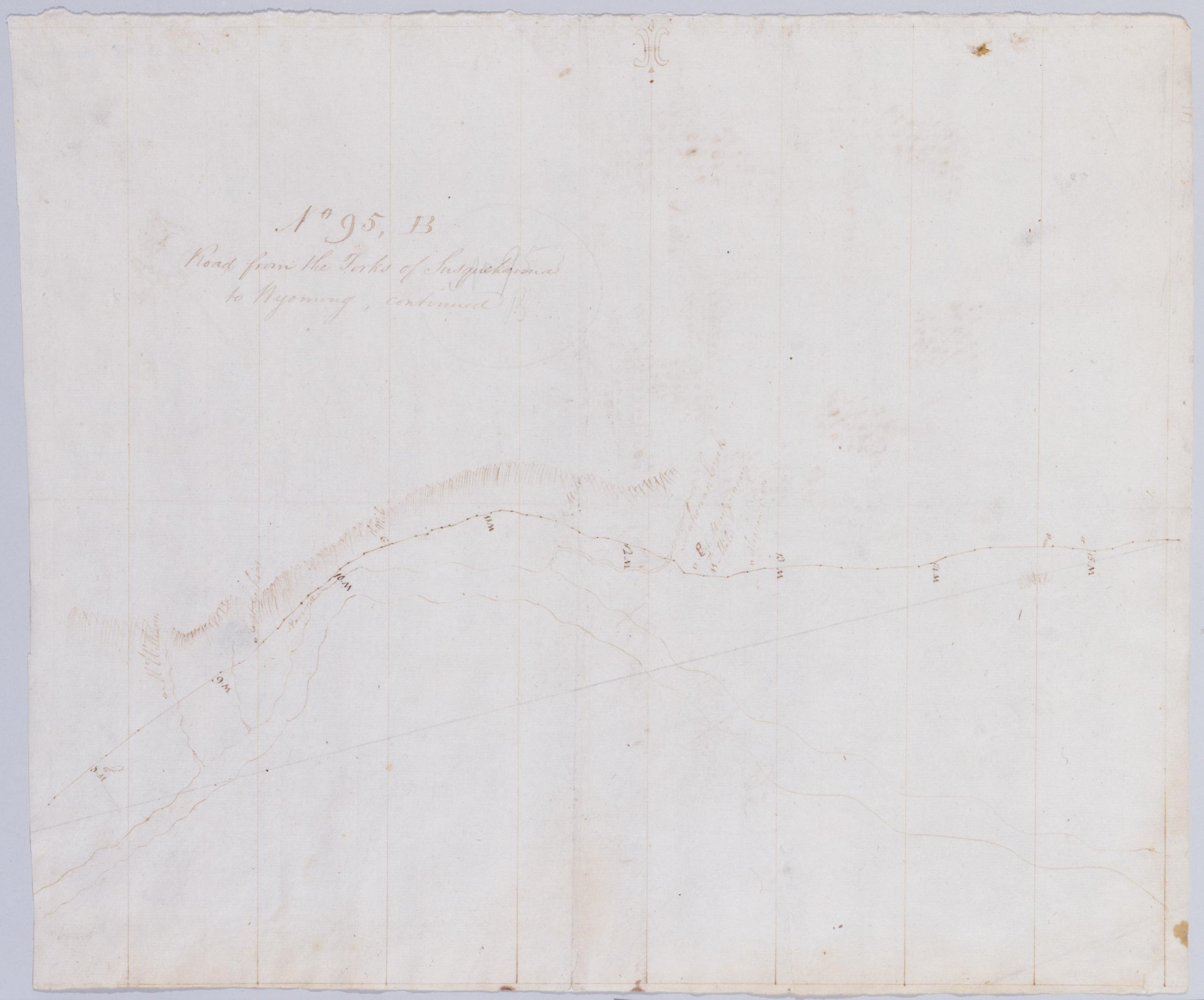
Cartographic Road from the Forks of Susquehanna to Wyoming, continued. No 95, B / by Robert Erskine F.R.S. Geogr. A. U.S. and Assistants. Also in ink on verso: arithmetical calculations. In pencil on recto: "No 95 B". Military topographic map. Covers parts of Northumberland and Montour counties, Pennsylvania. Shows roads running through Danville and Riverside. Also shows landforms and streams. Pen-and-ink, pencil on laid paper. Shows relief by hachures. Stained, foxed, creased and abraded. Mounted on cloth, bound, disbound and silked by subsequent owners. Cleaned after removal of backings 1999; some fill remains. Sheathed in mylar. View Item
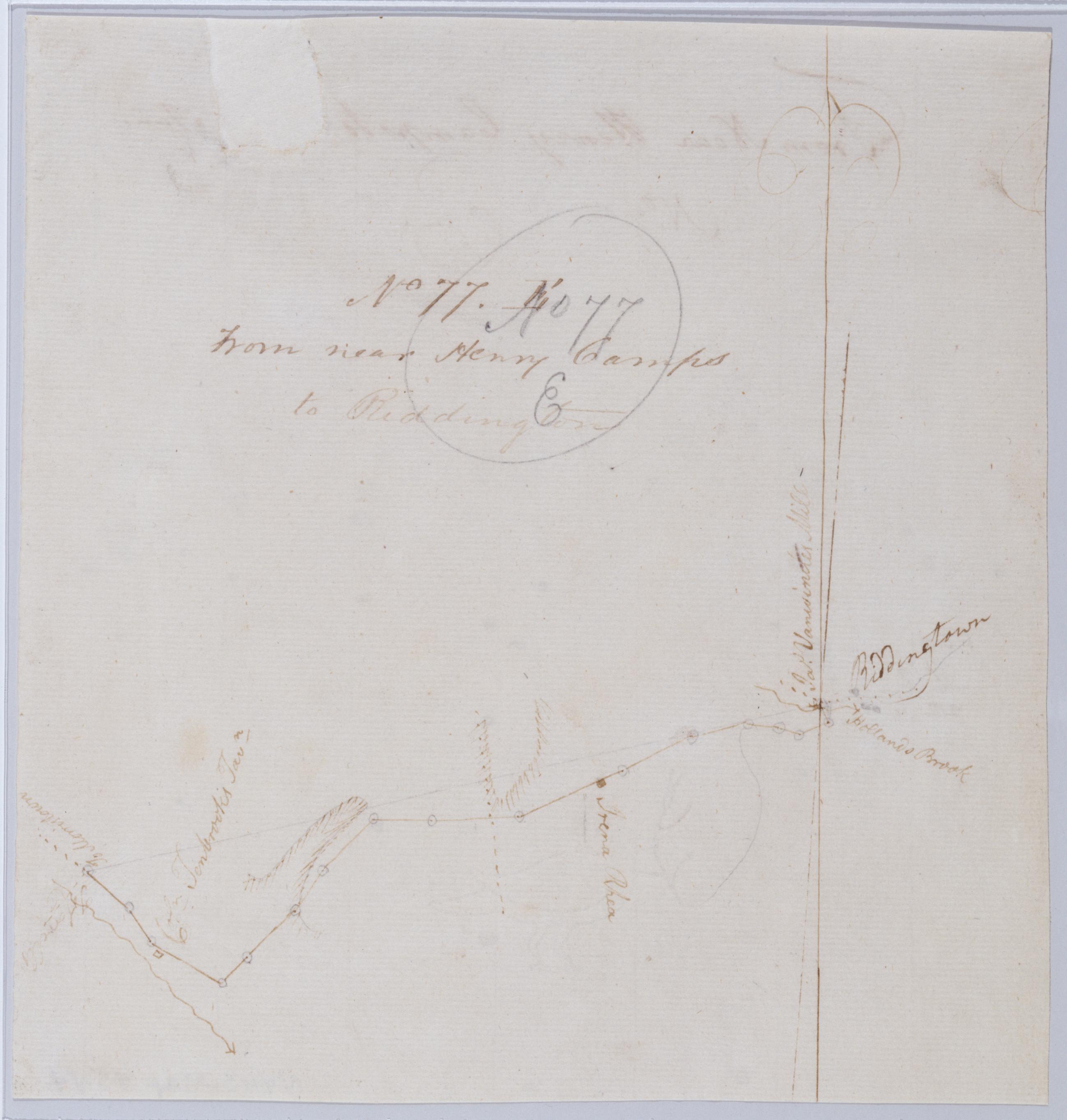
Cartographic From near Henry Camps to Reddington. No 77. E / by Robert Erskine F.R.S. Geogr. A. U.S. and Assistants. Frayed and abraded. Mounted on cloth, cropped and bound, disbound and silked by subsequent owners. Cleaned after removal of backings 1999; some fill remains. Sheathed in mylar. In pencil on recto: "No 77 E". Military topographic map. Covers Readington Township in Hunterdon County, New Jersey. Shows roads running through Pleasant Run and Readington. Also shows buildings and owners' names, landforms and streams. Pen-and-ink, pencil on laid paper. Shows relief by hachures. Title proper from recto is the work of a later editor--Simeon DeWitt or his assign--subsequent to 1820. View Item
Cartographic Roads from the Cross-roads through Pluckemin, towards Morristown. No 70, B / by Robert Erskine F.R.S. Geogr. A. U.S. and Assistants. Foxed, creased, torn, frayed and abraded. Mounted on cloth, bound and cropped, disbound and silked by subsequent owners. Cleaned after removal of backings 1999; some fill remains. Lined with China paper. Sheathed in mylar. Imperfect: lacking two small pieces at map center. In pencil on recto: "No 70 B". Military topographic map. Covers the townships of Bernard and Bedminster in Somerset County, New Jersey. Shows roads running through Greater Crossroads, Pluckemin and Liberty Corner. Also shows buildings and owners' names, landforms and streams. Pen-and-ink, pencil on laid paper. View Item