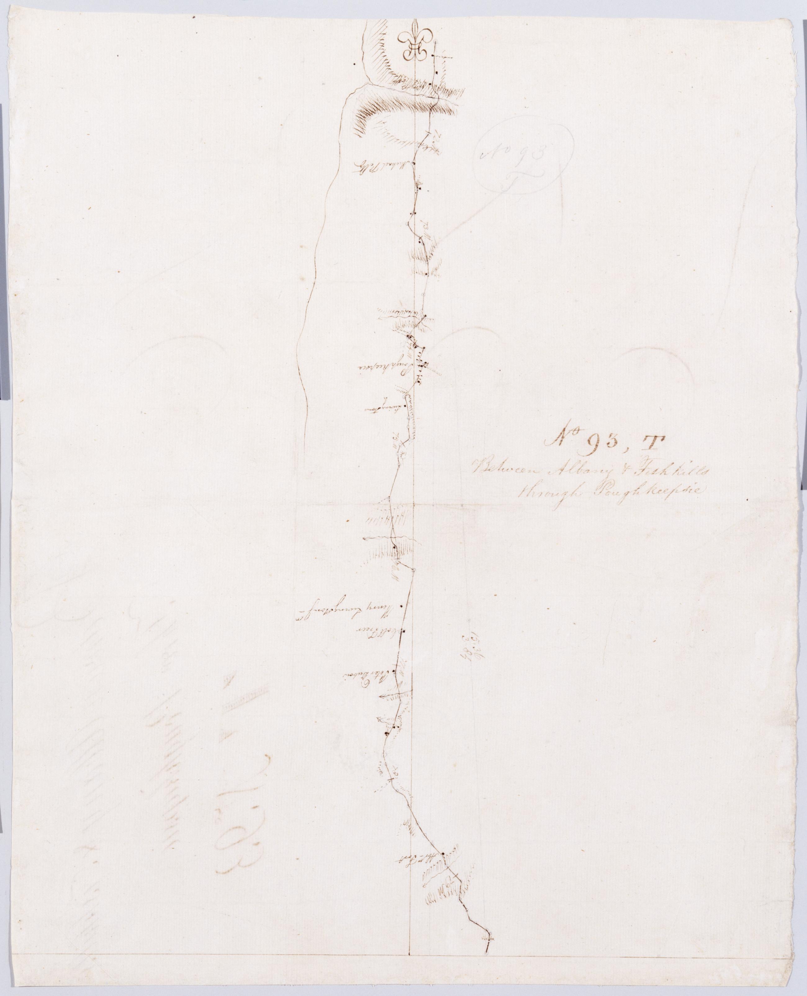
Cartographic Between Albany + Fishkills through Poughkeepsie. No 93, T / by Robert Erskine F.R.S. Geogr. A. U.S. and Assistants. Foxed, soiled, creased and abraded. Mounted on cloth, cropped and bound, disbound and silked by subsequent owners. Cleaned after removal of backings 1999; some fill remains. Sheathed in mylar. In ink on verso: "T T T". In pencil on recto: "No 93 T". Military topographic map. Covers the township of Hyde Park and Poughkeepsie in Dutchess County, New York. Shows roads running through Poughkeepsie. Also shows buildings and owners' names, landforms and streams. Pen-and-ink, pencil on laid paper. Shows relief by hachures. View Item
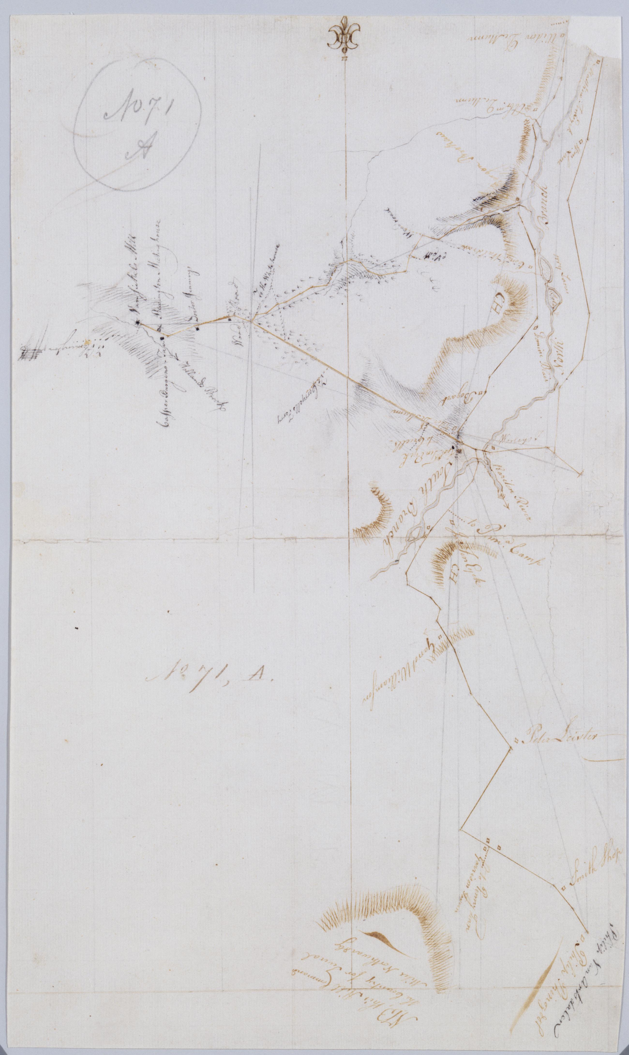
Cartographic [Garisons Somerset Boundbrook from South Branch to Reddington Brokaws] No. 71, A / by Robert Erskine F.R.S. Geogr. A. U.S. and Assistants. Foxed, creased, frayed and abraded. Mounted on cloth, bound and cropped, disbound and silked by subsequent owners. Cleaned after removal of backings 1999; some fill remains. Sheathed in mylar. In ink on verso: "A - 71". In pencil on recto "No 71 A". Military topographic map. Covers the townships of Readington and Branchburg in Hunterdon County and of Bridgewater and Hillsboro in Somerset County, New Jersey. Shows roads running through Readington, North Branch, Milltown, South Branch, Flagtown and Frankfort. Also shows buildings and owners' names, landforms and streams. View Item
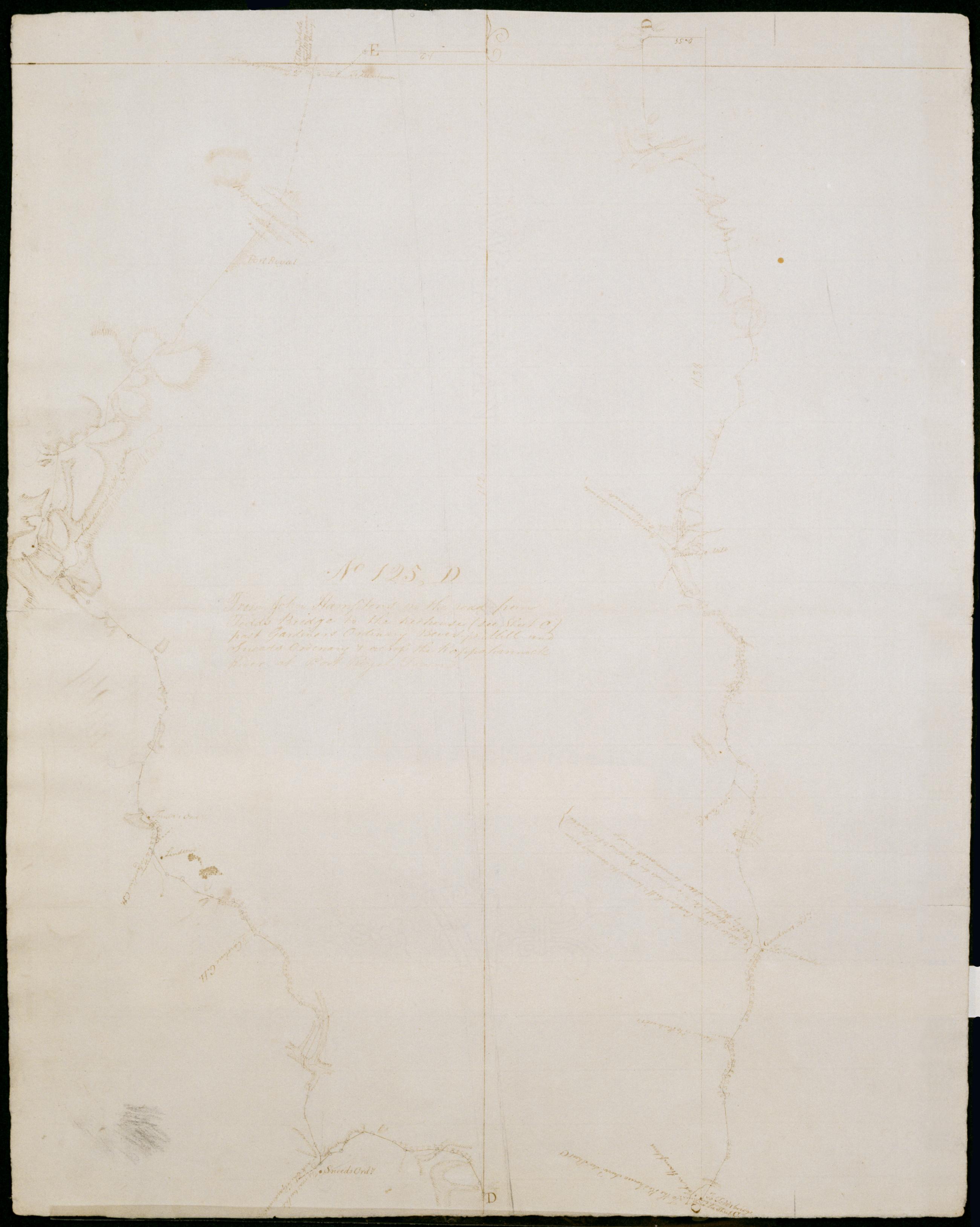
Cartographic From John Hampton's on the road from Todd's Bridge to the Redhouse (see Sheet C) past Gardiners Ordinary Beverly's Mill and Sneeds Ordinary + across the Rappahannock River at Port Royal Town. No 125, D / by Robert Erskine F.R.S. Geogr. A. U.S. and Assista Date inferred by cataloger. Military topographic map. Covers King and Queen County, Caroline County and King George County in Virginia. Shows roads running through Newton, Salvia, Central Point, Passing, Daniel Corner, Martins Corner, Goldmans Corner, Rollins Fork, Port Royal and Port Conway. Also shows buildings, landforms and streams. Pen-and-ink, pencil on laid paper. Shows relief by hachures. Soiled, creased and abraded. Mounted on cloth, bound and cropped, disbound and silked by subsequent owners. Cleaned after removal of backings 1999; some fill remains. Sheathed in mylar. View Item
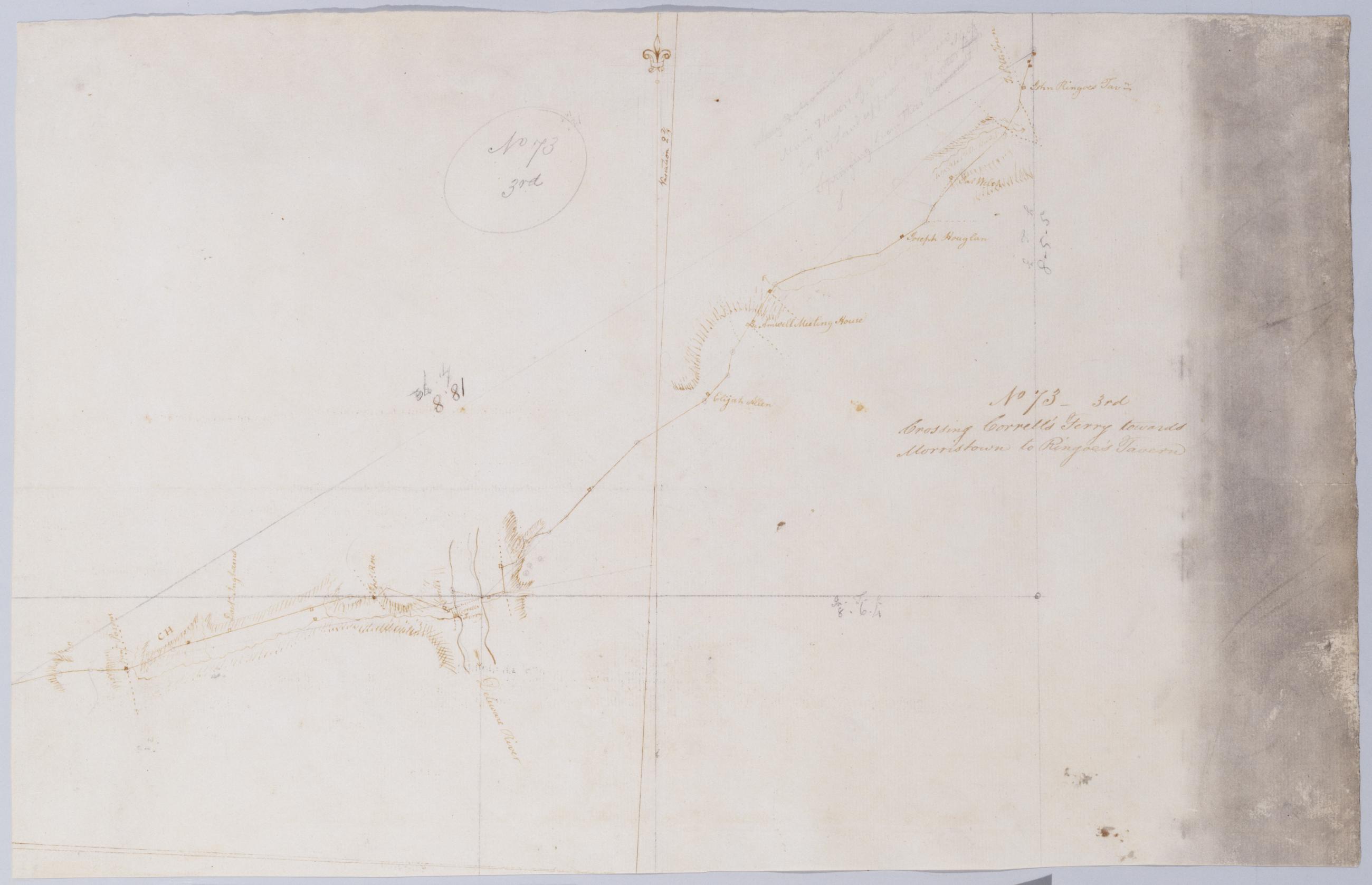
Cartographic Crossing Correll's Ferry towards Morristown to Ringoe's Tavern. No 73 - 3rd / by Robert Erskine F.R.S. Geogr. A. U.S. and Assistants. Heavily soiled, creased and abraded. Mounted on cloth, bound and cropped, disbound and silked by subsequent owners. Cleaned after removal of backings 1999; some fill remains. Sheathed in mylar. In pencil on recto: "No 73 3rd". Military topographic map. Covers the townships of Solebury in Bucks County, Pennsylvania, and of Delaware and West Amwell in Hunterdon County, New Jersey. Shows roads running through Deer Park and New Hope in Pennsylvania; Lambertville, Mount Airy and Ringoes in New Jersey. Also shows buildings and owners' names, landforms and streams. Pen-and-ink, pencil on laid paper. View Item
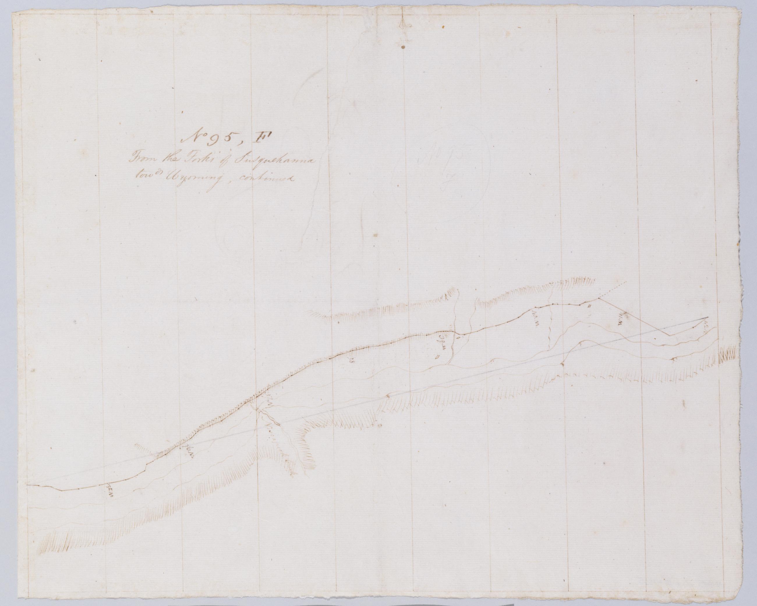
Cartographic From the Forks of Susquehanna towds Wyoming, continued. No 95, F / by Robert Erskine F.R.S. Geogr. A. U.S. and Assistants. In pencil on recto, "No 95 F". Military topographic map. Covers parts of Columbia and Luzerne counties in Pennsylvania. Shows roads running through Nescopeck and Berwick. Also shows landforms and streams. Pen-and-ink, pencil on laid paper. Shows relief by hachures. Soiled, foxed, creased and abraded. Mounted on cloth, bound, disbound and silked by subsequent owners. Cleaned after removal of backings 1999; some fill remains. Sheathed in mylar. Title proper from recto is the work of a later editor--Simeon DeWitt or his assign--subsequent to 1820. View Item
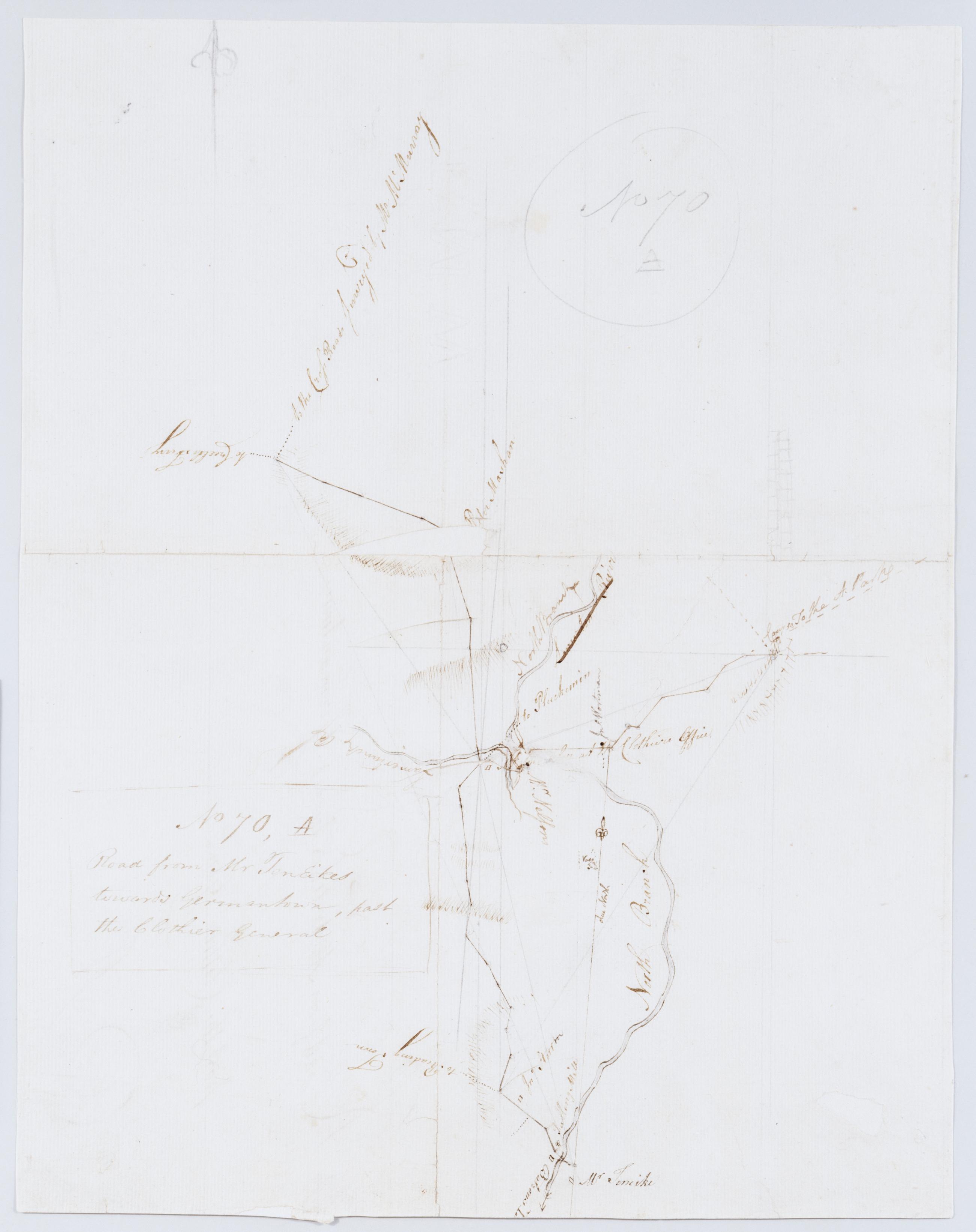
Cartographic Road from Mr TenEikes towards Germantown, past the Clothier General. No 70, A / by Robert Erskine F.R.S. Geogr. A. U.S. and Assistants. Foxed, creased, torn, frayed and abraded. Mounted on cloth, bound and cropped, disbound and silked by subsequent owners. Cleaned after removal of backings 1999; some fill remains. Lined with China paper. Sheathed in mylar. Imperfect: lacking 5 x 1 cm. at map center, 1 x 1 at lower right. In pencil on recto: "No 70 A". Military topographic map. Covers the townships of Bedminster and Bridgewater in Somerset County and of Branchburg in Hunterdon County, New Jersey. Shows roads running through Lamington, Burnt Mill, North Branch and Pluckemin. View Item
Cartographic From Kingston towards Albany. No 93, E / by Robert Erskine F.R.S. Geogr. A. U.S. and Assistants. Foxed, soiled, creased and abraded. Mounted on cloth, bound and cropped, disbound and silked by subsequent owners. Cleaned after removal of backings 1999; some fill remains. Sheathed in mylar. In erased pencil on recto: "No 93 E". In ink on verso: "E E E". Military topographic map. Covers the townships of Ulster and Saugerties in Ulster County, New York. Shows roads running through Kingston, Katrie and Glenerie. Also shows buildings and owners' names, landforms and streams. Pen-and-ink, pencil on laid paper. Shows relief by hachures. View Item
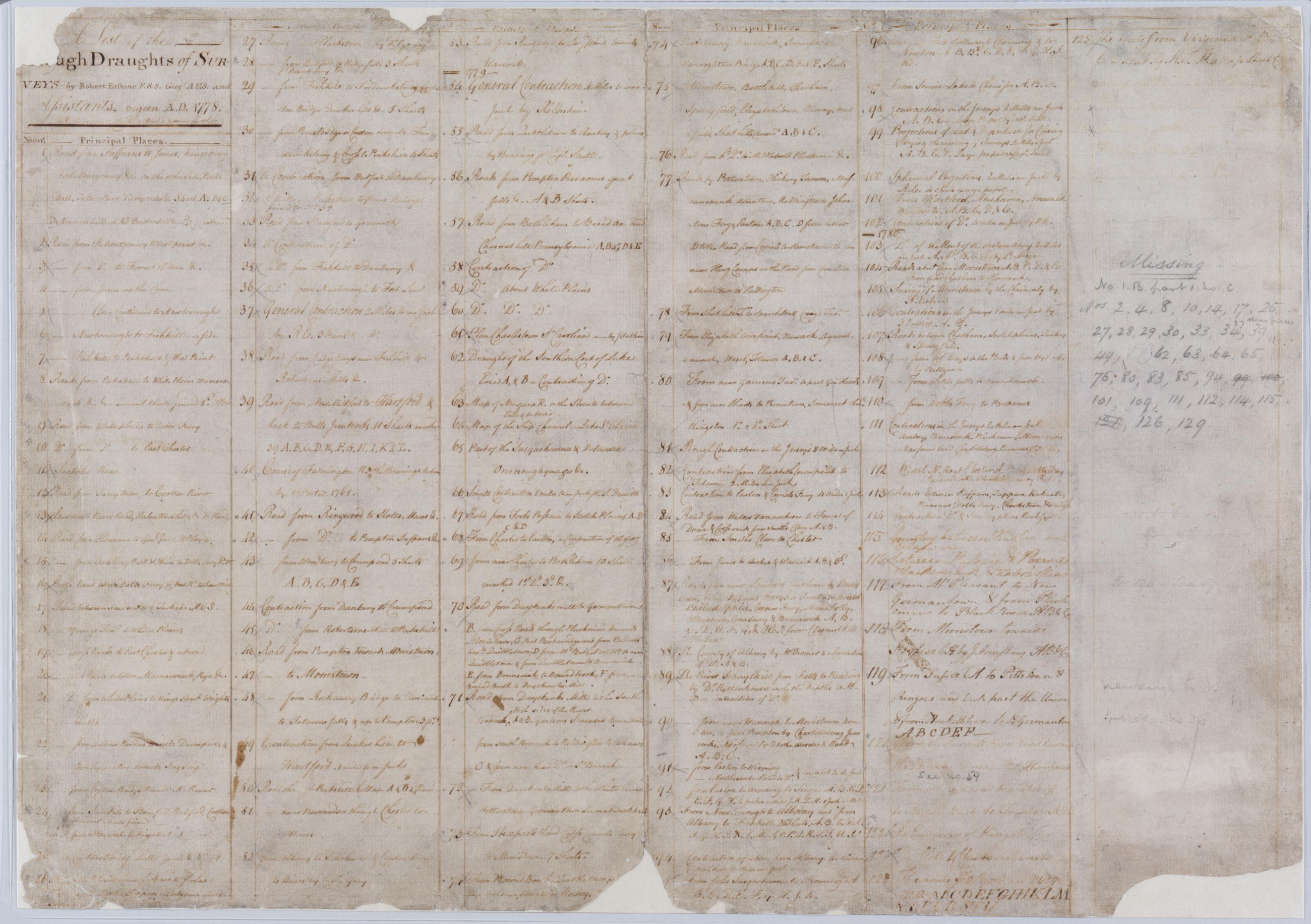
Cartographic A List of the Rough Draughts of Surveys by Robert Erskine F.R.S. Geogr. A. U.S. and Assistants, begun A.D. 1778. Entries through number 114 are in Erskine's hand. Subsequent entries probably by DeWitt, although nos. 115 and 116 have been attributed to Washington by Guthorn. Frayed, split, abraded, stained and soiled, faded. Mounted on cloth, bound and cropped, disbound and silked by subsequent owners. Cleaned after removal of backings 1999; some fill remains. Sheathed in mylar. Imperfect: text lost to fraying and abrasion at three corners, upper and lower margins. Entries 126 through 129 lost to fading but are legible under longwave ultraviolet light. View Item
Cartographic Road from near Genl Wines to Morristown and from sd road to Boonton thence down the Rockaway River until it joins a road surveyd by Mr Lodge. No 90. B / by Robert Erskine F.R.S. Geogr. A. U.S. and Assistants. In pencil on recto: "No 90 B". Military topographic map. Covers the townships of Randolph, Hanover, Morris and Boonton in Morris County, New Jersey. Shows roads running through Dover, Franklin, Morristown, Littleton, Boonton and Montville. Also shows buildings and owners' names, landforms and streams. Pen-and-ink, pencil on laid paper. Shows relief by hachures. Stained, soiled, creased and abraded. Mounted on cloth, bound, disbound and silked by subsequent owners. Cleaned after removal of backings 1999; some fill remains. Sheathed in mylar. View Item
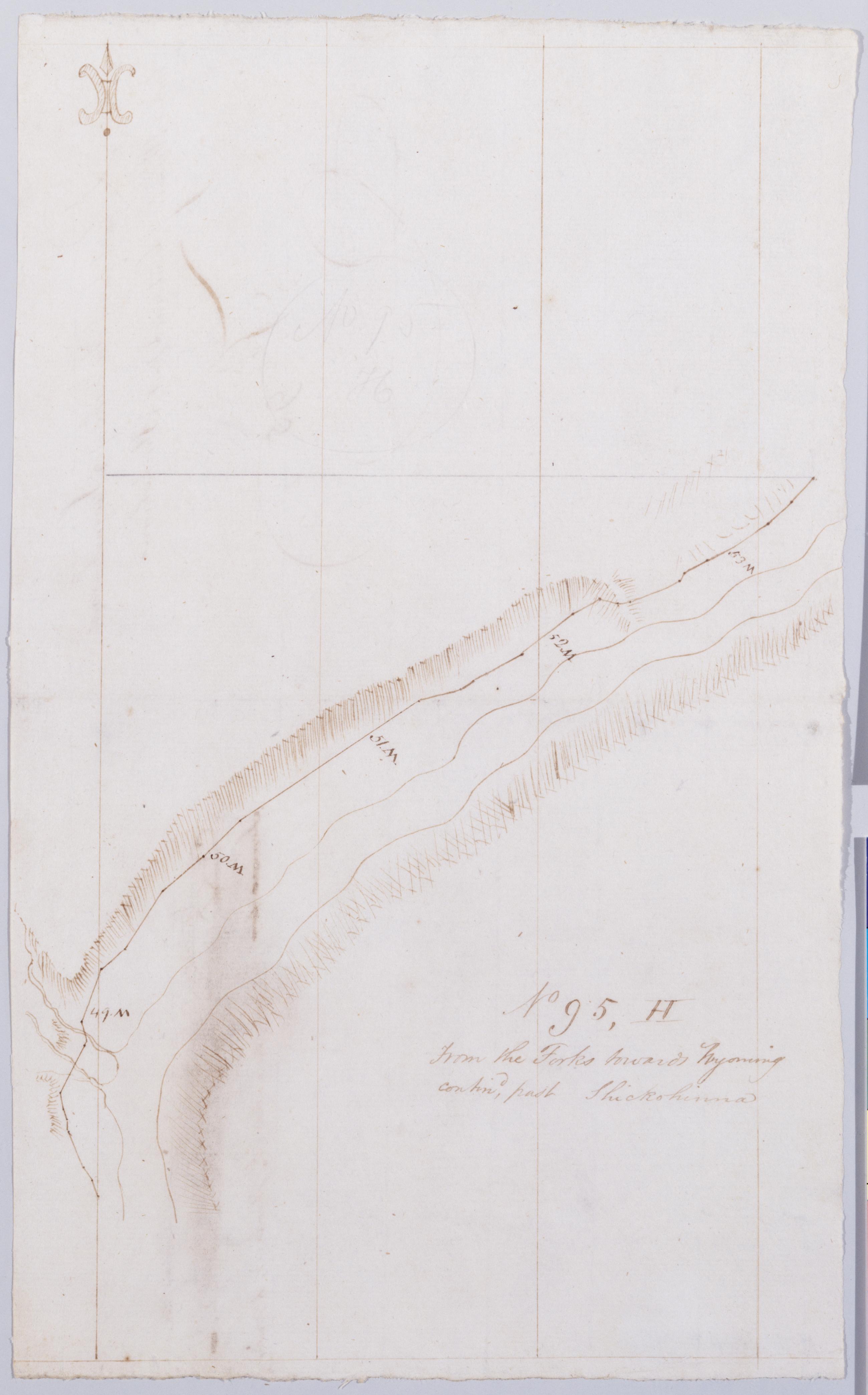
Cartographic From the Forks towards Wyoming contind, past Shickohinna. No 95, H / by Robert Erskine F.R.S. Geogr. A. U.S. and Assistants. In pencil on recto, "No 95 H". Military topographic map. Covers part of Luzerne County in Pennsylvania. Shows roads running through Shickshinny. Also shows landforms and streams. Pen-and-ink, pencil on laid paper. Shows relief by hachures. Soiled, foxed, creased and abraded. Mounted on cloth, bound, disbound and silked by subsequent owners. Cleaned after removal of backings 1999; some fill remains. Sheathed in mylar. Title proper from recto is the work of a later editor--Simeon DeWitt or his assign--subsequent to 1820. Title from verso is in Erskine's hand and may be cited as such. View Item
Cartographic From where a road branches to Middle Bush to Princeton + a little way farther towds Trenton. No 121, A / by Robert Erskine F.R.S. Geogr. A. U.S. and Assistants. Military topographic map. Covers the townships of Princeton in Mercer County, Franklin in Somerset County and South Brunswick in Middlesex County, New Jersey. Shows roads running through Princeton, Kingston, Tenmile Run and Franklin Park. Also shows buildings and owners' names, landforms and streams. Pen-and-ink, pencil on laid paper. Shows relief by hachures. Stained, soiled, creased and abraded. Mounted on cloth, bound and cropped, disbound and silked by subsequent owners. Cleaned after removal of backings 1999; some fill remains. Sheathed in mylar. View Item
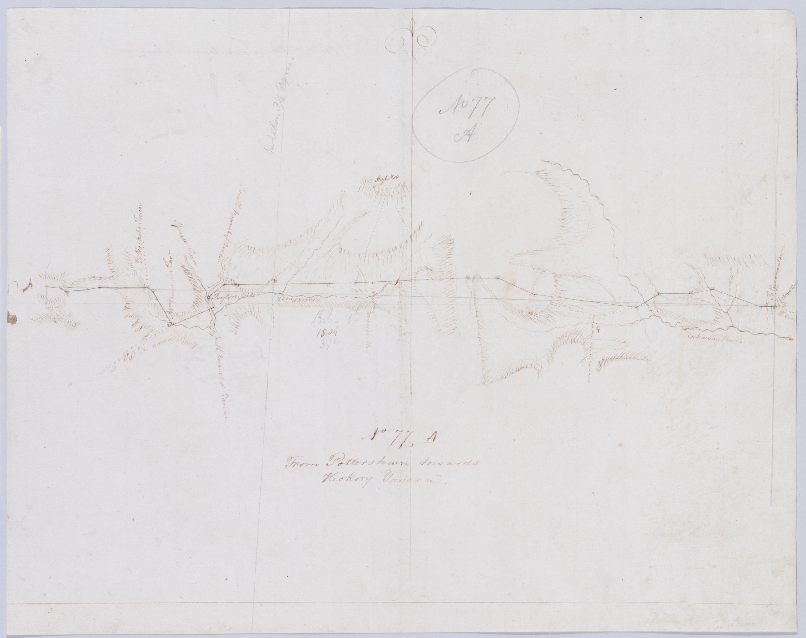
Cartographic From Potterstown towards Hickory Tavern. No 77, A / by Robert Erskine F.R.S. Geogr. A. U.S. and Assistants. In pencil on recto: "No 77 A". Military topographic map. Covers the townships of Clinton and Union in Hunterdon County, New Jersey. Shows roads running through Potterstown, Lebanon and Clinton (formerly Taylors Mills). Also shows buildings and owners' names, landforms and streams. Pen-and-ink, pencil on laid paper. Shows relief by hachures. Stained, foxed, creased and abraded. Mounted on cloth, bound and cropped, disbound and silked by subsequent owners. Cleaned after removal of backings 1999; some fill remains. Sheathed in mylar. View Item
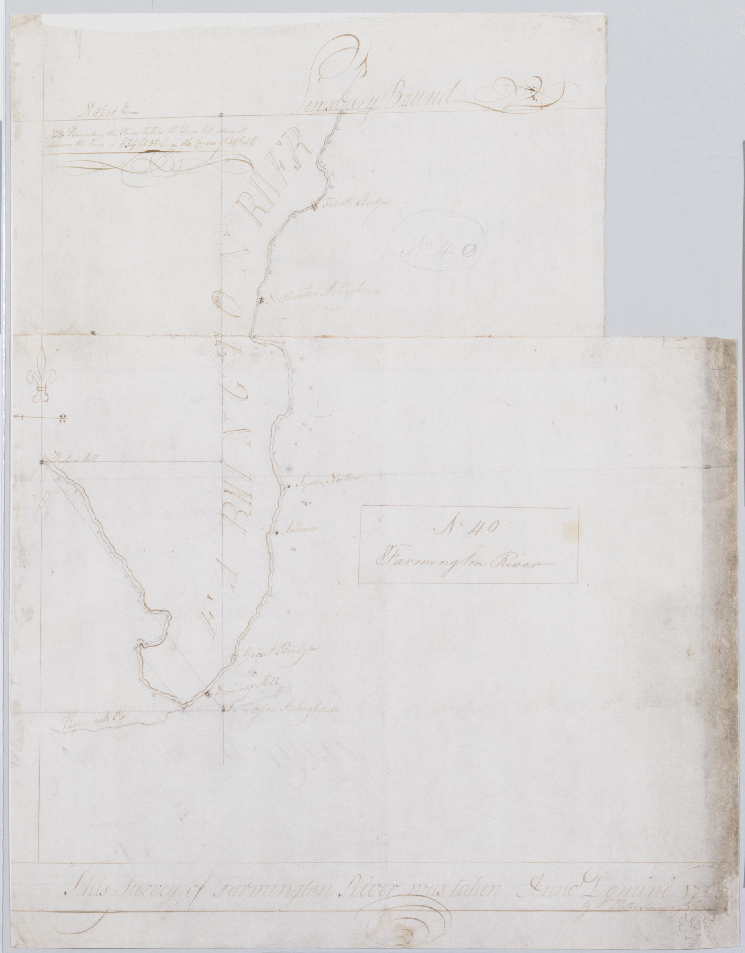
Cartographic Farmington River. No 40 / this survey of Farmington River was taken Anno Domini 1765 by Mr. Porter Surveyor of Farmin[gton] ; by Robert Erskine F.R.S. Geogr. A. U.S. and Assistants ; the bearings taken by Mr. Porter. Handwriting examination shows that this is a copy by Erskine of Porter's original. In pencil on recto: "No 40". Military topographic map. Covers the towns of Simsbury, Avon and Farmington in Hartford County, Connecticut. Shows buildings and owners' names, course of the river. Pen-and-ink, pencil on laid paper. Stained, frayed, and abraded. Mounted on cloth, bound and cropped, disbound and silked by subsequent owners. Cleaned after removal of backings 1999; some fill remains. Sheathed in mylar. View Item
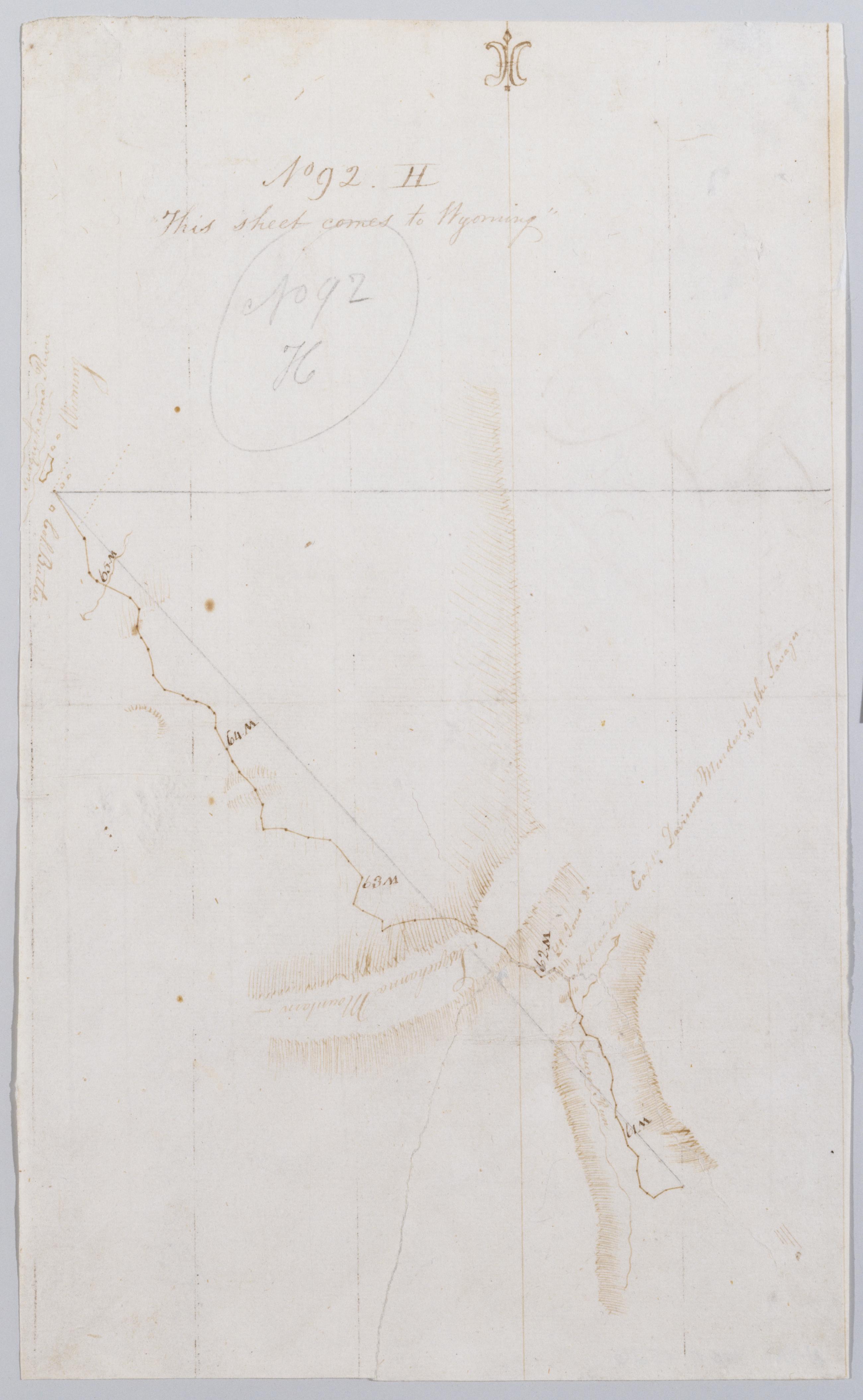
Cartographic This sheet comes to Wyoming. No 92, H / by Robert Erskine F.R.S. Geogr. A. U.S. and Assistants. Creased, foxed, stained, soiled, torn and abraded. Mounted on cloth, bound and cropped, disbound and silked by subsequent owners. Cleaned after removal of backings 1999; some fill remains. Sheathed in mylar. In pencil on recto: "No 92 H". Includes map label: "Capt. Davison Murdered by the Savages". Military topographic map. Covers Luzerne County, Pennsylvania. Shows roads running through Wyoming Valley and Ridgewood. Also shows buildings and owners' names, landforms and streams.Pen-and-ink, pencil on laid paper. Paper itself is imperfect. View Item
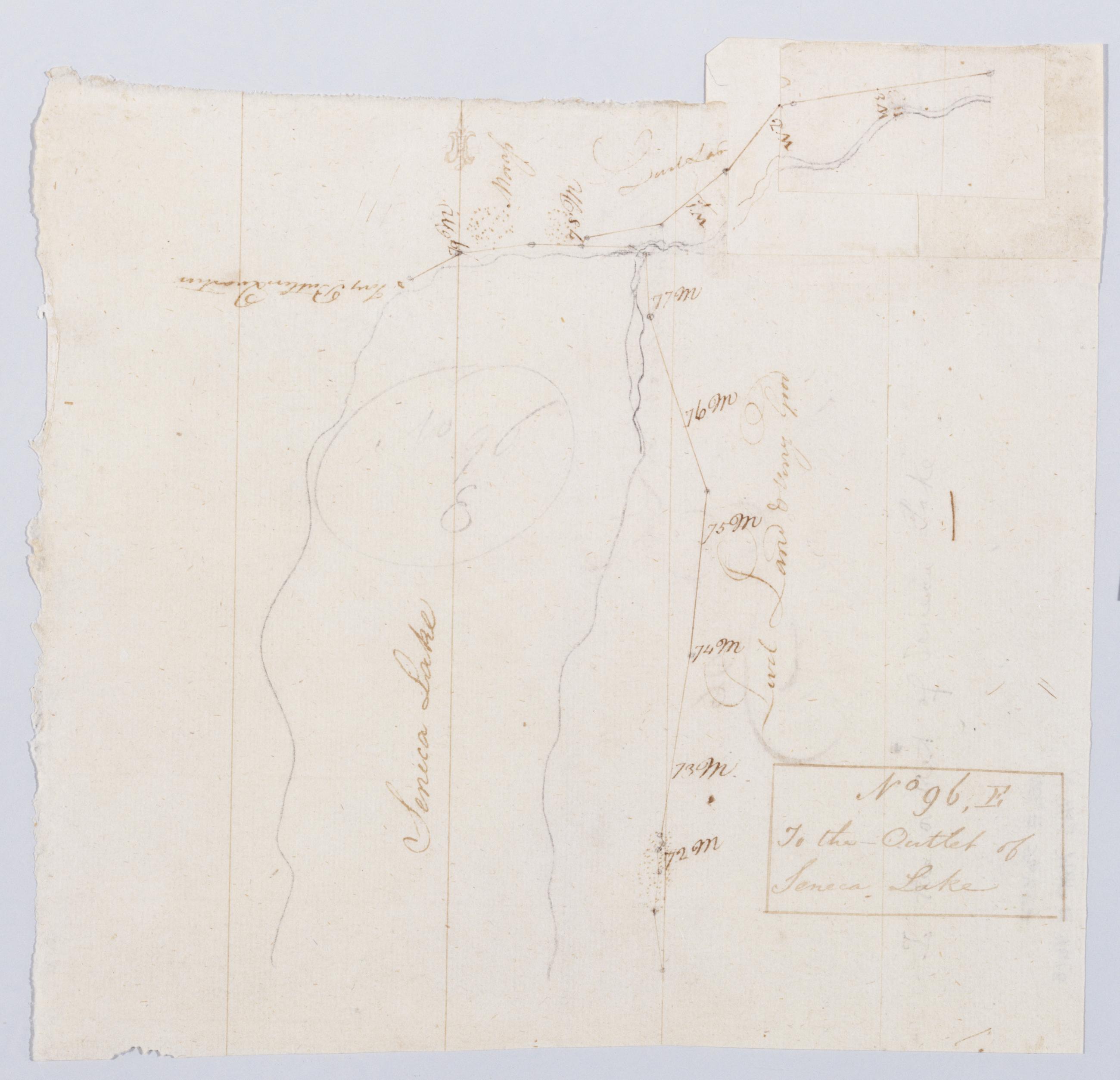
Cartographic To the Outlet of Seneca Lake. No 96, E / by Robert Erskine F.R.S. Geogr. A. U.S. and Assistants. In erased pencil on recto, "No 96 E". Military topographic map. Covers the towns of Waterloo and Fayette in Seneca County and of Geneva in Ontario County, New York. Shows roads running through Geneva. Also shows landforms and streams. Pen-and-ink, pencil on laid paper. Paper extended at upper right. Scale statement from verso of sheet 96,A. Shows relief by hachures. Soiled, stained, creased and abraded. Mounted on cloth, bound, disbound and silked by subsequent owners. Cleaned after removal of backings 1999; some fill remains. Sheathed in mylar. View Item
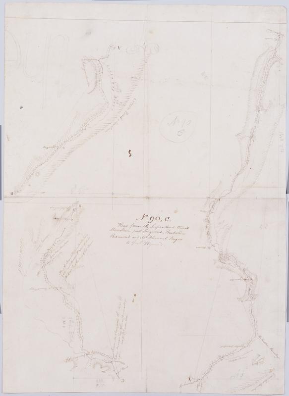
Cartographic Road from the Sussex Road towards Morris Town past Longwood, Burkshire Beaman's and Mt Pleasant Forges to Genl Wynes's. No 90, C / by Robert Erskine F.R.S. Geogr. A. U.S. and Assistants. In pencil on recto: "No 90 C". Military topographic map in three segments meant to meet at points marked "A" and "B." Map covers the townships of Hardiston, Jefferson, Rockaway and Vernon in Morris County, New Jersey. Shows roads running through Vernon, Williams Mine, Stockholm, Milton, Berkshire Valley, Spicertown and Dover. Also shows buildings and owners' names, landforms and streams. Pen-and-ink, pencil on laid paper. Shows relief by hachures. Stained, foxed, creased and abraded. Mounted on cloth, bound, disbound and silked by subsequent owners. View Item
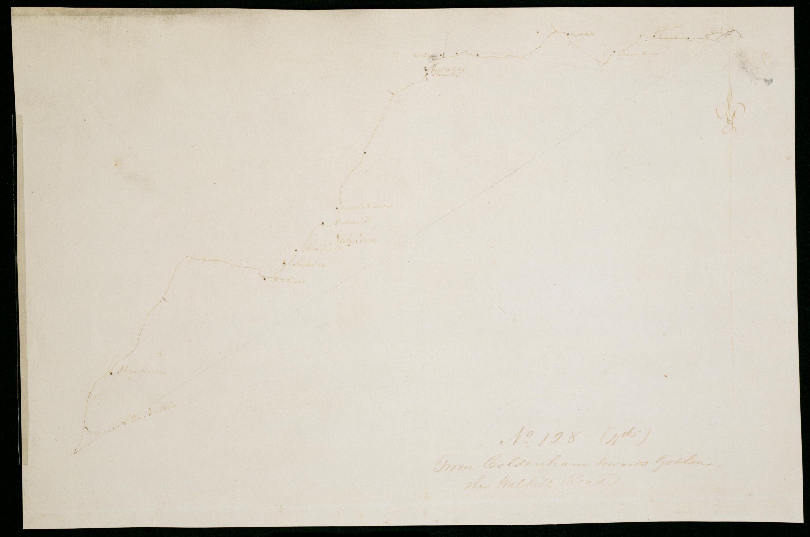
Cartographic From Coldenham towards Goshen the Walkill Road. No 128 (4th) / by Robert Erskine F.R.S. Geogr. A. U.S. and Assistants. Date probably 1782, based on association with sheet 128,1st. Military topographic map. Covers the townships of Montgomery and Hamptonburg in Orange County, New York. Shows roads running through Coldenham, Berea, Neelytown and Lagrange. Also shows buildings and owners' names. Pen-and-ink, pencil on laid paper. Soiled and abraded. Mounted on cloth, bound and cropped, disbound and silked by subsequent owners. Cleaned after removal of backings 1999; some fill remains. Sheathed in mylar. Title proper from recto is the work of a later editor--Simeon DeWitt or his assign--subsequent to 1820. View Item
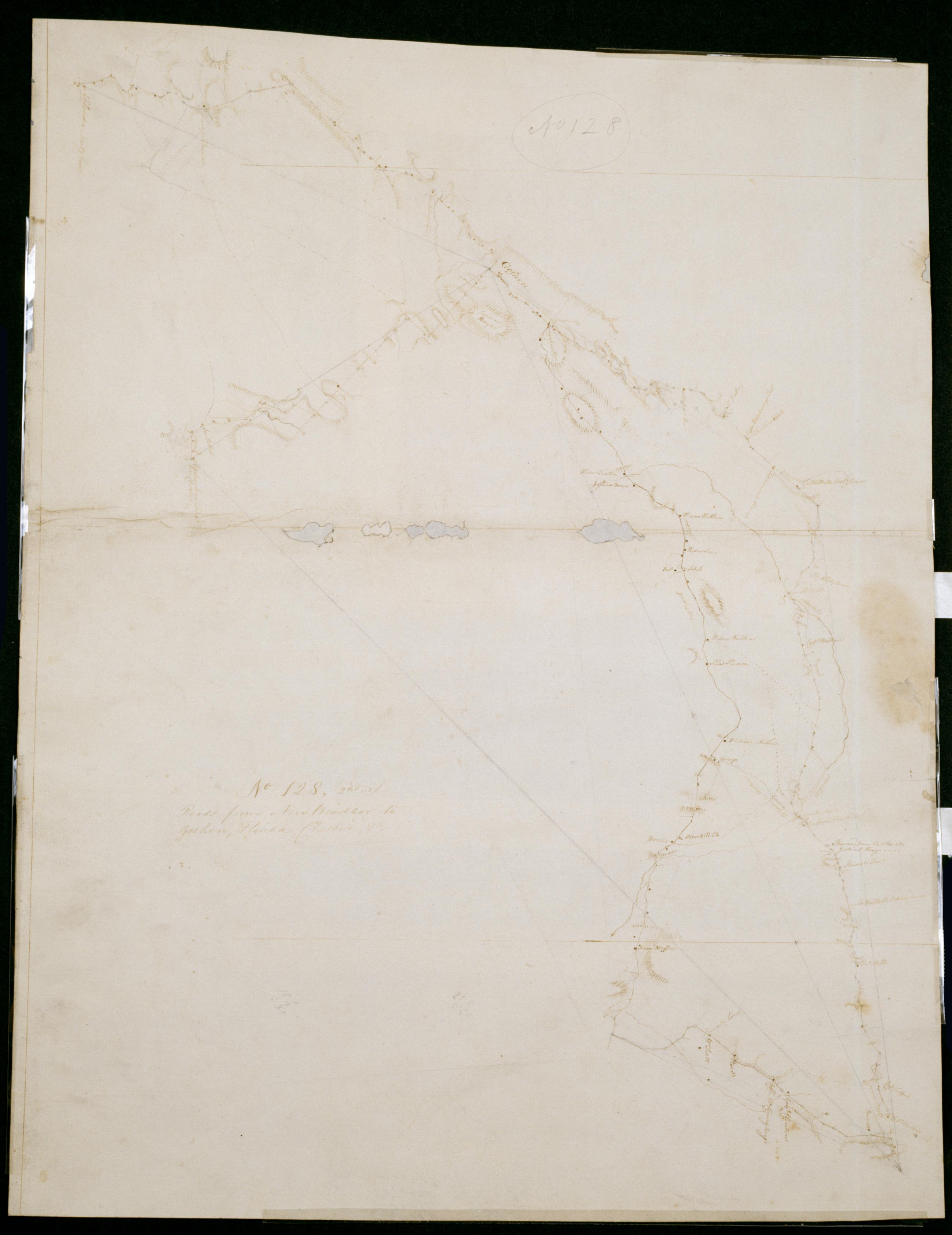
Cartographic Roads from New Windsor to Goshen, Florida, Chester, +c. No 128, (2nd) / by Robert Erskine F.R.S. Geogr. A. U.S. and Assistants. Date probably 1782, based on association with sheet 128,1st. Imperfect: lacking small fragments along crease line. In pencil on recto: "No 128". Military topographic map. Covers the townships of Hamptonburg, Blooming Grove, New Windsor and Goshen in Orange County, New York. Shows roads running thorugh Florida, Mapes Corners, Howell, Goshen, East Chester, Campbell Hall, Hamptonburg, Girard, Otterkill, Washingtonville and Little Britain. Also shows buildings and owners' names, landforms and streams. Oriented with north to right of sheet. Pen-and-ink, pencil on laid paper. View Item
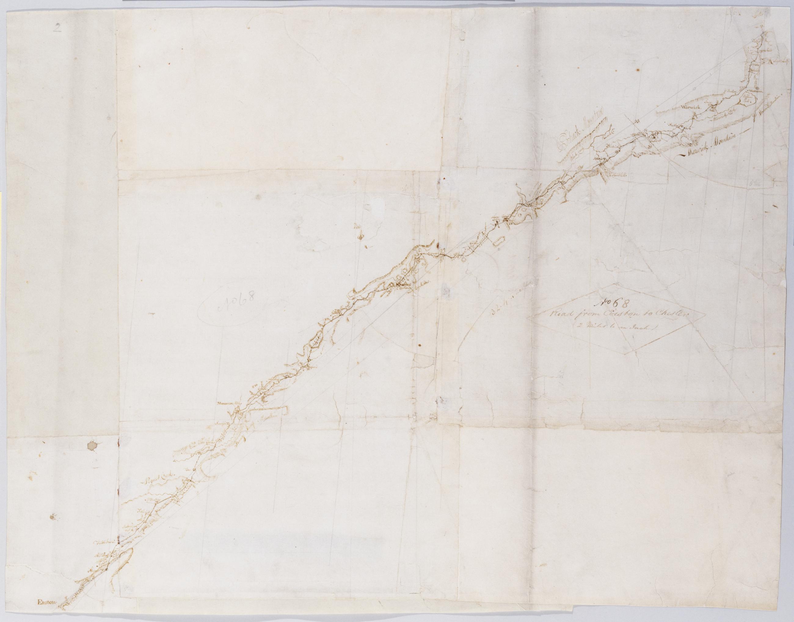
Cartographic Road from Easton to Chester (2 Miles to an Inch). No 68 / by Robert Erskine F.R.S. Geogr. A. U.S. and Assistants. Military topographic map. Covers Orange County in New York and Sussex and Warren counties in New Jersey. Shows roads running through East Chester, Sugarloaf, Warwick and New Milford in New York; and Maple Grange, Vernon, Hamburg, North Church, Newton (formerly Sussex), Hope, Swayze Mills, Oxford Church and Phillipsburg in New Jersey. Also shows buildings and owners' names, landforms and streams. Pen-and-ink, pencil on 3 assembled pieces laid paper; 4 pieces having a wove finish added later. Shows relief by hachures. Stained, foxed, creased, torn, frayed and abraded. View Item
Cartographic From Newborough towds Albany (to Kingston) No 93, D / by Robert Erskine F.R.S. Geogr. A. U.S. and Assistants. In ink on verso: "D D [D]". In pencil on recto: "No 93 D". Military topographic map. Covers the township of Esopus in Ulster County, New York. Shows roads running through Espous, Ulster Park, Port Ewen and Kingston. Also shows buildings and owners' names, landforms and streams. Pen-and-ink, pencil on laid paper. Shows relief by hachures. Stained, soiled, creased and abraded. Mounted on cloth, bound and cropped, disbound and silked by subsequent owners. Cleaned after removal of backings 1999; some fill remains. Sheathed in mylar. View Item
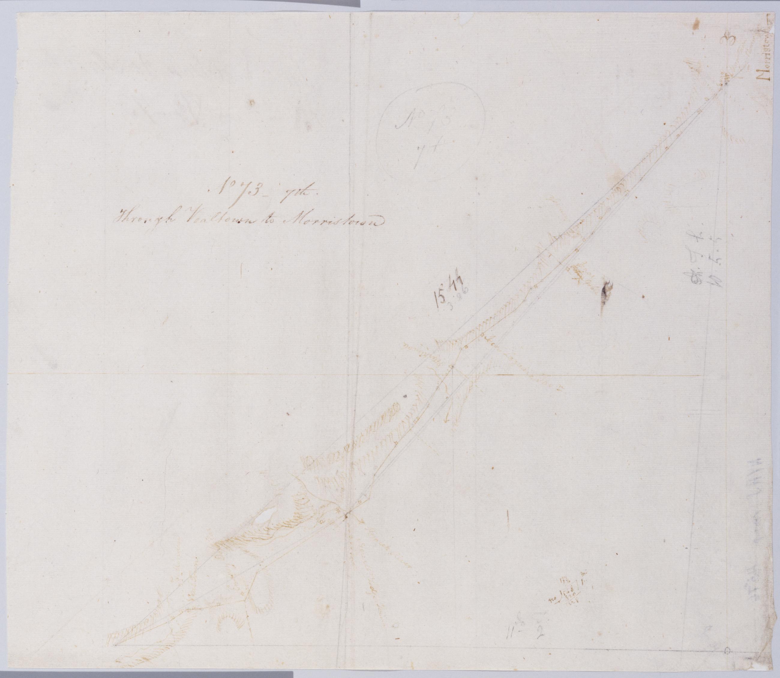
Cartographic Through Vealtown to Morristown. No 73, 7th / by Robert Erskine F.R.S. Geogr. A. U.S. and Assistants. Foxed, creased, frayed and abraded. Mounted on cloth, bound and cropped, disbound and silked by subsequent owners. Cleaned after removal of backings 1999; some fill remains. Sheathed in mylar. In pencil on recto: "No 73 7th". Military topographic map. Covers the township of Bernard in Somerset County and that of Morris in Morris County, New Jersey. Shows roads running through Bernardsville and Morristown. Also shows buildings and owners' names, landforms and streams. Pen-and-ink, pencil on laid paper. Shows relief by hachures. View Item
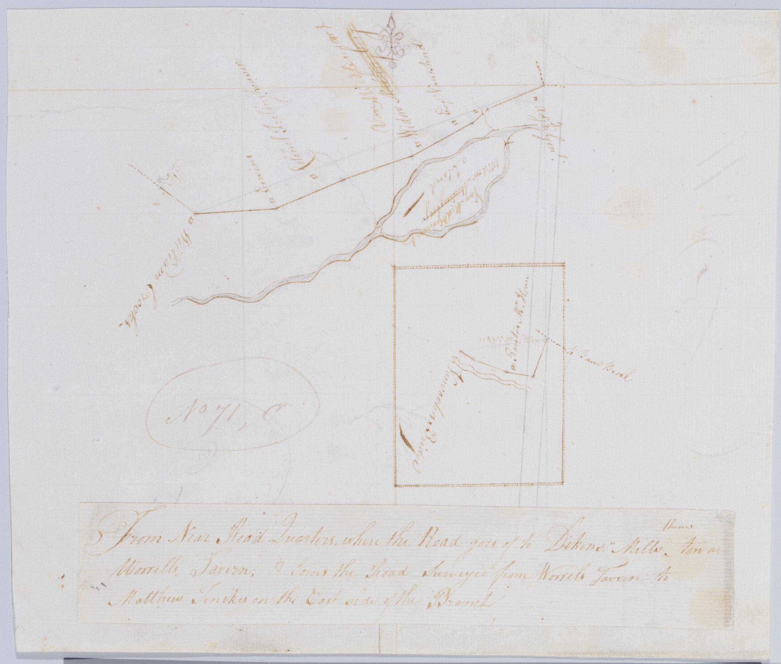
Cartographic From Near Head Quarters where the Road goes of thence to Dikins' Mills toward Worrells Tavern, & Joins the Road Surveyed from Worrels Tavern to Matthew Tenikes on the East side of the Branch. No 71, C / by Robert Erskine F.R.S. Geogr. A. U.S. and Assistan In ink on verso: "C - N 71". Inset map apparently covers a small area two minutes east of that covered by the main map; Vanvactors Bridge seems to have been located on the Raritan River at W 74⁰35ʹ. Military topographic map. Covers the townships of Hillsboro and Bridgewater in Somerset County, New Jersey. Show roads running through Raritan village; also buildings and owners' names, landforms and streams. Pen-and-ink, pencil on laid paper. Title on a separate piece pasted atop sheet. Shows relief by hachures. Stained and abraded. View Item
Cartographic Cross Roads to East Chester, and above. No 19 / by Robert Erskine F.R.S. Geogr. A. U.S. and Assistants. Foxed, creased, frayed, and abraded. Mounted on cloth, bound and cropped, disbound and silked by subsequent owners. Cleaned after removal of backings 1999; some fill remains. Sheathed in mylar. In ink on verso: "No. 19". Military topographic map. Covers southern Westchester County and the Bronx, New York. Shows roads running through East Chester in the Bronx, New Rochelle, Larchmont and Mamaronek; also Tuckahoe and Scarsdale. Also shows buildings and owners' names, landforms and streams. Pen-and-ink, pencil on laid paper. Scale roughly estimated. Shows relief by hachures. View Item
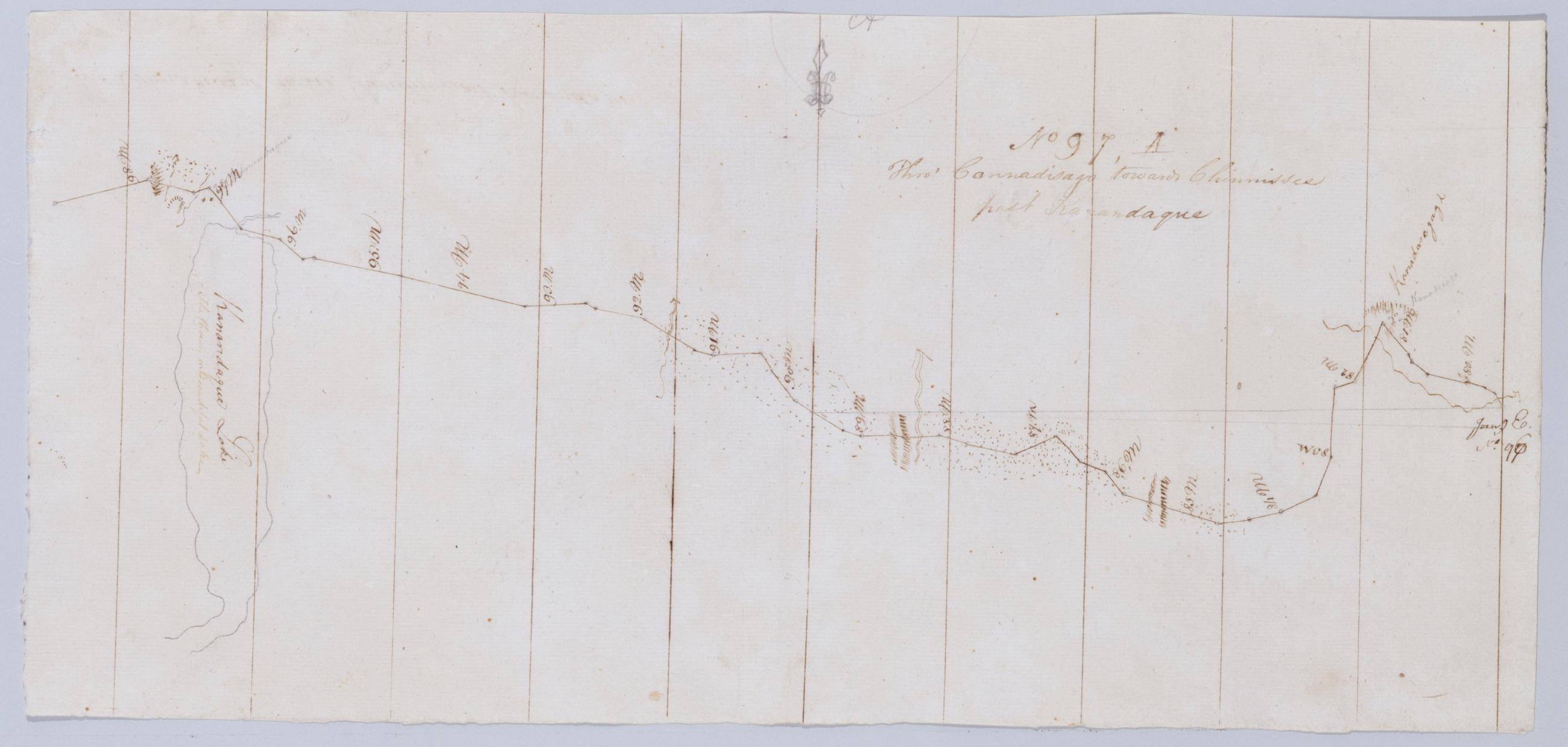
Cartographic Thro' Connadisago towards Chinnissee past Ka[n]andague. No 97, A / by Robert Erskine F.R.S. Geogr. A. U.S. and Assistants. In erased pencil on recto, "... A". Military topographic map. Covers the towns of Geneva, Seneca, Hopewell and Canandaigua in Ontario County, New York. Shows roads running through Geneva, Flint, Hopewell and Canandigua. Also shows landforms and streams. Pen-and-ink, pencil on laid paper. Shows relief by hachures. Stained, creased and abraded. Mounted on cloth, cropped, bound, disbound and silked by subsequent owners. Cleaned after removal of backings 1999; some fill remains. Sheathed in mylar. View Item
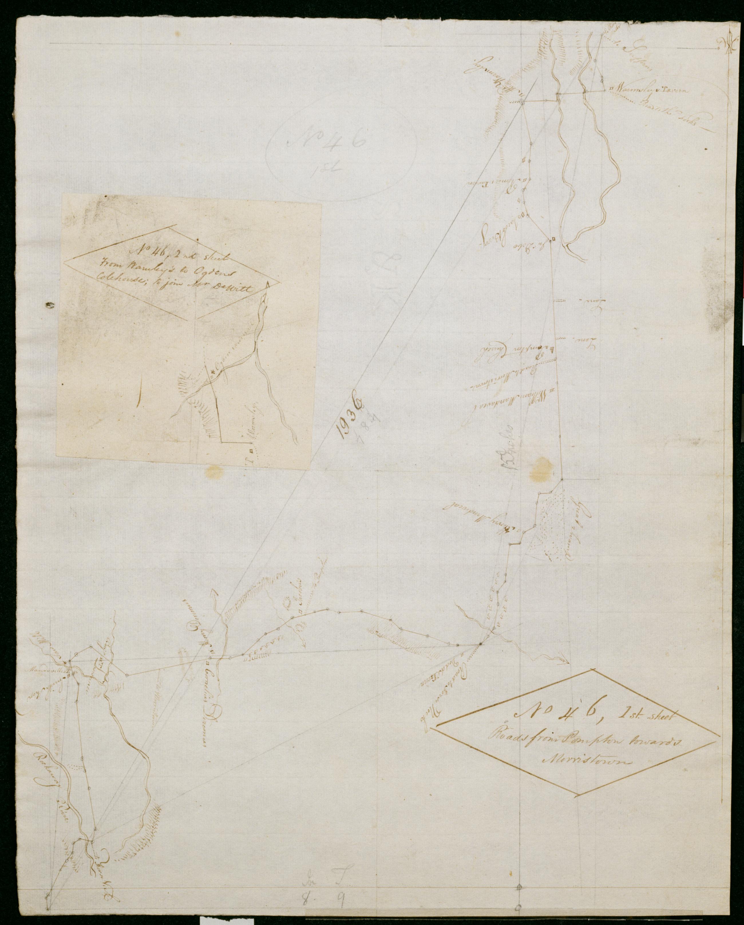
Cartographic Roads from Pompton towards Morristown. No 46, 1st sheet ; From Warmley's to Ogdens Colehouse, to join Mr. DeWitt. No 46, 2nd sheet / by Robert Erskine F.R.S. Geogr. A. U.S. and Assistants. Foxed, creased, frayed, and abraded. Mounted on cloth, bound and cropped, disbound and silked by subsequent owners. Cleaned after removal of backings 1999; some fill remains. Sheathed in mylar. In pencil on recto: "No 46 1st". Military topographic map. Covers the townships of Pequannc and Montville in Morris County, Pompton and Wayne in Passaic County and Caldwell in Essex County, New Jersey. Shows roads running through Pompton Lakes, Pompton, Lincoln Park and Montville. Also shows buildings and owners' names, landforms and streams. Pen-and-ink, pencil on laid paper. View Item
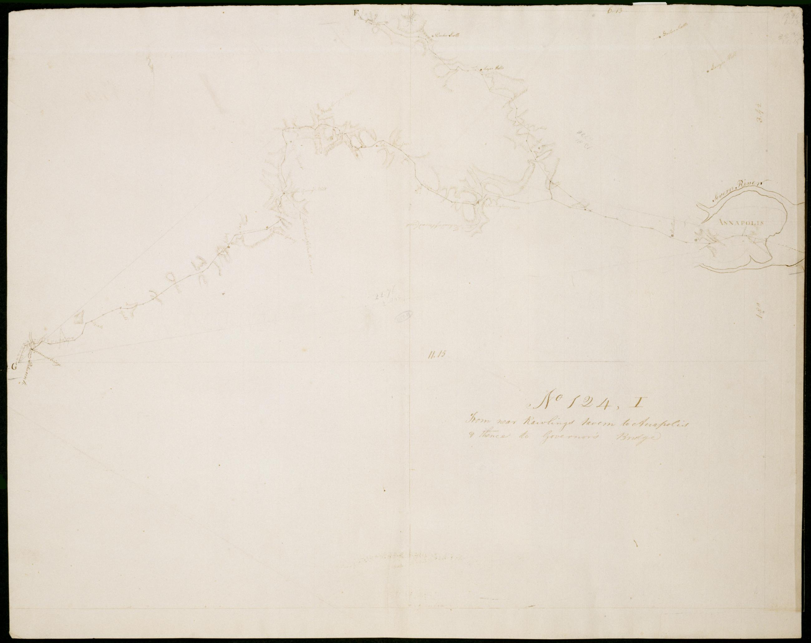
Cartographic From near Rawlings tavern to Anapolis + thence to Governor's Bridge. No 124, I / by Robert Erskine F.R.S. Geogr. A. U.S. and Assistants. Date 1781 inferred by cataloger. Military topographic map. Covers the counties of Anne Arundel and Prince Georges in Maryland. Shows roads running through Crownsville, Annapolis, Chesterfield, Lavall and Patuxent River Park. Also shows buildings, landforms and streams. Pen-and-ink, pencil on laid paper. Shows relief by hachures. Soiled, creased and abraded. Mounted on cloth, bound and cropped, disbound and silked by subsequent owners. Cleaned after removal of backings 1999; some fill remains. Sheathed in mylar. View Item
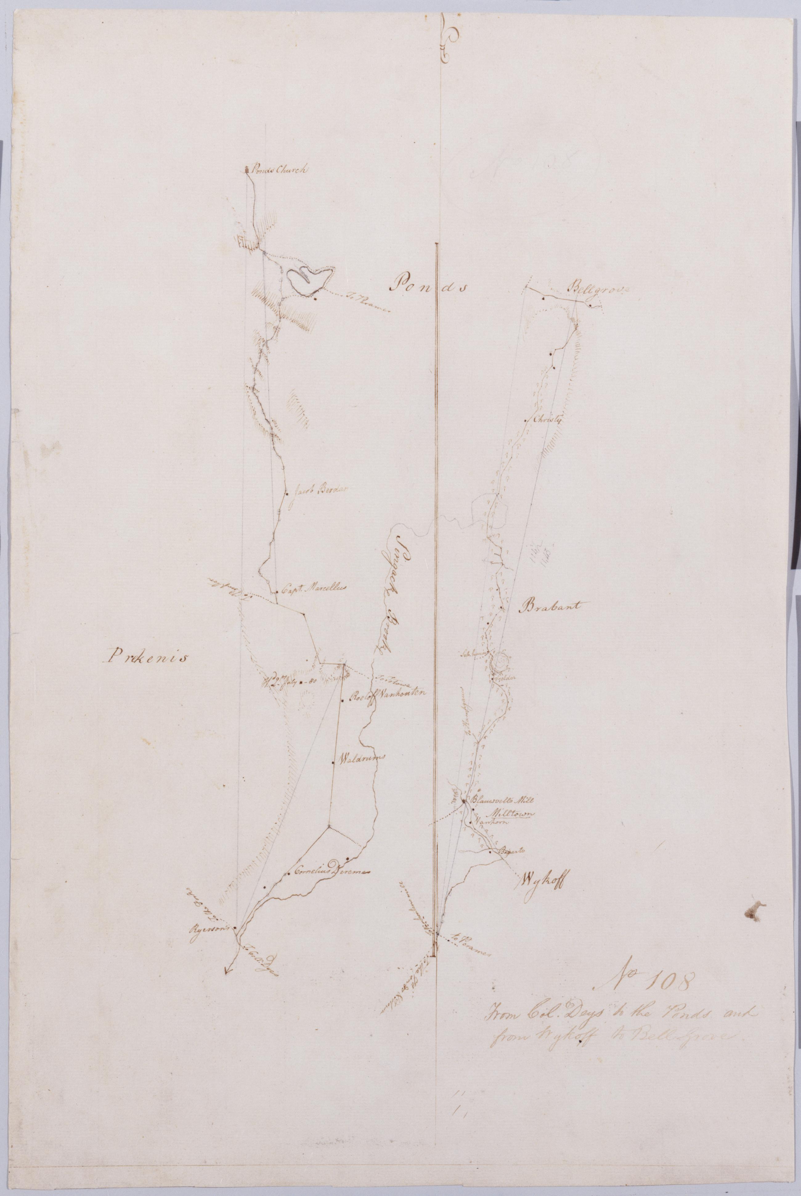
Cartographic From Col Dey's to the Ponds & from Wykoff to Bell Grove. No 108 / by Robert Erskine F.R.S. Geogr. A. U.S. and Assistants. In pencil on recto: "No 108". Military topographic maps. The left, Col. Dey's to the Ponds, covers the townships of Wayne and Frankline in Passaic County, New Jersey. The right, Wykoff to Bell Grove, covers the townships of Hohokus and Franklin in Bergen County, New Jersey. Both show buildings and owners' names, landforms and streams. Pen-and-ink, pencil on laid paper. Shows relief by hachures. Soiled, creased and abraded. Mounted on cloth, bound and cropped, disbound and silked by subsequent owners. Cleaned after removal of backings 1999; some fill remains. Sheathed in mylar. View Item
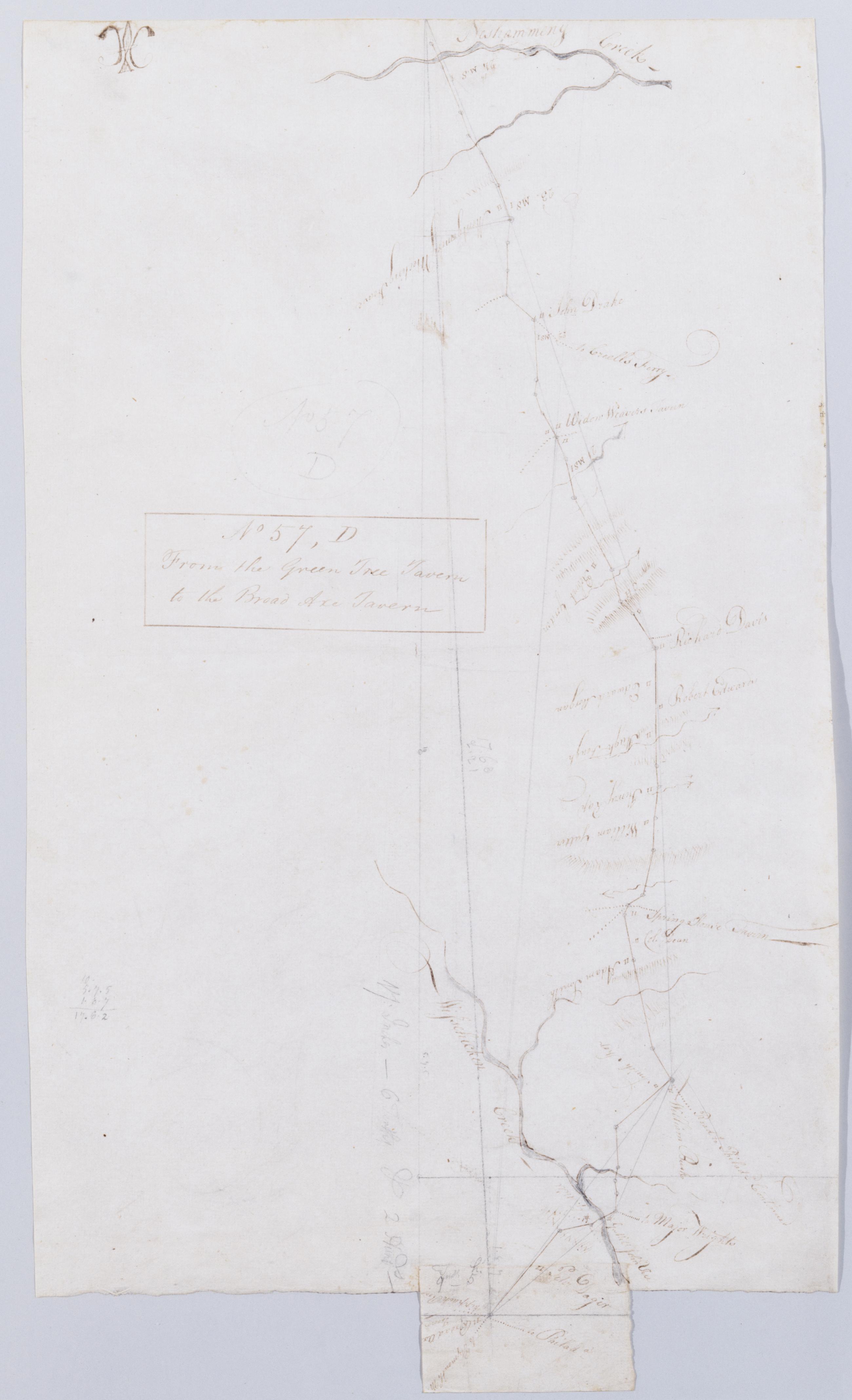
Cartographic From the Green Tree Tavern to the Broad Axe Tavern. No 57, D / by Robert Erskine F.R.S. Geogr. A. U.S. and Assistants. Foxed, creased and abraded. Mounted on cloth, bound and cropped, disbound and silked by subsequent owners. Cleaned after removal of backings 1999; some fill remains. Sheathed in mylar. In pencil on recto: "57 D". Military topographic map. Covers Montgomery County, Pennsylvania. Shows roads running through Trewigtown, Colmar, Montgomeryville, Spring House, Ambler and Fort Washington. Also shows buildings and owners' names, landforms and streams. Pen-and-ink, pencil on laid paper. Second sheet is a mere 5 x 8 cm. tab at lower margin of main sheet. Shows relief by hachures. View Item
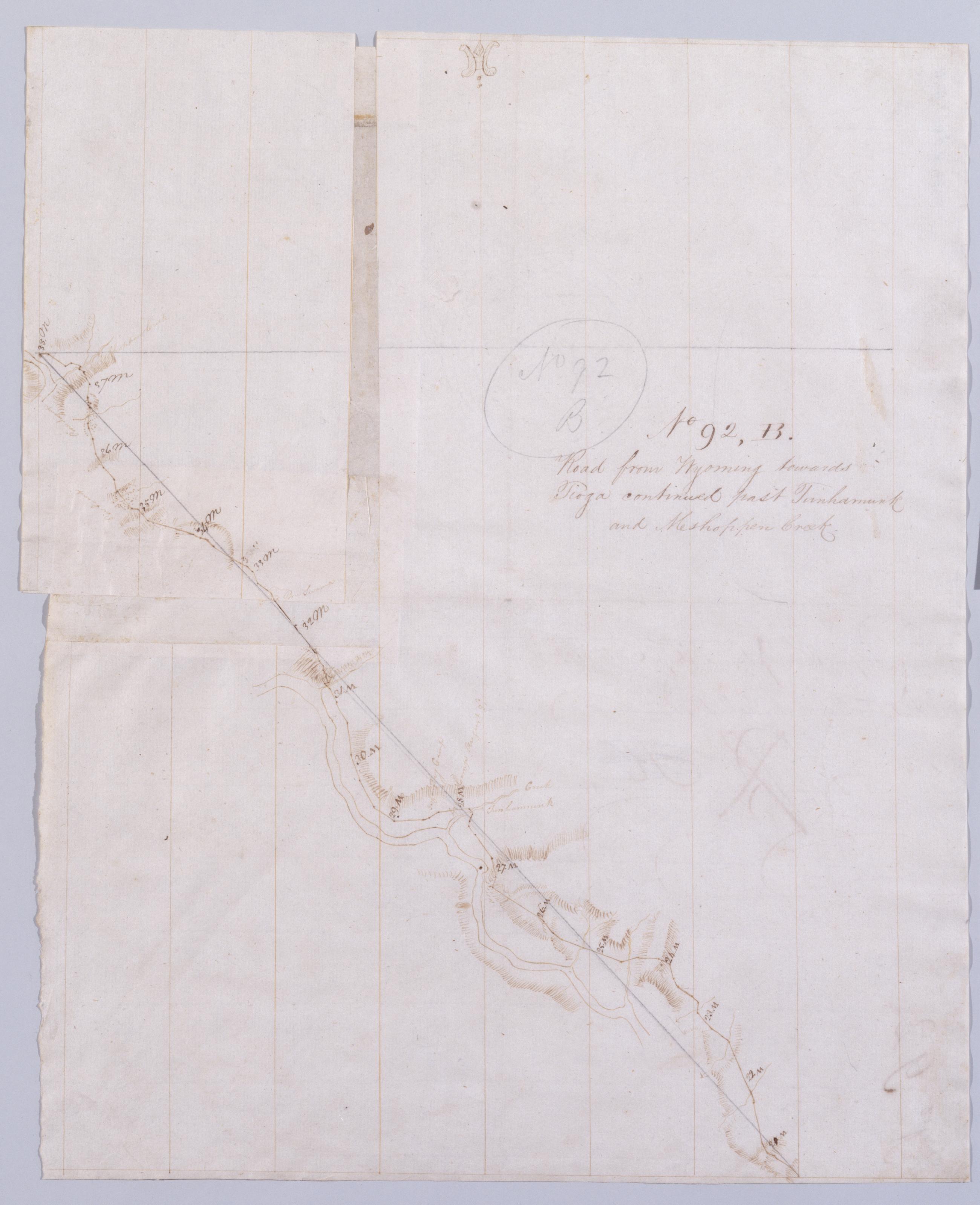
Cartographic Road from Wyoming towards Tioga continued past Tunhamunk and Meshoppen Creek. No 92, B [sic] / by Robert Erskine F.R.S. Geogr. A. U.S. and Assistants. In pencil on recto: "No 92 B". Military topographic map. Covers Wyoming County, Pennsylvania. Shows roads running through Tunkhannock and Meshoppen. Also shows buildings and owners' names, landforms and streams. Number accompanying verso title written in different ink. Letter B crossed out using ink and replaced by K, which in turn is crossed out using pencil and replaced by B. Based on scale and situation, K is the correct letter. Pen-and-ink, pencil on laid paper--one sheet cut and reassembled using two scraps for backing. Scale from index title; confirmed by measuring the map itself. View Item
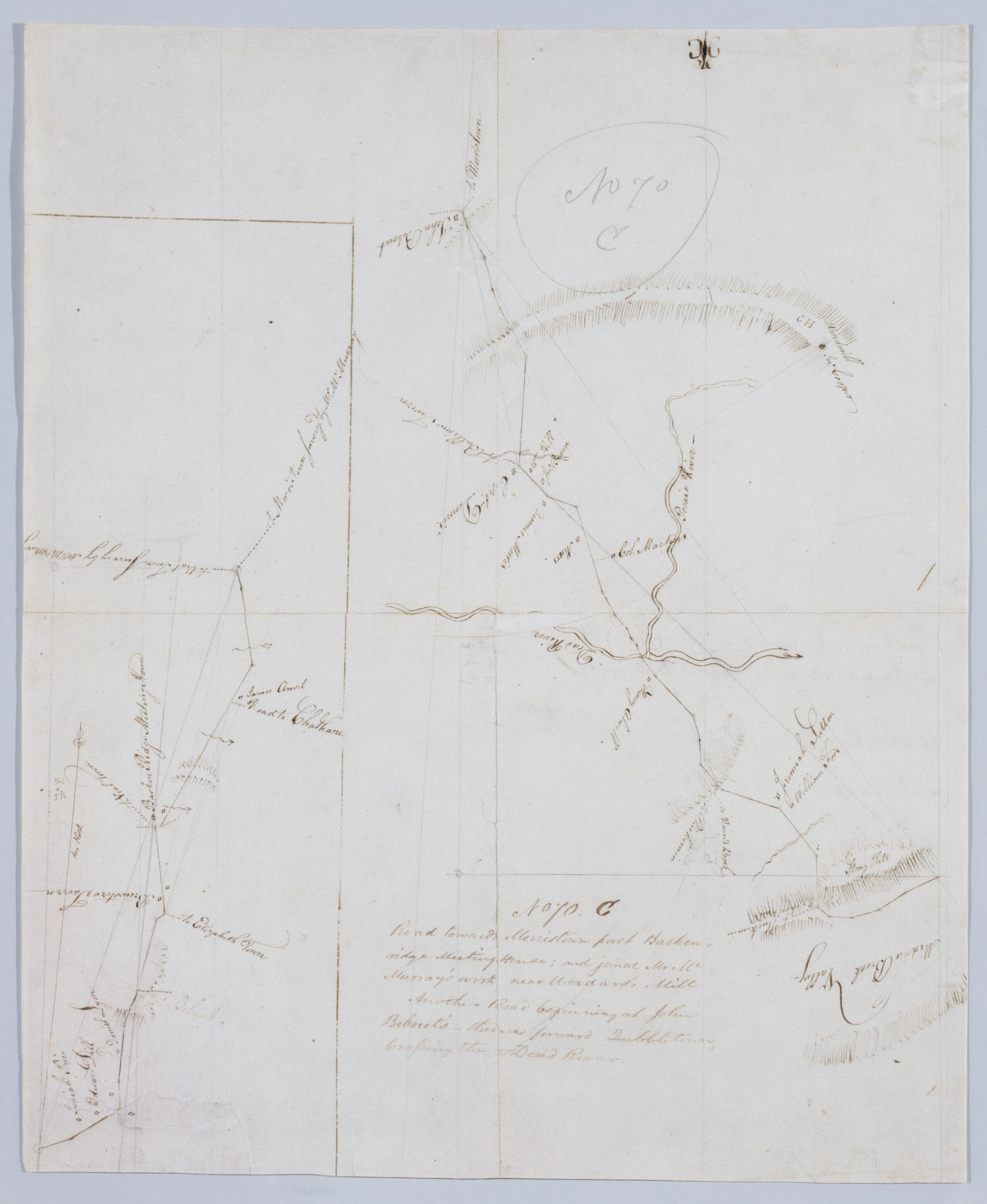
Cartographic Road towards Morristown past Baskenridge Meeting House; and joined Mr. McMurray's work near Woodard's Mill ; Another Road beginning at John Bebout's, thence toward Quibbletown, Crossing the Dead River. No 70. C by Robert Erskine F.R.S. Geogr. A. U.S. and Foxed, creased, torn, frayed and abraded. Mounted on cloth, bound and cropped, disbound and silked by subsequent owners. Cleaned after removal of backings 1999; some fill remains. Sheathed in mylar. Imperfect: lacking 1 x 2 cm. at map center. In pencil on recto: "No 70 C". Military topographic maps. The lefthand, smaller map covers the township of Bernard in Somerset County, New Jersey; it shows roads running through Madisonville and Basking Ridge. The larger map covers the townships of Bernard, Warren and North Plainfield in the same county; it shows roads running through Lyons and Mt. View Item