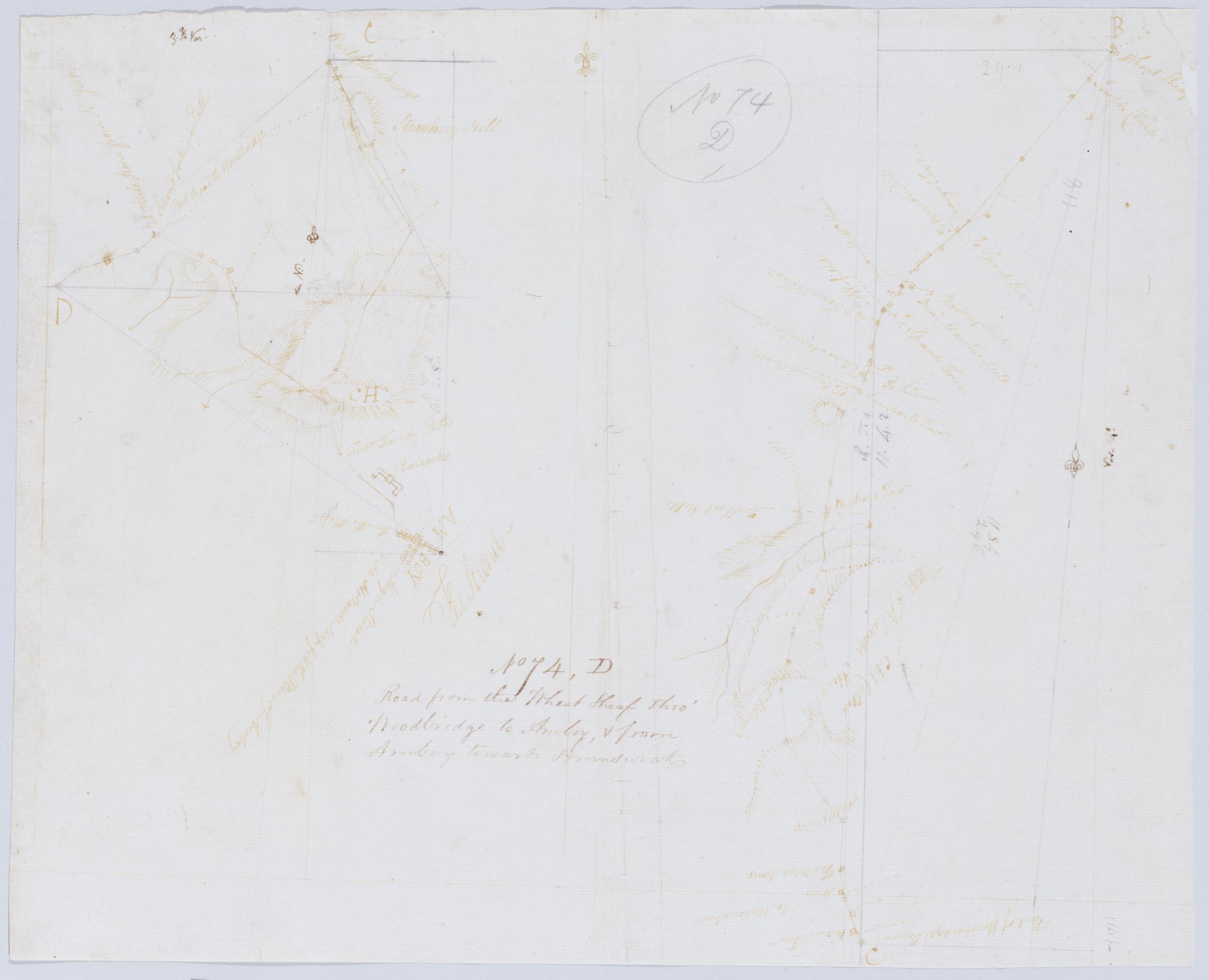
Cartographic Road from the Wheat Sheaf thro' Woodbridge to Amboy + from Amboy towards Brunswick. No 74 D / by Robert Erskine F.R.S. Geogr. A. U.S. and Assistants. Foxed- creased- frayed and abraded. Mounted on cloth- bound and cropped- disbound and silked by subsequent owners. Cleaned after removal of backings 1999; some fill remains. Sheathed in mylar. In pencil on recto: "No 74 D". Military topographic map; righthand segment fits north of the lefthand one. Map covers the townships of Rahway and Linden in Union County and of Woodbridge in Middlesex County- New Jersey. Shows roads running through Wheatsheaf- Rahway- Demorest- Woodbridge- Spa Spring- Amboy- Fairfield Union and Valentine Fords. View Item
Cartographic Road from Norris's Tavern in Morristown past the Park of Artillery to Genl Knoxs Quarters. No 104 D / by Robert Erskine F.R.S. Geogr. A. U.S. and Assistants. Military topographic map. Covers part of Morristown in Morris County- New Jersey. Shows buildings and owners' names- landforms and streams. Shows relief by hachures. Title proper from recto is the work of a later editor--Simeon DeWitt or his assign--subsequent to 1820. Title from verso is in Erskine's hand and may be cited as such; it has been damaged by cropping. Index title- statement of responsibility- date- series title and series numbering also by Erskine- but on separate index sheet filed at head of series. Pen-and-ink- pencil on laid paper. Watermark: none. View Item
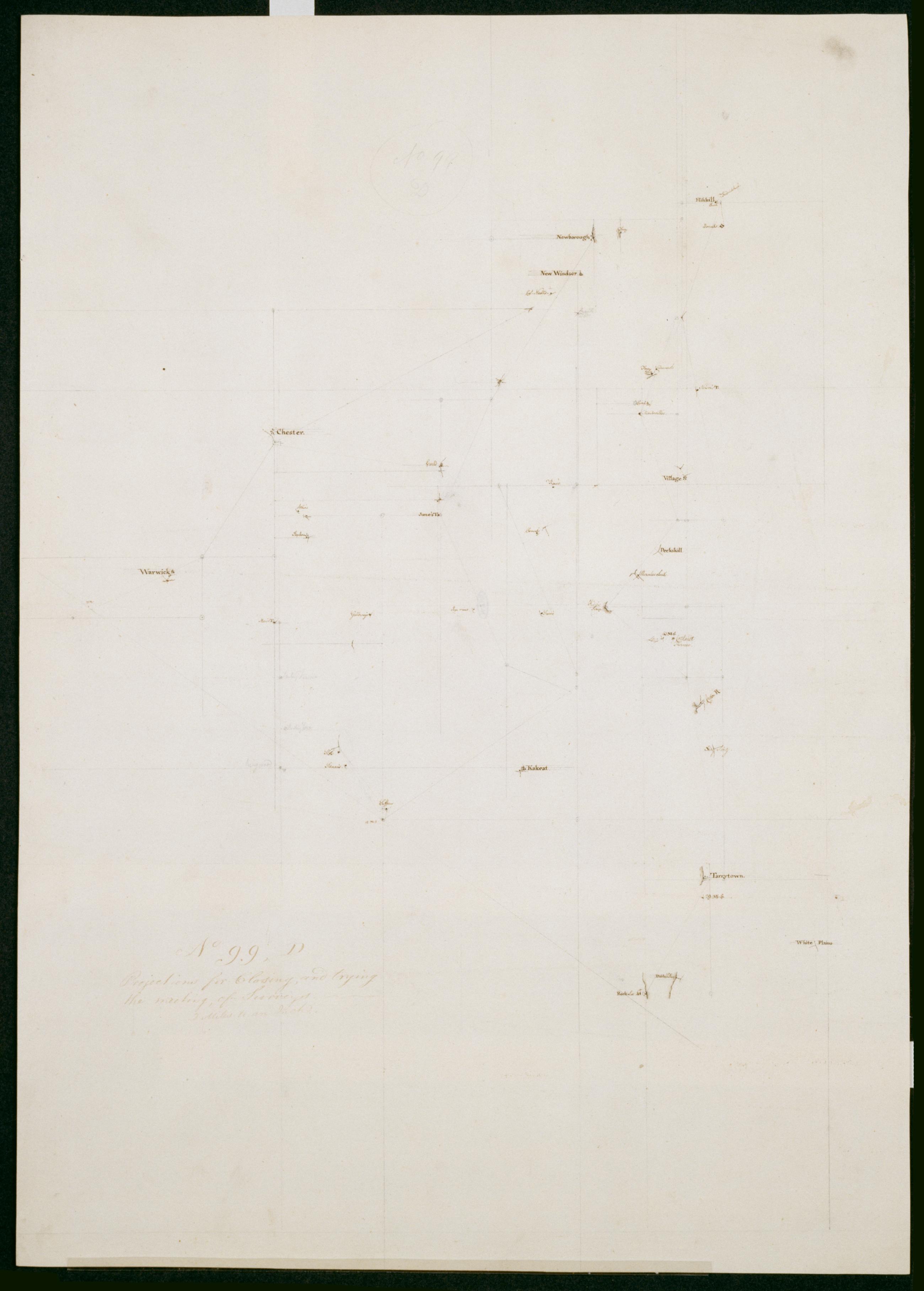
Cartographic Projections for Closing and trying the meeting of Surveys. No 99 D / Large paper by Capt. Scull ; by Robert Erskine F.R.S. Geogr. A. U.S. and Assistants. In ink on verso: "No. 99 D". In pencil on recto: "No 99 D". Military topographic map; an early draft. Covers Dutchess- Orange- Putnam- Rockland and Westchester counties in New York. Pen-and-ink- pencil on laid paper. Soiled- creased and abraded. Mounted on cloth- bound and cropped- disbound and silked by subsequent owners. Cleaned after removal of backings 1999; some fill remains. Sheathed in mylar. Title proper from recto is the work of a later editor--Simeon DeWitt or his assign--subsequent to 1820. View Item
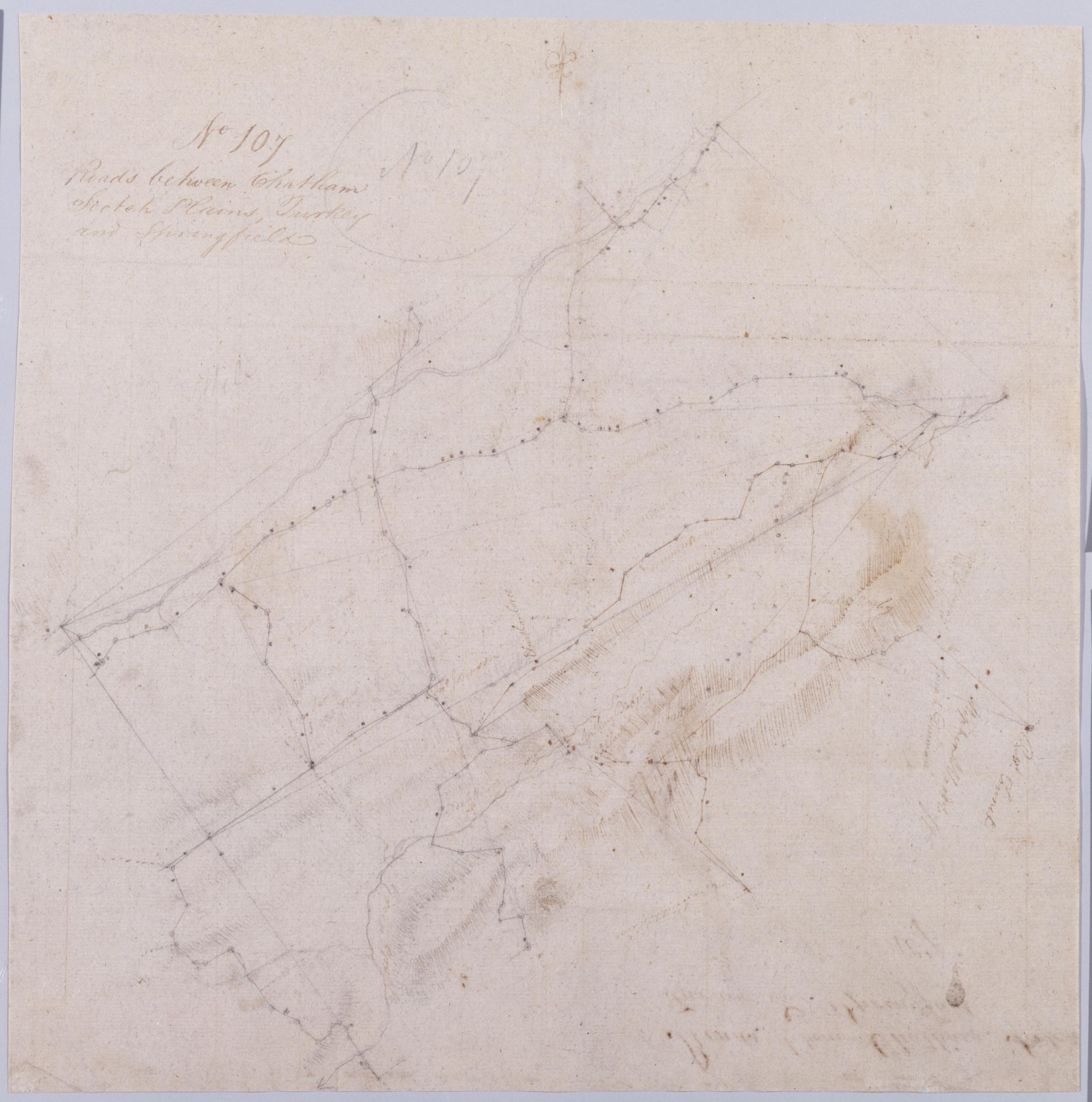
Cartographic Roads between Chatham Scotch Plains Turkey and Springfield. No 107 / by Robert Erskine F.R.S. Geogr. A. U.S. and Assistants. In pencil on recto: "No 107". Military topographic map. Covers the townships of Summit- Springfield- Providence- Westfield- Fanwood and North Plainfield in Union County- New Jersey. Shows buildings and owners' names- landforms and streams. Pen-and-ink- pencil on laid paper. Title proper from recto is the work of a later editor--Simeon DeWitt or his assign--subsequent to 1820. Title from verso is in Erskine's hand and may be cited as such. Index title- statement of responsibility- date- series title and series numbering also by Erskine- but on separate index sheet filed at head of series. View Item
Cartographic Spherical Projections. No 100 / by R.E. ; by Robert Erskine F.R.S. Geogr. A. U.S. and Assistants first sheet Collection of unfinished military topographic maps. The coordinates describe much of New Jersey but- aside from the coordinate grid itself- only small areas about Elizabethtown and Amboy- New Jersey- and about Warwick and Chester- New York- were ever mapped onto it. Title proper from recto of 1st sheet is the work of a later editor--Simeon DeWitt or his assign--subsequent to 1820. Index title- both statements of responsibility- date- scale statement- series title and series numbering by Erskine- but on separate index sheet filed at head of series. Pen-and-ink- pencil on laid paper. View Item
Cartographic Roads from Newborough to Fort Lee. No 36 / by Robert Erskine F.R.S. Geogr. A. U.S. and Assistants. Military topographic map. Covers Orange and Rockland Counties in New York and Bergen- Passaic- Morris and Essex Counties in New Jersey. Shows roads- buildings and owners' names- also landforms- wetlands and streams. Shows relief by hachures. Title proper from recto is the work of a later editor--Simeon DeWitt or his assign--subsequent to 1820. Index title- statement of responsibility- date- series title and series numbering also by Erskine- but on separate index sheet filed at head of series. Pen-and-ink- pencil on laid paper. View Item
Cartographic From Sawpitts to Stanwich Stamford Bedford & Pine's Bridge on Croton River. No. 24 / by Robert Erskine F.R.S. Geogr. A. U.S. and Assistants. Military topographic map. Covers the towns of Yorktown- Newcastle- Bedford- North Castle and Pound Ridge in eastern Westchester County- New York- and the towns of Stamford and Greenwich in Fairfield County- Connecticut. The map itself gives Stamford as "Stanford" and the Mill or Rippowam River as the "Stanford River." It shows roads- buildings and owners' names- also landforms and streams. Maps shows relief by hachures. Titles proper from recto and recto of inset are the work of a later editor--Simeon DeWitt or his assign--subsequent to 1820. View Item
Cartographic Roads from Peekskill to Pines Bridge on Croton River +c. No 32 / by Robert Erskine F.R.S. Geogr. A. U.S. and Assistants. Also in ink on verso- a crossed-out text of which 500 words are extant; incipit "plane of which the representation is to be drawn- and the place of the Eyes. [Paragraph] The General principle [on which--crossed out] of Perspective [is the--crossed out] supposes pencils of rays...." Ancillary geometric drawings in ink and pencil on recto and verso. In pencil on recto: "No 32". Military topographic map. Covers the towns of Cortlandt- Ossining- Mt. Pleasant- Yorktown and Newcastle in Westchester County- New York. View Item
Cartographic Roads between Suffrans Tappan Kakeate Peramus Dobbs Ferry Clarkstown +c. No 113 1st / by Robert Erskine F.R.S. Geogr. A. U.S. and Assistants. Military topographic map. Covers the townships of Orangetown- Ramapo and Clarkstown in Rockland County- New York- and of Herrington- Washington- Palisades- Midland- Ridgewood and Orvil in Bergen County- New Jersey. Shows buildings and owners' names- landforms and streams. Shows relief by hachures. Title proper from recto is the work of a later editor--Simeon DeWitt or his assign--subsequent to 1820. Title from verso is in Erskine's hand and may be cited as such. View Item
Cartographic A General Contraction 2 Miles to an Inch. No 37 / by R.E. ; by Robert Erskine F.R.S. Geogr. A. U.S. and Assistants. Military topographic map. Covers the lower Hudson River Valley in New York- New Jersey and Connecticut- from Warwick (N.Y.) and Pompton Plains (N.J.) to New Milford and Danbury (Conn.)- and from Newburgh (N.Y.) to Staten Island (N.Y.). Shows roads- buildings and owners' names- also landforms and streams. Shows relief by hachures. Title proper from recto is the work of a later editor--Simeon DeWitt or his assign--subsequent to 1820. Index title- both statements of responsibility- date- series title and series numbering by Erskine- but on separate index sheet filed at head of series. View Item
Cartographic A Plan of the River Schuylkill Wherein are laid down the several Shoals with the depth of Water on each in Inches also the Depth of the Channel in general in the beginning of August 1773 Together with the means proposed for improving the Navigation of s Foxed- soiled- stained and creased. Mounted on cloth and cropped. In pencil on recto: "No 89". Includes index to 66 numbered features. Military topographic map. Covers the counties of Berks- Chester- Montgomery and Philadelphia- Pennsylvania- between Reading and Philadelphia. Shows river features and depths by soundings. Does not show landward features. Pen-and-ink- pencil on laid paper. Title proper and first statement of responsibility from map recto. Title number supplied by cataloger. View Item
Cartographic Road from Newborough to Peeks kill. No. 6. & 7 (both sides) ; Road from Newborrough to Peeks kill. No. 6 & 7 (both sides) / by Robert Erskine F.R.S. Geogr. A. U.S. and Assistants. Frayed- creased- foxed and abraded. Mounted on cloth- bound and cropped- disbound- silked by later owners. Cleaned after removal of backings 1999. Sheathed in mylar. In ink on recto- but in reverse writing: "Jacob DeWitt" (printed)- "Jacob DeWitt" (signature). In ink on recto: "No. 6 - No. 7". In ink on verso: "No. 6 + 7". Maps show relief by hachures. Military topographic maps. Maps cover the towns of Fishkill and Phillipstown in Putnam County and of Peekskill in Westchester County- New York. View Item
Cartographic From Albany to Scoharie. No 52 1st Part [sic] / by Robert Erskine F.R.S. Geogr. A. U.S. and Assistants ; by Capt. Gray. Military topographic map. Covers the counties of Albany- Schenectady and Scoharie- New York. Shows roads running through Albany- Westmere- Guilderland- Hartmans Corners- Guilderland Center- Altamont- Knox- Gallupville- Shutter Corners and- just north of Schoharie- Vrooman Corners; also Quaker Street- Duanesburg- Princeton or Kelley Station- Rotterdam- Schnectady- Hawthorne Hill- Niskayuna- Freligh- Crescent Station to near Crescent- Cohoes and Watervliet. Map also shows buildings and owners' names- landforms and streams. Shows relief by hachures. View Item
Cartographic Road from Suffrans to June's King's Ferry Fort Montgomery +c. No 1 A ; Road from Peekskill to Teller's Point Tarrytown +c. No 1 B / by Robert Erskine F.R.S. Geogr. A. U.S. and Assistants. Military topographic maps. Map 1A on recto covers the towns of Woodbury and Tuxedo in Orange County- and of Highland- Stoney Point- Haverstraw and Ramapo in Rockland County- New York; it shows roads running through Fort Montgomery- West Haverstraw- Hempstead- Viola- Suffern- Ramapo- Sloatsburg- Tuxedo- Southfield- Arden- Willow Grove and Thiells. Map 1B on verso covers the towns of Cortlandt- Newcastle- Ossining and Mt. View Item
Cartographic R. from 15 M. stone near Suffran's to Ft Lee Hackensack Closter Tappan Clarkstown Haverstraw +c. No 26 / by J. Watkins Esqr ; surveys made by Capt: John W: Watkins A:B: ; by Robert Erskine F.R.S. Geogr. A. U.S. and Assistants. Military topographic map. Covers most of Rockland County- New York- and Bergen County- New Jersey. Shows roads running through Suffern- Saddle River- Paramus and Hackensack- as well as Haverstraw- Clarksville- Tappan- Tenefly and Closter. Also shows buildings and owners' names- landforms- ground cover- wetlands and streams. Shows relief by hachures. Title proper and first statement of responsibility from recto are the work of a later editor--Simeon DeWitt or his assign--subsequent to 1820. Second statement of responsibility and detailed date also from apparently written by Watkins. View Item
Image Collection 7 Items Richard Varick papers, 1743-1871 (bulk 1775-1830) Richard Varick, born in New Jersey, 1753, served as Captain, deputy muster-master-general, and George Washington's secretary during the Revolutionary war. He was appointed one of the first mayors of New York and served from 1789-1801. He died in 1831. His papers pertain to a variety of subjects, including Varick's command of a company in Alexander McDougall's battalion at Ticonderoga and in Canada during 1775; his service on courts-martial in 1775; problems of the bateau service in northern New York State in 1776; his position as secretary to Gen. View Collection
Image Collection 288 Items Robert Erskine-Simeon DeWitt maps, 1778-1783 This series of field sketches and finished maps of projected battle sites in New York, New Jersey, Connecticut and Pennsylvania during the Revolutionary war was begun by Robert Erskine, geographer and surveyor-general to the Continental Army, and completed by his successor, Simeon De Witt. Robert Erskine (1735-1780) was appointed Geographer to Washington's army in 1777. He surveyed both sides of the Hudson River and a large area covering the adjoining states. Many of the maps are rough field sketches, from which more detailed maps were later drawn. View Collection