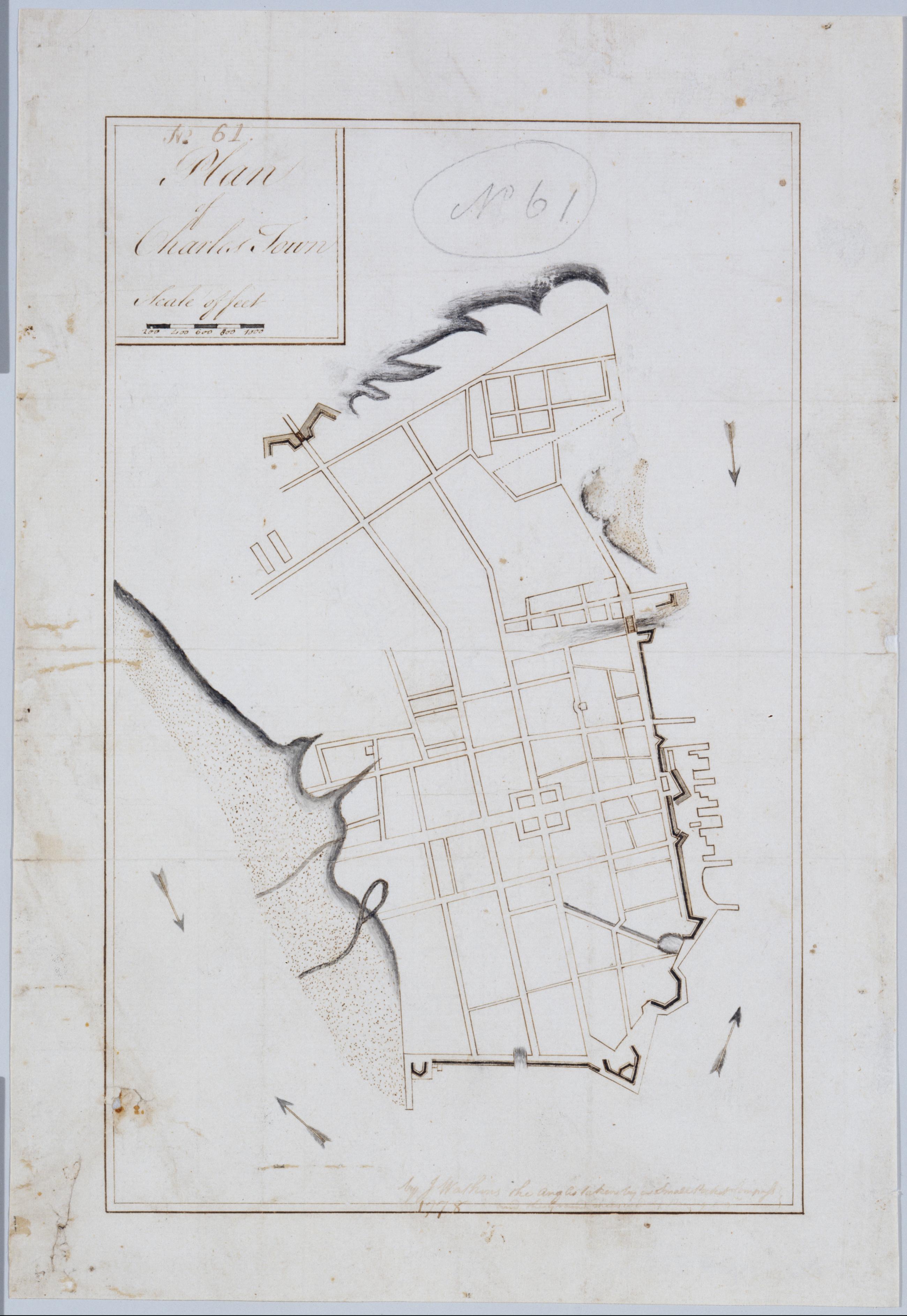
Cartographic Plan of Charles Town. No. 61 / by J. Watkins ; by J. Watkin ; by Robert Erskine F.R.S. Geogr. A. U.S. and Assistants. In ink on verso: "No. 61". Military topographic map. Shows streets, piers, streams and wetlands. Pen-and-ink, grey wash on laid paper. Stained, foxed, creased, frayed and abraded. Mounted on cloth, bound and cropped, disbound and silked by subsequent owners. Cleaned after removal of backings 1999; some fill remains. Sheathed in mylar. Title proper from original cartouche; number appears to have been added later. View Item
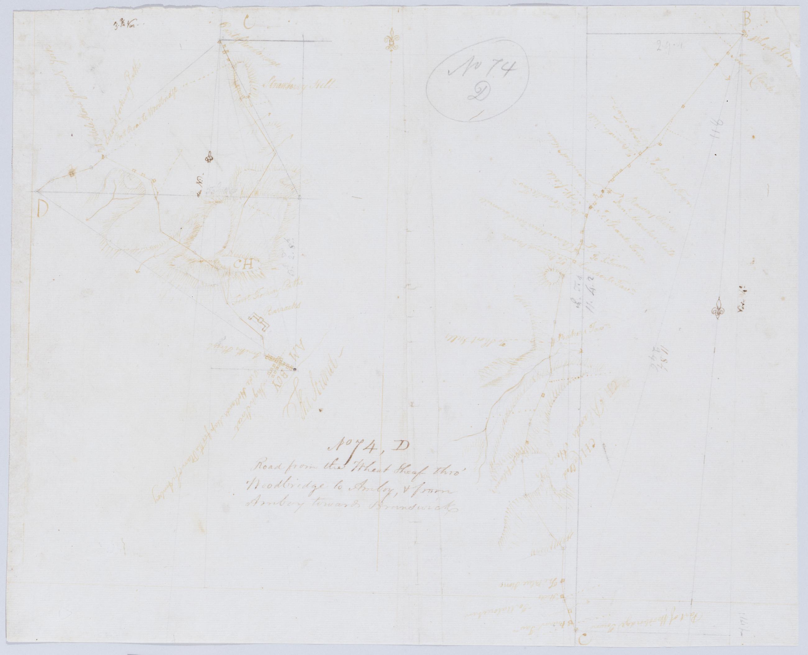
Cartographic Road from the Wheat Sheaf thro' Woodbridge to Amboy, + from Amboy towards Brunswick. No 74, D / by Robert Erskine F.R.S. Geogr. A. U.S. and Assistants. Foxed, creased, frayed and abraded. Mounted on cloth, bound and cropped, disbound and silked by subsequent owners. Cleaned after removal of backings 1999; some fill remains. Sheathed in mylar. In pencil on recto: "No 74 D". Military topographic map; righthand segment fits north of the lefthand one. Map covers the townships of Rahway and Linden in Union County and of Woodbridge in Middlesex County, New Jersey. Shows roads running through Wheatsheaf, Rahway, Demorest, Woodbridge, Spa Spring, Amboy, Fairfield Union and Valentine Fords. View Item
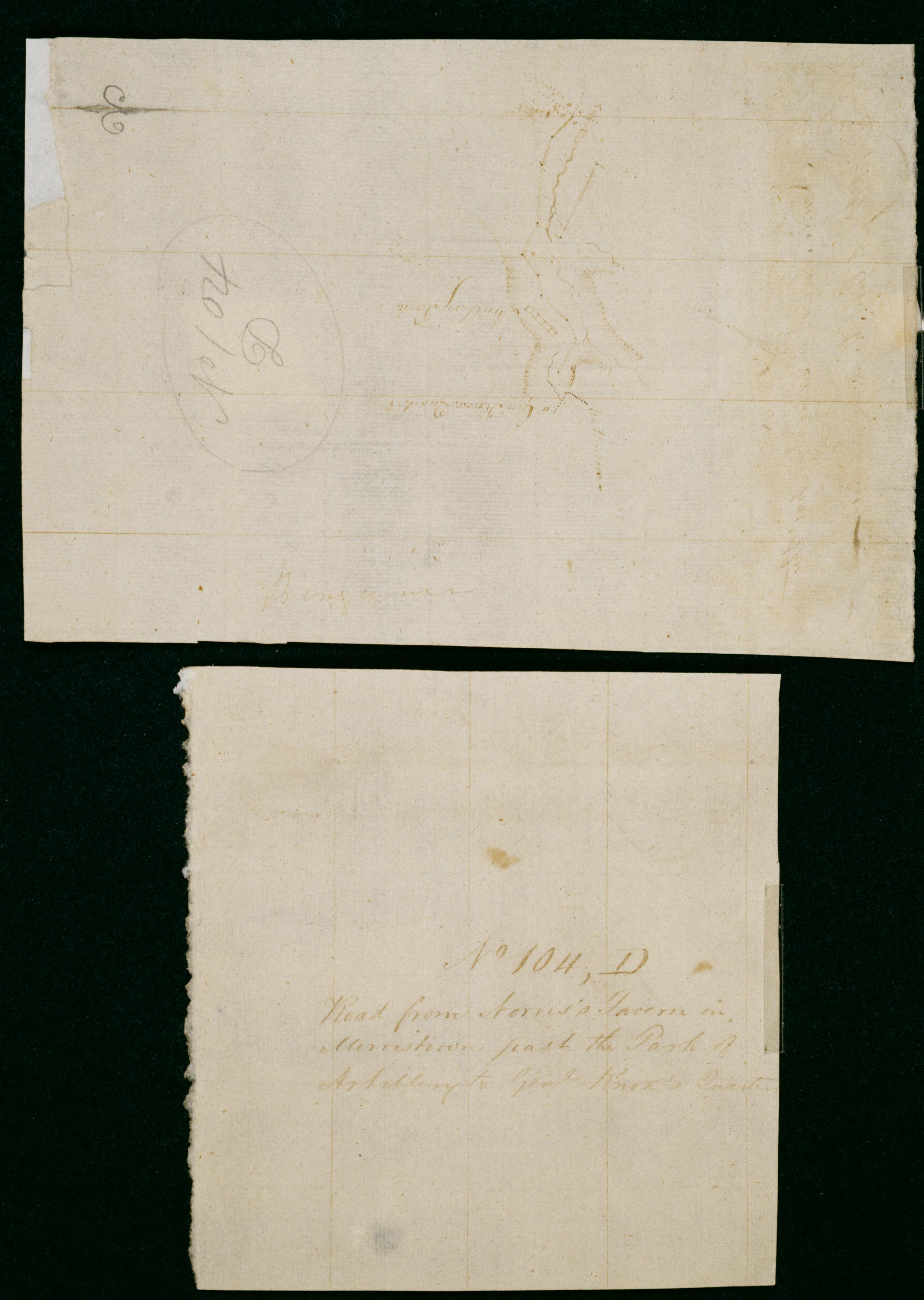
Cartographic Road from Norris's Tavern in Morristown past the Park of Artillery to Genl Knoxs Quarters. No 104, D / by Robert Erskine F.R.S. Geogr. A. U.S. and Assistants. Military topographic map. Covers part of Morristown in Morris County, New Jersey. Shows buildings and owners' names, landforms and streams. Shows relief by hachures. Title proper from recto is the work of a later editor--Simeon DeWitt or his assign--subsequent to 1820. Title from verso is in Erskine's hand and may be cited as such; it has been damaged by cropping. Index title, statement of responsibility, date, series title and series numbering also by Erskine, but on separate index sheet filed at head of series. Pen-and-ink, pencil on laid paper. Watermark: none. View Item
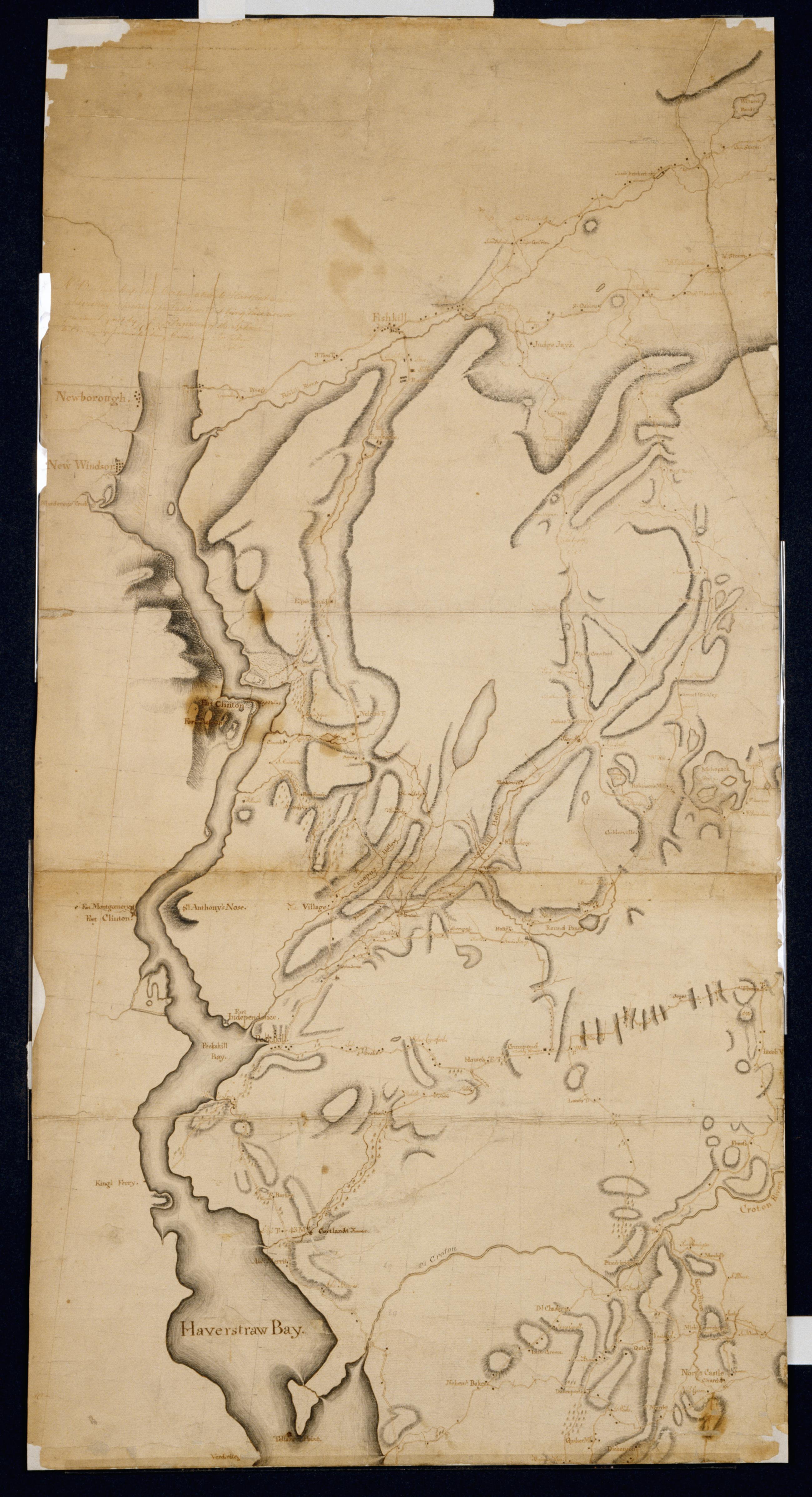
Cartographic Projections for Closing, and trying the meeting of Surveys. No 99, D / Large paper by Capt. Scull ; by Robert Erskine F.R.S. Geogr. A. U.S. and Assistants. In ink on verso: "No. 99 D". In pencil on recto: "No 99 D". Military topographic map; an early draft. Covers Dutchess, Orange, Putnam, Rockland and Westchester counties in New York. Pen-and-ink, pencil on laid paper. Soiled, creased and abraded. Mounted on cloth, bound and cropped, disbound and silked by subsequent owners. Cleaned after removal of backings 1999; some fill remains. Sheathed in mylar. Title proper from recto is the work of a later editor--Simeon DeWitt or his assign--subsequent to 1820. View Item
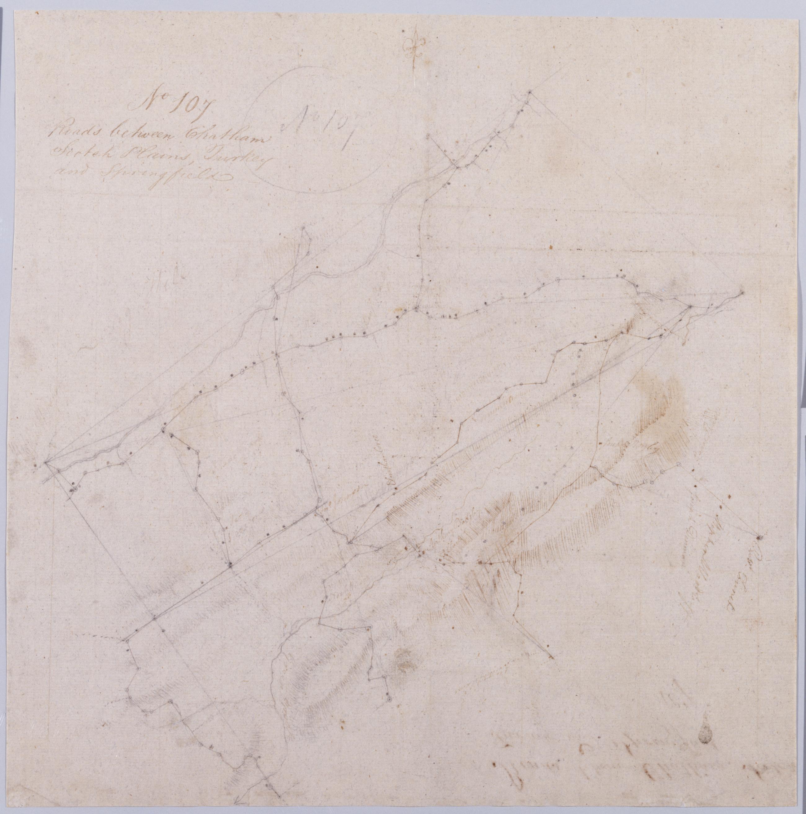
Cartographic Roads between Chatham Scotch Plains, Turkey and Springfield. No 107 / by Robert Erskine F.R.S. Geogr. A. U.S. and Assistants. In pencil on recto: "No 107". Military topographic map. Covers the townships of Summit, Springfield, Providence, Westfield, Fanwood and North Plainfield in Union County, New Jersey. Shows buildings and owners' names, landforms and streams. Pen-and-ink, pencil on laid paper. Title proper from recto is the work of a later editor--Simeon DeWitt or his assign--subsequent to 1820. Title from verso is in Erskine's hand and may be cited as such. Index title, statement of responsibility, date, series title and series numbering also by Erskine, but on separate index sheet filed at head of series. View Item
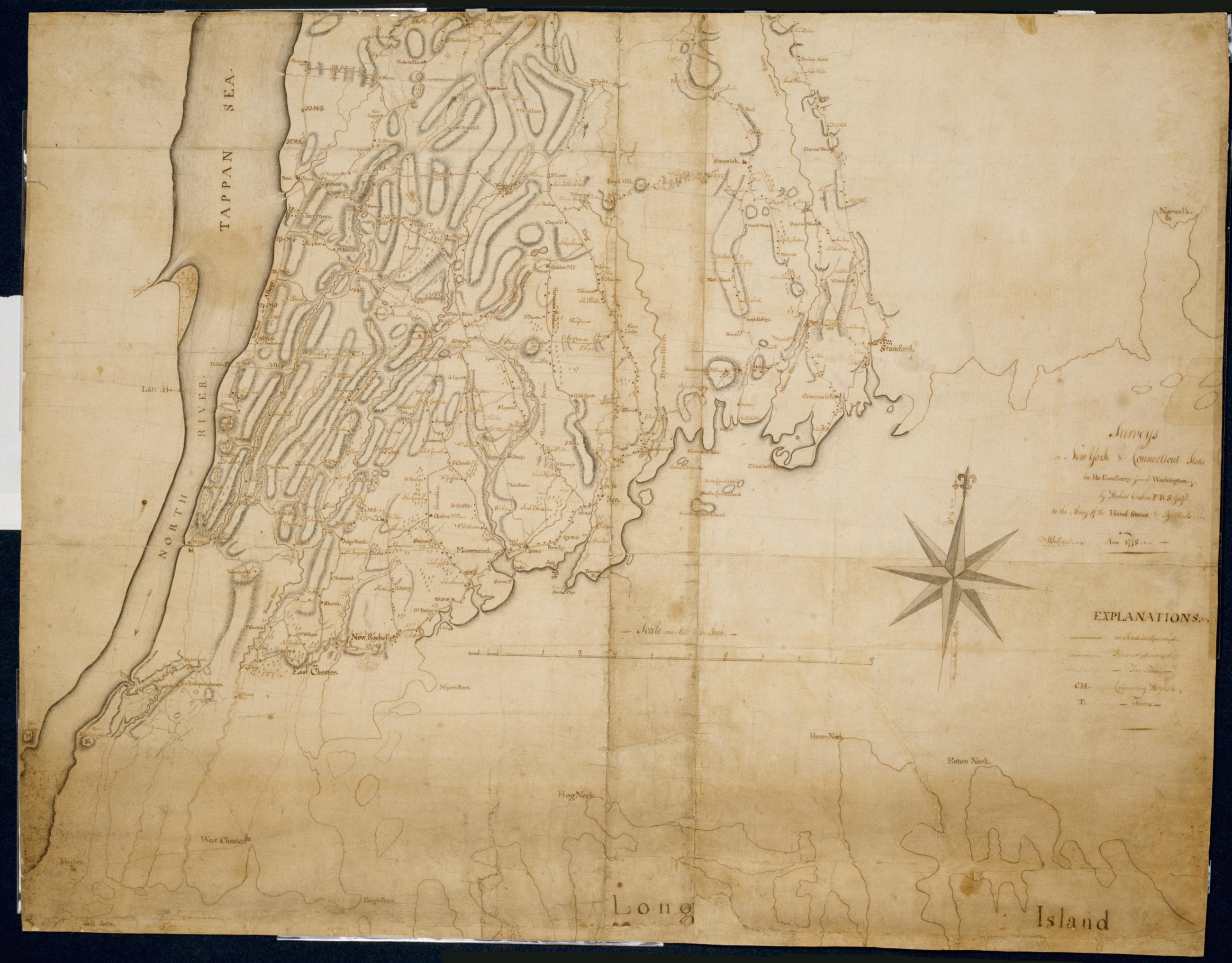
Cartographic Surveys in New York & Connecticut States for His Excellency General Washington : Anno 1778 by Robert Erskine F.R.S. Geogr: to the Army of the United States & Assistants ; W Scull delint., first fragment Has projection grid in faint pencil. Imperfect: lacks 19 x 12 at upper right corner and 3 x 8 cm. at center. Minor losses along frayed top and left edge. Military topographic map; not listed in Heusser nor Guthorn. Covers the counties of Fairfield in Connecticut and of Dutchess, Putnam and Westchester in New York; New York City and the northern shore of Long Island are also shown, but with less detail. Shows some buildings and owners' names, landforms and streams. Pen-and-ink, pencil on laid paper. View Item
Cartographic Surveys in New York & Connecticut States for His Excellency General Washington : Anno 1778 by Robert Erskine F.R.S. Geogr: to the Army of the United States & Assistants ; W Scull delint., third fragment Has projection grid in faint pencil. Imperfect: lacks 19 x 12 at upper right corner and 3 x 8 cm. at center. Minor losses along frayed top and left edge. Military topographic map; not listed in Heusser nor Guthorn. Covers the counties of Fairfield in Connecticut and of Dutchess, Putnam and Westchester in New York; New York City and the northern shore of Long Island are also shown, but with less detail. Shows some buildings and owners' names, landforms and streams. Pen-and-ink, pencil on laid paper. View Item
Cartographic Surveys in New York & Connecticut States for His Excellency General Washington : Anno 1778 by Robert Erskine F.R.S. Geogr: to the Army of the United States & Assistants ; W Scull delint., second fragment Has projection grid in faint pencil. Imperfect: lacks 19 x 12 at upper right corner and 3 x 8 cm. at center. Minor losses along frayed top and left edge. Military topographic map; not listed in Heusser nor Guthorn. Covers the counties of Fairfield in Connecticut and of Dutchess, Putnam and Westchester in New York; New York City and the northern shore of Long Island are also shown, but with less detail. Shows some buildings and owners' names, landforms and streams. Pen-and-ink, pencil on laid paper. View Item
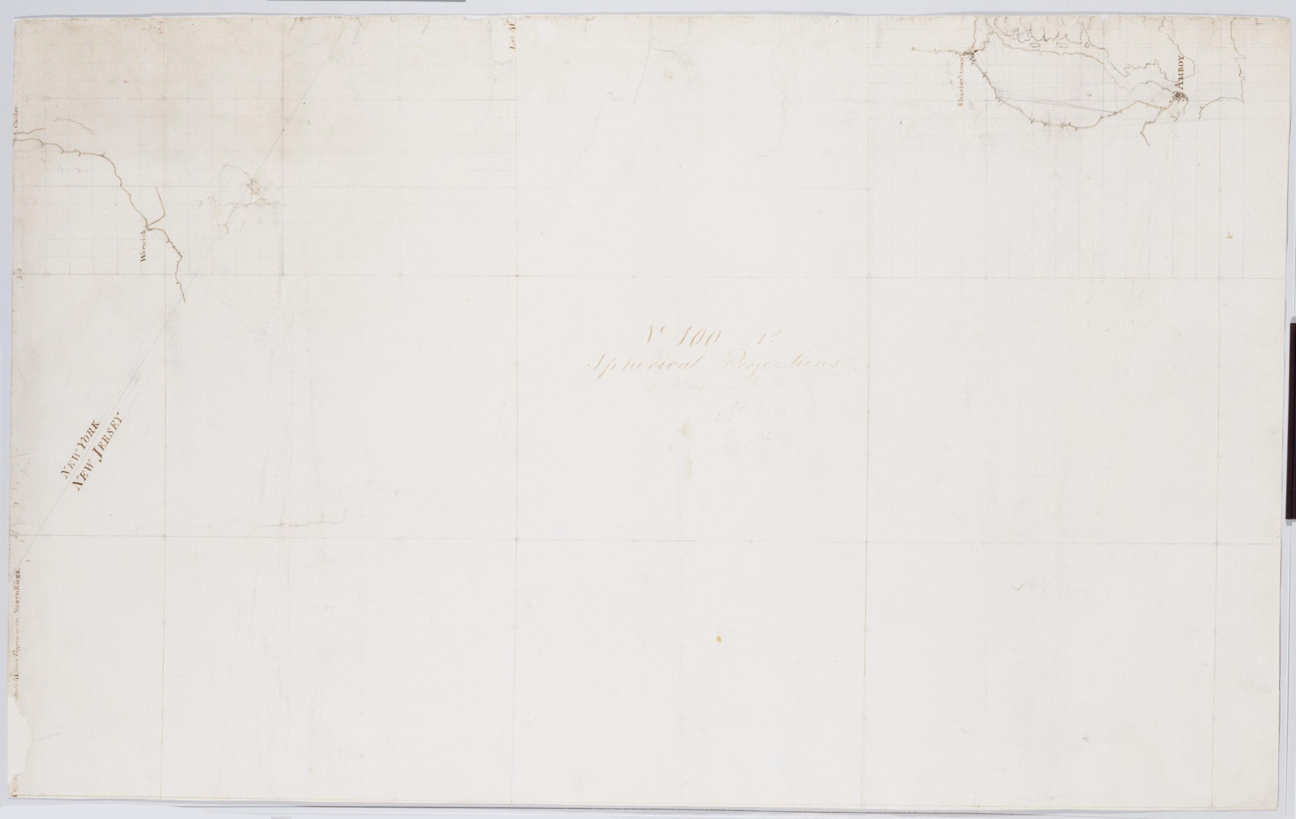
Cartographic Spherical Projections. No 100 / by R.E. ; by Robert Erskine F.R.S. Geogr. A. U.S. and Assistants, second sheet Collection of unfinished military topographic maps. The coordinates describe much of New Jersey but, aside from the coordinate grid itself, only small areas about Elizabethtown and Amboy, New Jersey, and about Warwick and Chester, New York, were ever mapped onto it. Title proper from recto of 1st sheet is the work of a later editor--Simeon DeWitt or his assign--subsequent to 1820. Index title, both statements of responsibility, date, scale statement, series title and series numbering by Erskine, but on separate index sheet filed at head of series. Pen-and-ink, pencil on laid paper. View Item
Cartographic Spherical Projections. No 100 / by R.E. ; by Robert Erskine F.R.S. Geogr. A. U.S. and Assistants, first sheet Collection of unfinished military topographic maps. The coordinates describe much of New Jersey but, aside from the coordinate grid itself, only small areas about Elizabethtown and Amboy, New Jersey, and about Warwick and Chester, New York, were ever mapped onto it. Title proper from recto of 1st sheet is the work of a later editor--Simeon DeWitt or his assign--subsequent to 1820. Index title, both statements of responsibility, date, scale statement, series title and series numbering by Erskine, but on separate index sheet filed at head of series. Pen-and-ink, pencil on laid paper. View Item
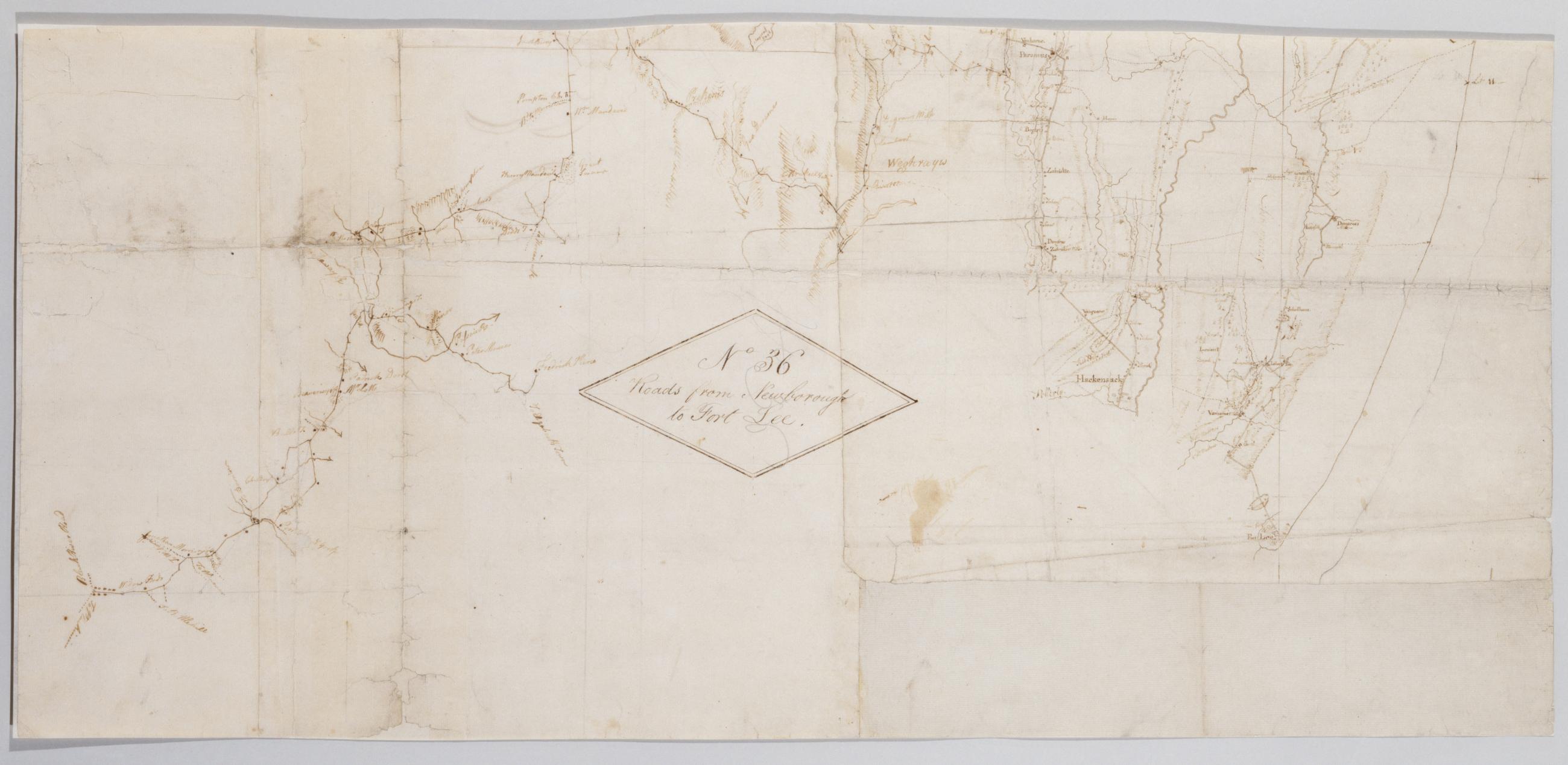
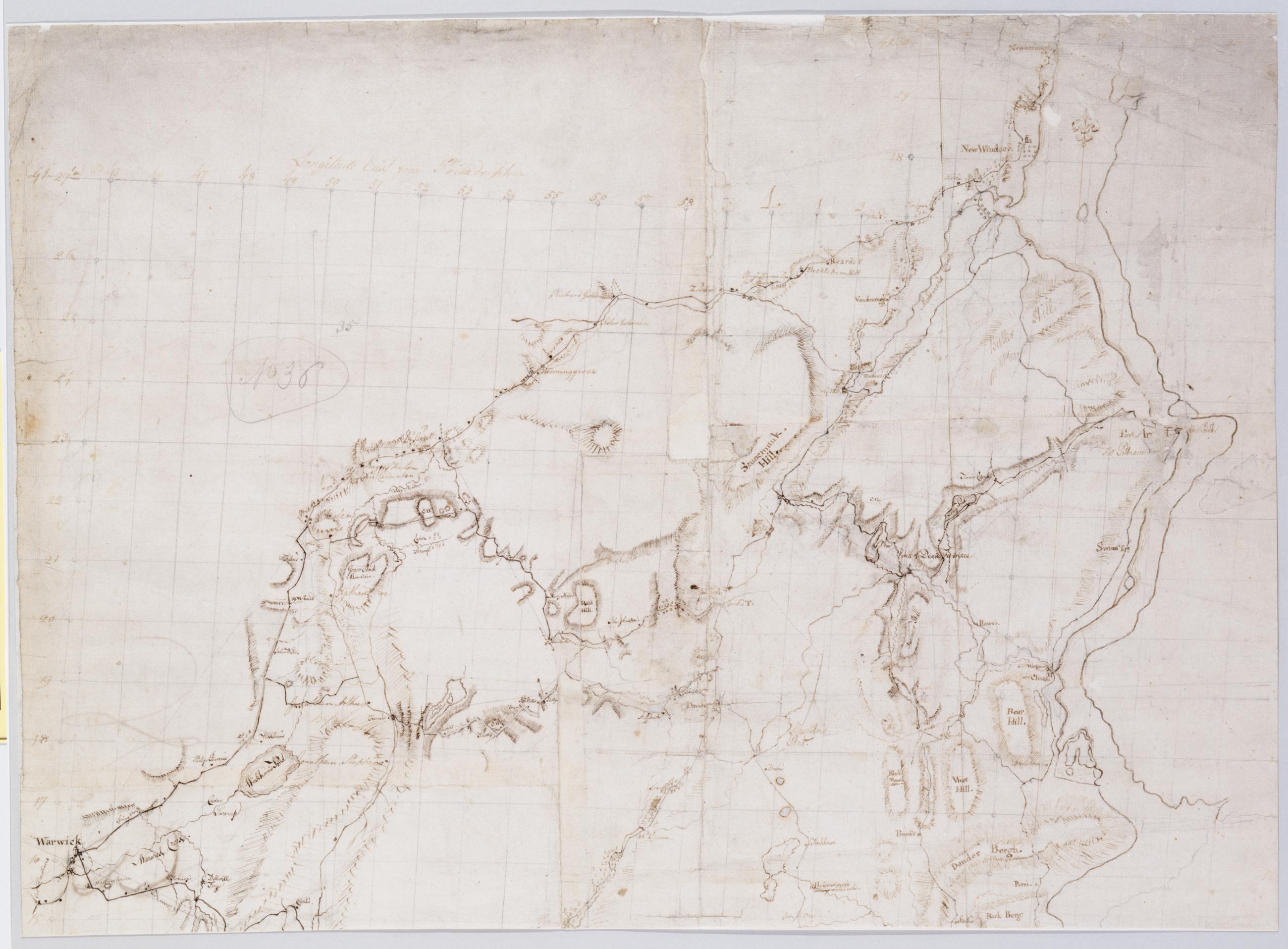
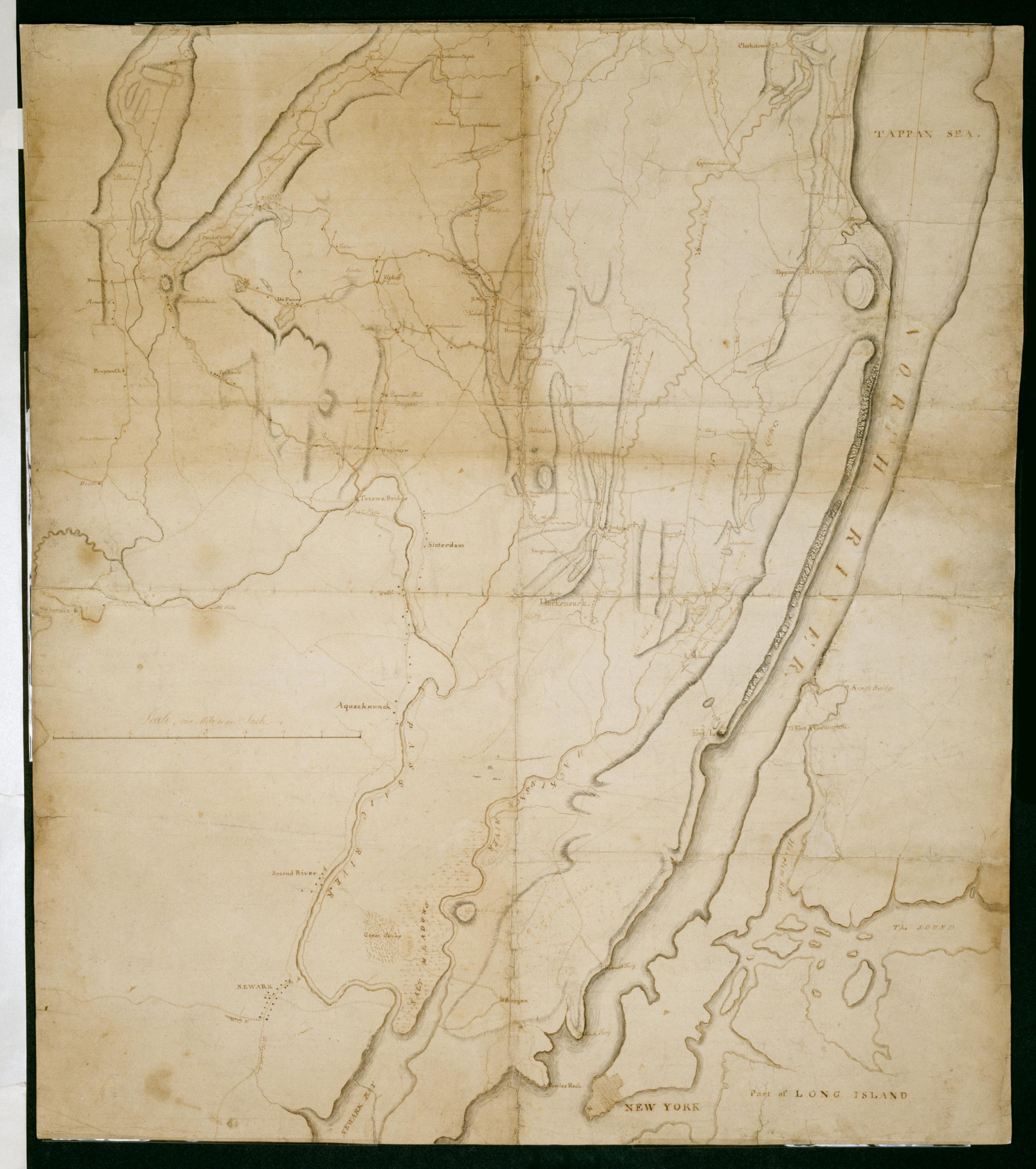
Cartographic Roads from Newborough to Fort Lee. No 36 / by Robert Erskine F.R.S. Geogr. A. U.S. and Assistants, bottom Military topographic map. Covers Orange and Rockland Counties in New York and Bergen, Passaic, Morris and Essex Counties in New Jersey. Shows roads, buildings and owners' names, also landforms, wetlands and streams. Shows relief by hachures. Title proper from recto is the work of a later editor--Simeon DeWitt or his assign--subsequent to 1820. Index title, statement of responsibility, date, series title and series numbering also by Erskine, but on separate index sheet filed at head of series. Pen-and-ink, pencil on laid paper. View Item
Cartographic Roads from Newborough to Fort Lee. No 36 / by Robert Erskine F.R.S. Geogr. A. U.S. and Assistants, top Military topographic map. Covers Orange and Rockland Counties in New York and Bergen, Passaic, Morris and Essex Counties in New Jersey. Shows roads, buildings and owners' names, also landforms, wetlands and streams. Shows relief by hachures. Title proper from recto is the work of a later editor--Simeon DeWitt or his assign--subsequent to 1820. Index title, statement of responsibility, date, series title and series numbering also by Erskine, but on separate index sheet filed at head of series. Pen-and-ink, pencil on laid paper. View Item
Cartographic Roads from Newborough to Fort Lee. No 36 / by Robert Erskine F.R.S. Geogr. A. U.S. and Assistants, center Military topographic map. Covers Orange and Rockland Counties in New York and Bergen, Passaic, Morris and Essex Counties in New Jersey. Shows roads, buildings and owners' names, also landforms, wetlands and streams. Shows relief by hachures. Title proper from recto is the work of a later editor--Simeon DeWitt or his assign--subsequent to 1820. Index title, statement of responsibility, date, series title and series numbering also by Erskine, but on separate index sheet filed at head of series. Pen-and-ink, pencil on laid paper. View Item
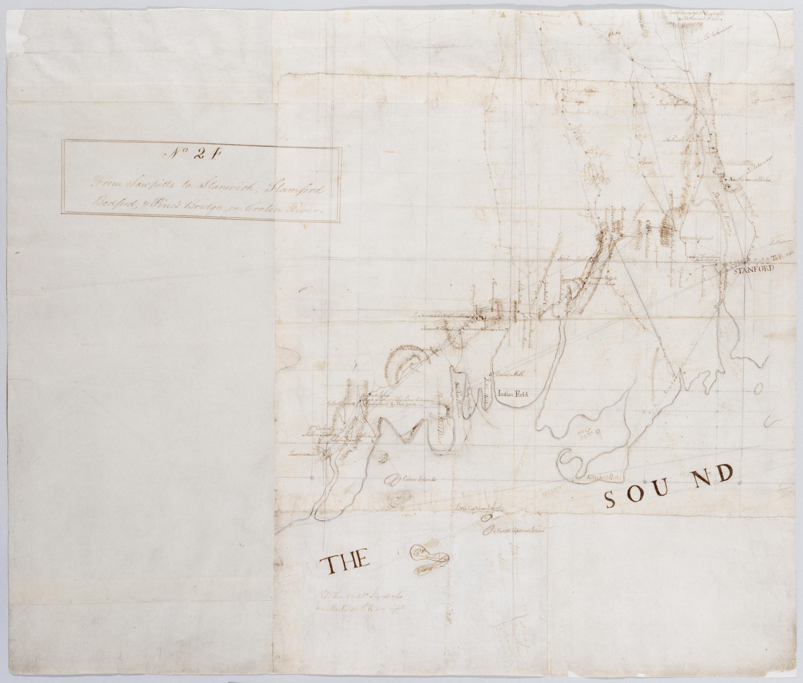
Cartographic From Sawpitts to Stanwich, Stamford Bedford, & Pine's Bridge on Croton River. No. 24 / by Robert Erskine F.R.S. Geogr. A. U.S. and Assistants, inset. Military topographic map. Covers the towns of Yorktown, Newcastle, Bedford, North Castle and Pound Ridge in eastern Westchester County, New York, and the towns of Stamford and Greenwich in Fairfield County, Connecticut. The map itself gives Stamford as "Stanford" and the Mill or Rippowam River as the "Stanford River." It shows roads, buildings and owners' names, also landforms and streams. Maps shows relief by hachures. Titles proper from recto and recto of inset are the work of a later editor--Simeon DeWitt or his assign--subsequent to 1820. View Item
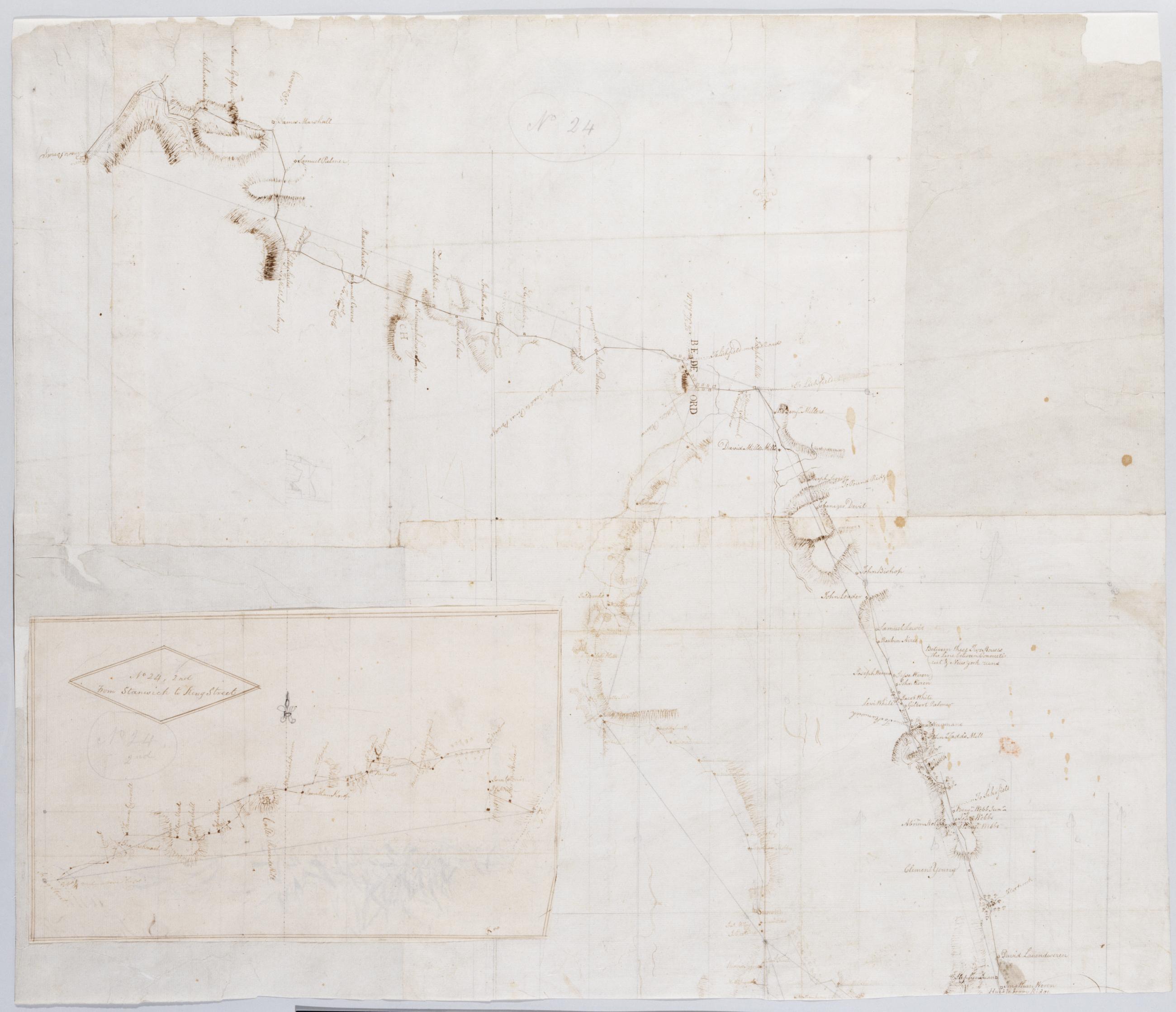
Cartographic From Sawpitts to Stanwich, Stamford Bedford, & Pine's Bridge on Croton River. No. 24 / by Robert Erskine F.R.S. Geogr. A. U.S. and Assistants. Military topographic map. Covers the towns of Yorktown, Newcastle, Bedford, North Castle and Pound Ridge in eastern Westchester County, New York, and the towns of Stamford and Greenwich in Fairfield County, Connecticut. The map itself gives Stamford as "Stanford" and the Mill or Rippowam River as the "Stanford River." It shows roads, buildings and owners' names, also landforms and streams. Maps shows relief by hachures. Titles proper from recto and recto of inset are the work of a later editor--Simeon DeWitt or his assign--subsequent to 1820. View Item
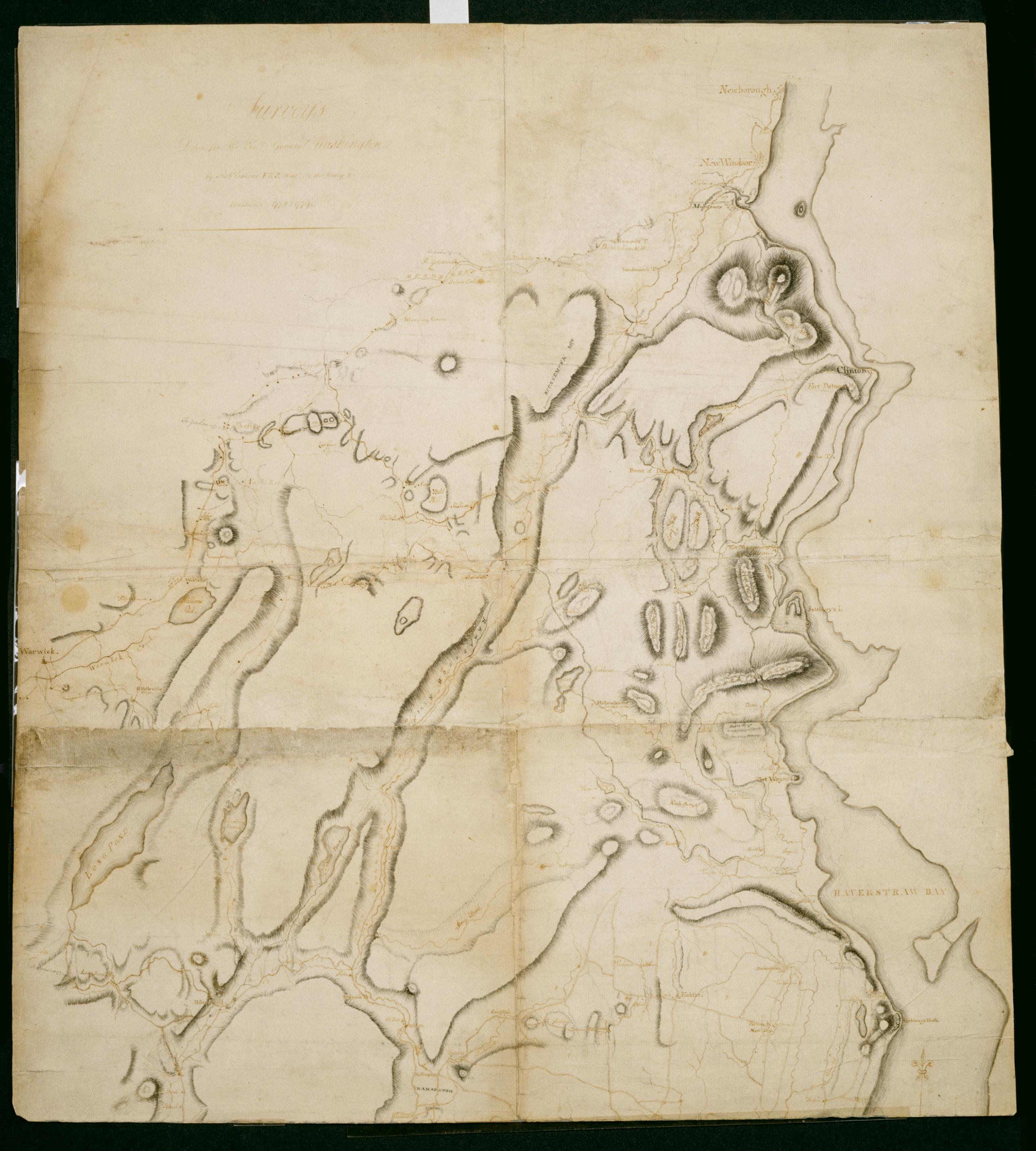
Cartographic Surveys Done for His Excy General Washington : 1778 & 1779 / by Robt Erskine F.R.S. Geogr to the Army & Assistants, second sheet Verso title: Map of North River made by Robt Erskine 1778 & 9. Second verso title: Map of part of the State of New York. Military topographic map; not listed in Heusser nor Guthorn. Covers the counties of Orange and Rockland in New York and of Passaic, Bergen, Hudson and Essex in New Jersey. Shows some roads; map appears to be incomplete in this respect as of date given. Also shows some buildings and owners' names, landforms and streams. Shows relief by hachures. Title proper and statement of responsibility from recto is original. Titles on verso are later. View Item
Cartographic Surveys Done for His Excy General Washington : 1778 & 1779 / by Robt Erskine F.R.S. Geogr to the Army & Assistants, first sheet Verso title: Map of North River made by Robt Erskine 1778 & 9. Second verso title: Map of part of the State of New York. Military topographic map; not listed in Heusser nor Guthorn. Covers the counties of Orange and Rockland in New York and of Passaic, Bergen, Hudson and Essex in New Jersey. Shows some roads; map appears to be incomplete in this respect as of date given. Also shows some buildings and owners' names, landforms and streams. Shows relief by hachures. Title proper and statement of responsibility from recto is original. Titles on verso are later. View Item
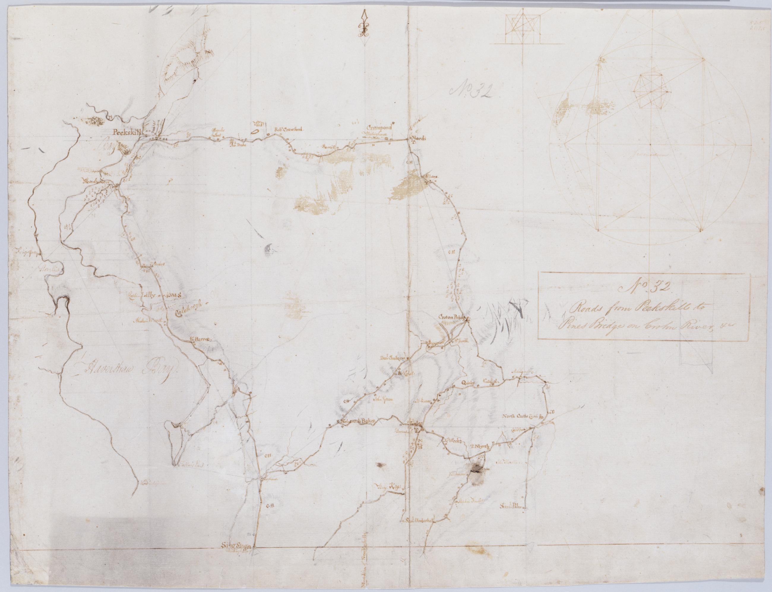
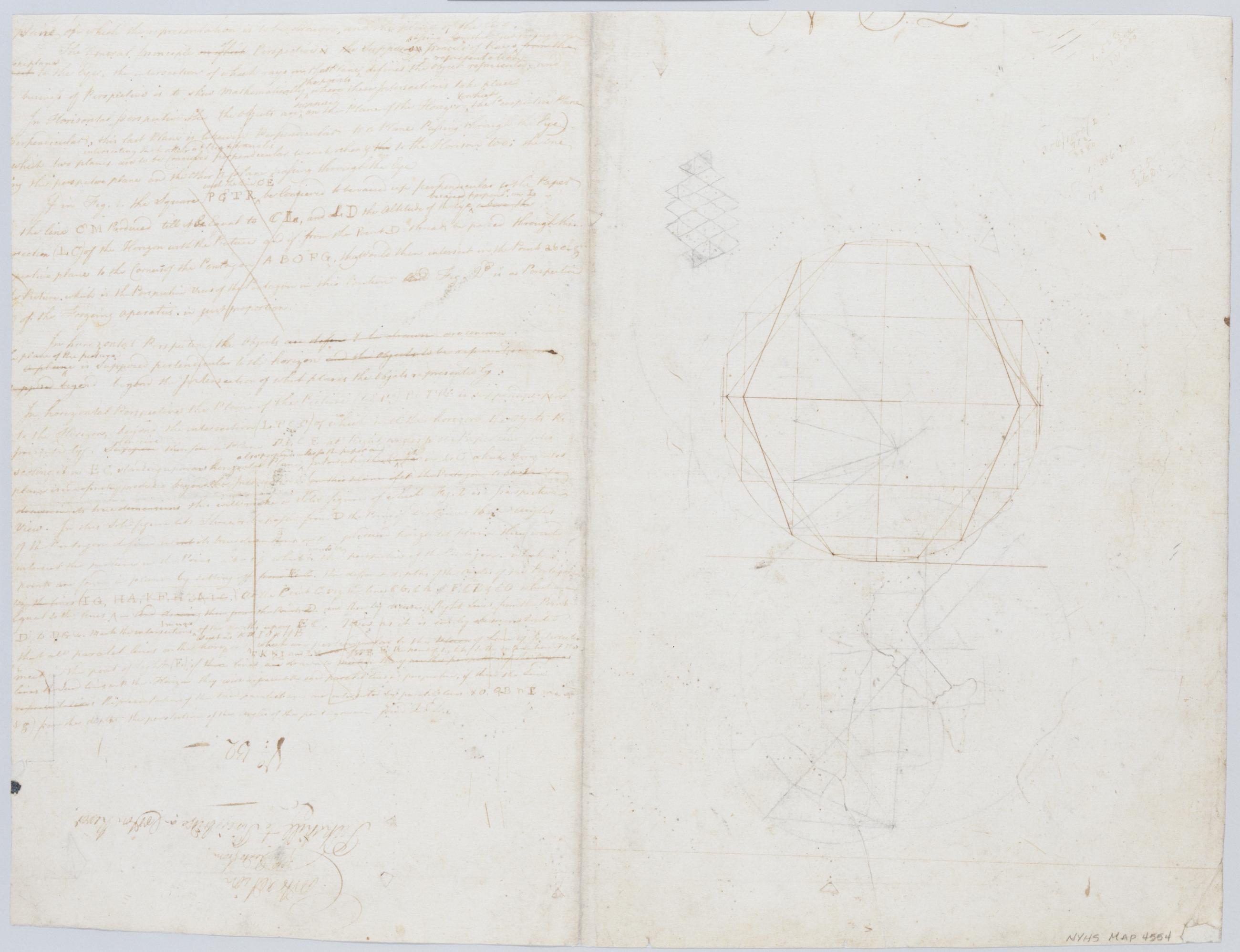
Cartographic Roads from Peekskill to Pines Bridge on Croton River, +c. No 32 / by Robert Erskine F.R.S. Geogr. A. U.S. and Assistants, recto Also in ink on verso, a crossed-out text of which 500 words are extant; incipit "plane of which the representation is to be drawn, and the place of the Eyes. [Paragraph] The General principle [on which--crossed out] of Perspective [is the--crossed out] supposes pencils of rays...." Ancillary geometric drawings in ink and pencil on recto and verso. In pencil on recto: "No 32". Military topographic map. Covers the towns of Cortlandt, Ossining, Mt. Pleasant, Yorktown and Newcastle in Westchester County, New York. View Item
Cartographic Roads from Peekskill to Pines Bridge on Croton River, +c. No 32 / by Robert Erskine F.R.S. Geogr. A. U.S. and Assistants, verso Also in ink on verso, a crossed-out text of which 500 words are extant; incipit "plane of which the representation is to be drawn, and the place of the Eyes. [Paragraph] The General principle [on which--crossed out] of Perspective [is the--crossed out] supposes pencils of rays...." Ancillary geometric drawings in ink and pencil on recto and verso. In pencil on recto: "No 32". Military topographic map. Covers the towns of Cortlandt, Ossining, Mt. Pleasant, Yorktown and Newcastle in Westchester County, New York. View Item
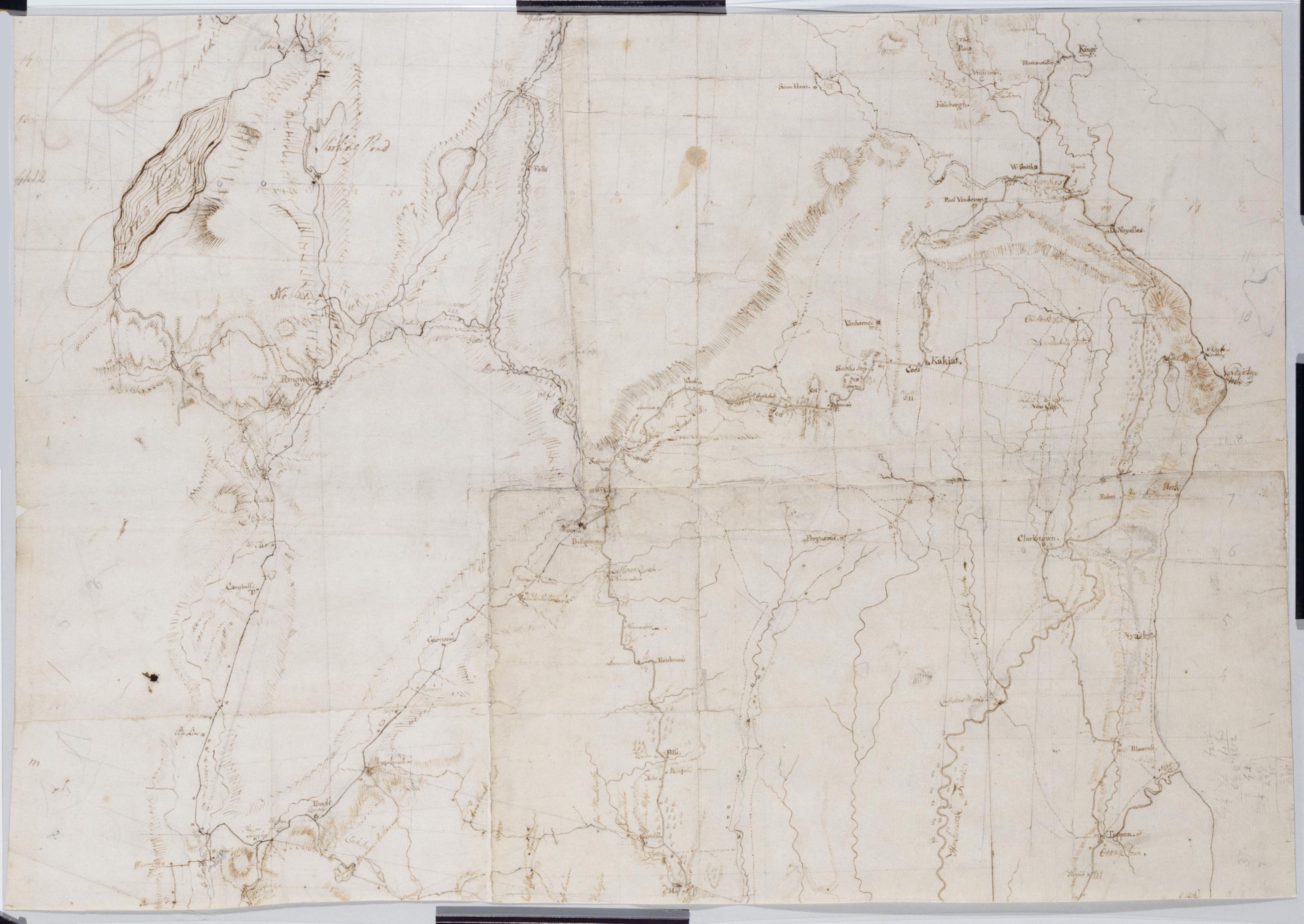
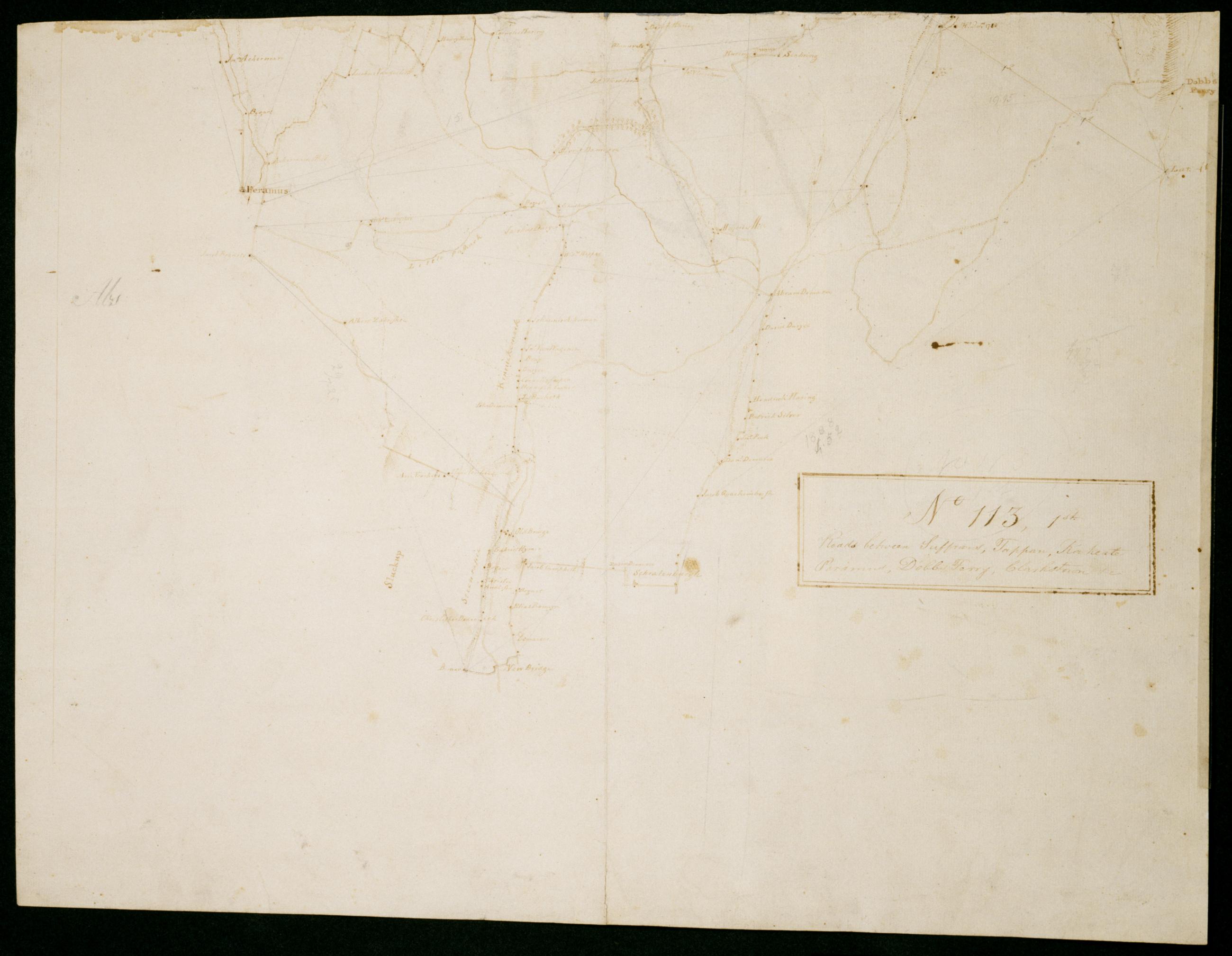
Cartographic Roads between Suffrans, Tappan, Kakeate Peramus, Dobbs Ferry, Clarkstown +c. No 113, 1st / by Robert Erskine F.R.S. Geogr. A. U.S. and Assistants, first fragment Military topographic map. Covers the townships of Orangetown, Ramapo and Clarkstown in Rockland County, New York, and of Herrington, Washington, Palisades, Midland, Ridgewood and Orvil in Bergen County, New Jersey. Shows buildings and owners' names, landforms and streams. Shows relief by hachures. Title proper from recto is the work of a later editor--Simeon DeWitt or his assign--subsequent to 1820. Title from verso is in Erskine's hand and may be cited as such. View Item
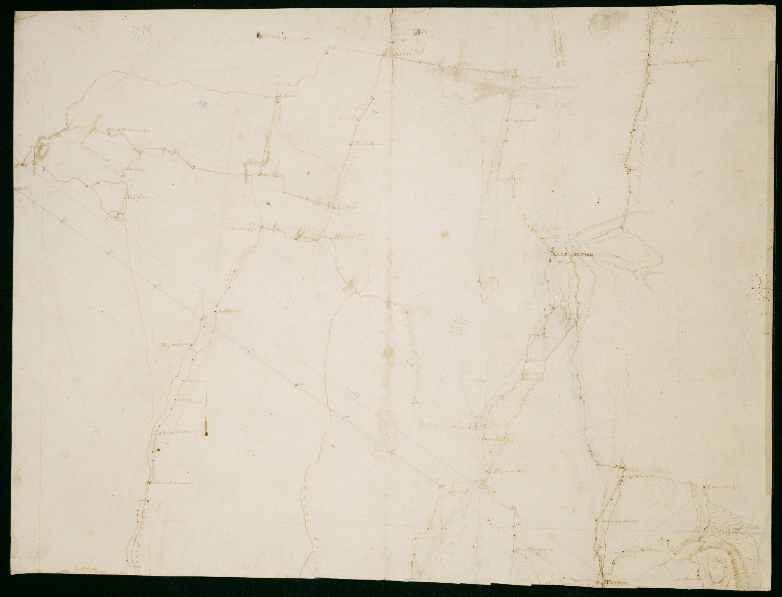
Cartographic Roads between Suffrans, Tappan, Kakeate Peramus, Dobbs Ferry, Clarkstown +c. No 113, 1st / by Robert Erskine F.R.S. Geogr. A. U.S. and Assistants, second fragment Military topographic map. Covers the townships of Orangetown, Ramapo and Clarkstown in Rockland County, New York, and of Herrington, Washington, Palisades, Midland, Ridgewood and Orvil in Bergen County, New Jersey. Shows buildings and owners' names, landforms and streams. Shows relief by hachures. Title proper from recto is the work of a later editor--Simeon DeWitt or his assign--subsequent to 1820. Title from verso is in Erskine's hand and may be cited as such. View Item
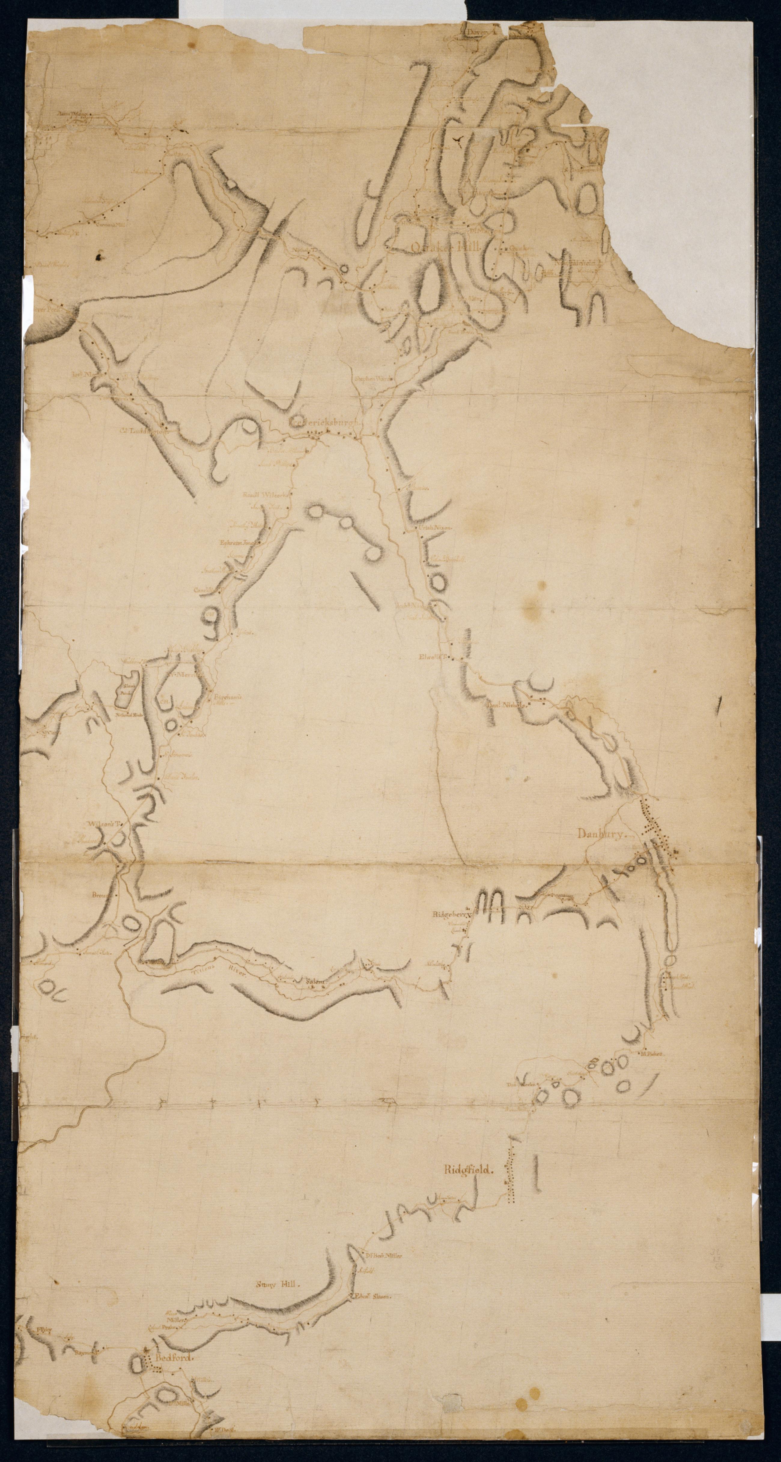
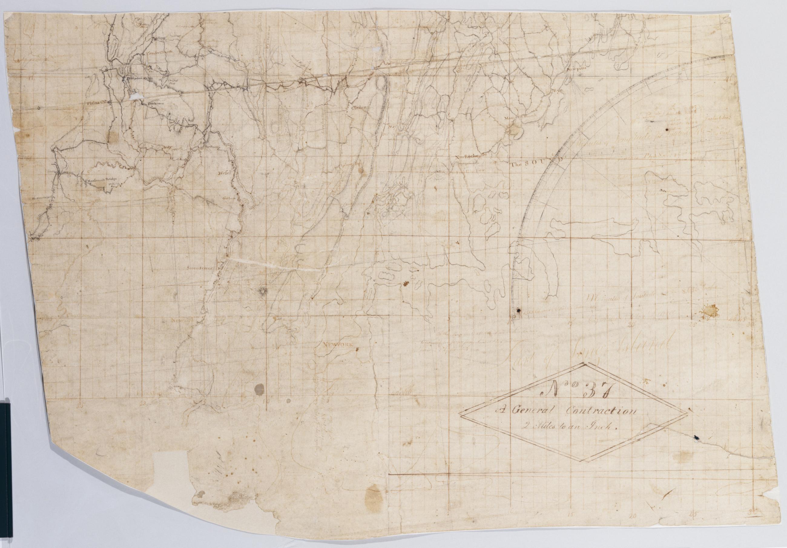
Cartographic A General Contraction 2 Miles to an Inch. No 37 / by R.E. ; by Robert Erskine F.R.S. Geogr. A. U.S. and Assistants, bottom Military topographic map. Covers the lower Hudson River Valley in New York, New Jersey and Connecticut, from Warwick (N.Y.) and Pompton Plains (N.J.) to New Milford and Danbury (Conn.), and from Newburgh (N.Y.) to Staten Island (N.Y.). Shows roads, buildings and owners' names, also landforms and streams. Shows relief by hachures. Title proper from recto is the work of a later editor--Simeon DeWitt or his assign--subsequent to 1820. Index title, both statements of responsibility, date, series title and series numbering by Erskine, but on separate index sheet filed at head of series. View Item
Cartographic A General Contraction 2 Miles to an Inch. No 37 / by R.E. ; by Robert Erskine F.R.S. Geogr. A. U.S. and Assistants, top Military topographic map. Covers the lower Hudson River Valley in New York, New Jersey and Connecticut, from Warwick (N.Y.) and Pompton Plains (N.J.) to New Milford and Danbury (Conn.), and from Newburgh (N.Y.) to Staten Island (N.Y.). Shows roads, buildings and owners' names, also landforms and streams. Shows relief by hachures. Title proper from recto is the work of a later editor--Simeon DeWitt or his assign--subsequent to 1820. Index title, both statements of responsibility, date, series title and series numbering by Erskine, but on separate index sheet filed at head of series. View Item
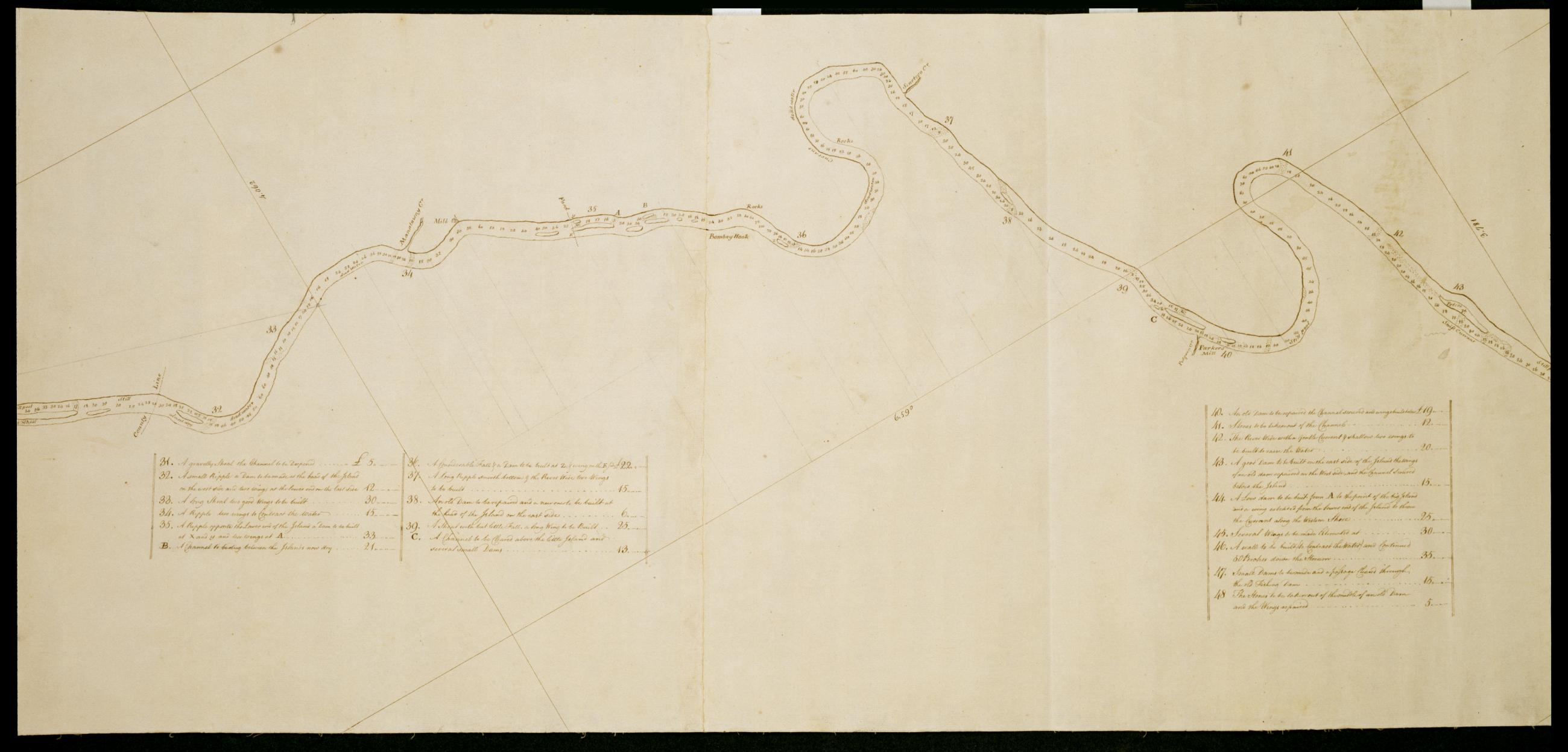
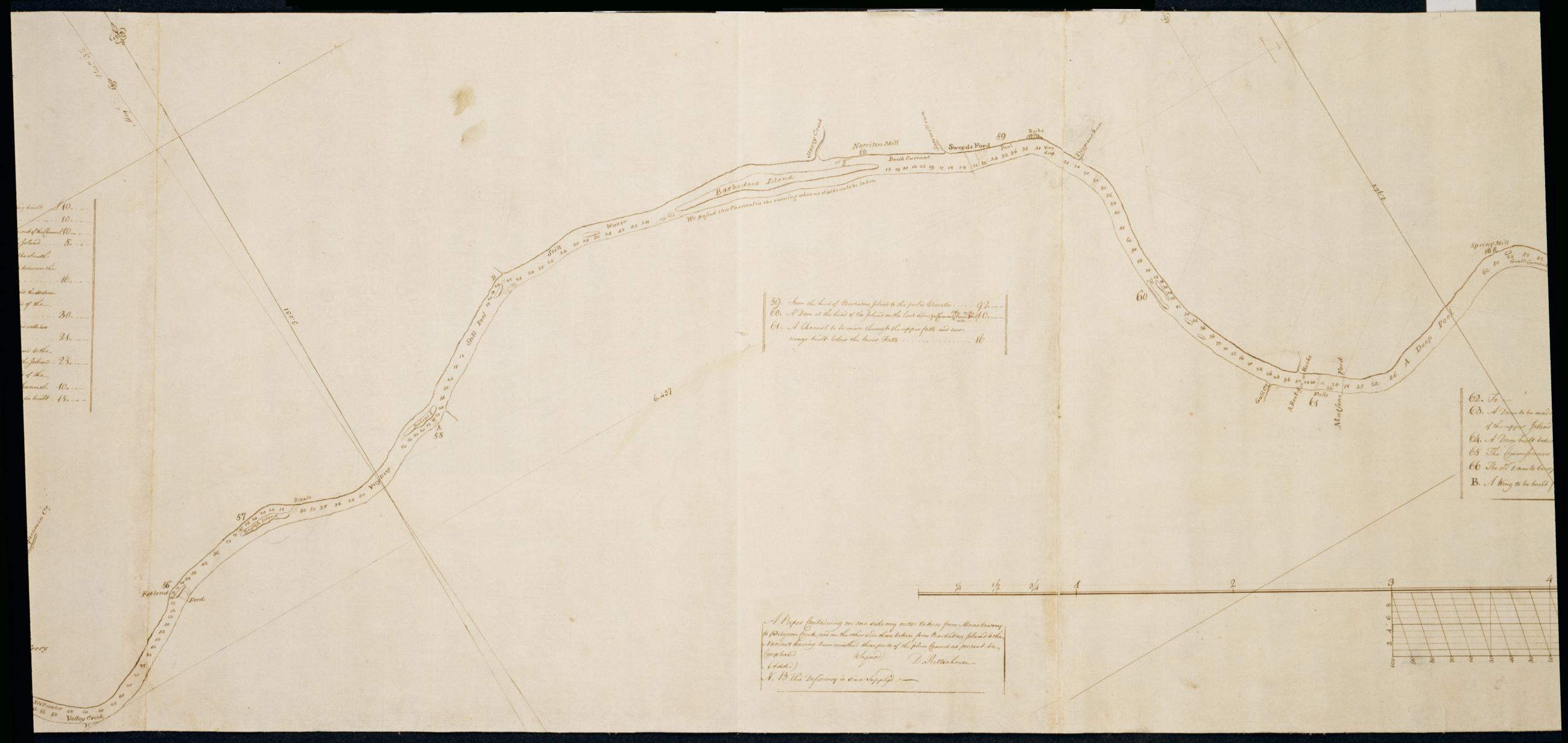
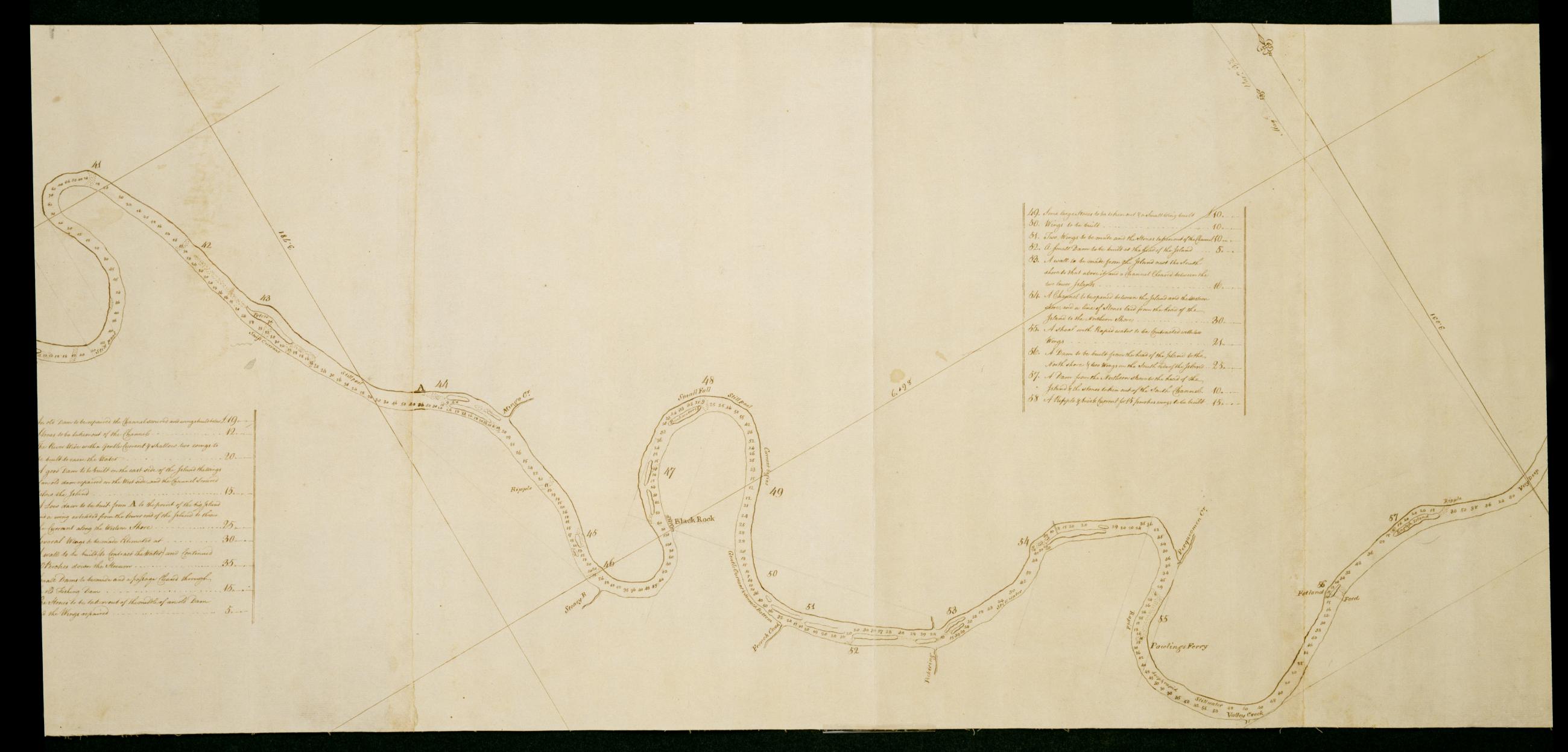
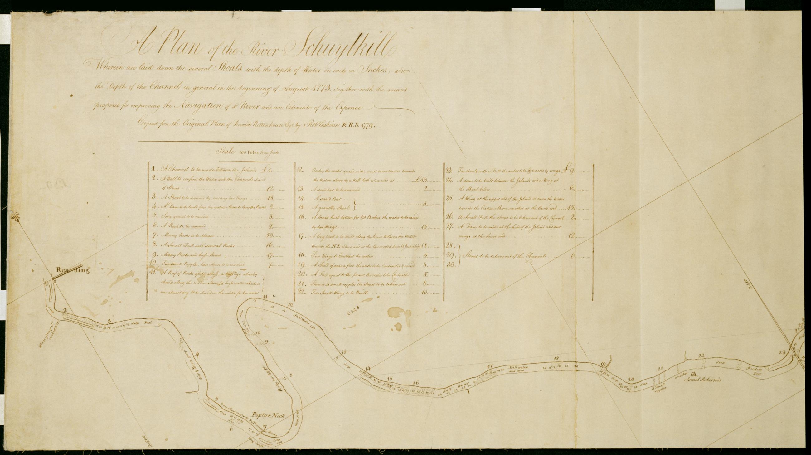
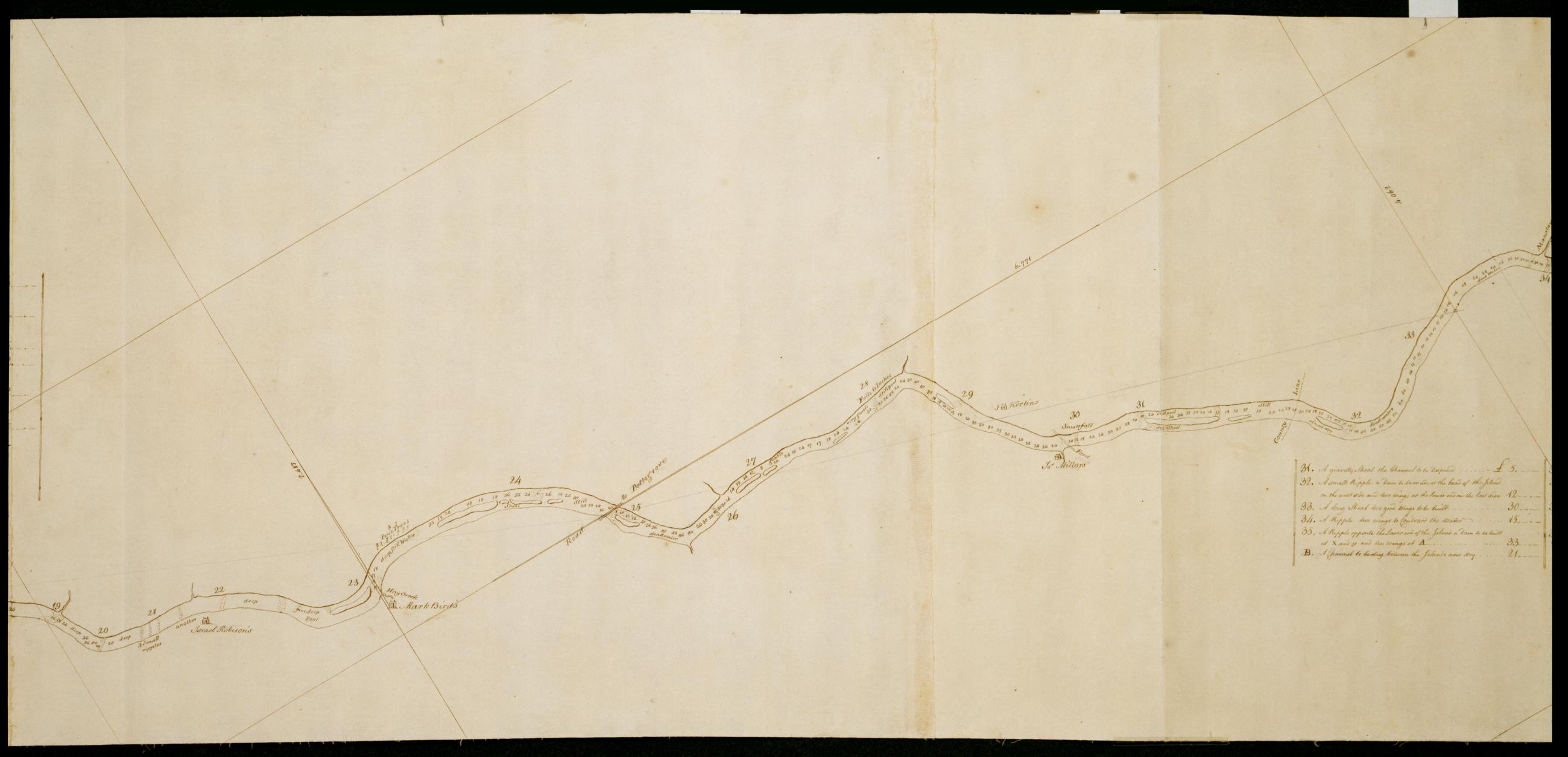
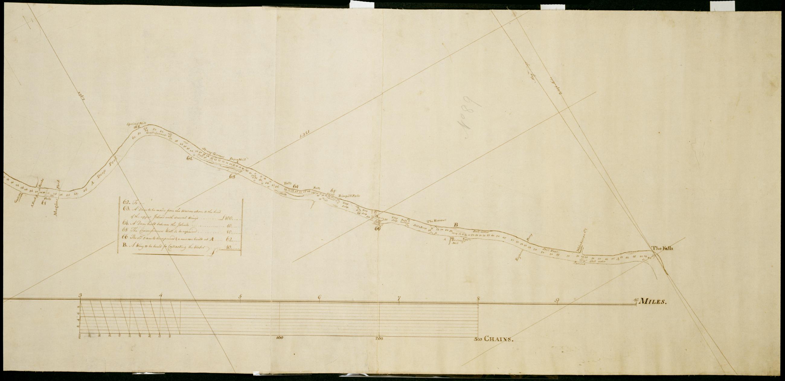
Cartographic A Plan of the River Schuylkill Wherein are laid down the several Shoals with the depth of Water on each in Inches, also the Depth of the Channel in general in the beginning of August 1773, Together with the means proposed for improving the Navigation of s Foxed, soiled, stained and creased. Mounted on cloth and cropped. In pencil on recto: "No 89". Includes index to 66 numbered features. Military topographic map. Covers the counties of Berks, Chester, Montgomery and Philadelphia, Pennsylvania, between Reading and Philadelphia. Shows river features and depths by soundings. Does not show landward features. Pen-and-ink, pencil on laid paper. Title proper and first statement of responsibility from map recto. Title number supplied by cataloger. View Item
Cartographic A Plan of the River Schuylkill Wherein are laid down the several Shoals with the depth of Water on each in Inches, also the Depth of the Channel in general in the beginning of August 1773, Together with the means proposed for improving the Navigation of s Foxed, soiled, stained and creased. Mounted on cloth and cropped. In pencil on recto: "No 89". Includes index to 66 numbered features. Military topographic map. Covers the counties of Berks, Chester, Montgomery and Philadelphia, Pennsylvania, between Reading and Philadelphia. Shows river features and depths by soundings. Does not show landward features. Pen-and-ink, pencil on laid paper. Title proper and first statement of responsibility from map recto. Title number supplied by cataloger. View Item
Cartographic A Plan of the River Schuylkill Wherein are laid down the several Shoals with the depth of Water on each in Inches, also the Depth of the Channel in general in the beginning of August 1773, Together with the means proposed for improving the Navigation of s Foxed, soiled, stained and creased. Mounted on cloth and cropped. In pencil on recto: "No 89". Includes index to 66 numbered features. Military topographic map. Covers the counties of Berks, Chester, Montgomery and Philadelphia, Pennsylvania, between Reading and Philadelphia. Shows river features and depths by soundings. Does not show landward features. Pen-and-ink, pencil on laid paper. Title proper and first statement of responsibility from map recto. Title number supplied by cataloger. View Item
Cartographic A Plan of the River Schuylkill Wherein are laid down the several Shoals with the depth of Water on each in Inches, also the Depth of the Channel in general in the beginning of August 1773, Together with the means proposed for improving the Navigation of s Foxed, soiled, stained and creased. Mounted on cloth and cropped. In pencil on recto: "No 89". Includes index to 66 numbered features. Military topographic map. Covers the counties of Berks, Chester, Montgomery and Philadelphia, Pennsylvania, between Reading and Philadelphia. Shows river features and depths by soundings. Does not show landward features. Pen-and-ink, pencil on laid paper. Title proper and first statement of responsibility from map recto. Title number supplied by cataloger. View Item
Cartographic A Plan of the River Schuylkill Wherein are laid down the several Shoals with the depth of Water on each in Inches, also the Depth of the Channel in general in the beginning of August 1773, Together with the means proposed for improving the Navigation of s Foxed, soiled, stained and creased. Mounted on cloth and cropped. In pencil on recto: "No 89". Includes index to 66 numbered features. Military topographic map. Covers the counties of Berks, Chester, Montgomery and Philadelphia, Pennsylvania, between Reading and Philadelphia. Shows river features and depths by soundings. Does not show landward features. Pen-and-ink, pencil on laid paper. Title proper and first statement of responsibility from map recto. Title number supplied by cataloger. View Item
Cartographic A Plan of the River Schuylkill Wherein are laid down the several Shoals with the depth of Water on each in Inches, also the Depth of the Channel in general in the beginning of August 1773, Together with the means proposed for improving the Navigation of s Foxed, soiled, stained and creased. Mounted on cloth and cropped. In pencil on recto: "No 89". Includes index to 66 numbered features. Military topographic map. Covers the counties of Berks, Chester, Montgomery and Philadelphia, Pennsylvania, between Reading and Philadelphia. Shows river features and depths by soundings. Does not show landward features. Pen-and-ink, pencil on laid paper. Title proper and first statement of responsibility from map recto. Title number supplied by cataloger. View Item
Cartographic A Plan of the River Schuylkill Wherein are laid down the several Shoals with the depth of Water on each in Inches, also the Depth of the Channel in general in the beginning of August 1773, Together with the means proposed for improving the Navigation of s Foxed, soiled, stained and creased. Mounted on cloth and cropped. In pencil on recto: "No 89". Includes index to 66 numbered features. Military topographic map. Covers the counties of Berks, Chester, Montgomery and Philadelphia, Pennsylvania, between Reading and Philadelphia. Shows river features and depths by soundings. Does not show landward features. Pen-and-ink, pencil on laid paper. Title proper and first statement of responsibility from map recto. Title number supplied by cataloger. View Item