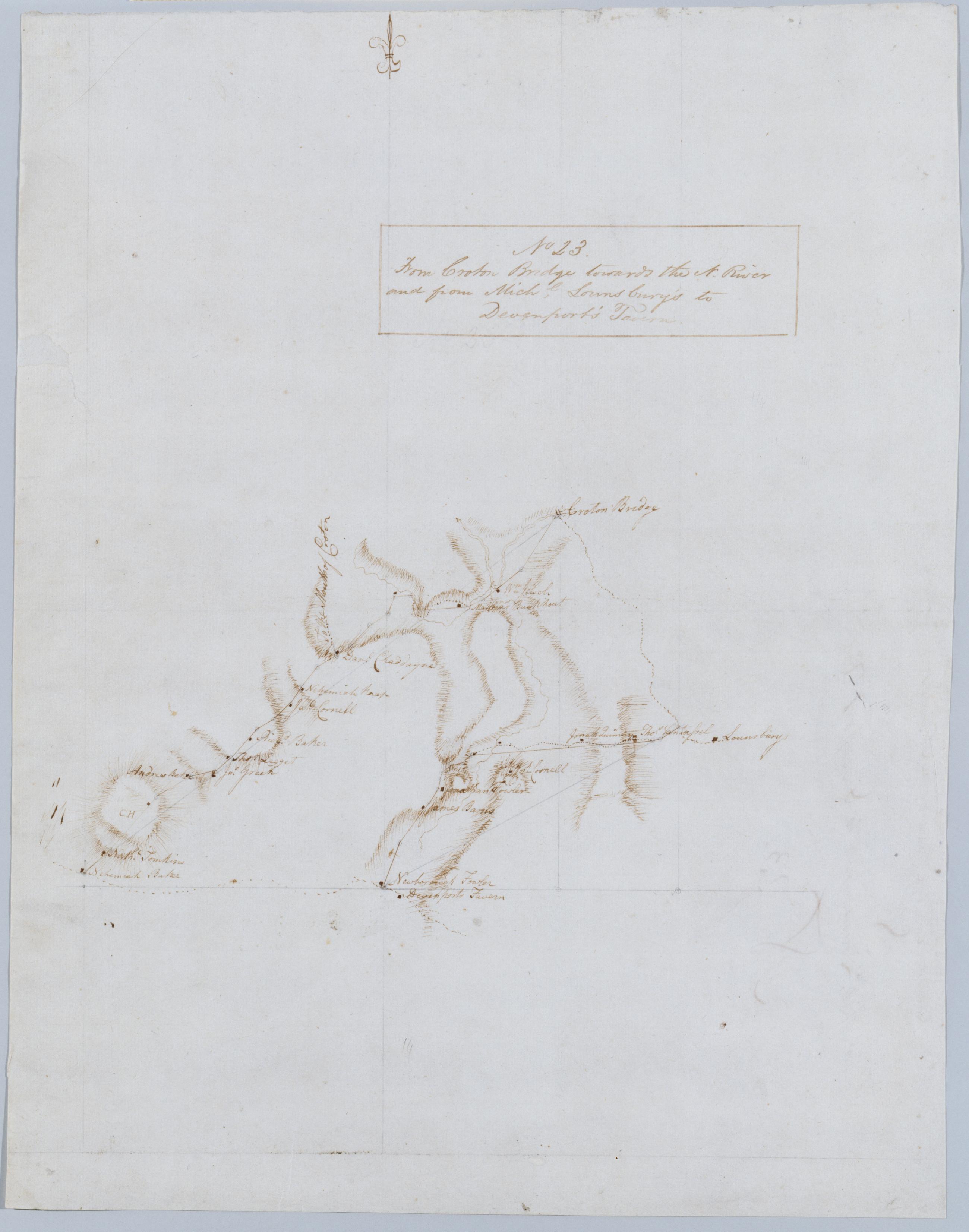
Cartographic From Croton Bridge towards the N. River and from Michl. Lounsbury's to Devenport's Tavern. No 23 / by Robert Erskine F.R.S. Geogr. A. U.S. and Assistants. Foxed, creased and abraded. Mounted on cloth, bound and cropped, disbound and silked by subsequent owners. Cleaned after removal of backings 1999; some fill remains. Sheathed in mylar. In ink on verso: "No 23". Military topographic map. Covers the towns of Yorktown and Newcastle in Westchester County, New York. Map shows roads running through Kitchawan, Pine Bridge and Tompkins Corners. Also shows buildings and owners' names, landforms and streams. Pen-and-ink, pencil on laid paper. Shows relief by hachures. View Item
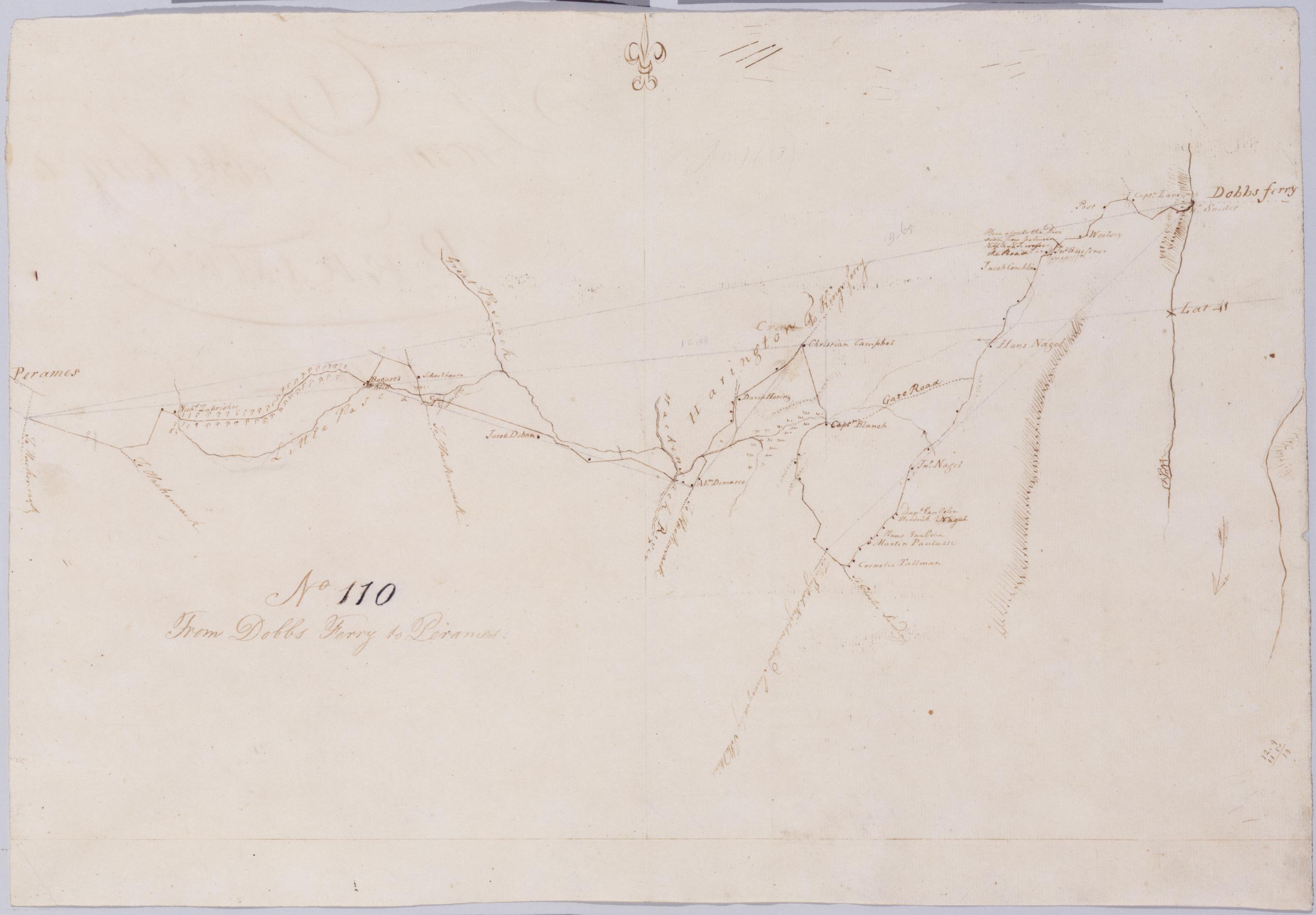
Cartographic From Dobbs Ferry to Peramus. No 110 / by Robert Erskine F.R.S. Geogr. A. U.S. and Assistants. In erased pencil on recto: "No 110". Military topographic map. Covers the townships of Orangetown in Rockland County, New York, and of Harrington and Washington in Bergen County, New Jersey. Shows roads running through Sneden Landing N.Y., Harrington Park, Westwood and Paramus N.J. Also shows buildings and owners' names, landforms and streams. Pen-and-ink, pencil on laid paper. Shows relief by hachures. Soiled, creased and abraded. Mounted on cloth, bound and cropped, disbound and silked by subsequent owners. Cleaned after removal of backings 1999; some fill remains. Sheathed in mylar. View Item
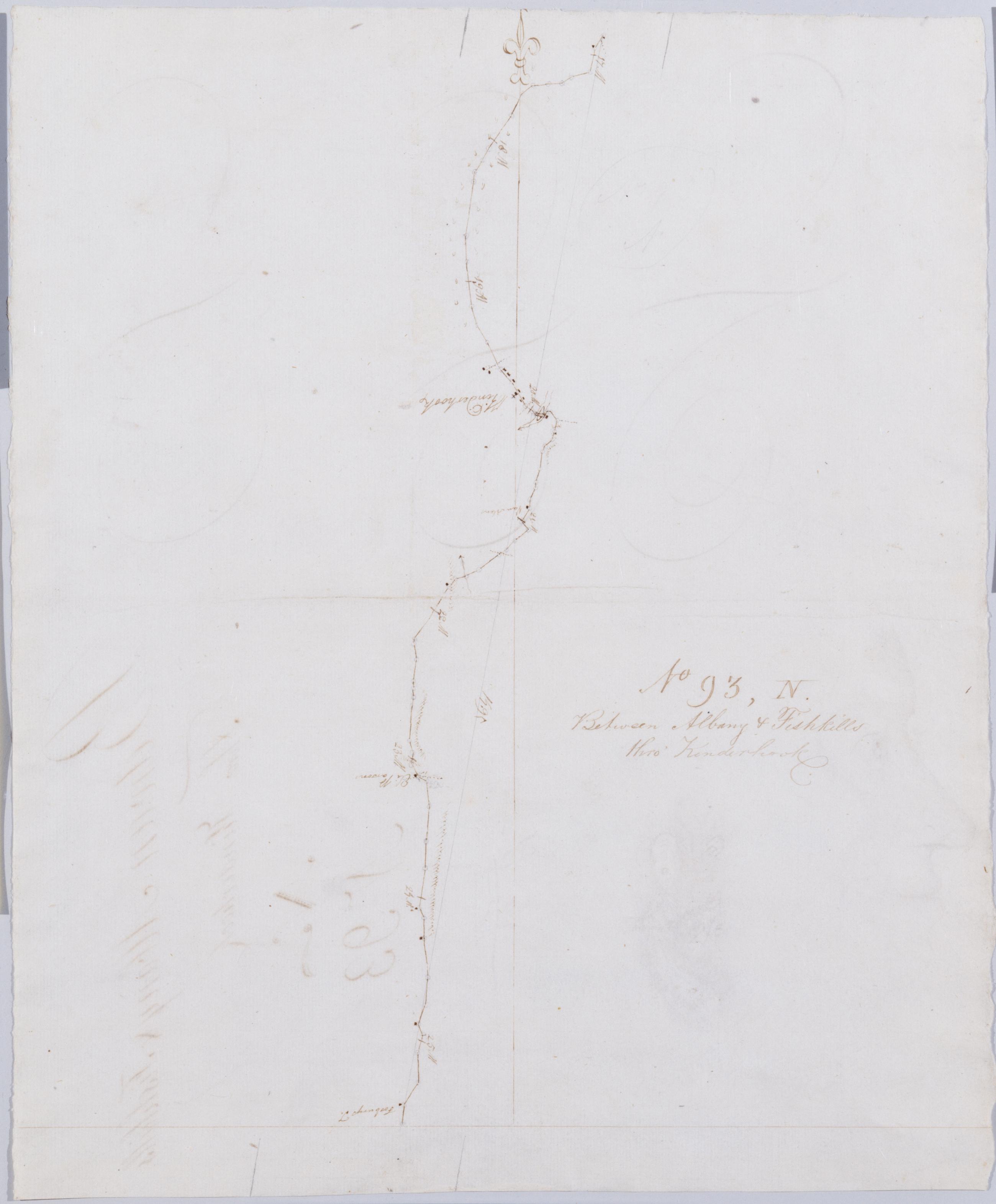
Cartographic Between Albany + Fishkills thro' Kinderhook No 93, N / by Robert Erskine F.R.S. Geogr. A. U.S. and Assistants. Also on verso: fully developed hatchures of unidentified mountains and the profile portrait of a youthful man, both in Erskine's hand. It is possible that the portrait is of Erskine himself; no other portrait is known. In erased pencil on recto: "No 93 N". In ink on verso: "N N N". Military topographic map. Covers the townships of Kinderhook and Ghent in Columbia County, New York. Shows roads running through Kinderhook and West Ghent. Also shows buildings and owners' names, landforms and streams. Pen-and-ink, pencil on laid paper. Shows relief by hachures. Soiled, creased and abraded. View Item
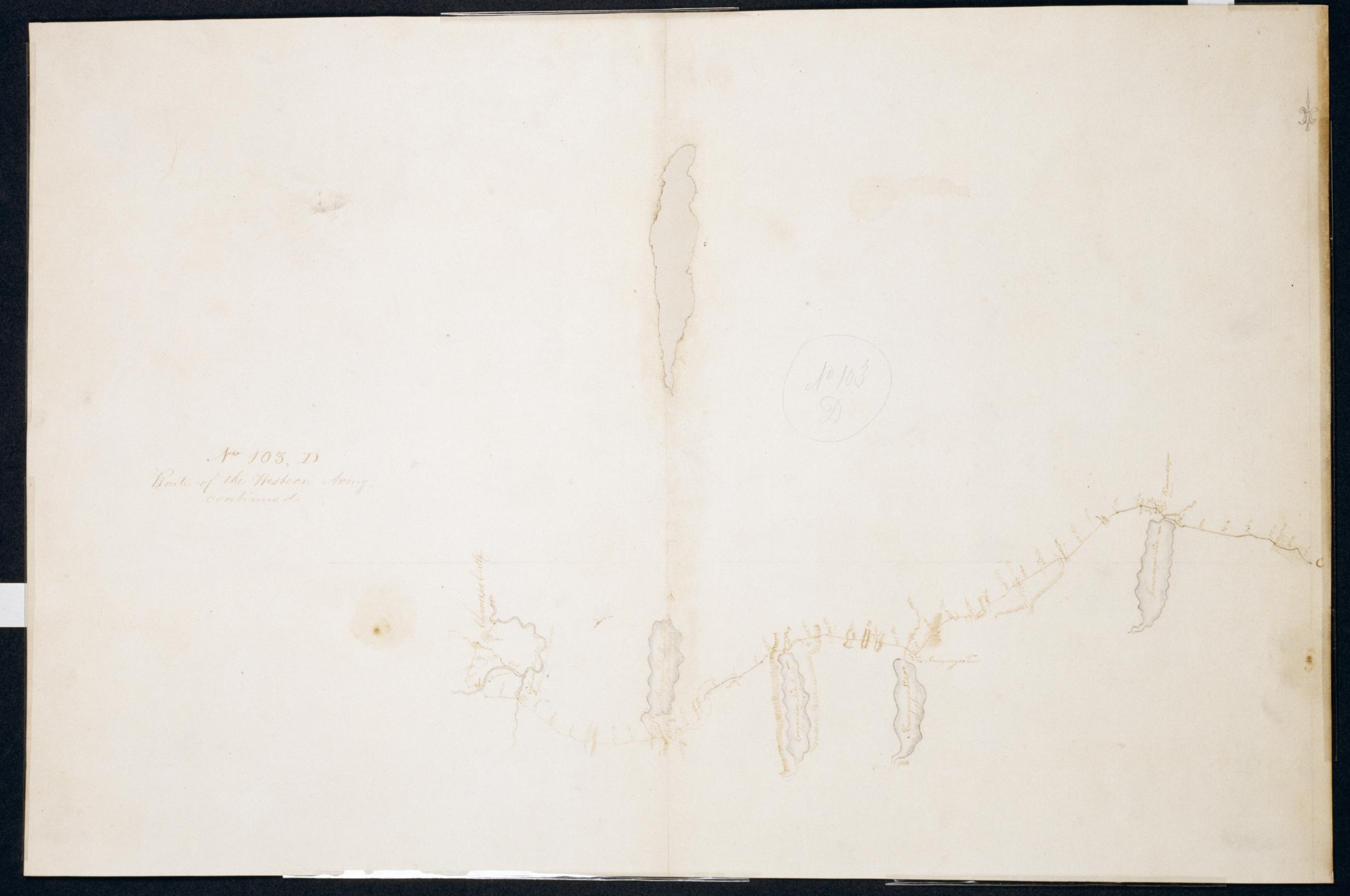
Cartographic Route of the Western Army continued. No. 103, D / by Lt. Lodge ; by Robert Erskine F.R.S. Geogr. A. U.S. and Assistants. Creased, soiled, stained, frayed and abraded. Mounted on cloth, bound and cropped, disbound and silked by subsequent owners. Cleaned after removal of backings 1999; some fill remains. Sheathed in mylar. Imperfect: lacking 3 x 14 cm. at upper center of map. In ink on verso "D No. 103". In pencil on recto: "No 103 D". Military topographic map. Covers the counties of Ontario and Livingston in New York. Also shows landforms and streams. Pen-and-ink, pencil on laid paper. Shows relief by hachures. View Item
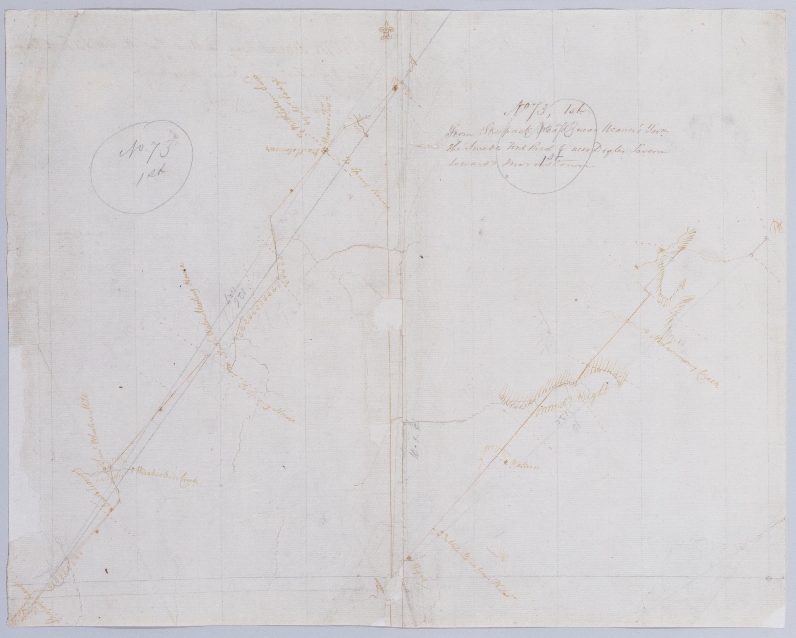
Cartographic From Skeepack Road near Weaver's Tavn. the Swede Ford Road to near Doyles Tavern towards Morristown. No 73, 1st / by Robert Erskine F.R.S. Geogr. A. U.S. and Assistants. Creased, torn, frayed and abraded. Mounted on cloth, bound and cropped, disbound and silked by subsequent owners. Cleaned after removal of backings 1999; some fill remains. Sheathed in mylar. Imperfect: lacking 2 x 2 cm. at center. In pencil on recto: "No 73 1st" (twice). Military topographic map. Covers Bucks and Montgomery counties, Pennsylvania. Shows roads running through Norristown, North Wales, New Britain and Doylestown. Also shows buildings and owners' names, landforms and streams. Pen-and-ink, pencil on laid paper. Shows relief by hachures. View Item
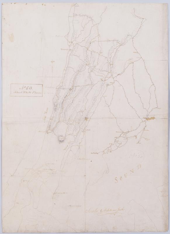
Cartographic About White Plains. No 60 / by Robert Erskine F.R.S. Geogr. A. U.S. and Assistants. In ink on recto: geometrical sketches, "No. 60". In pencil on recto: "No 60". Military topographic map. Covers most of Westchester County, New York and western Fairfield County, Connecticut; also covers northern New York City. Shows roads, buildings and owners' names, also landforms and streams. Pen-and-ink, pencil on laid paper. Shows relief by hachures. Stained, soiled, foxed, creased, frayed and abraded. Mounted on cloth, bound and cropped, disbound and silked by subsequent owners. Cleaned after removal of backings 1999; some fill remains. Sheathed in mylar. View Item
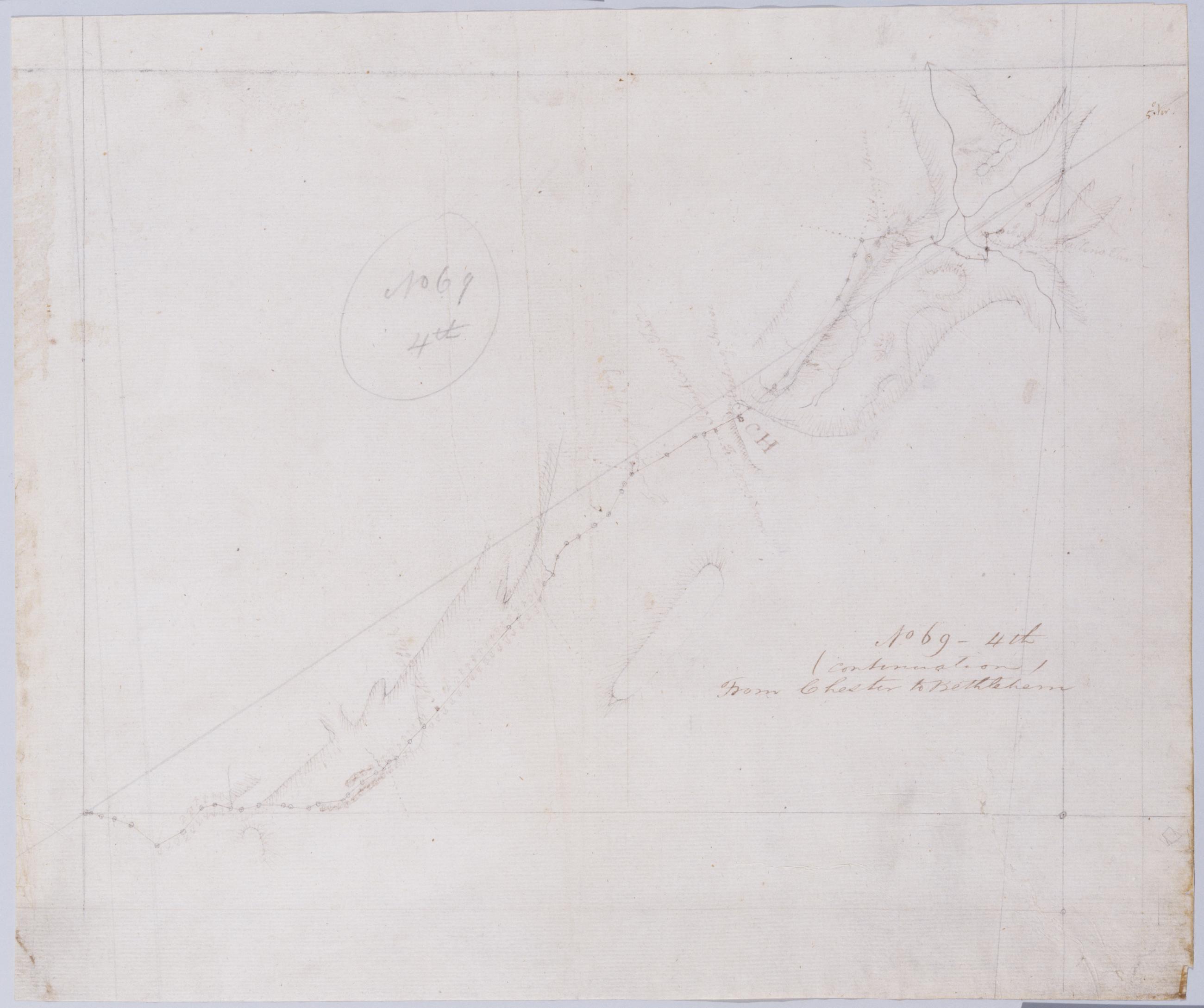
Cartographic (Continuation) From Chester to Bethlehem. No 69-4th / by Robert Erskine F.R.S. Geogr. A. U.S. and Assistants. In pencil on recto: "No 69 4th". Military topographic map. Covers the townships of Lafayette and Hardyston in Sussex County, New Jersey. Shows roads running through Hamburg and North Church. Also shows buildings and owners' names, landforms and streams. Pen-and-ink, pencil on laid paper. Shows relief by hachures. Stained, creased and abraded. Mounted on cloth, bound and cropped, disbound and silked by subsequent owners. Cleaned after removal of backings 1999; some fill remains. Sheathed in mylar. View Item
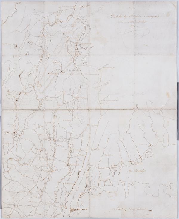
Cartographic Sketch : 1778 / by R Erskine F.R.S., Geographer to the army of the United States. Military topographic map. Covers western Connecticut, the southernmost tip of New York and northwestern New Jersey. Pen-and-ink, pencil on laid paper. Shows relief by hachures and pictorially. Stained, soiled, foxed, creased, frayed and abraded. Mounted on cloth, bound and cropped, disbound and silked by subsequent owners. Cleaned after removal of backings 1999; some fill remains. Newly backed with China paper. Sheathed in mylar. Title proper and statement of responsibility from recto is original. Watermark: "L V GERREVINK" beneath crest, similar to Gravell and Miller foreign watermark no. View Item
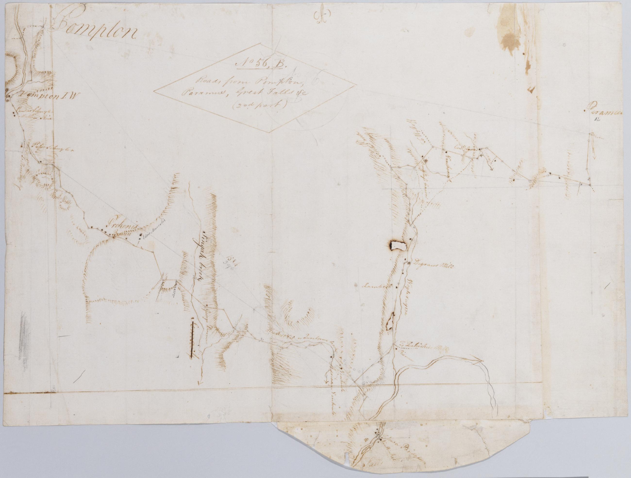
Cartographic Roads from Pompton, Paramus, Great Falls +c (2nd part) No 56, B / by Robert Erskine F.R.S. Geogr. A. U.S. and Assistants. In ink on verso: "No. 56 B-". In pencil on recto: "No 56 B". Military topographic map. Covers the townships of Wayne, Manchester, Ridgewood and Saddle River in Passaic County, New Jersey. Shows roads running through Pompton, Haledon, Goffle, Van Windle, Midland Park, Ridgewood and Paramus. Also shows buildings and owners' names, landforms and streams. Pen-and-ink, pencil on laid paper. Shows relief by hachures. Title proper from recto is the work of a later editor--Simeon DeWitt or his assign--subsequent to 1820. View Item
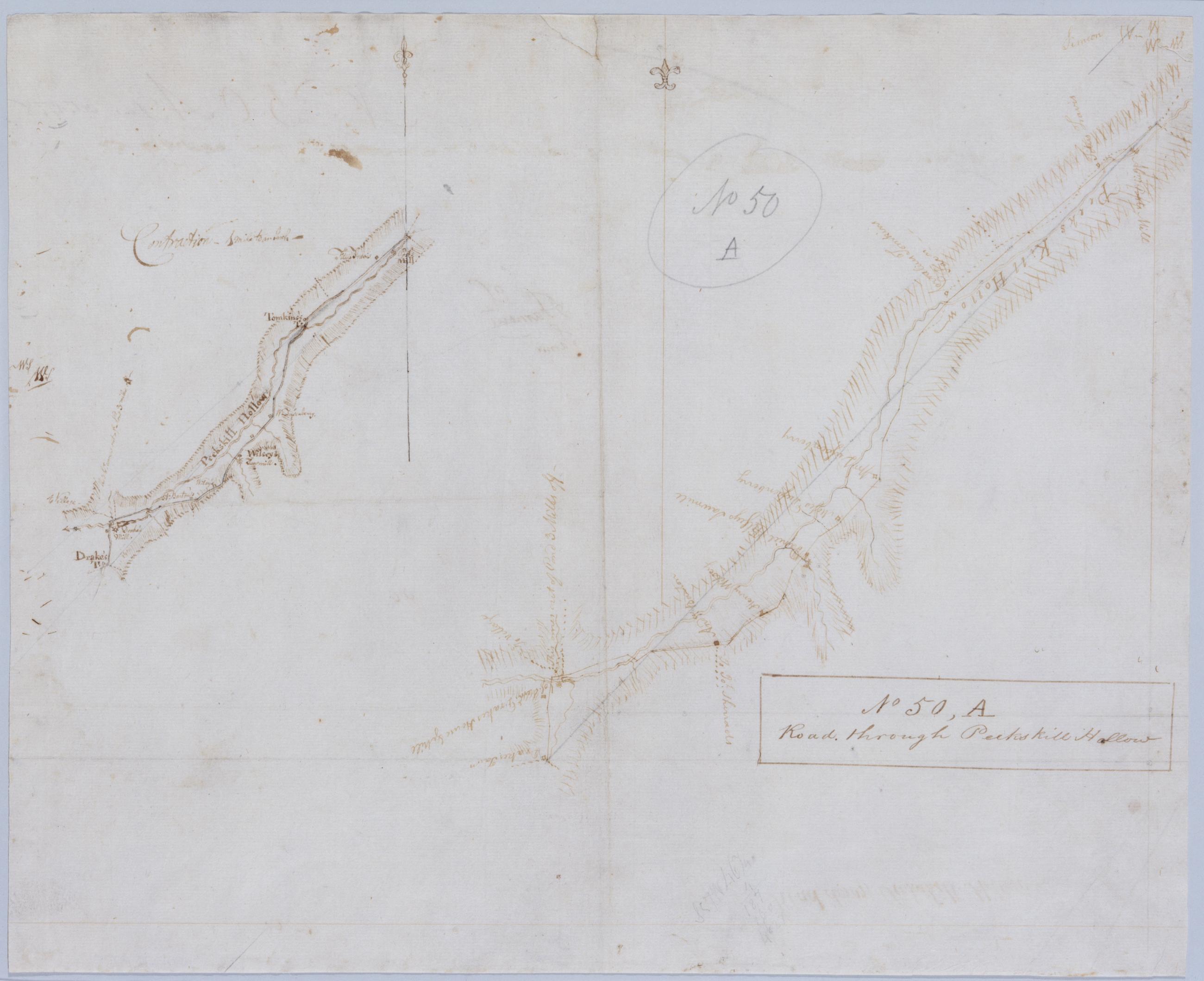
Cartographic Road through Peekskill Hollow. No 50, A / by Robert Erskine F.R.S. Geogr. A. U.S. and Assistants. Also in ink on verso: "No. 50A. Done Octr. 1778", "of Famous Samuel". Foxed, creased and abraded. Mounted on cloth, bound and cropped, disbound and silked by subsequent owners. Cleaned after removal of backings 1999; some fill remains. Sheathed in mylar. In pencil on recto: "No 50 A". Inset map or "contraction" covers same area at "1 mile to an Inch--" i.e., 1:63,360. Military topographic map. Covers the towns of Putnam Valley and Carmel in Putnam County, New York. Show roads running through Putnam Valley, Adams Corners and Tompkins Corners. View Item
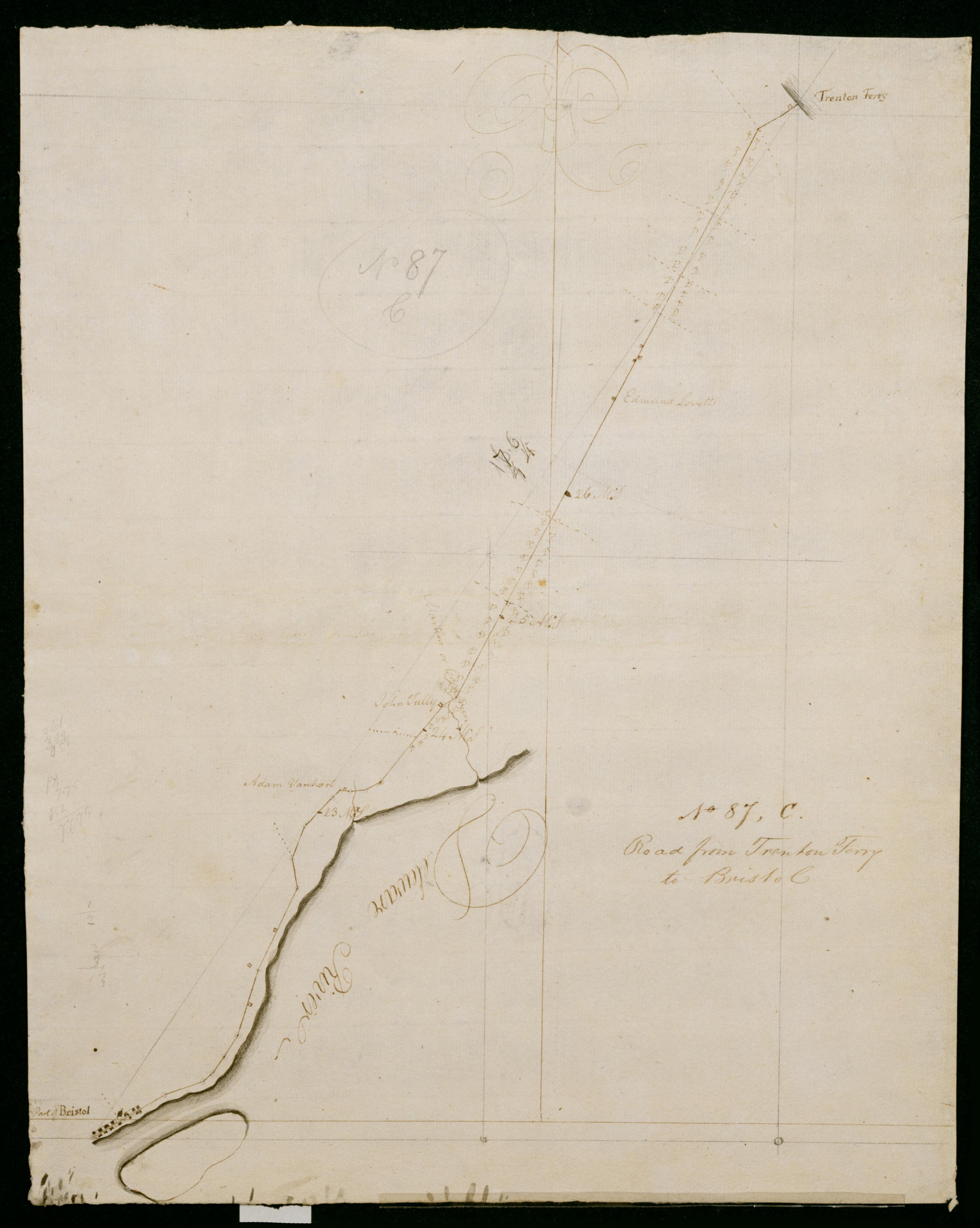
Cartographic Road from Trenton Ferry to Bristol. No 87, C / by Robert Erskine F.R.S. Geogr. A. U.S. and Assistants. In pencil on recto: "No 87 C". Military topographic map. Covers the townships of Falls and Bristol in Bucks County, Pennsylvania. Shows roads running from Trenton, New Jersey, through Morrisville, Wheat Sheaf, Tullytown and Bristol, Pennsylvania. Also shows buildings and owners' names, landforms and streams. Pen-and-ink, pencil on laid paper. Shows relief by hachures. Soiled, foxed, creased, frayed and abraded. Mounted on cloth, bound, disbound and silked by subsequent owners. Cleaned after removal of backings 1999; some fill remains. Sheathed in mylar. Title proper also in ink on verso. View Item
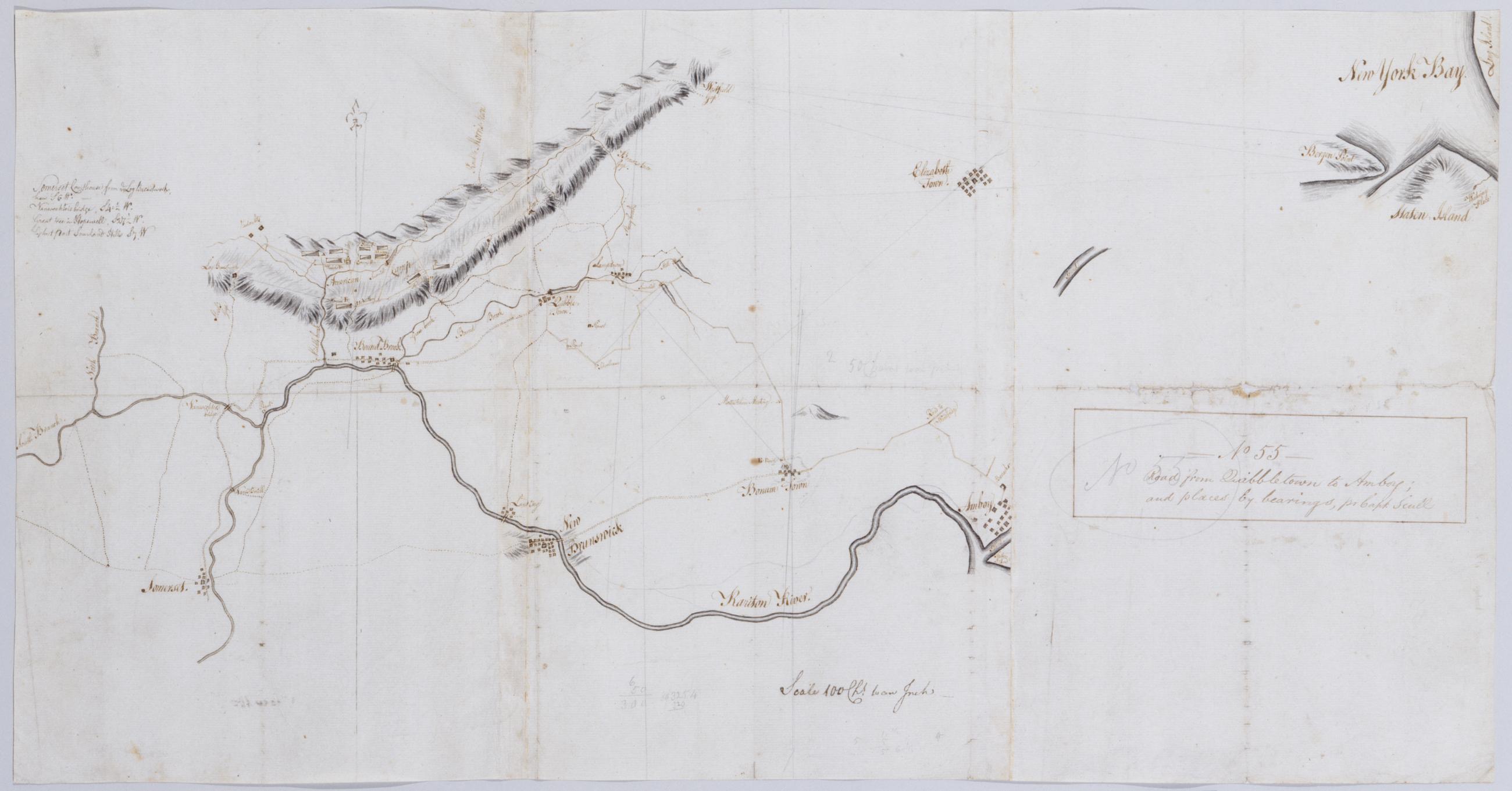
Cartographic Road from Quibbletown to Amboy; and places by bearings. No 55 / by Robert Erskine F.R.S. Geogr. A. U.S. and Assistants ; pr Capt. Scull. Badly foxed, creased, frayed and abraded. Mounted on cloth, bound and cropped, disbound and silked by subsequent owners. Cleaned after removal of backings 1999; some fill remains. Sheathed in mylar. In ink on verso: "Elizabeth Amboy A", "No. 55". In pencil on recto: "No 55". Military topographic map. Covers Somerset and Middlesex Counties in New Jersey and Richmond County in New York. View Item
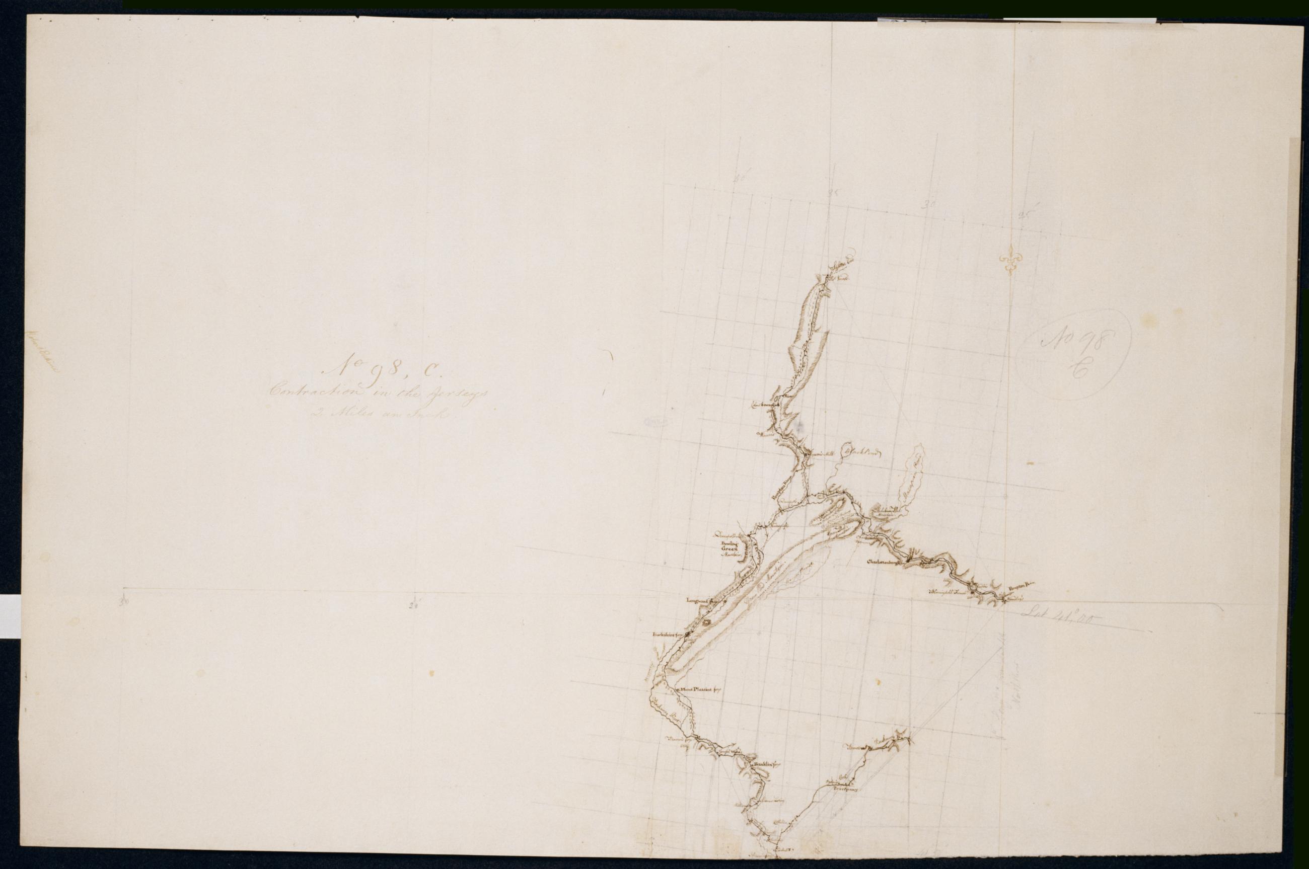
Cartographic Contraction in the Jerseys. No 98, C / Large Paper by Capt. Scull ; by Robert Erskine F.R.S. Geogr. A. U.S. and Assistants. Foxed, stained, soiled, creased and abraded. Mounted on cloth, bound and cropped, disbound and silked by subsequent owners. Cleaned after removal of backings 1999; some fill remains. Sheathed in mylar. In ink on verso: "No. 98 C". In pencil on recto and twice on verso: "No. 98 C". Military topographic map. Covers parts of Morris, Passaic and Sussex counties in New Jersey. Also shows buildings and owners' names, landforms and streams. Pen-and-ink, pencil on laid paper. Shows relief by hachures. View Item
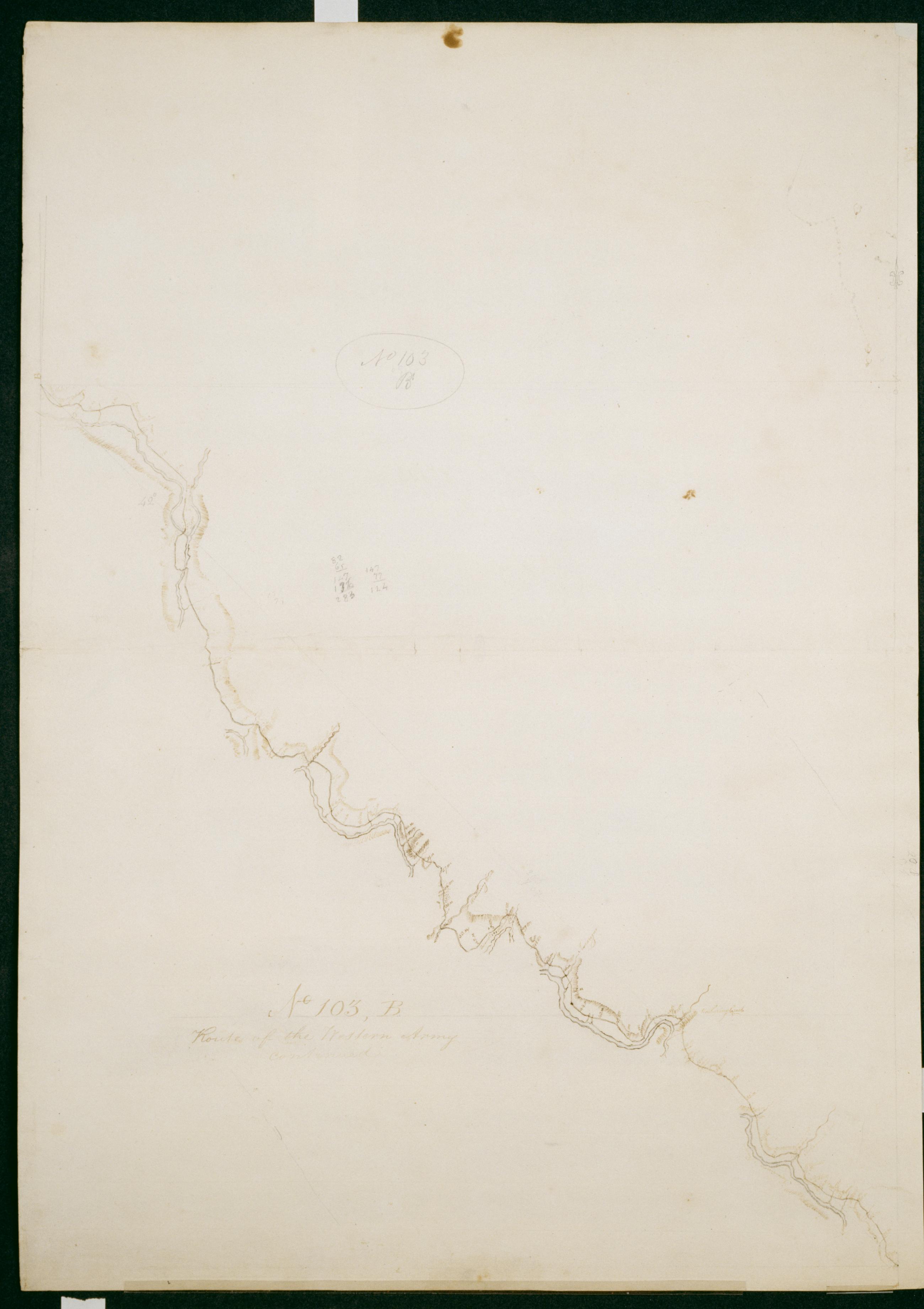
Cartographic Route of the Western Army continued. No. 103, B / by Lt. Lodge ; by Robert Erskine F.R.S. Geogr. A. U.S. and Assistants. Creased, soiled, stained and abraded. Mounted on cloth, bound and cropped, disbound and silked by subsequent owners. Cleaned after removal of backings 1999; some fill remains. Sheathed in mylar. In ink on verso "B No. 103-". In pencil on recto: "No 103 B". Military topographic map. Covers the counties of Wyoming and Bradford in Pennsylvania and of Chemung in New York. Also shows landforms and streams. Pen-and-ink, pencil on laid paper. Shows relief by hachures. Title proper from recto is the work of a later editor--Simeon DeWitt or his assign--subsequent to 1820. View Item
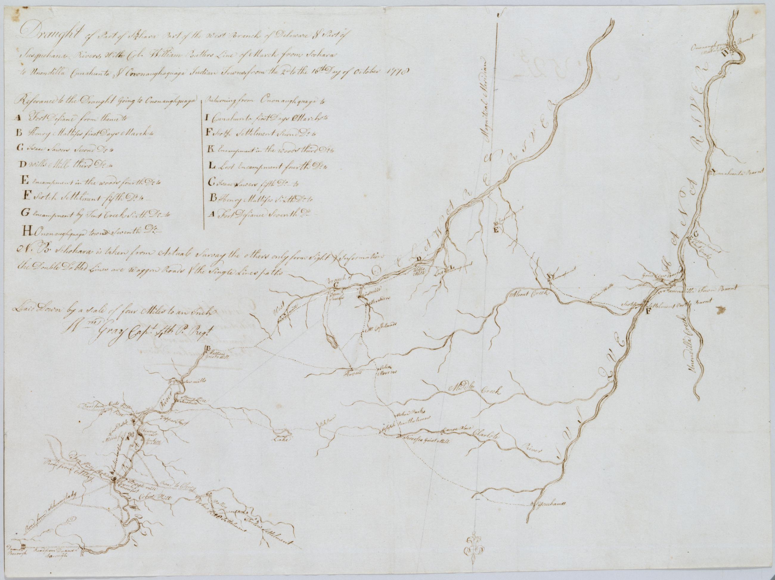
Cartographic Draught of Part of Schohara Part of the West Branch of Delaware & Part of Susquehana Rivers With Col. William Butlers Line of March from Schohara to Unendilla Cunahunta & Ononaughaquaga Indian Towns from the 2d to the 16th Day of October 1778 / by Robert Index title: Part of the Susquehanna & Delaware; Ononoughquago &c. 65. Foxed, creased, frayed and lightly soiled. Sheathed in mylar. Includes a day by day key to Butler's march. Includes text: "N.B. Schohara is taken from Actual Survey the others only from Sight & Information the Double Dotted Lines are Waggon Roads & the Single Lines paths". Military topographic map. Covers Chenango, Delaware, Otsego, Schoharie and Schenectady counties in New York. View Item
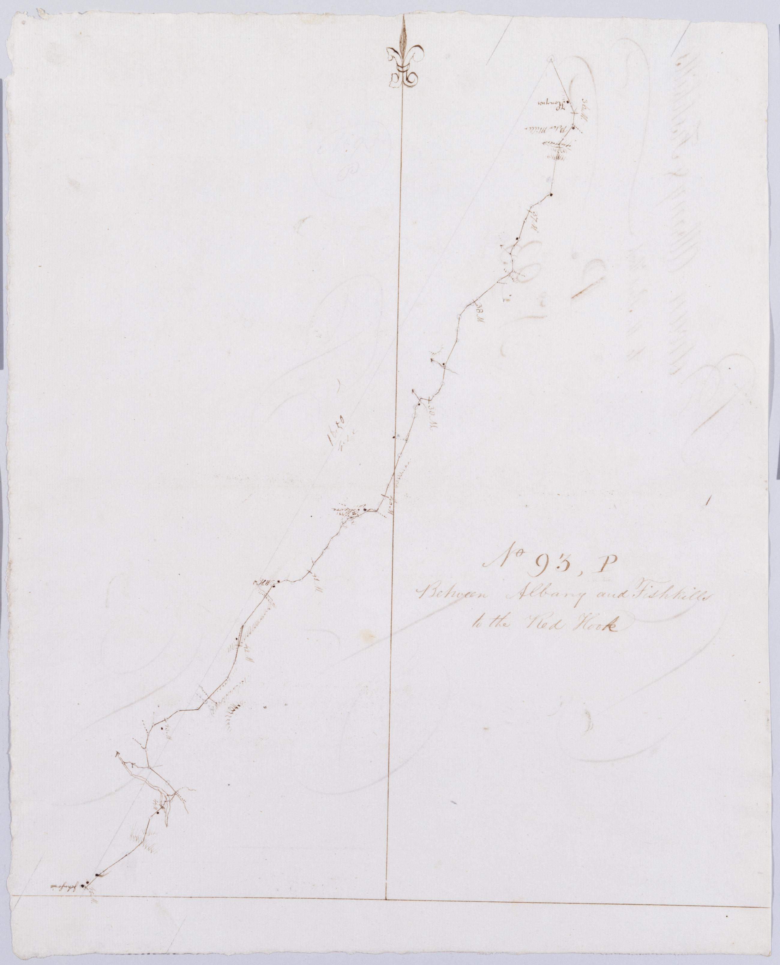
Cartographic Between Albany and Fishkills to the Red Hook. No 93, P / by Robert Erskine F.R.S. Geogr. A. U.S. and Assistants. Foxed, soiled, creased and abraded. Mounted on cloth, bound, disbound and silked by subsequent owners. Cleaned after removal of backings 1999; some fill remains. Sheathed in mylar. In erased pencil on recto: "No 93 P". In ink on verso: "P P P p". Military topographic map. Covers the townships of Claverack, Livingston and Clermont in Columbia County, New York. Shows roads running through Humphreysville, Livingston, Blue Store and Clermont. Also shows buildings and owners' names, landforms and streams. Pen-and-ink, pencil on laid paper. Shows relief by hachures. View Item
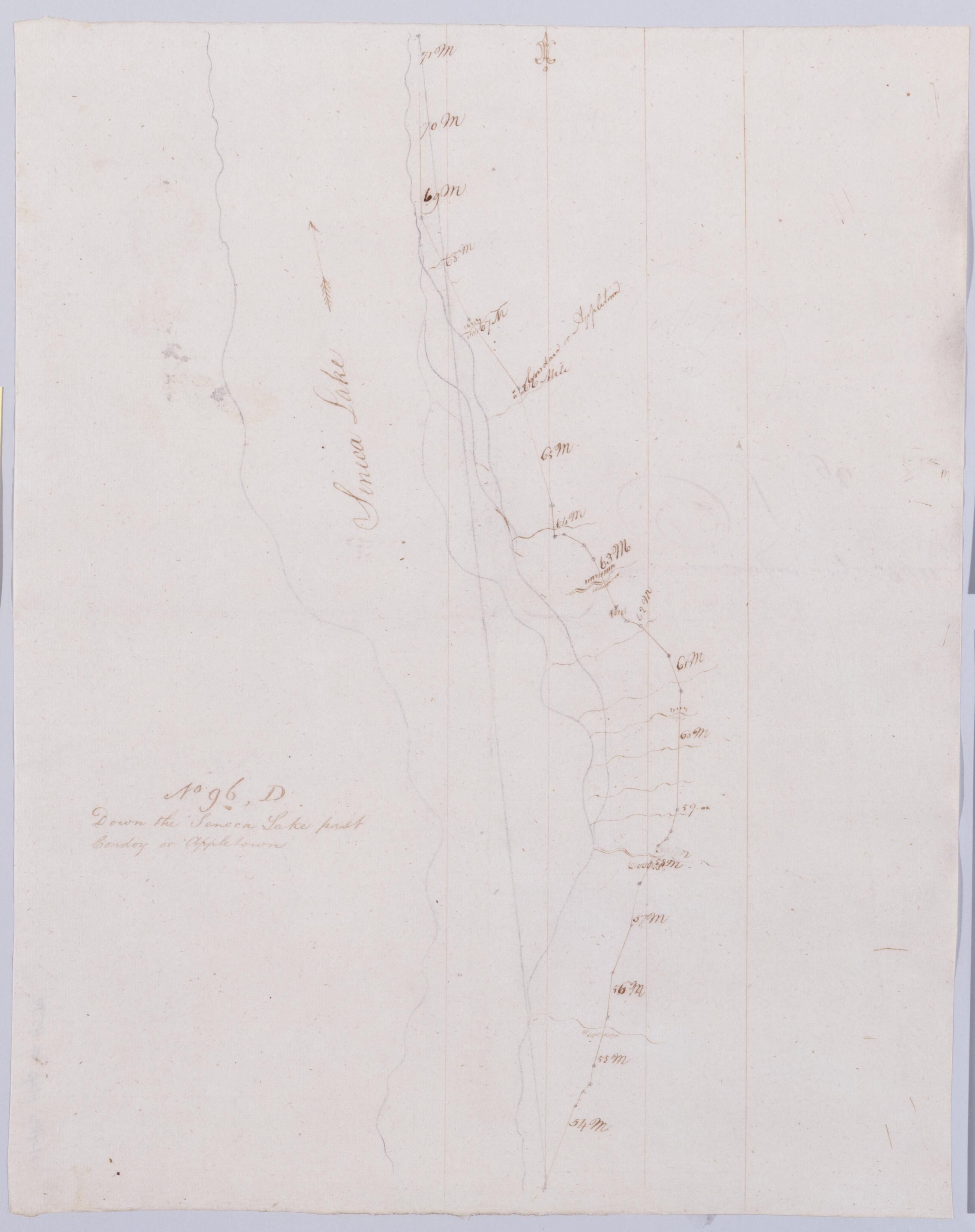
Cartographic Down the Seneca Lake past Cowdoy or Appletown. No 96, D / by Robert Erskine F.R.S. Geogr. A. U.S. and Assistants. In erased pencil on recto, "No 96 D". Military topographic map. Covers the towns of Varick, Romulus, Ovid and Lodi in Seneca County, New York. Shows roads running through Caywood and Willard. Also shows landforms and streams. Pen-and-ink, pencil on laid paper. Scale statement from verso of sheet 96,A. Shows relief by hachures. Soiled, creased and abraded. Mounted on cloth, bound, disbound and silked by subsequent owners. Cleaned after removal of backings 1999; some fill remains. Sheathed in mylar. View Item
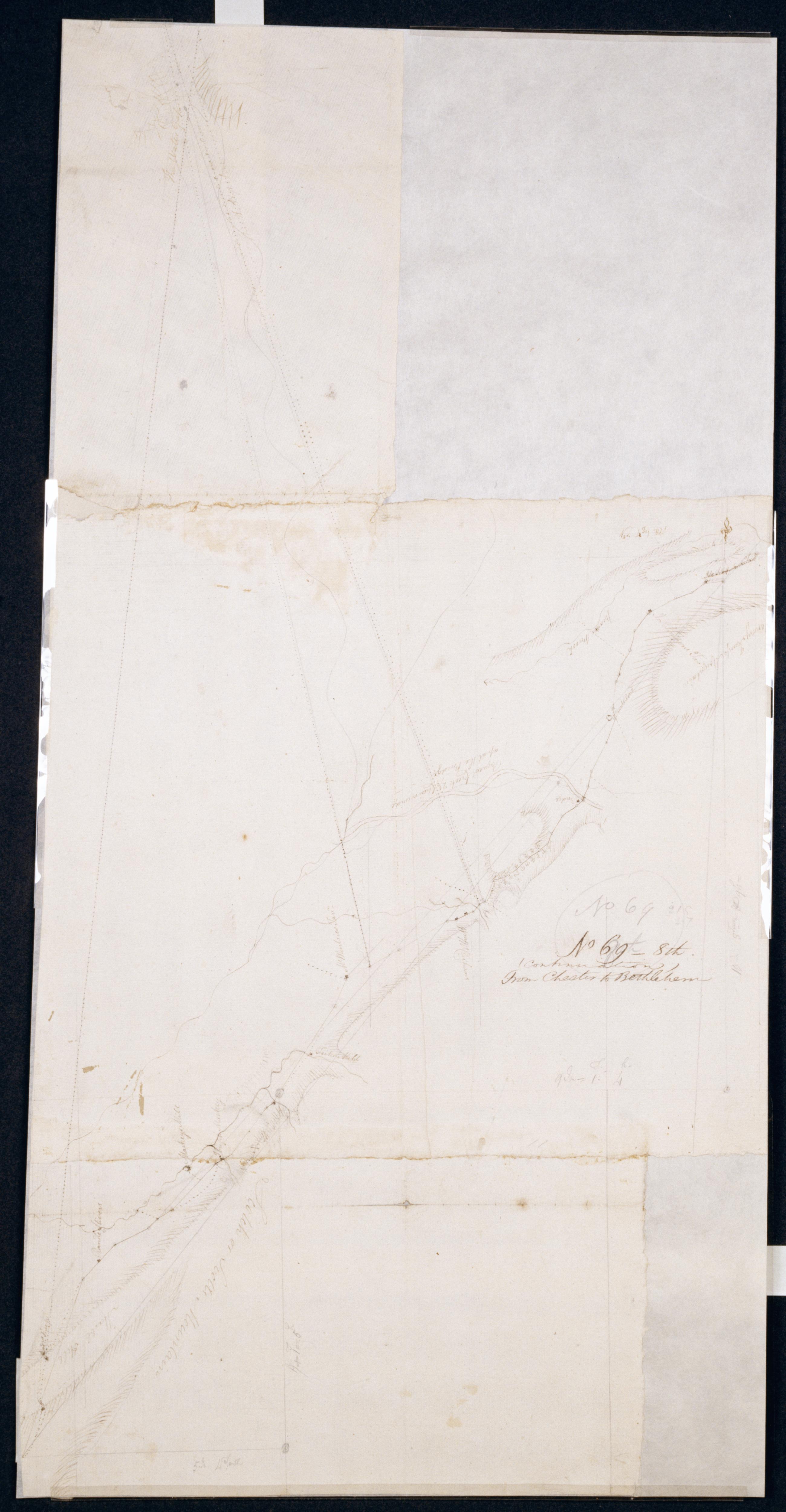
Cartographic (Continuation) From Chester to Bethlehem. No 69-8th / by Robert Erskine F.R.S. Geogr. A. U.S. and Assistants. Coordinates describe only that area of map showing the road, not the Delaware River and its watergap to north. In pencil on recto: "No 69 8th". Military topographic map. Covers the townships of Hope, Oxford and Harmony in Warren County, New Jersey. Shows roads running through Swayze Mills and Oxford Church. Also shows buildings and owners' names, landforms and streams. Pen-and-ink, pencil on laid paper. Shows relief by hachures. Stained, creased and abraded. Mounted on cloth, bound and cropped, disbound and silked by subsequent owners. View Item
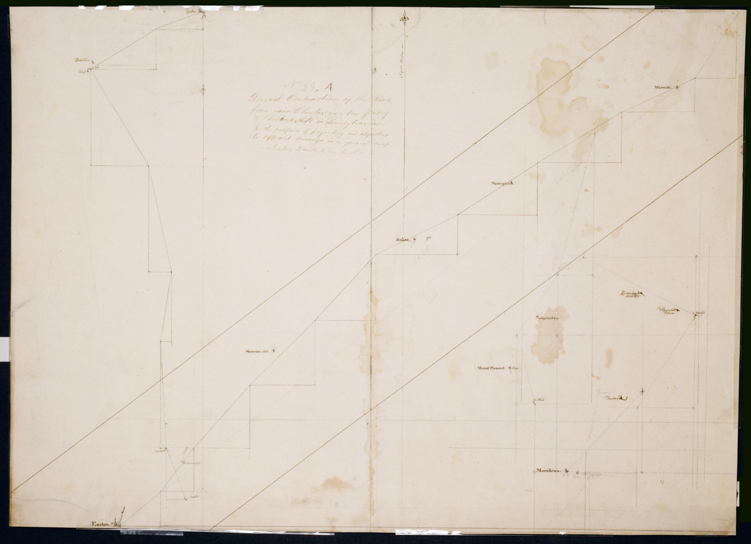
Cartographic General Contraction of the Road from near Chester in New Jersey to Chestnut Hill in Pennsylvania For the purpose of projecting and adjusting the different surveys in a general map. No 99, A / Large paper by Capt. Scull ; by Robert Erskine F.R.S. Geogr. A. In pencil on recto: "No 99 A". Military topographic map; an early draft. Lefthand segment joins center one at Easton; righthand segment continguous as drawn with center segment. Covers the counties of Northampton, Bucks and Montgomery in Pennsylvania and of Orange, Sussex, Warren, Morris and Passaic in New Jersey. Pen-and-ink, pencil on laid paper. Stained, soiled, creased, and abraded. Mounted on cloth, bound and cropped, disbound and silked by subsequent owners. Cleaned after removal of backings 1999; re-lined with China paper. Sheathed in mylar. View Item
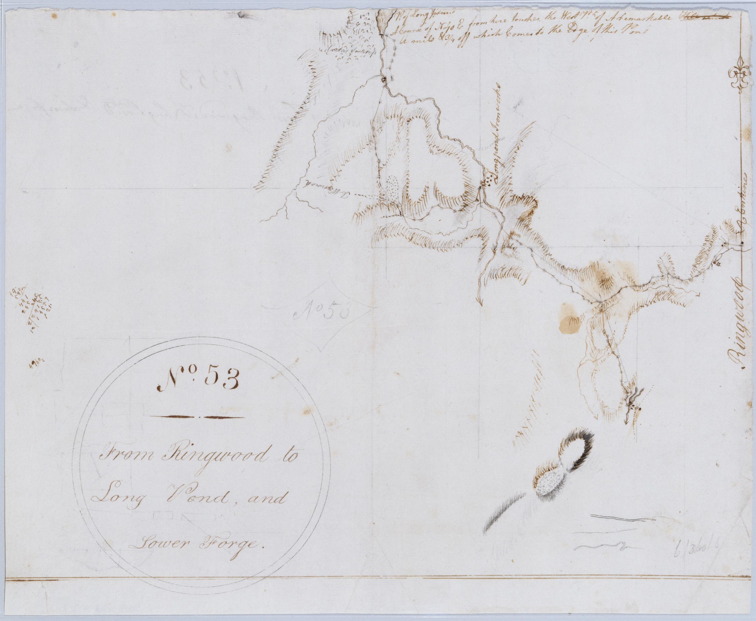
Cartographic From Ringwood to Long Pond, and Lower Forge. No. 53 / by Robert Erskine F.R.S. Geogr. A. U.S. and Assistants. Foxed, stained, frayed and abraded. Mounted on cloth, bound and cropped, disbound and silked by subsequent owners. Cleaned after removal of backings 1999; some fill remains. Sheathed in mylar. In pencil on recto: "No 53". Includes text: "P. of Long poun[d] A Course of N40 E from here touches the West Pt. of A remarkable [Hill] ... A mile & 3/4 off which Comes to the Edge of this Pond" ("Hill" and one word following it are crossed out). Military topographic map. Covers the townships of West Milford and Pompton, Passaic County, New Jersey; Long Pond is now called Greenwood Lake. View Item
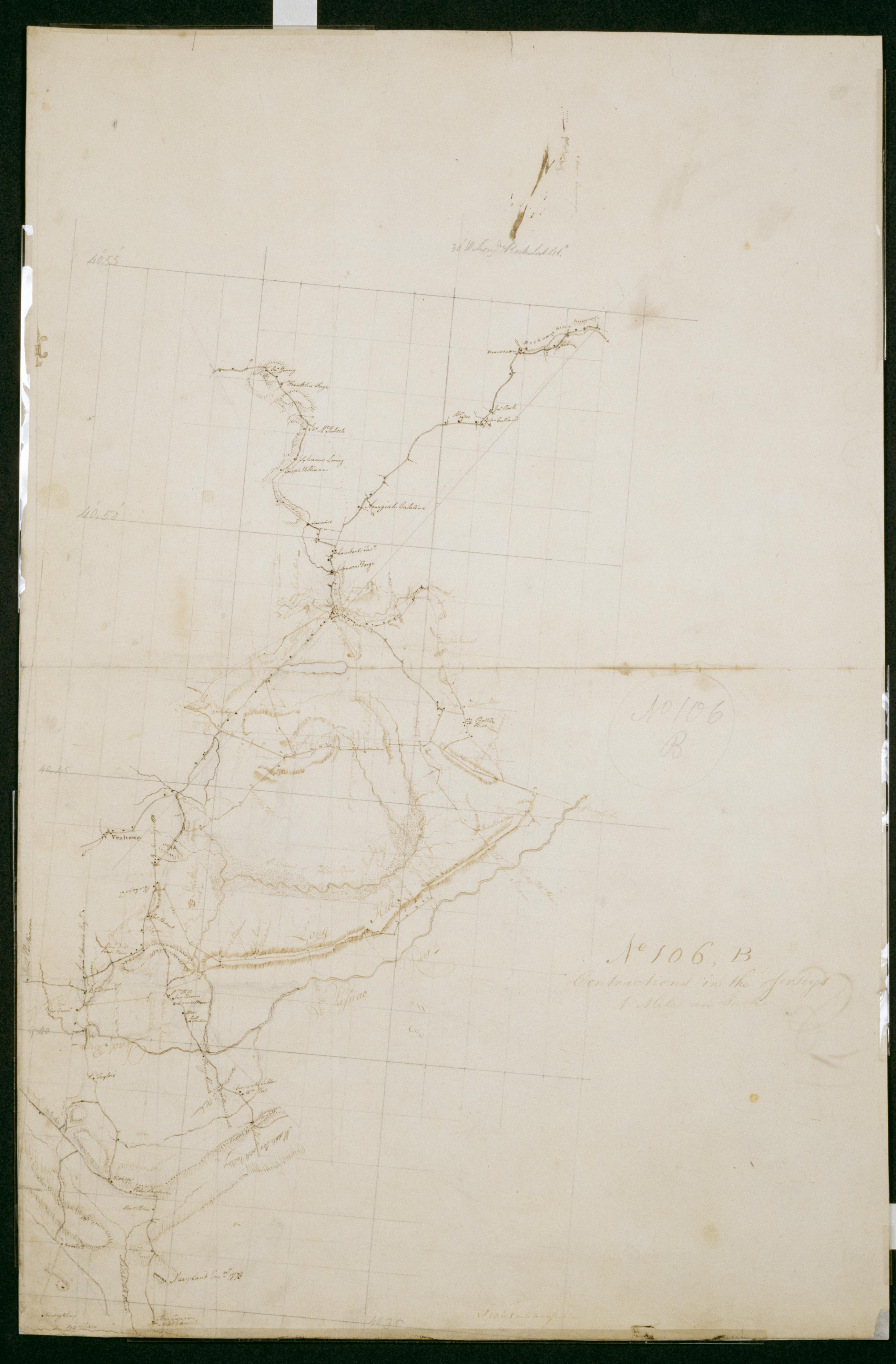
Cartographic Contractions in the Jerseys 1 Mile an Inch. No 106, B / by S. DeWitt A.B. ; by Robert Erskine F.R.S. Geogr. A. U.S. and Assistants. Imperfect: lacking 1 x 4 cm. at center of sheet. In ink on verso "No 106 B B B". In pencil on recto: "No 106 B". Military topographic map. Covers the counties of Union, Somerset and Morris in New Jersey. Shows buildings and owners' names, landforms and streams. Also shows position of "Maryland Enc[ampmen]t 1778." Pen-and-ink, pencil on laid paper. Shows relief by hachures. Stained, creased, frayed and abraded. Mounted on cloth, bound and cropped, disbound and silked by subsequent owners. Cleaned after removal of backings 1999; re-backed with China paper. Sheathed in mylar. View Item
Cartographic Road from Raway Meeting House to Westfield, from Westfield towards the Short Hills. No 75, C / by Robert Erskine F.R.S. Geogr. A. U.S. and Assistants. In pencil on recto: "No 75 C." On verso: "Good Good From Jany". Military topographic maps. Left map is an incomplete version of that on the right; right map includes bottom segment, which joins it at lower right. Map covers the townships of Westfield, Clark, Rahway and Fanwood in Union County, New Jersey. It shows roads running through Rahway and Westfield. Also shows buildings and owners' names, landforms and streams. Pen-and-ink, pencil on laid paper. Shows relief by hachures. Soiled, stained, creased and abraded. View Item
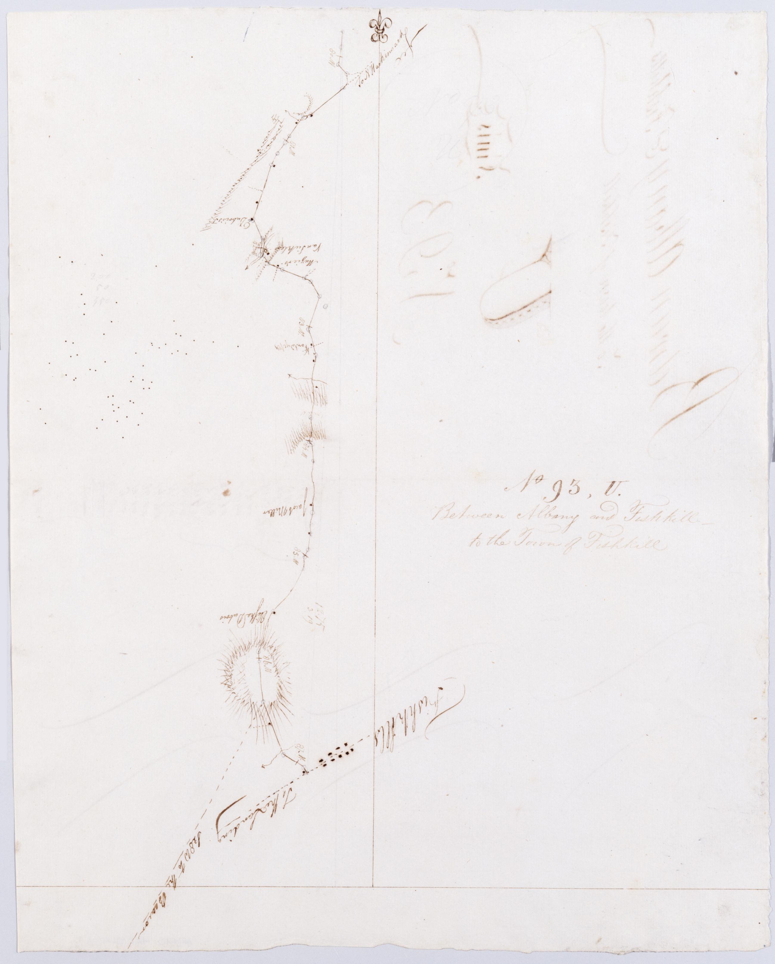
Cartographic Between Albany + Fishkill - to the Town of Fishkill. No 93, U / by Robert Erskine F.R.S. Geogr. A. U.S. and Assistants. Foxed, stained, creased and abraded. Mounted on cloth, cropped and bound, disbound and silked by subsequent owners. Cleaned after removal of backings 1999; some fill remains. Sheathed in mylar. In ink on verso: "U U U" and "Finis". In pencil on recto: "No 93 U". Military topographic map. Covers the townships of Poughkeepsie, Wappinger and Fishkill in Dutchess County, New York. Shows roads running through Channingville, Wappinger Falls and Fishkill Village. Also shows buildings and owners' names, landforms and streams. Pen-and-ink, pencil on laid paper. Shows relief by hachures. View Item
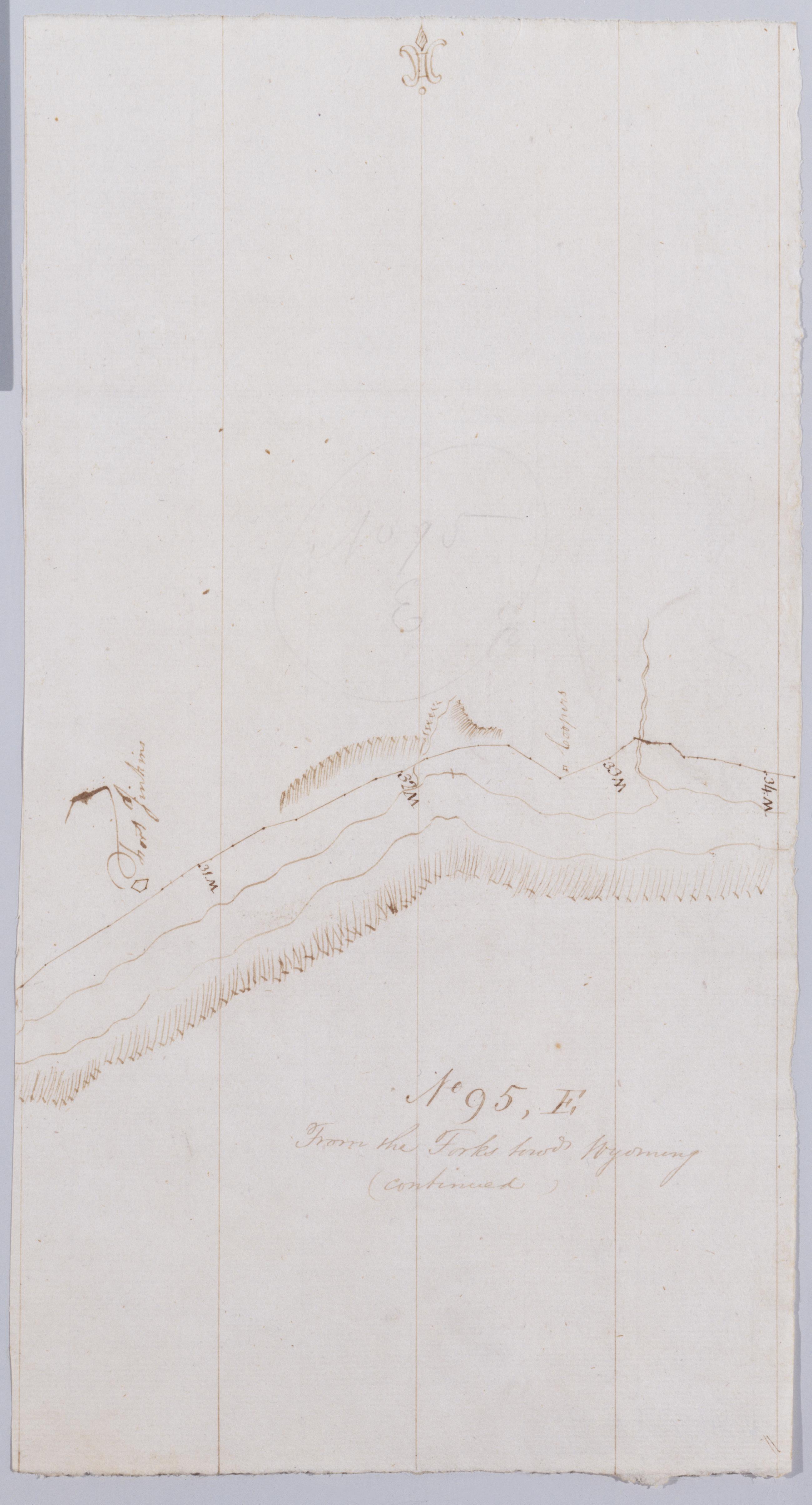
Cartographic From the Forks towds Wyoming (continued). No 95, E / by Robert Erskine F.R.S. Geogr. A. U.S. and Assistants. Creased and abraded. Mounted on cloth, cropped and bound, disbound and silked by subsequent owners. Cleaned after removal of backings 1999; some fill remains. Sheathed in mylar. In pencil on recto, "No 95 E". Military topographic map. Covers part of Columbia County in Pennsylvania. Shows roads running through Willow Springs and Lime Ridge. Also shows landforms and streams. Pen-and-ink, pencil on laid paper. Shows relief by hachures. Title proper from recto is the work of a later editor--Simeon DeWitt or his assign--subsequent to 1820. View Item
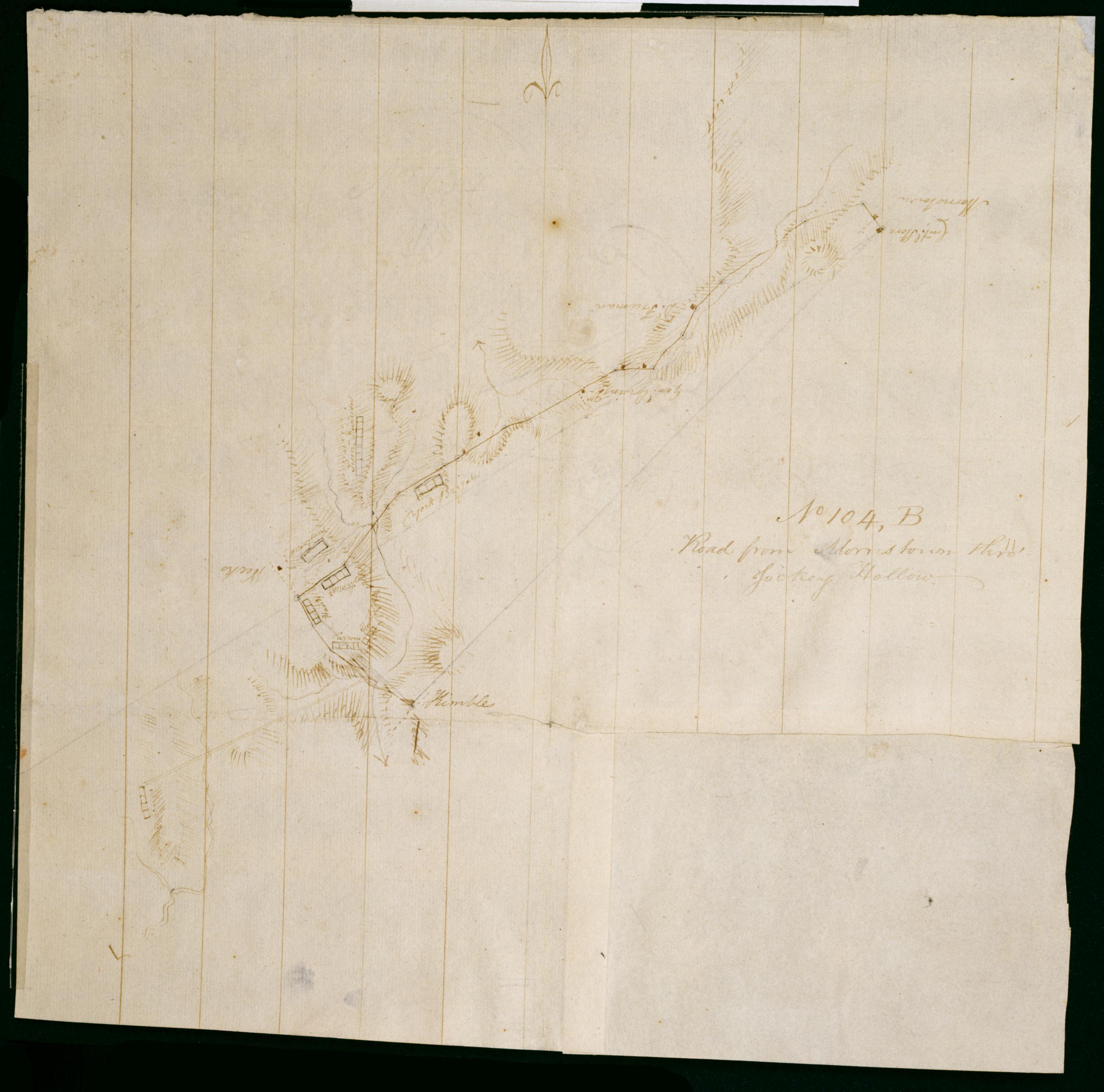
Cartographic Road from Morristown thro' Jockey Hollow. No 104, B / by Robert Erskine F.R.S. Geogr. A. U.S. and Assistants. Foxed, creased, frayed and abraded. Mounted on cloth, bound and cropped, disbound and silked by subsequent owners. Cleaned after removal of backings 1999; some fill remains. Sheathed in mylar. In erased pencil on recto: "No 104 B". Military topographic map. Covers the townships of Passaic and Morris in Morris County and of Bernard in Somerset County, New Jersey. Marks and lables troop positions at Morristown. Also shows roads, buildings and owners' names, landforms and streams. Pen-and-ink, pencil on laid paper. Patch at right corner is later, wove finish paper. Shows relief by hachures. View Item
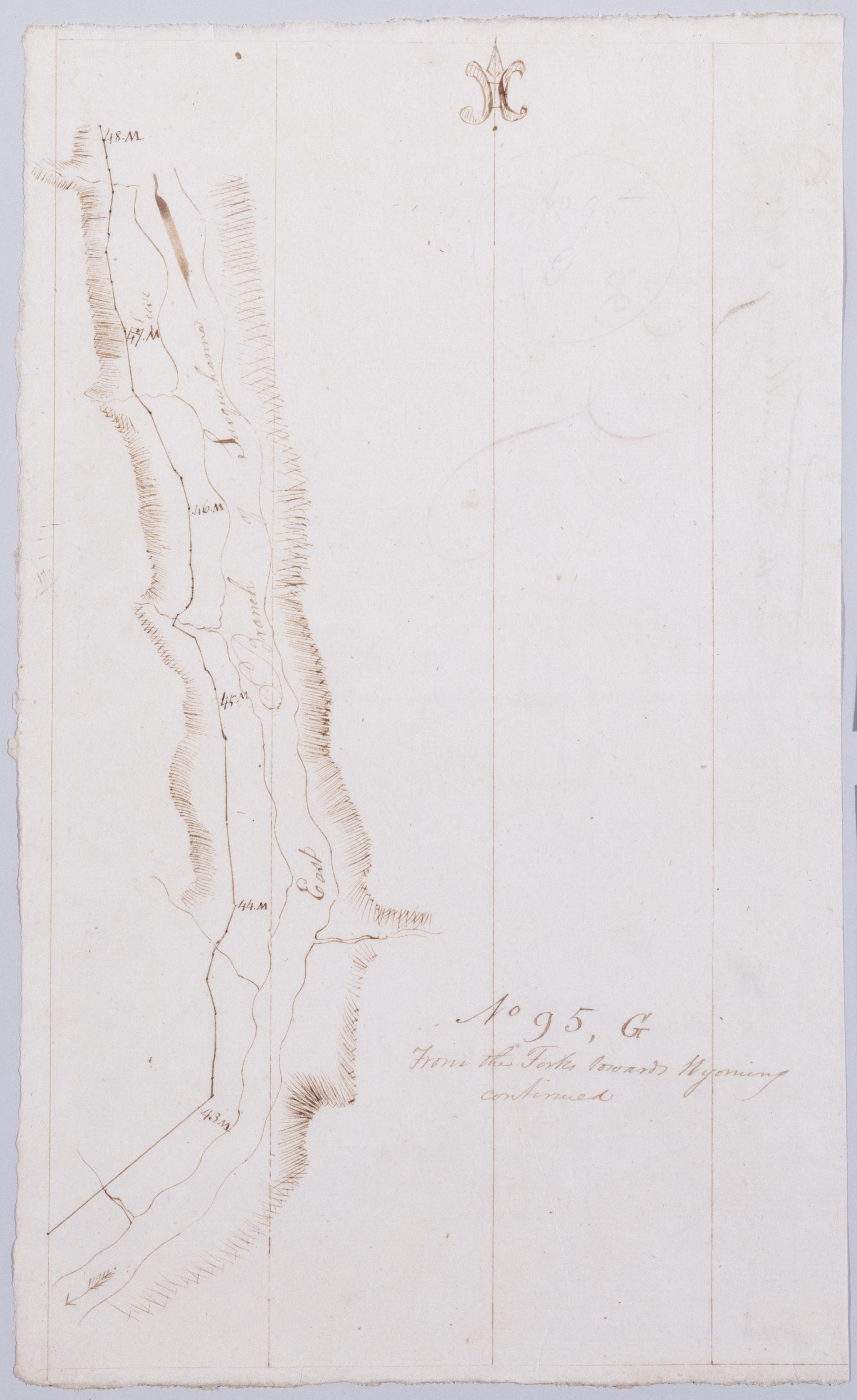
Cartographic From the Forks towards Wyoming continued. No 95, G / by Robert Erskine F.R.S. Geogr. A. U.S. and Assistants. In pencil on recto, "No 95 G". Military topographic map. Covers part of Luzerne County in Pennsylvania. Shows roads running through Wapwallopen. Also shows landforms and streams. Pen-and-ink, pencil on laid paper. Shows relief by hachures. Soiled, foxed, creased and abraded. Mounted on cloth, bound, disbound and silked by subsequent owners. Cleaned after removal of backings 1999; some fill remains. Sheathed in mylar. Title proper from recto is the work of a later editor--Simeon DeWitt or his assign--subsequent to 1820. Title from verso is in Erskine's hand and may be cited as such. View Item
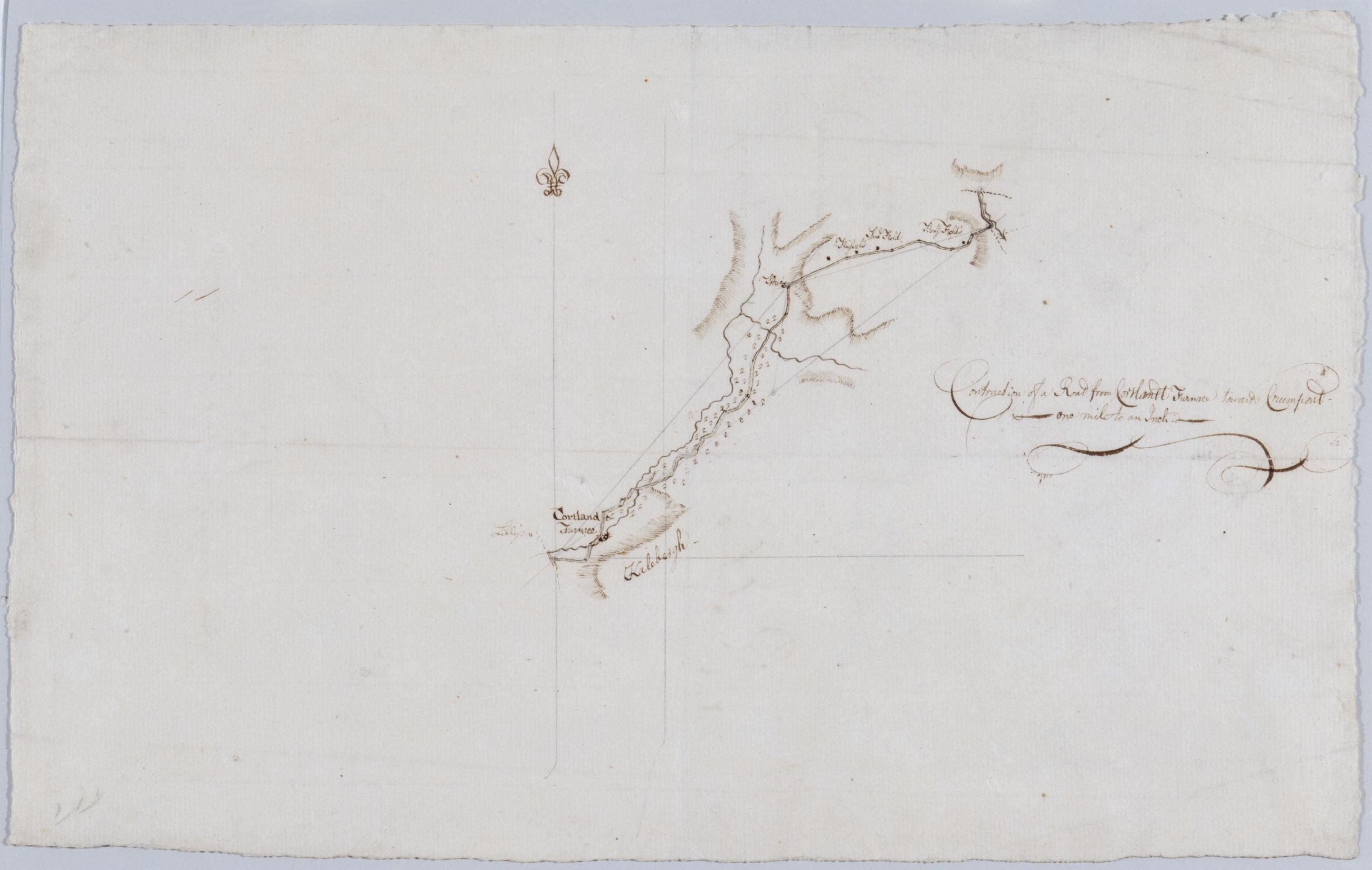
Cartographic Contraction of a Road from Cortlandt Furnace towards Crumpont / by Robert Erskine F.R.S. Geogr. A. U.S. and Assistants. Title as given by Guthorn: Contraction of a Road from Cortlandt Furnace towards Crum pond. Foxed, creased and abraded. Mounted on cloth, bound, disbound and silked by subsequent owners. Cleaned after removal of backings 1999; some fill remains. Sheathed in mylar. In ink on verso: "Belonging to No. 1" repeated twice; also "E" once. In pencil: "Should be attached to Map in DeWitt [Atlas]". Military topographic map. Covers an area SE of Peekskill, in the towns of Cortlandt and Yorktown, Westchester County, on the east bank of the Hudson River. View Item
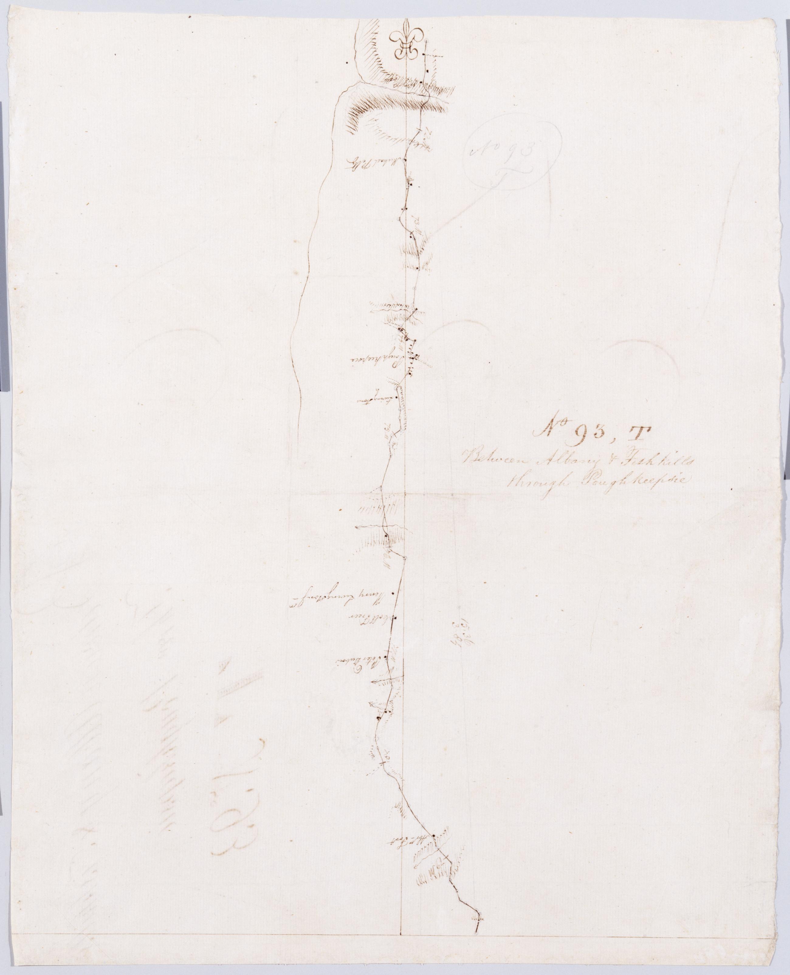
Cartographic Between Albany + Fishkills through Poughkeepsie. No 93, T / by Robert Erskine F.R.S. Geogr. A. U.S. and Assistants. Foxed, soiled, creased and abraded. Mounted on cloth, cropped and bound, disbound and silked by subsequent owners. Cleaned after removal of backings 1999; some fill remains. Sheathed in mylar. In ink on verso: "T T T". In pencil on recto: "No 93 T". Military topographic map. Covers the township of Hyde Park and Poughkeepsie in Dutchess County, New York. Shows roads running through Poughkeepsie. Also shows buildings and owners' names, landforms and streams. Pen-and-ink, pencil on laid paper. Shows relief by hachures. View Item
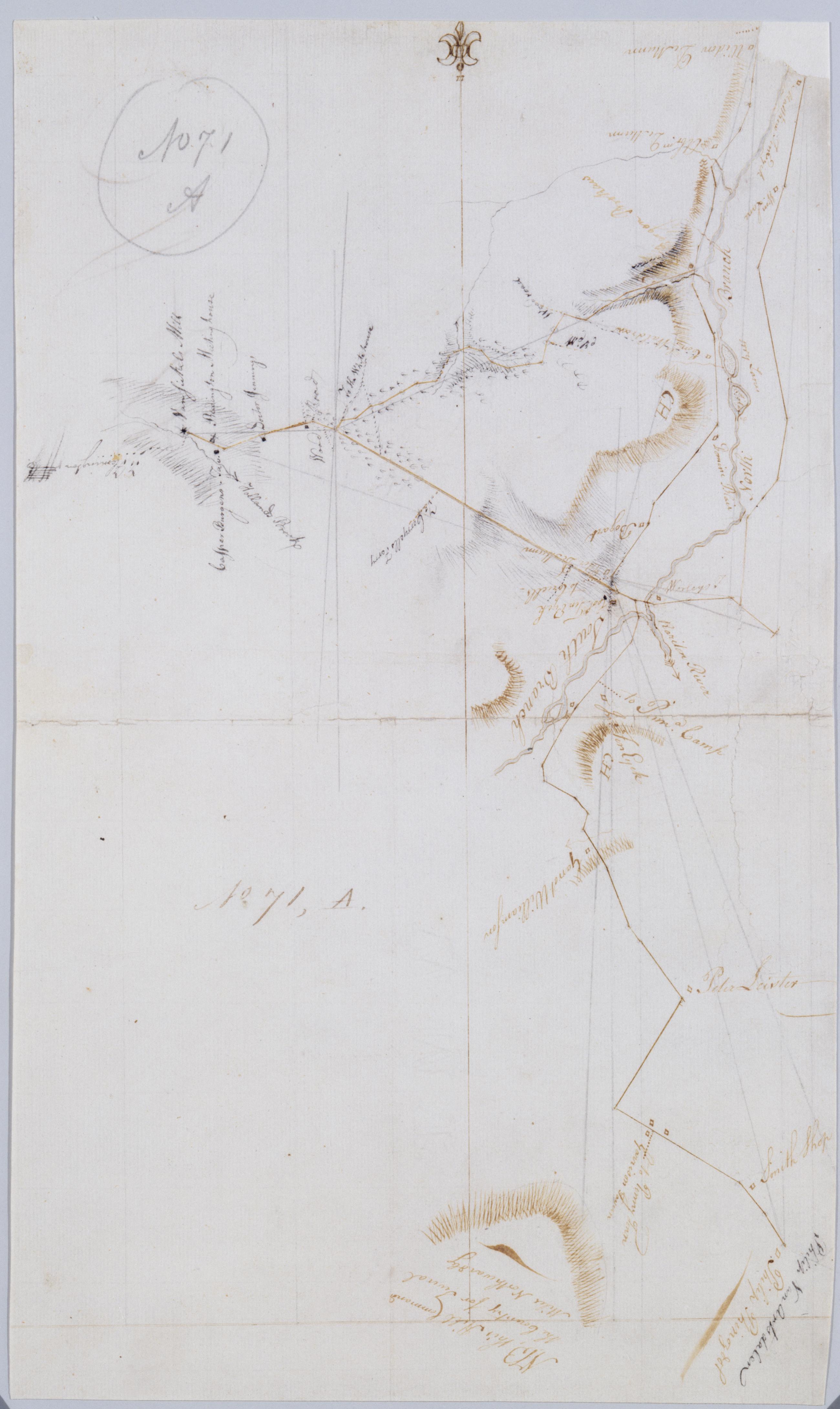
Cartographic [Garisons Somerset Boundbrook from South Branch to Reddington Brokaws] No. 71, A / by Robert Erskine F.R.S. Geogr. A. U.S. and Assistants. Foxed, creased, frayed and abraded. Mounted on cloth, bound and cropped, disbound and silked by subsequent owners. Cleaned after removal of backings 1999; some fill remains. Sheathed in mylar. In ink on verso: "A - 71". In pencil on recto "No 71 A". Military topographic map. Covers the townships of Readington and Branchburg in Hunterdon County and of Bridgewater and Hillsboro in Somerset County, New Jersey. Shows roads running through Readington, North Branch, Milltown, South Branch, Flagtown and Frankfort. Also shows buildings and owners' names, landforms and streams. View Item
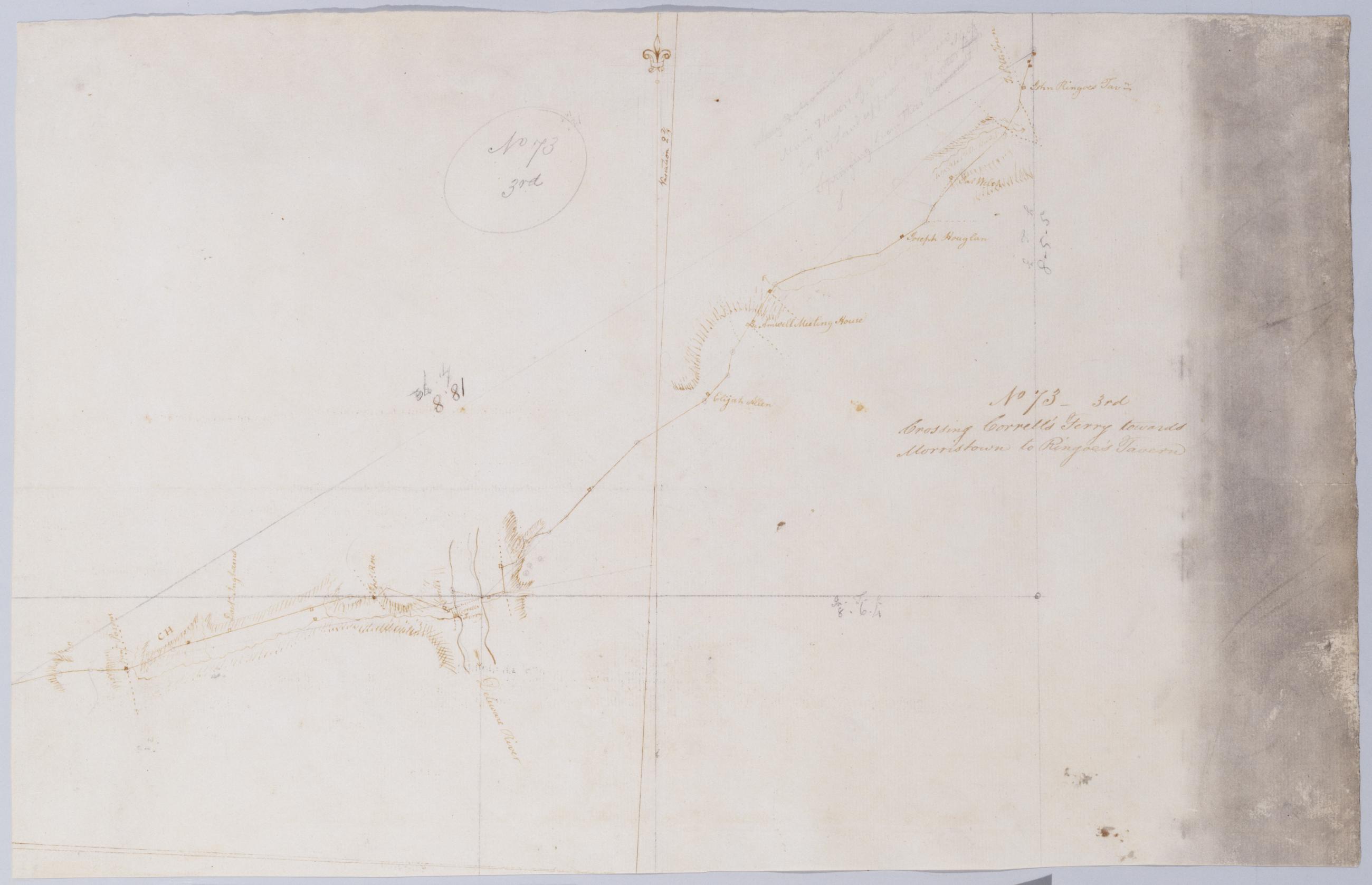
Cartographic Crossing Correll's Ferry towards Morristown to Ringoe's Tavern. No 73 - 3rd / by Robert Erskine F.R.S. Geogr. A. U.S. and Assistants. Heavily soiled, creased and abraded. Mounted on cloth, bound and cropped, disbound and silked by subsequent owners. Cleaned after removal of backings 1999; some fill remains. Sheathed in mylar. In pencil on recto: "No 73 3rd". Military topographic map. Covers the townships of Solebury in Bucks County, Pennsylvania, and of Delaware and West Amwell in Hunterdon County, New Jersey. Shows roads running through Deer Park and New Hope in Pennsylvania; Lambertville, Mount Airy and Ringoes in New Jersey. Also shows buildings and owners' names, landforms and streams. Pen-and-ink, pencil on laid paper. View Item