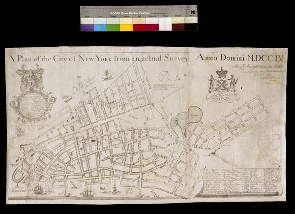
Still Image A plan of the City of New York from an actual survey anno domini MDCCLV Covers Manhattan, New York (N.Y.) below Delancey Street. Shows political divisions, fortifications, some buildings and natural features. The map also locates churches, markets, and public squares. Dedication: "To the Honourable JAMES DE LANCEY, Esqr, Lieutenant Governor and Commander In Chief In and over the Province of NEW YORK and territories depending thereon In America This Plan of the City of NEW YORK Is Humbly dedicd. By your Honours Most Obet. & Humble Servent G. View Item
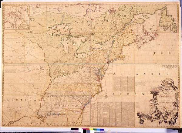
Still Image A map of the British and French dominions in North America : with the roads, distances, limits, and extent of the settlements, humbly inscribed to the Right Honourable the Earl of Halifax, and the other Right Honourable the Lords Commissioners for Trade & First impression of third edition, 1773, with hand-drawn red lines. Engraving, hand-colored. First published in 1755, John Mitchell's map was the most impressive and accurate cartographic description of Britain's territorial holdings in North America at the time. The historical significance of the map increased exponentially when it was used to demarcate potential boundaries during the negotiations of the Treaty of Paris, 1782–1783. Representatives from Britain, the United States of America, and Spain each brought a copy of the Mitchell map to the negotiations. View Item
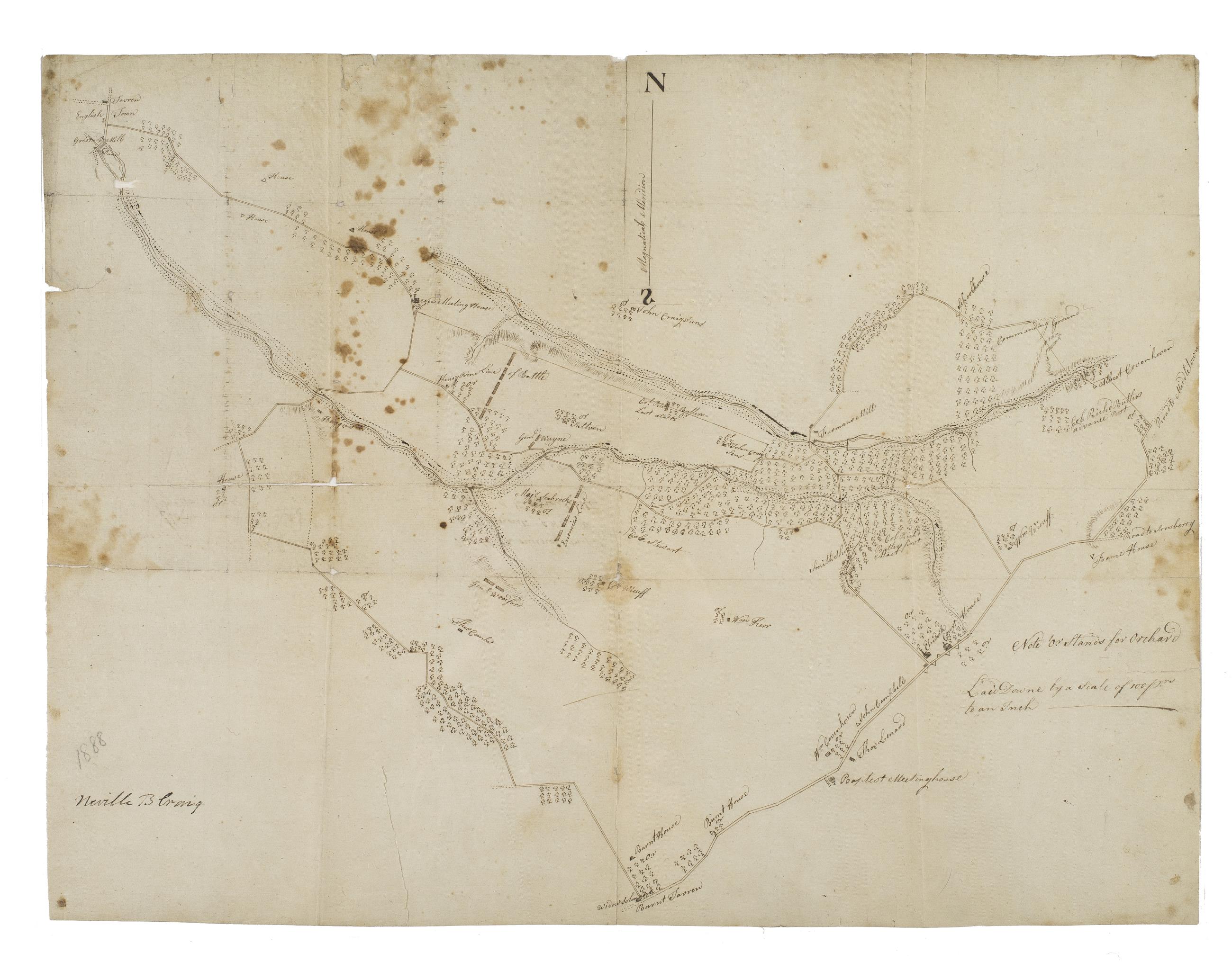
Still Image Plan of the battle of Monmouth, 28th of June, 78 Military map. Covers an area near Freehold, Monmouth County, New Jersey. Shows troop positions, commanders' names, points of attack. Also shows relief by hachures and roads, streams, buildings and vegetative cover. Title from verso text. Attributed to Butler, based on verso text in another hand: "This is an original Map of Monmouth among the papers of Richard [Butler] [B.]G. lent me by [N.B.] Cra[ig]. W.[B.R.]"--cf. American National Biography article on Butler, which names Craig his editor. Pen-and-ink on paper. Split along fold lines, strongly foxed; silked. View Item
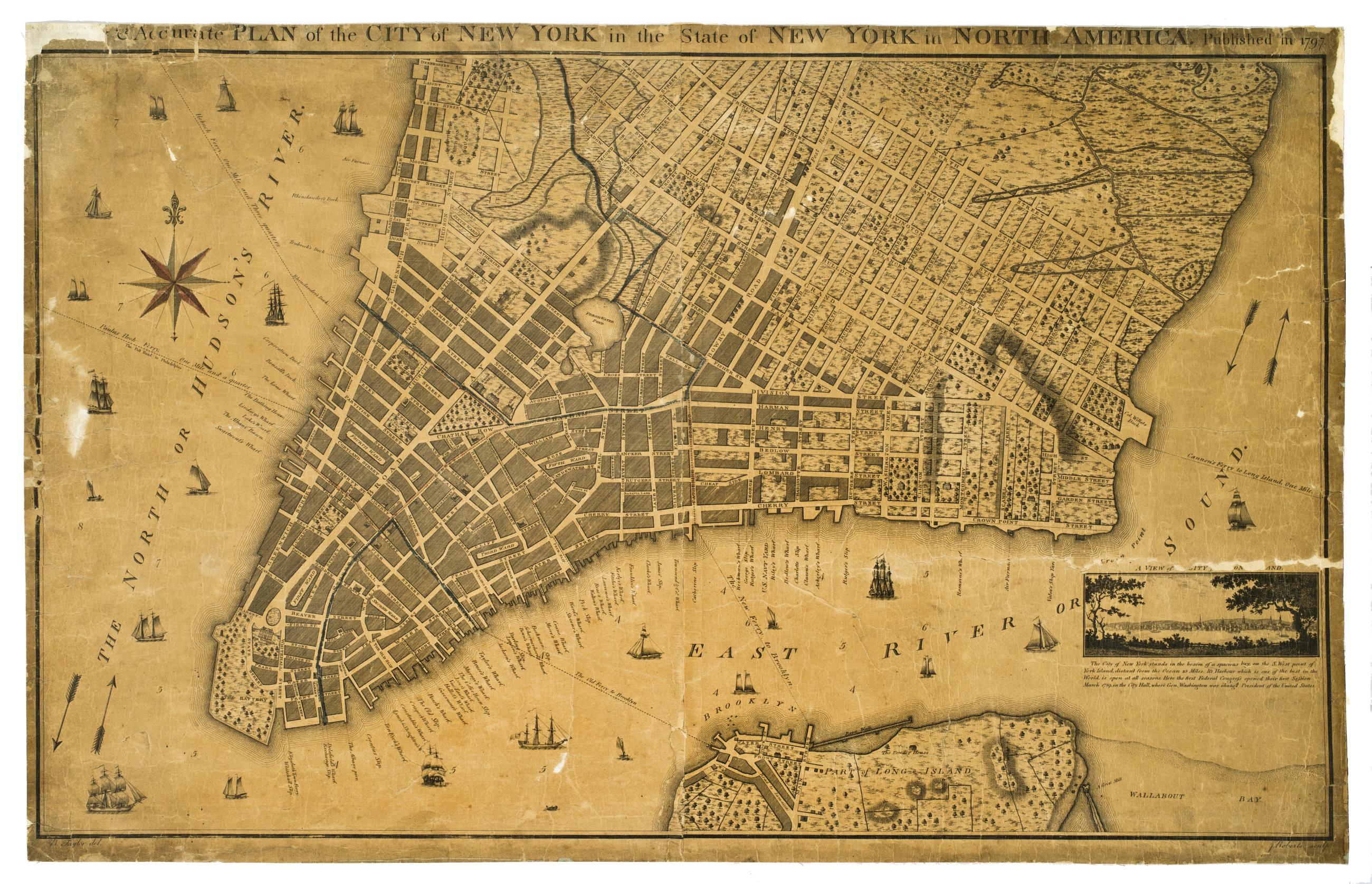
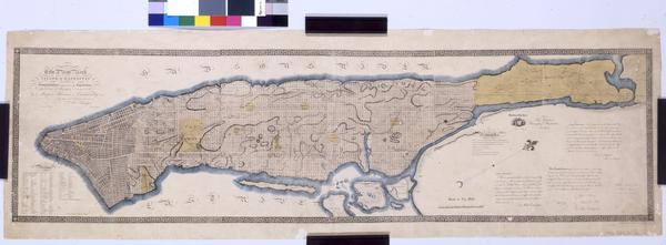
Still Image A new & accurate plan of the city of New York in the state of New York in North America Relief shown by hachures. Depths shown by soundings. Shows wards, streets, wharves, buildings, and ferry routes with distances. Ward names highlighted in pink. Described in I.N.P. Stokes' Iconography of Manhattan Island, I, pl. 64, p. 442. Inset at lower right: A view of the city from Long Island. Below inset is a brief geographical description of New York. Includes note. View Item
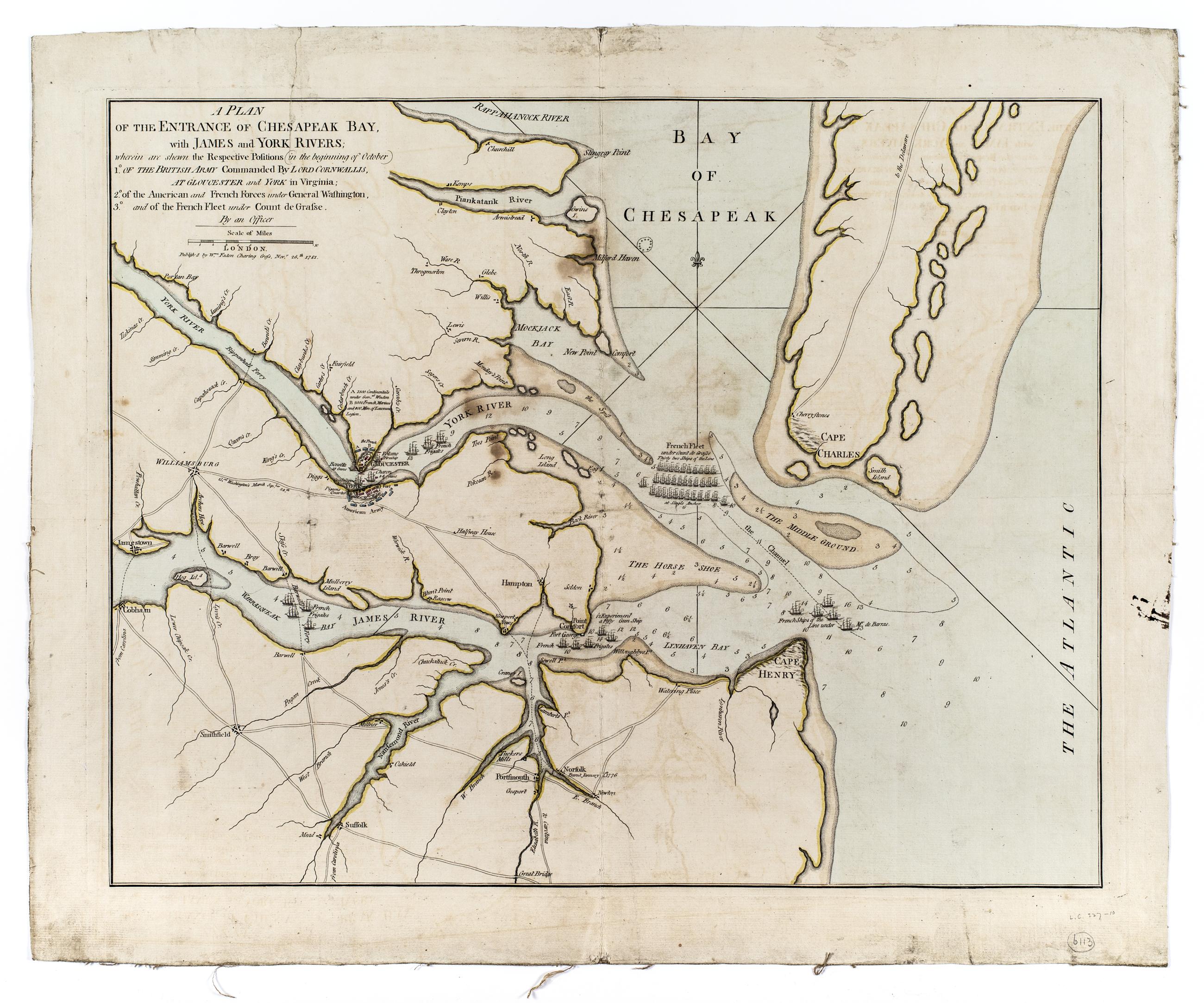
Still Image A plan of the entrance of Chesapeak Bay, with James and York Rivers; : wherein are shown the respective positions (in the beginning of October) 1° of the British army commanded by Lord Cornwallis, at Gloucester and York in Virginia; : 2° of the American a Shows James River peninsula and general positions of armies and the French fleet. N-YHS copy has a printed clipping mounted on verso, dated March 4, 1812, giving the names of vessels in the French Navy. View Item
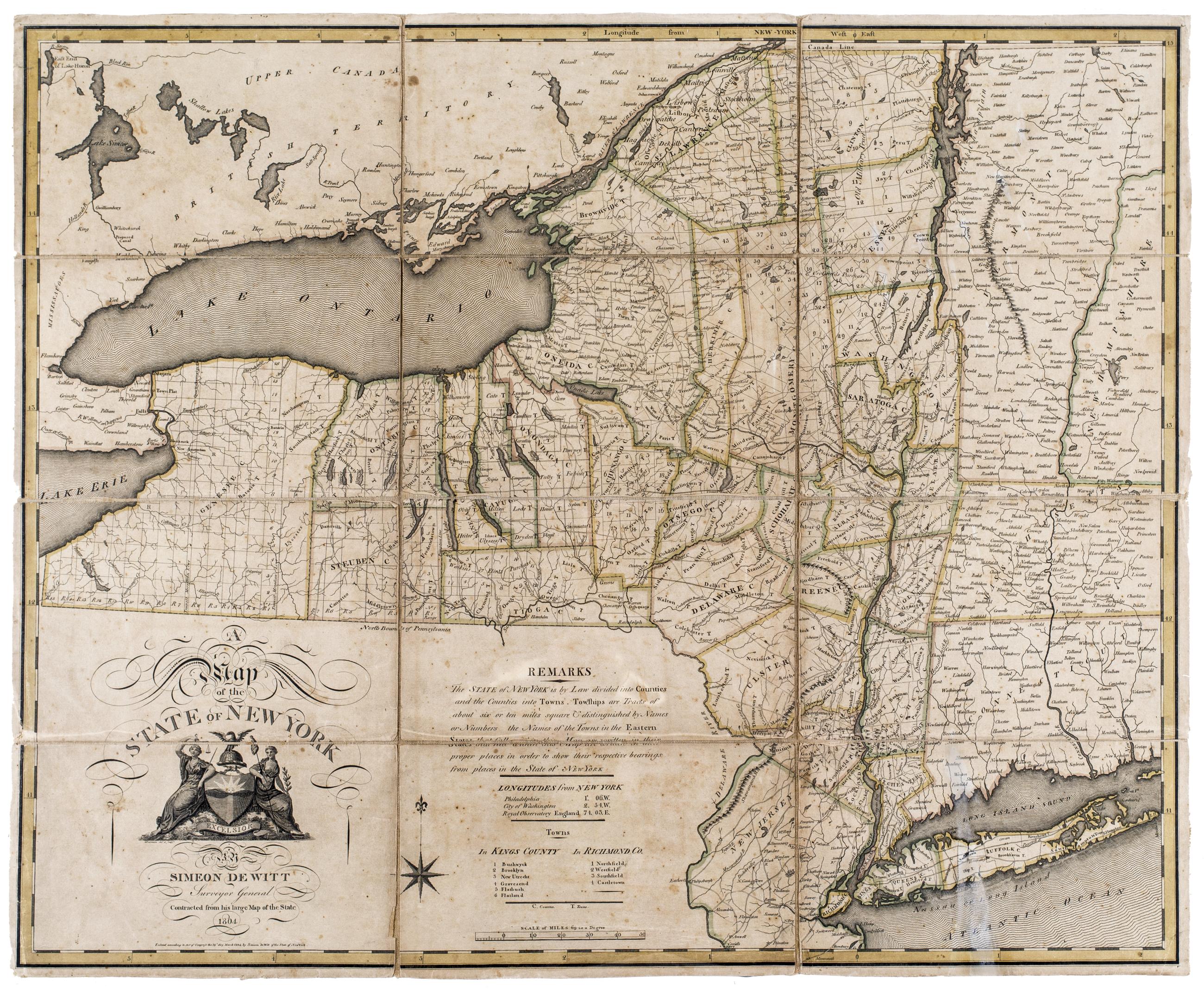
Still Image A map of the state of New York "Contracted from his large map of the state." "Entered according to Act of Congress the 19th day March 1804 by Simeon DeWitt of the state of New York." Includes text, decorative cartouche, longitudes from New York, and index to towns in Kings and Richmond counties. Relief shown pictorially. Shows county and town boundaries. Available also through the Library of Congress Web site as a raster image. View Item
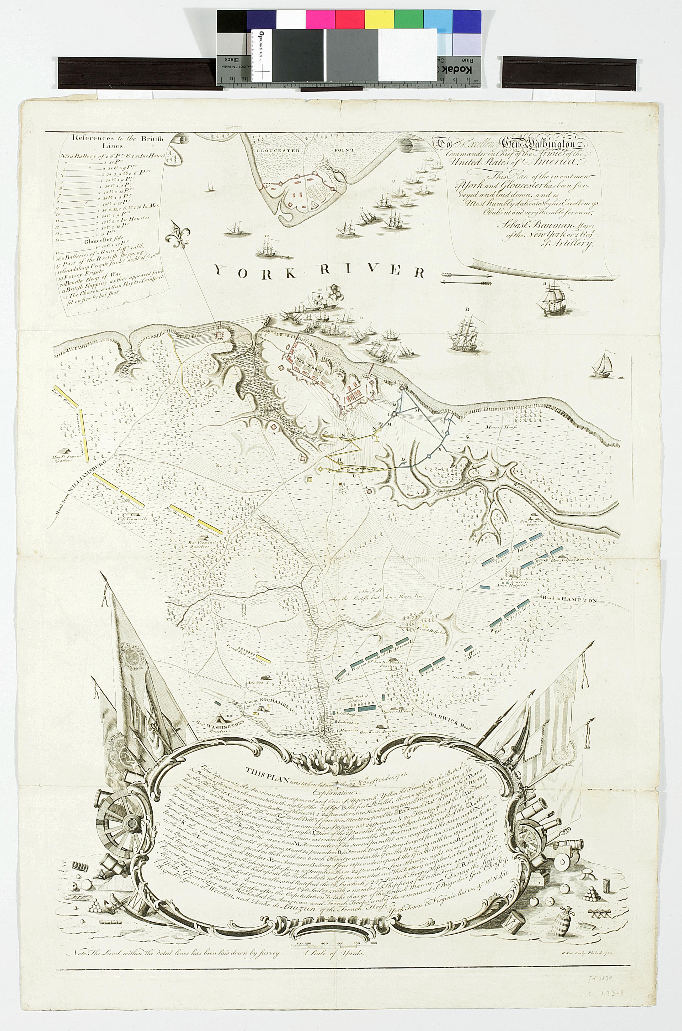
Still Image To His Excellency Genl. Washington, Commander in Chief of the armies of the United States of America : this plan of the investment of York and Gloucester has been surveyed and laid down, and is most humbly dedicated by His Excellency's obedient servant "This plan was taken between the 22nd & 28th of October, 1781."-- cartouche at foot. "Note. The Land within the doted [sic] lines has been laid down by survey." Relief shown by hachures. View Item
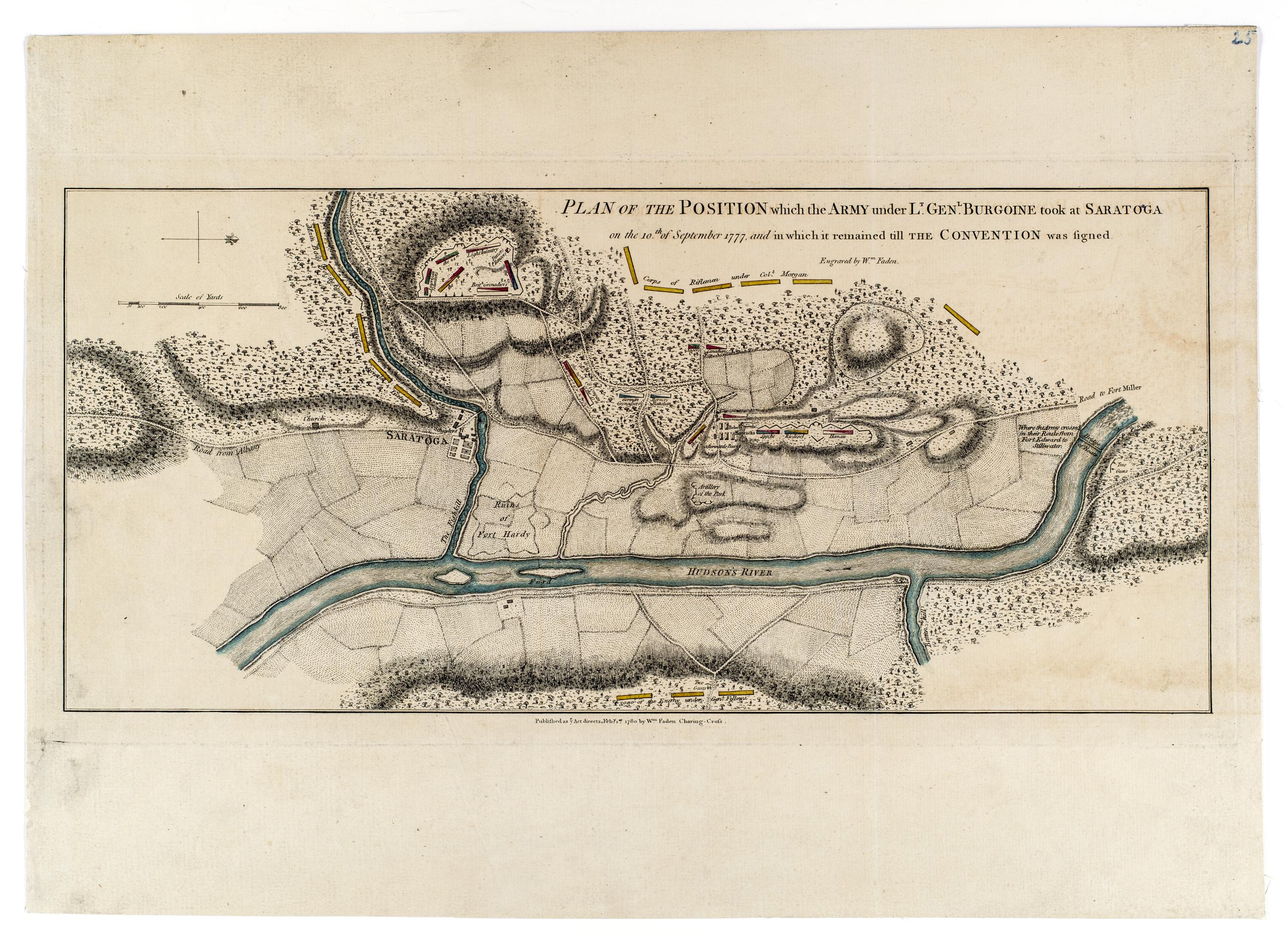
Still Image Plan of the position which the army under Lt. Genl. Burgoine took at Saratoga on the 10th of September, 1777, and in which it remained till the Convention was signed Shows deployment of armies; roads, rivers, forests, fields and camps. Relief shown by hachures and shading. Oriented with north to the right. Hand colored. View Item
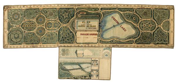
Still Image Plan of the Central Park, New York : entry no. 4 in the competition. March 20, 1858 The John Rink plan of Central Park. Number 4 of thirty-three submissions for the design competition for Central Park in Manhattan. It shows reservoirs, a parade ground, roads, plantings, and a monumental museum building (precursor of the Metropolitan Museum of Art) proposed for the south and east flanks of the Yorkville Reservoir. The plan is oriented with north to right of sheet. Ink and colored washes. References: Heckscher, M.H. Creating Central Park, p. 22. Rink was probably an engineer in the employ of the parks commissioners. View Item
Still Image Plan of the Central Park : respectfully submitted to the Commissioners of the Park : March, 1858 : A.H.N. The George E. Waring, Jr. plan of Central Park. Number 29 of thirty-three submissions for the design competition for Central Park in Manhattan. It shows reservoirs, roads, plantings, a "Gymnasium and Drill Room" [arsenal], and a home for the Crystal Palace. Inscription on verso: "#29 of 33 plans submitted for competition, April 1858. Edw Selo Draughtsman, G.E. Waring author". The plan is oriented with north to right of sheet. Ink and colored washes. References: Heckscher, M.H. Creating Central Park, p. 23. View Item
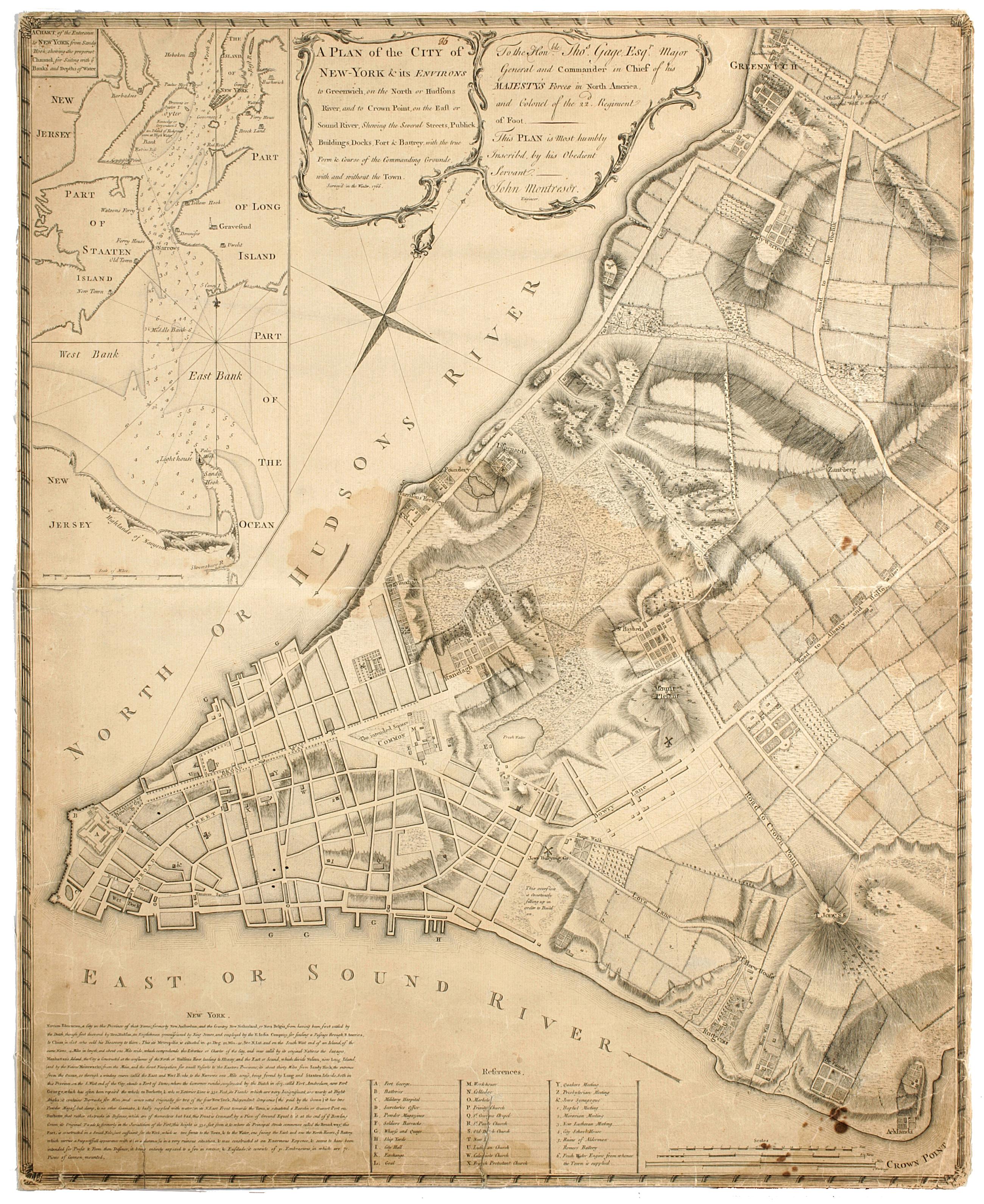
Still Image A plan of the city of New-York & its environs to Greenwich, : on the North or Hudsons River, and to Crown Point, on the East or Sound River, shewing the several streets, publick buildings, docks, fort & battery, with the true form & course of the commandi Cadastral map. Covers Manhattan, New York (N.Y.) south of the later Houston Street. Shows existing streets, some buildings, farms, docks, and names of property owners and natural landmarks. Relief shown by hachures. Black ink on paper backed with cloth. Includes text, index to points of interest, and inset "A chart of the entrance to New York from Sandy Hook, shewing the properest channel for sailing, with ye banks and depths of water," ca. 1:128,000. References: Stokes, Issac Newton Phelps. Iconography of Manhattan Island. View Item
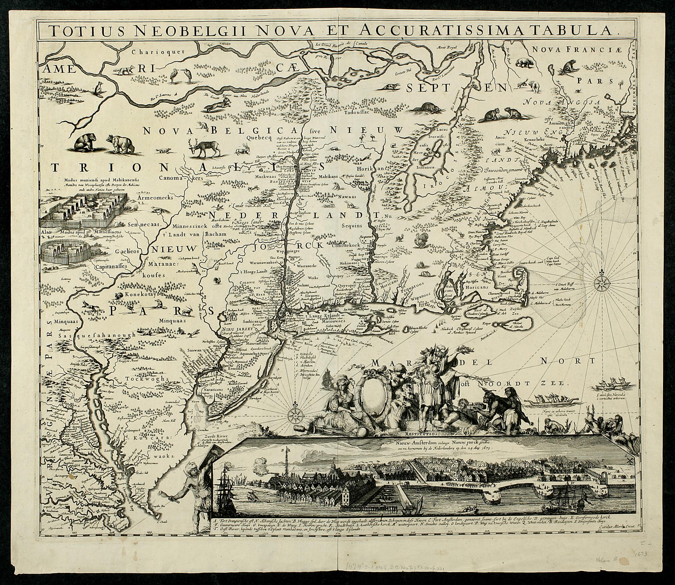
Still Image Totius Neobelgii nova et accuratissima tabula This map's image is a virtual duplicate of Joannes Jansson's "Belgii Novi Angliae," circa 1660, and some believe there was a common (Danckers) prototype. This map, of which only a few copies are known, is quite similar to the Visscher map with the most important difference being in the inset view of New York. The Allard view is a new engraving – the fifth in the sequence of engraved views of New York – made from a new drawing. When translated into English the caption identifies the view as "of New-Amsterdam lately called New York, and now retaken by the Netherlands on 14 Aug. View Item
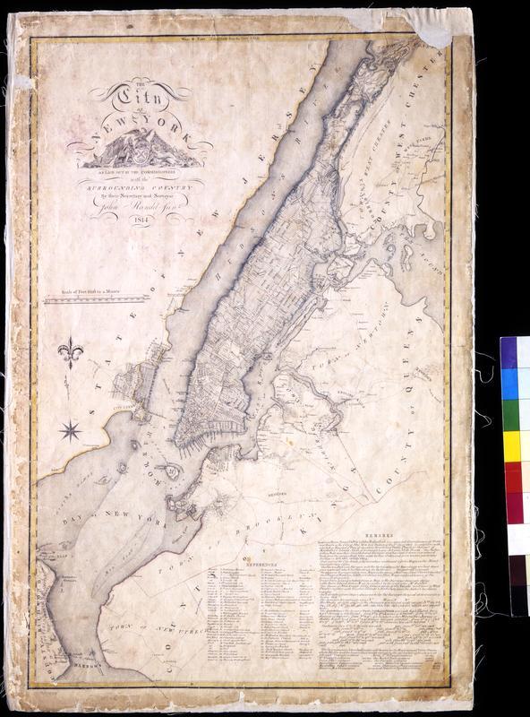
Still Image The City of New York as laid out by the Commissioners with the surrounding country / by their secretary and surveyor John Randel, Junr. Street planning map. Covers all of Manhattan Island (New York, N.Y.) and substantial parts of adjacent counties in New York and New Jersey. Shows existing and proposed streets; also buildings and other structures, streams and other wetlands, political boundaries. Includes extensive "REMARKS," also a key to New York City buildings. Pen-and-ink, watercolor on paper. Shows relief by hachures. Imperfect: lacking 4 x 9 and 2 x 5 cm. upper right corner, 2 x 2 cm. upper left side. References: Cohen, Paul E. and Robert T. Augustyn. Manhattan in Maps. NY: Rizzoli, 1997, p. 106ff; Stokes, I.N. Phelps. View Item
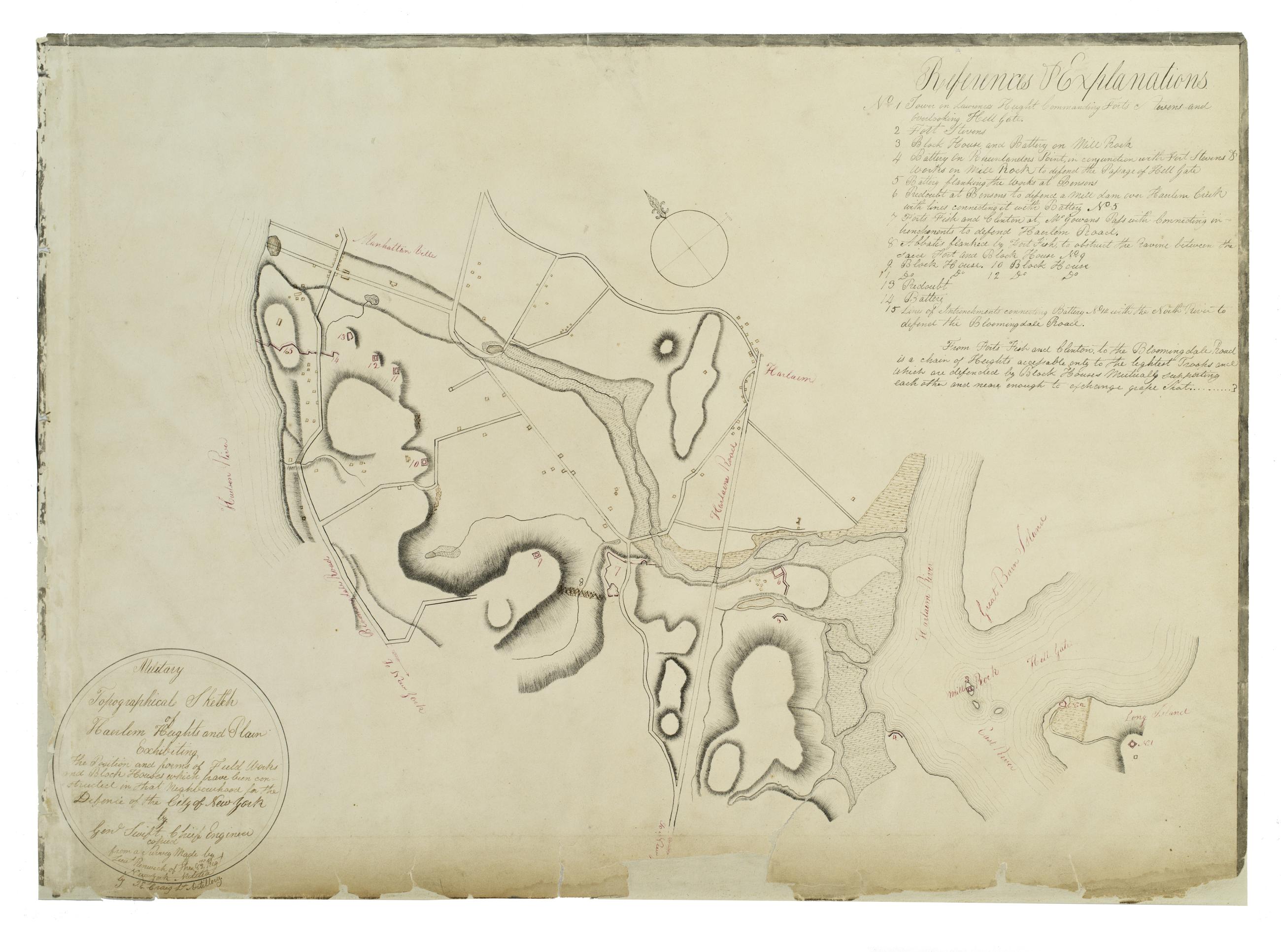
Still Image Military topographical sketch of Haerlem Heights and plain, exhibiting the position and forms of field works and block houses which have been constructed in that neghbourhood for the defence of the City of New York by Gen'l Swift, Chief Engineer / copied This manuscript map of Harlem is thought to have been drawn under the direction of James Renwick, whose son and namesake became a famous architect, for the Committee of Defense during the War of 1812. It includes a view of the Hudson River in the inset at the upper right. Military map. Covers the area later bounded by 85th and 135th Streets, Hell Gate and the Hudson River, Manhattan, New York (N.Y.). Shows fortifications, including batteries and redoubts. Also shows buildings, roads, streams and bridges. Relief shown by hachures, depths shown by form lines. View Item
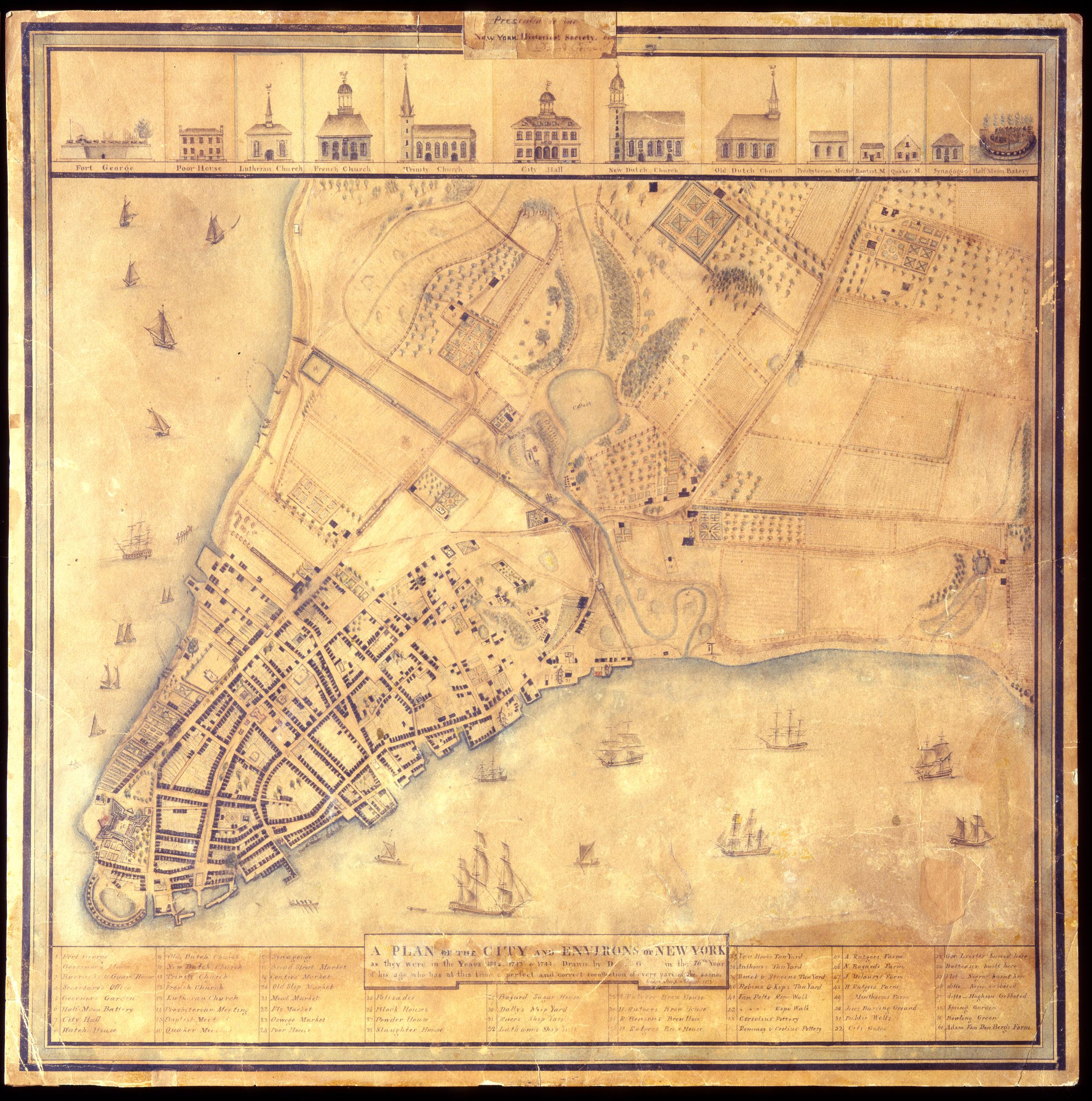
Still Image A Plan of the city and environs of New York as they were in the years 1742. 1743. & 1744. / drawn by D--- G--- in the 76th year of his age, who has at this time a perfect and correct recollection of every part of the same. Cedar Street. August 1813. David Grim's map of prerevolutionary Manhattan. Historical map. Covers Manhattan Island south of modern 14th Street, New York (N.Y.). Shows buildings and many other urban features; also shows natural and agricultural features. Date of ms. 1813 Aug. Date of situation between 1742 and 1744. On label pasted at top center: "Presented to the New York Historical Society by David Grim". Pen-and-ink (black and color), watercolor, pencil on paper. Selected material shown pictorially. Includes index. References: Cohen, Paul E. and Robert T. Augustyn. Manhattan in Maps, p. 62-63; Stokes, I.N. Phelps. View Item
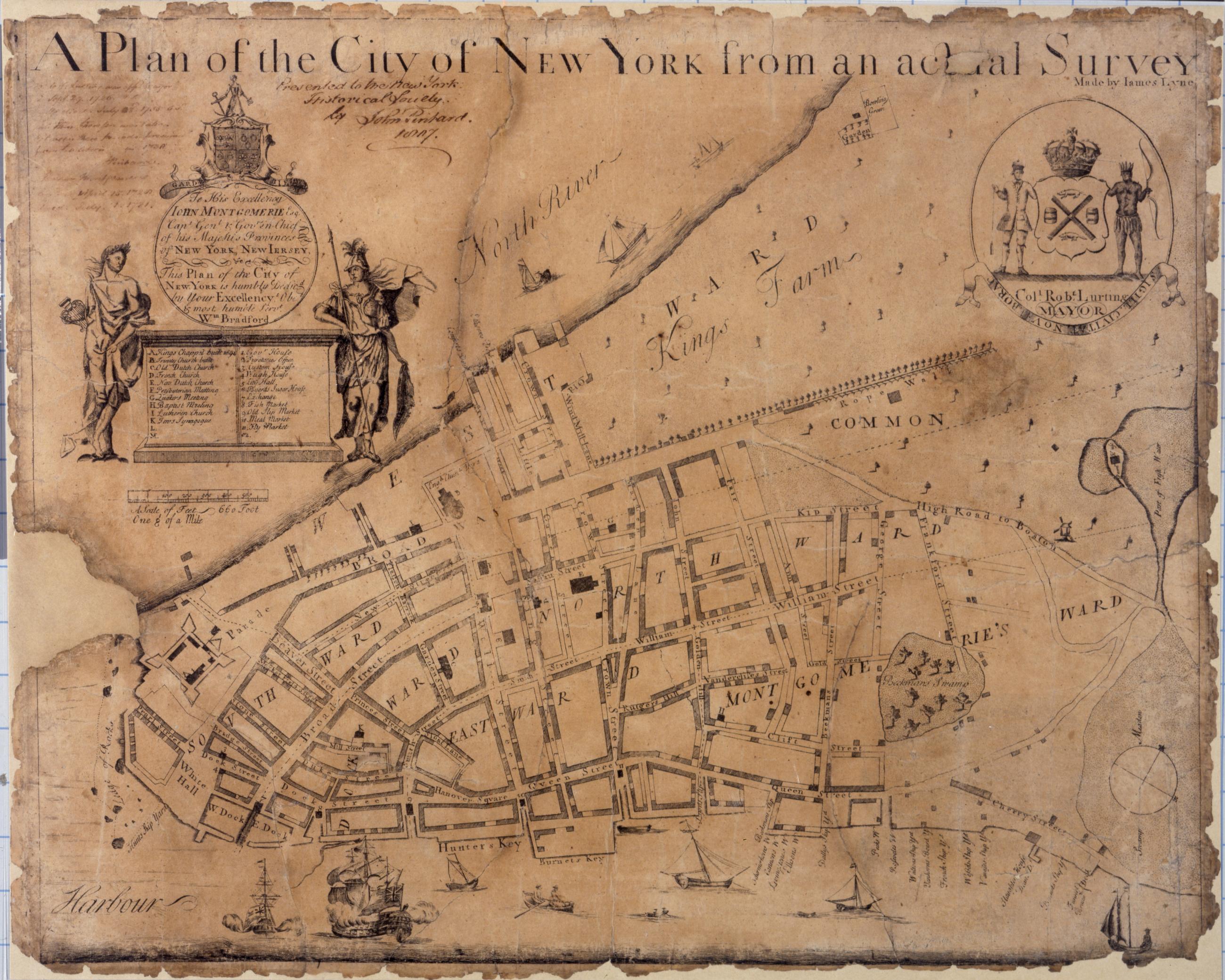
Still Image A plan of the city of New York from an actual survey, made by James Lyne Known as the Bradford map, this is the first map of New York printed in the city itself. It is dated to 1731 on the basis of an advertisement in the New York Gazette, August 30-September 6, 1731. Covers lower Manhattan. Shows wards, streets, and public buildings. Oriented with north toward the upper right. Includes index to points of interest. In cartouche at upper left: "To his excellency John Montgomerie, Esq. Capt. Genl. & Gov. View Item
Still Image This map of the City of New York and island of Manhattan as laid out by the commissioners appointed by the legislature April 3, 1807 is respectfully dedicated to the mayor, alderman and commonality thereof / by their most obedient servant Wm. Bridges ; en Photolithographic reproduction of the William Bridges map of New York. Street planning map. Covers the entire island of Manhattan, New York (N.Y.) Shows some buildings. Also shows landforms and streams. Shows relief by shading. Derived from a manuscript draft by John Randel--cf. Cohen and Augustyn, op. cit. "Filed April 1st 1811." Certified by the commissioners. Ink, color wash. No watermark. Includes index. References: I.N.P. Stokes, Iconography of Manhattan Island (1915-1928), Vol. III, page 549; Daniel C. Haskell, Manhattan Maps (1931), 655; Cohen, Paul E. and Robert T. Augustyn. View Item
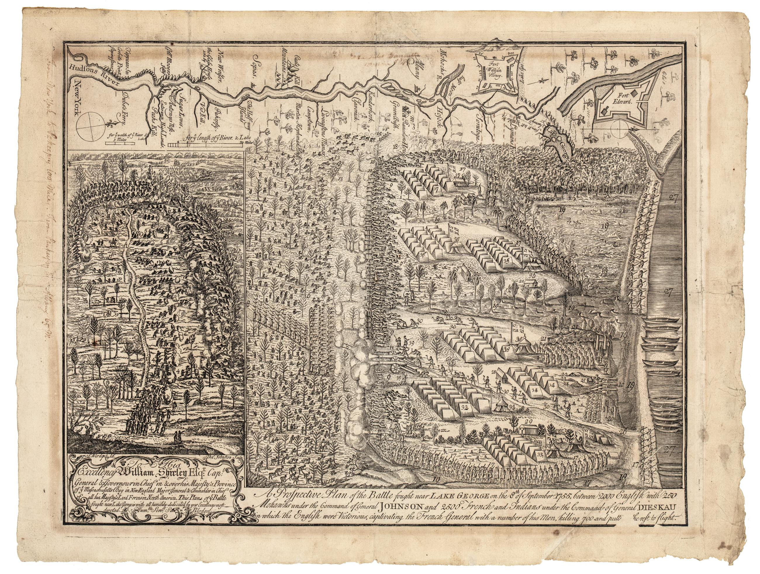
Still Image A prospective plan of the battle fought near Lake George on the 8th of September, 1755 : between 2000 English with 250 Mohawks under the command of general Johnson and 2500 French and Indians under the command of general Dieskau in which the English were This is the first historical print engraved in America. Blodget witnessed the battle and immediately afterwards drew the original plan from which Thomas Johnston made the line engraving. Relief shown pictorally. New-York Historical's copy: Handwritten note on side of map, "From New York to Pakeepsy 100 Miles. From Paukeepsy to Albany 65 m." View Item
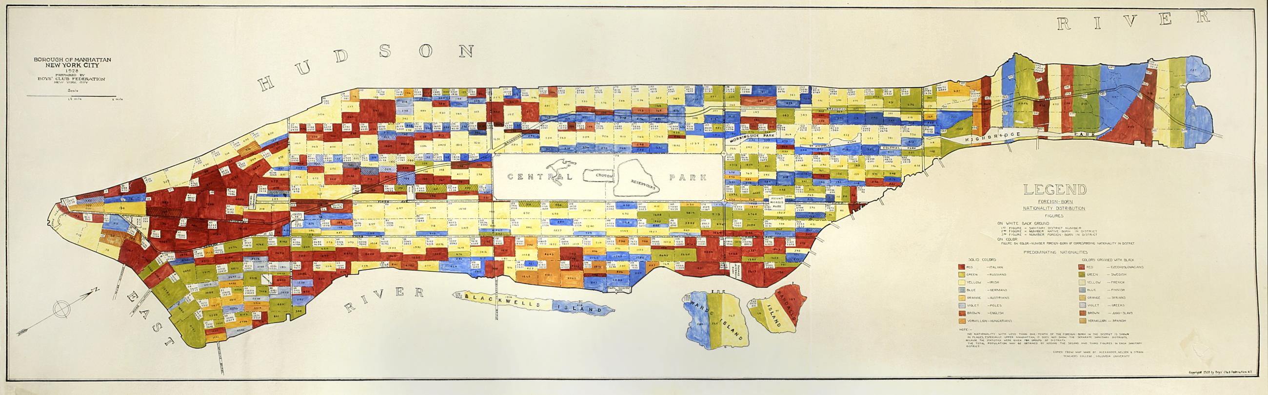
Still Image Borough of Manhattan, New York City, 1928 : Foreign-born nationality distribution figures / prepared by Boys' Club Federation, New York City Subtitle from legend: Foreign-born nationality distribution figures. Map and legend are hand colored, some areas are hand numbered. "Copied from map made by Alexander, Nelsen and Strain, Teachers College, Columbia University." View Item
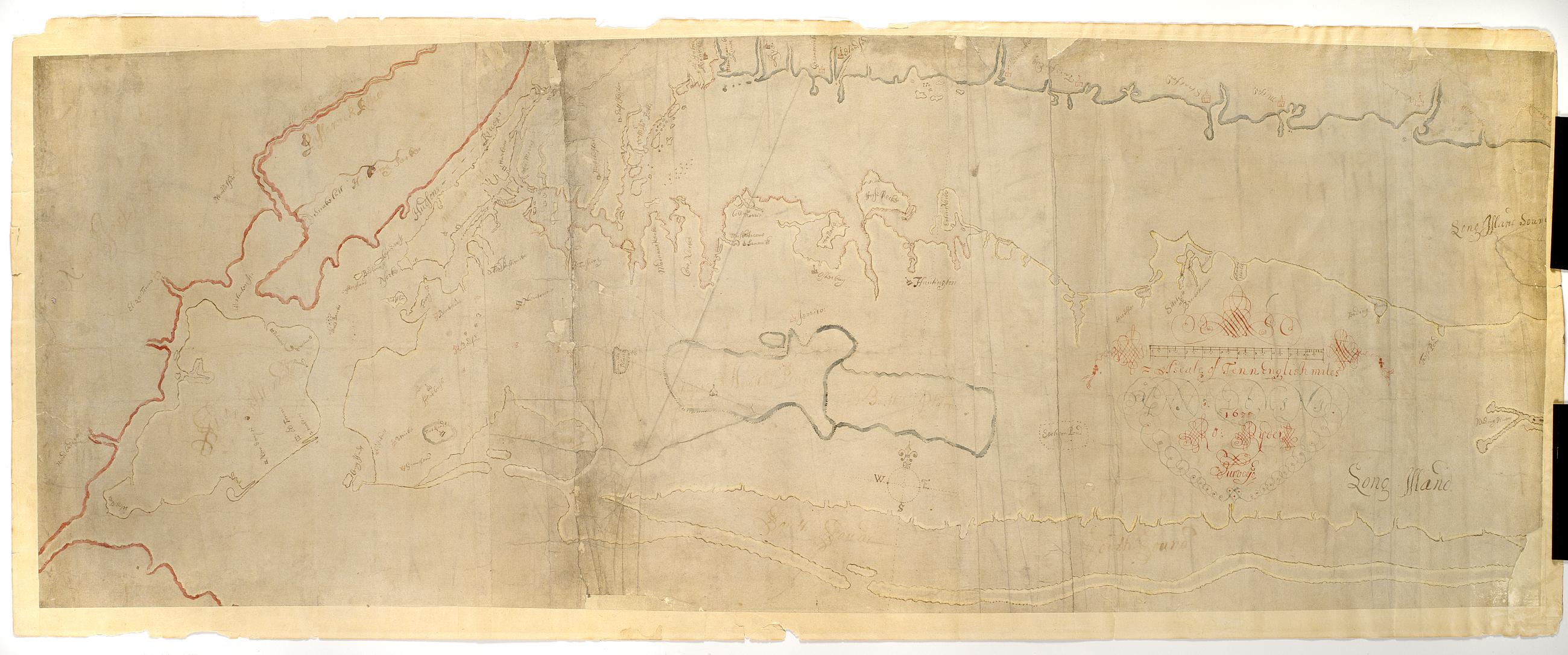
Still Image [Map of Long Island and adjacent areas of Connecticut, New York and New Jersey] / Ro. Ryder surveyed Pen-and-ink (black and color), color wash on laid paper. This is the manuscript of the earliest survey known of Long Island as far east as Riverhead. "ANNO DOMINI 1670" embedded in cartouche decoration. A shoreline map, it shows most of Long Island, all of modern New York City and the shorelines of Connecticut and New Jersey, marks the rocky coast in red, gives placenames, and outlines the various colonies in different colors. View Item
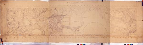
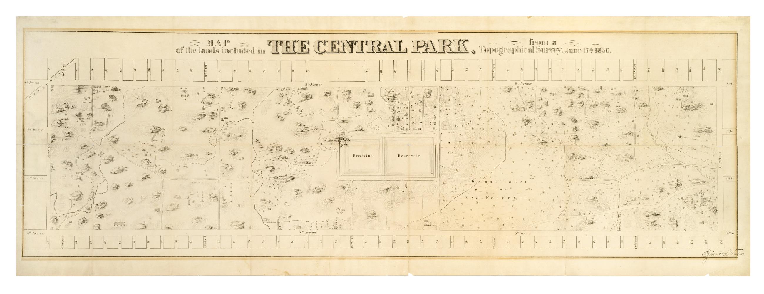
Still Image Map of the lands included in the Central Park, from a topographical survey, June 17th 1856 The Egbert L. Viele map of Central Park. Covers the area later bounded by 59th and 106th Streets, 5th Avenue and Central Park West, Manhattan, New York (N.Y.). Shows rock outcrops, buildings, reservoir, existing roads. Also shows landforms and streams. Shows relief by hachures. Oriented with north to right of sheet. "Engr. by Ferd. Mayer & Co." on companion map. From First Annual Report of the Board of Commissioners of the Central Park, January 1857. View Item
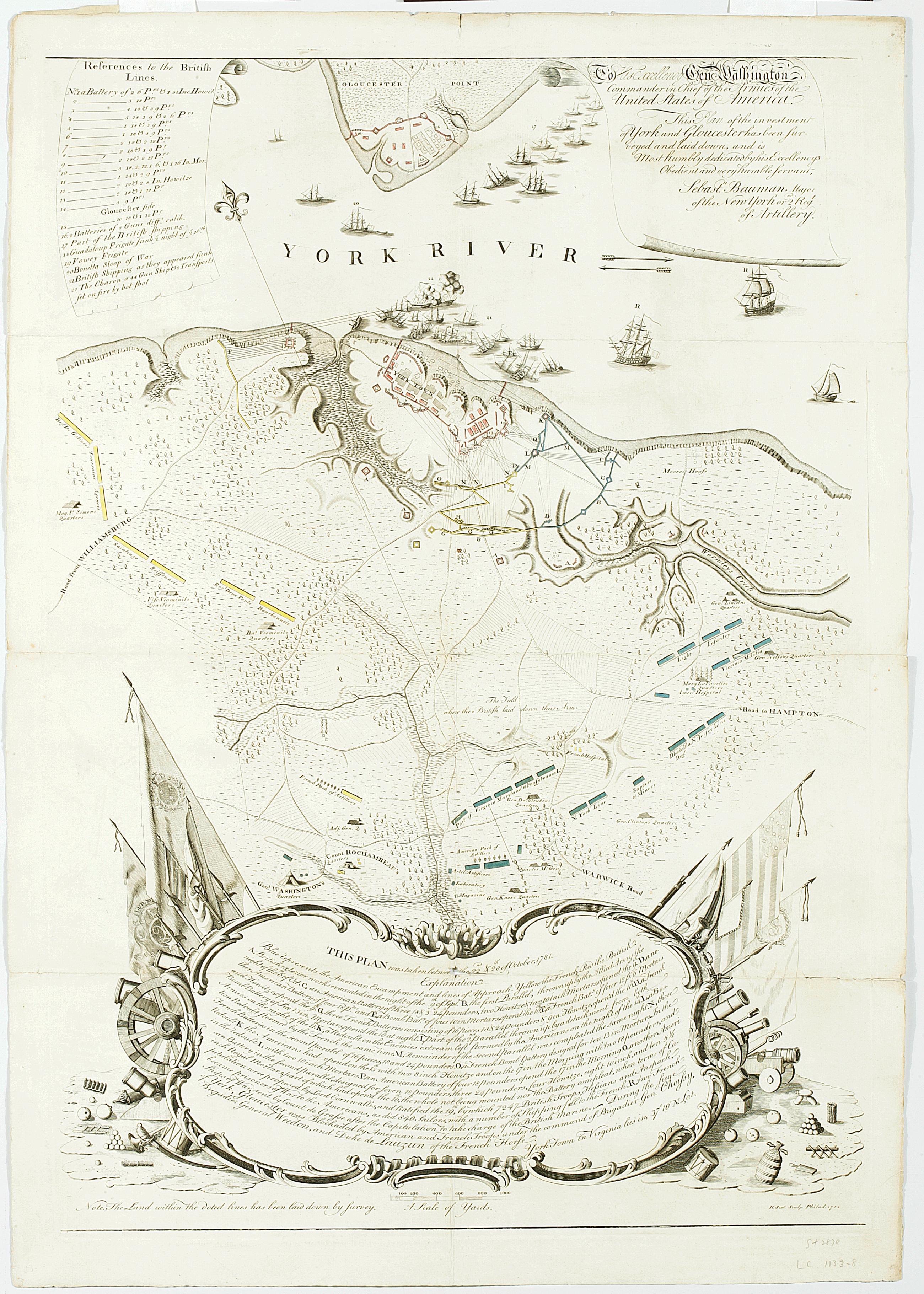
Still Image To His Excellency Genl. Washington, Commander in Chief of the armies of the United States of America. : this plan of the investment of York and Gloucester has been surveyed and laid down, and is most humbly dedicated by His Excellency's obedient servant, General Washington asked Major Sebastian Bauman, an American artillery officer and military engineer, to survey the terrain and battle positions at Yorktown, three days after the British surrendered there. It was the first large-scale battle map printed in the United States, sold by subscription only with relatively few sheets printed. New-York Historical holds two copies, one of which is believed to be Bauman's personal copy. View Item
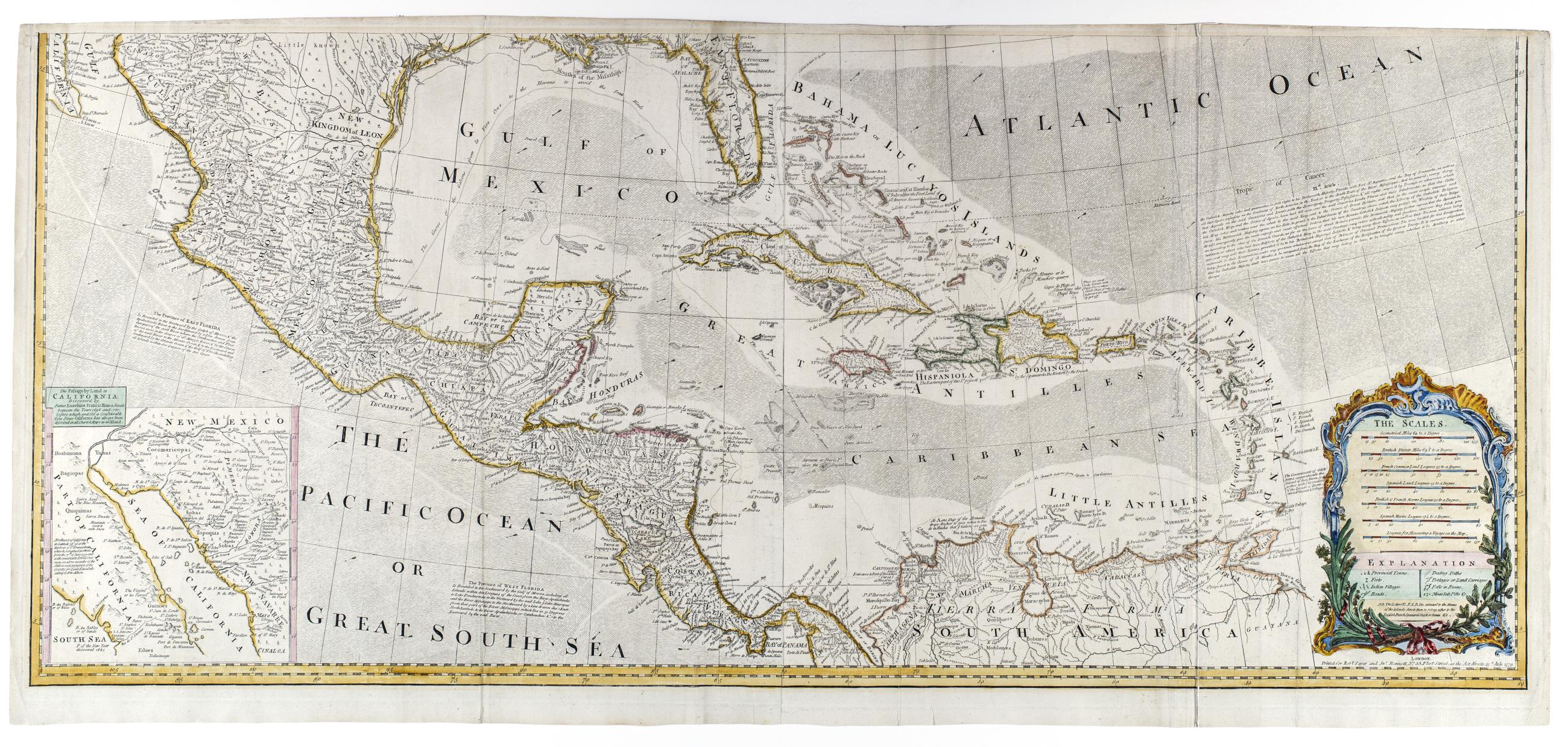
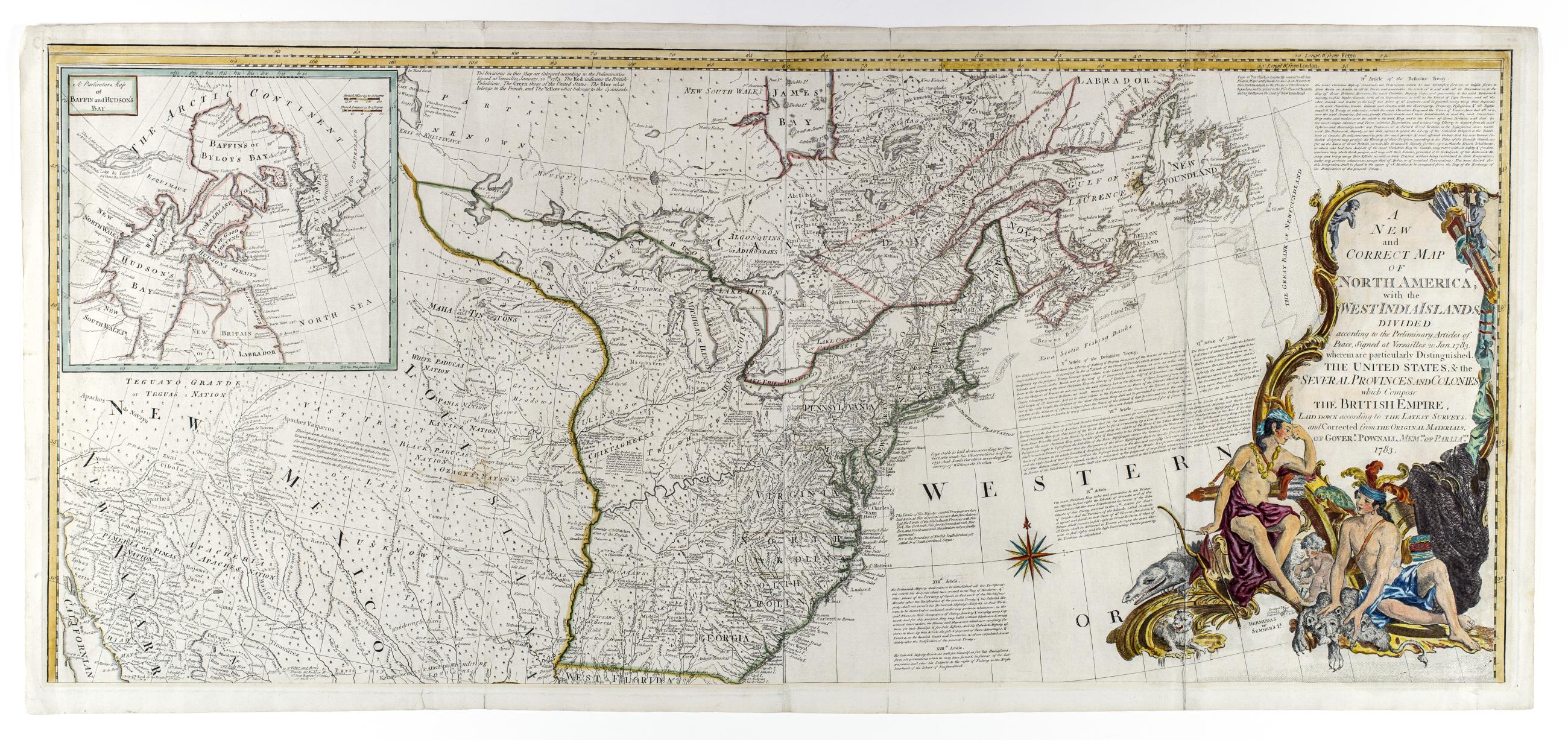
Still Image A new and correct map of North America, with the West India islands, divided according to the preliminary articles of peace, signed at Versailles, 20 Jan. 1783, wherein are particularly distinguished the United States, & the several provinces and colonies New state of 1779 issue showing 1783 boundaries and with changes to the title but retaining the 1779 date in imprint; The map includes articles 4, 5, 7, 9, 17, 18, and 20 of the Treaty of Versailles View Item
Still Image A new and correct map of North America, with the West India islands, divided according to the preliminary articles of peace, signed at Versailles, 20 Jan. 1783, wherein are particularly distinguished the United States, & the several provinces and colonies New state of 1779 issue showing 1783 boundaries and with changes to the title but retaining the 1779 date in imprint; The map includes articles 4, 5, 7, 9, 17, 18, and 20 of the Treaty of Versailles View Item
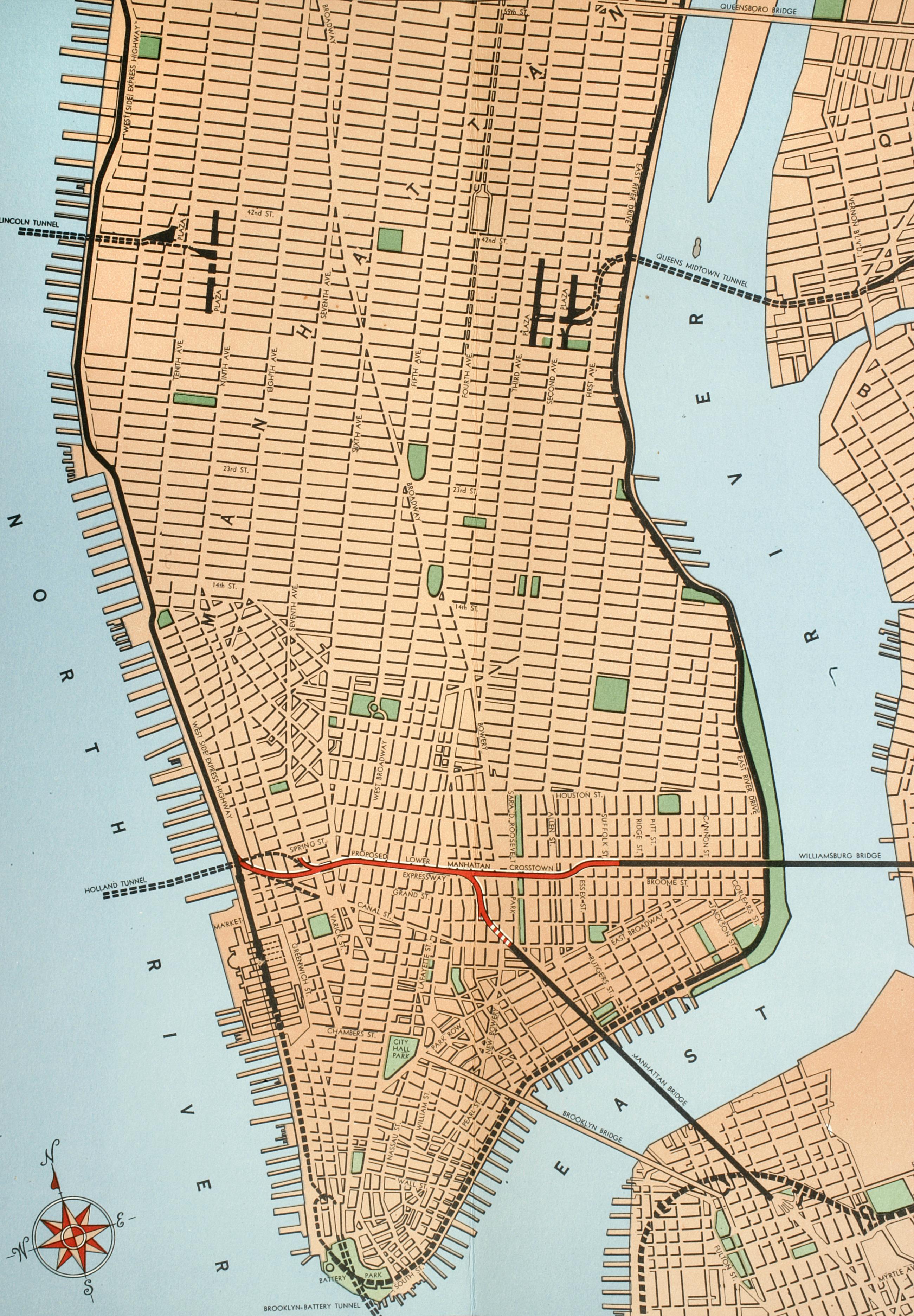
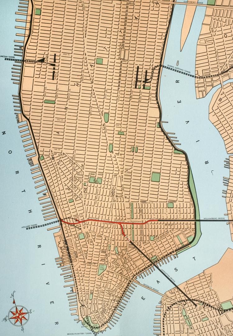
Still Image [Map of Proposed Lower Manhattan Expressway, 1946] Map from "Proposed Lower Manhattan crosstown expressway", issued by the Office of the Construction Co-ordinator, New York, 1946. View Item
Image Still Image 2 Items A new and correct map of North America, with the West India islands, divided according to the preliminary articles of peace, signed at Versailles, 20 Jan. 1783, wherein are particularly distinguished the United States, & the several provinces and colonies New state of 1779 issue showing 1783 boundaries and with changes to the title but retaining the 1779 date in imprint; The map includes articles 4, 5, 7, 9, 17, 18, and 20 of the Treaty of Versailles View Item
Image Text 2 Items Proposed Lower Manhattan crosstown expressway Selections from "Proposed Lower Manhattan crosstown expressway", issued by the Office of the Construction Co-ordinator, New York, 1946. The Lower Manhattan Expressway, an extension of I-78 from the Holland Tunnel to the Williamsburg Bridge that would have torn through the neighborhoods of SoHo, Little Italy, and the Lower East Side and displaced countless families and businesses, was originally proposed in 1941 and approved by the City Planning Commission in 1960. It was never built, thanks to opposition by neighborhood activists led by Jane Jacobs. View Item
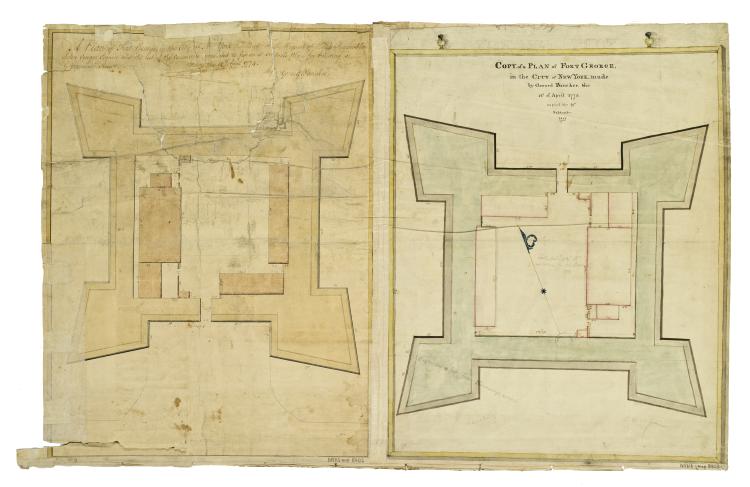
Image Collection 26 Items J.G. Swift's Report on the Defence of the City of New-York, Accompanied With Maps, Views, and Topographical Plans, 1814 "A collection of thirty-three maps, plans, and views of the fortifications constructed on Manhattan Island during the War of 1812 originally bound up with a beautifully engrossed Report on the Defence of the City of New-York ... Addressed to the Committee of the Common Council by J.G. Swift, Brigadier General, Chief Engineer of the United States, New York, 1814 ... According to a statement at the end of the report, the 'Surveys, Maps & Small views were furnished by Capt. James Renwick & Lieut. James Gadsden; aided by Lieuts. Craig, Turner, De Russy, Kemble & Oothout. Mr. View Collection
Image Collection 7 Items Richard Varick papers, 1743-1871 (bulk 1775-1830) Richard Varick, born in New Jersey, 1753, served as Captain, deputy muster-master-general, and George Washington's secretary during the Revolutionary war. He was appointed one of the first mayors of New York and served from 1789-1801. He died in 1831. His papers pertain to a variety of subjects, including Varick's command of a company in Alexander McDougall's battalion at Ticonderoga and in Canada during 1775; his service on courts-martial in 1775; problems of the bateau service in northern New York State in 1776; his position as secretary to Gen. View Collection
Image Collection 16 Items Duane family papers, 1665-1916. Series IV: Bound volumes, 1754-1843. View Collection