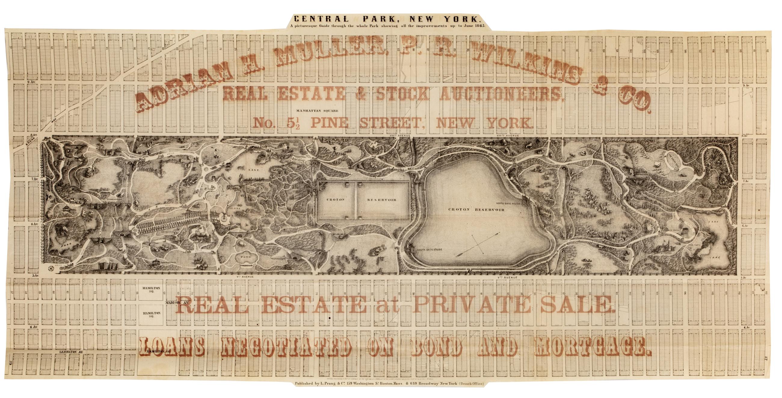
Cartographic Central Park, New York : a picturesque guide through the whole park showing all the improvements up to June 1865 Park map. Covers the area later bounded by 57th and 112th Streets, Third and Amsterdam Avenues, Manhattan, New York (N.Y.). Shows roads, trails, bridges, buildings, reservoir, gardens and plantings pictorially. Also shows landforms and streams. Oriented with north to right of sheet. "Entered according to act of Congress in the year 1865, by L. Prang & Co, in the Clerk's Office of the District Court of the District of Mass." Overprinted in red ink with: "Adrian H. Muller, P.R. Wilkins & Co., real estate and stock auctioneers, No. 5 1/2 Pine Street, New York. View Item
Still Image [Map of the area later bounded by 52nd and 74th Streets, Park Avenue, and 8th Avenue or Central Park West, Manhattan, New York, N.Y.]. Scale [ca. 1:2,450]. Cadastral map. Shows property lines and owners' names, some existing roads and projected streets. Pen-and-ink, watercolor on paper. Annotations in a later hand on this recto of this sheet give the number 34. The map on recto of this sheet belongs to the same series and is separately cataloged under the title, [Map of the area later bounded by 8th and 34th Streets, the East River and 5th Avenue, Manhattan, New York, N.Y.]. View Item
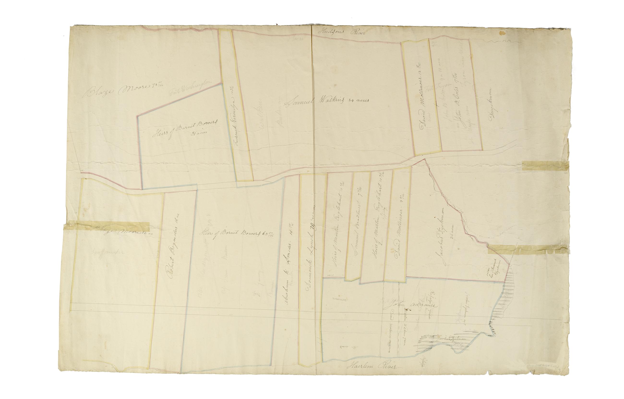
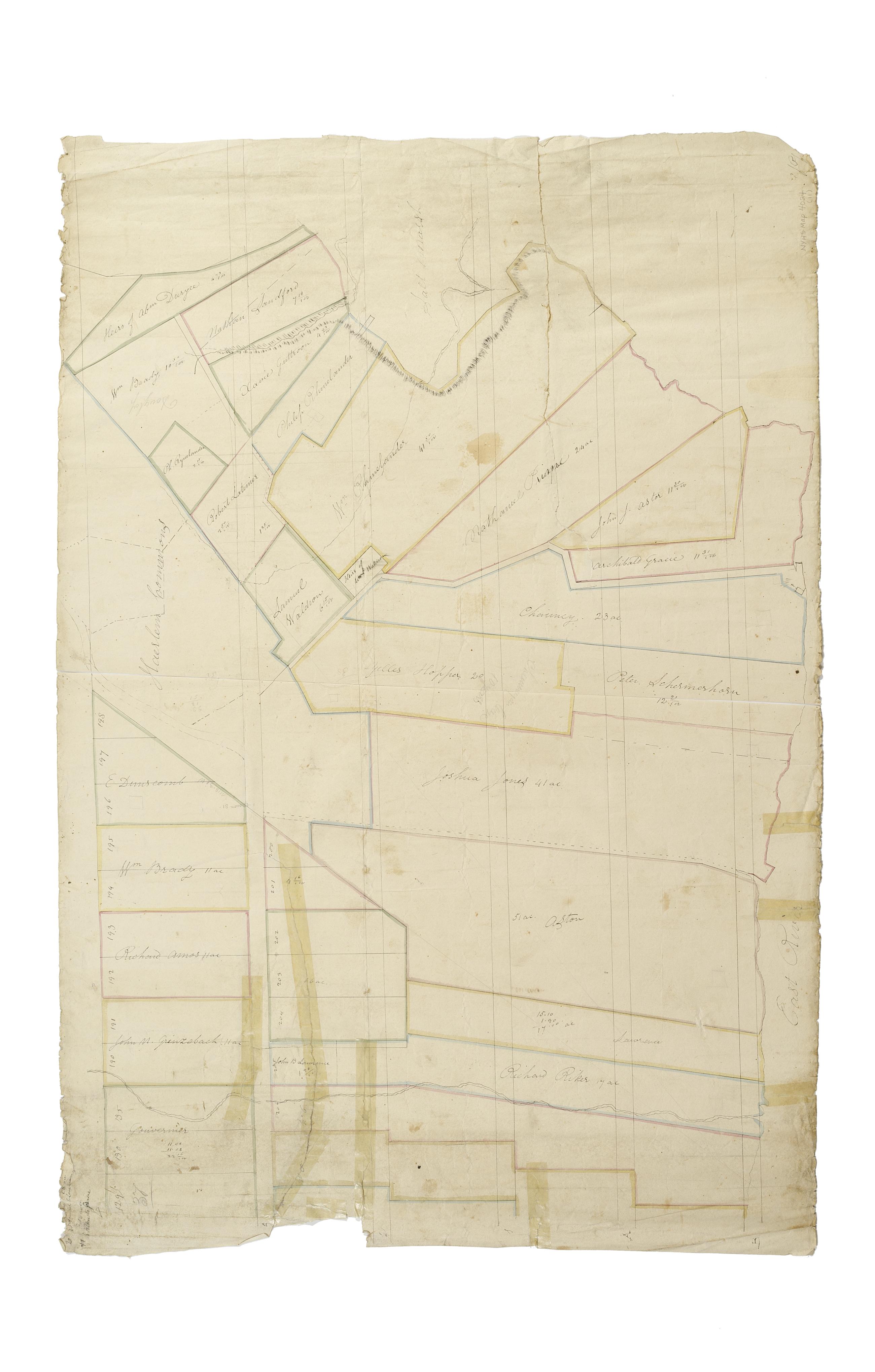
Still Image [Map of the area later bounded by 93rd and 115th Streets, the East or Harlem River and Park Avenue, Manhattan, New York, N.Y.]. Scale [ca. 1:2,450]. Cadastral map. Shows property lines and owners' names, some existing roads and projected streets. Shows relief by hachures. Pen-and-ink, watercolor on paper. Annotations in a later hand on the recto of this sheet give the number 15. The map on recto of this sheet belongs to the same series and is separately cataloged under the title, [Map of the area later bounded by 93rd and 118th Streets, 8th Avenue and the Hudson River, Manhattan, New York, N.Y.]. View Item
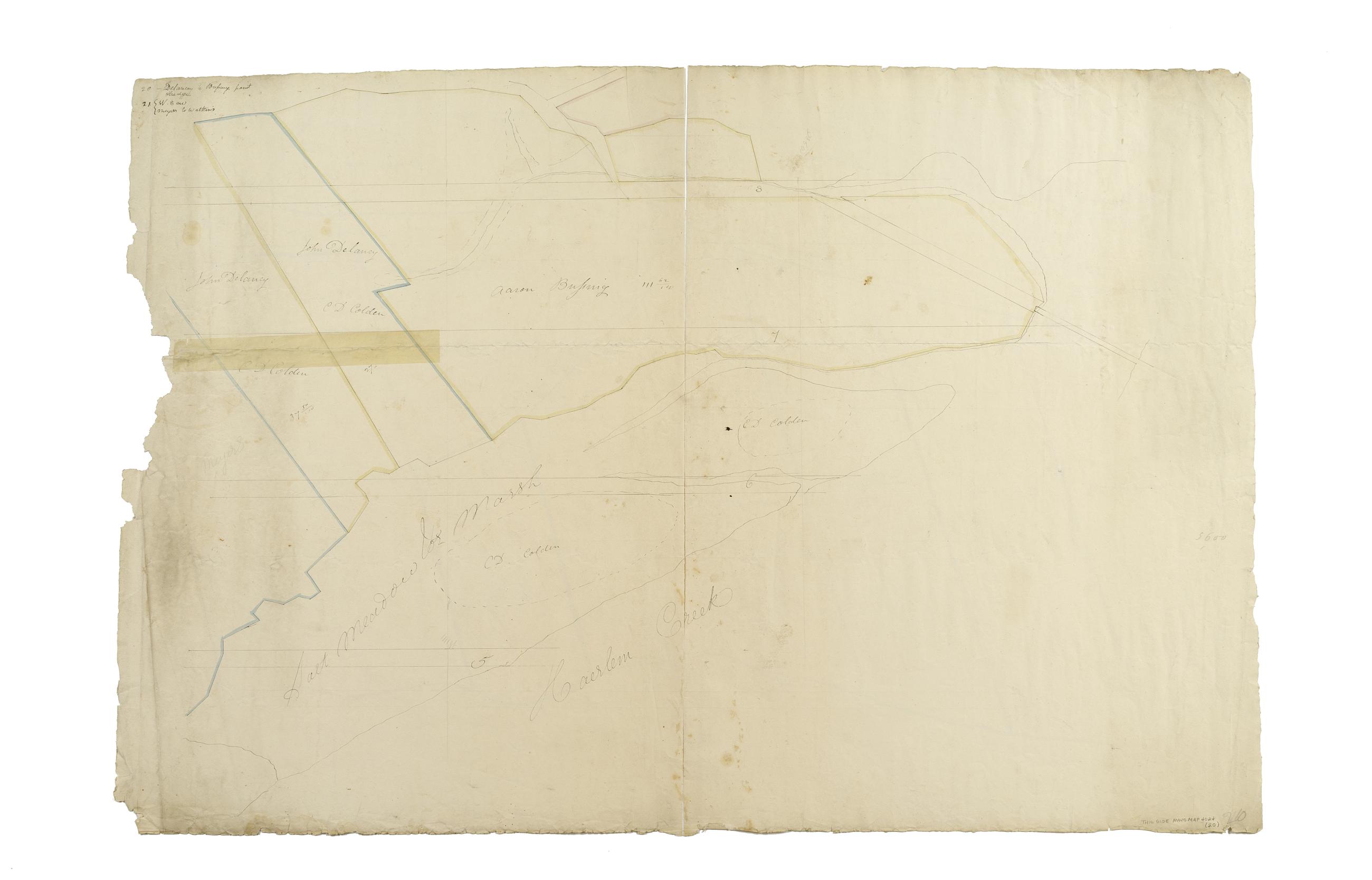
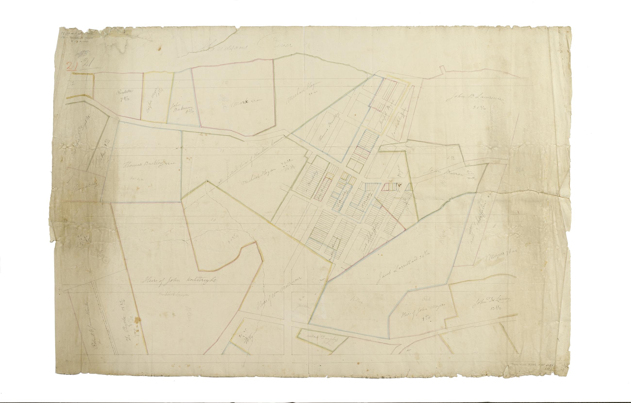
Still Image [Map of the area later bounded by 135th and 157th Streets, the Harlem River and Douglas Boulevard, Manhattan, New York, N.Y.]. Scale [ca. 1:2,450]. Cadastral map. Shows property lines and owners' names, some existing roads and projected streets. Shows relief by hachures. Pen-and-ink, watercolor on paper. Annotations in a later hand on the recto of this sheet give the number 20. The map on verso of this one belongs to the same series and is separately cataloged under the title, [Map of the area later bounded by 129th and 158th Streets, Douglass Boulevard and the Hudson River, Manhattan, New York, N.Y.]. View Item
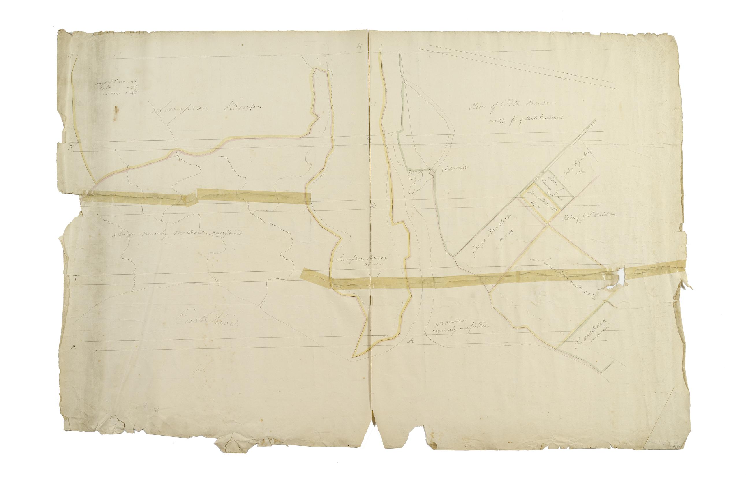
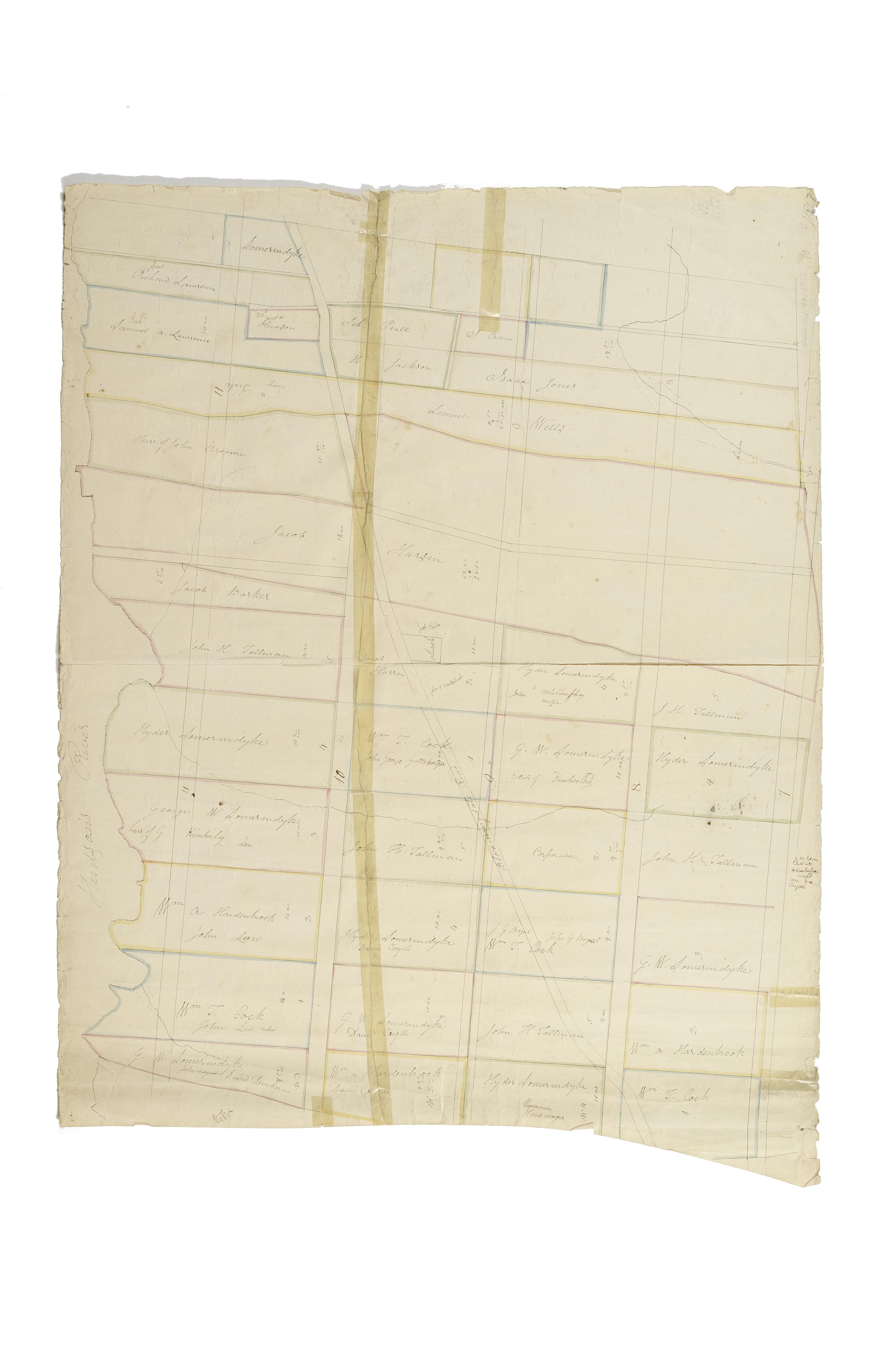
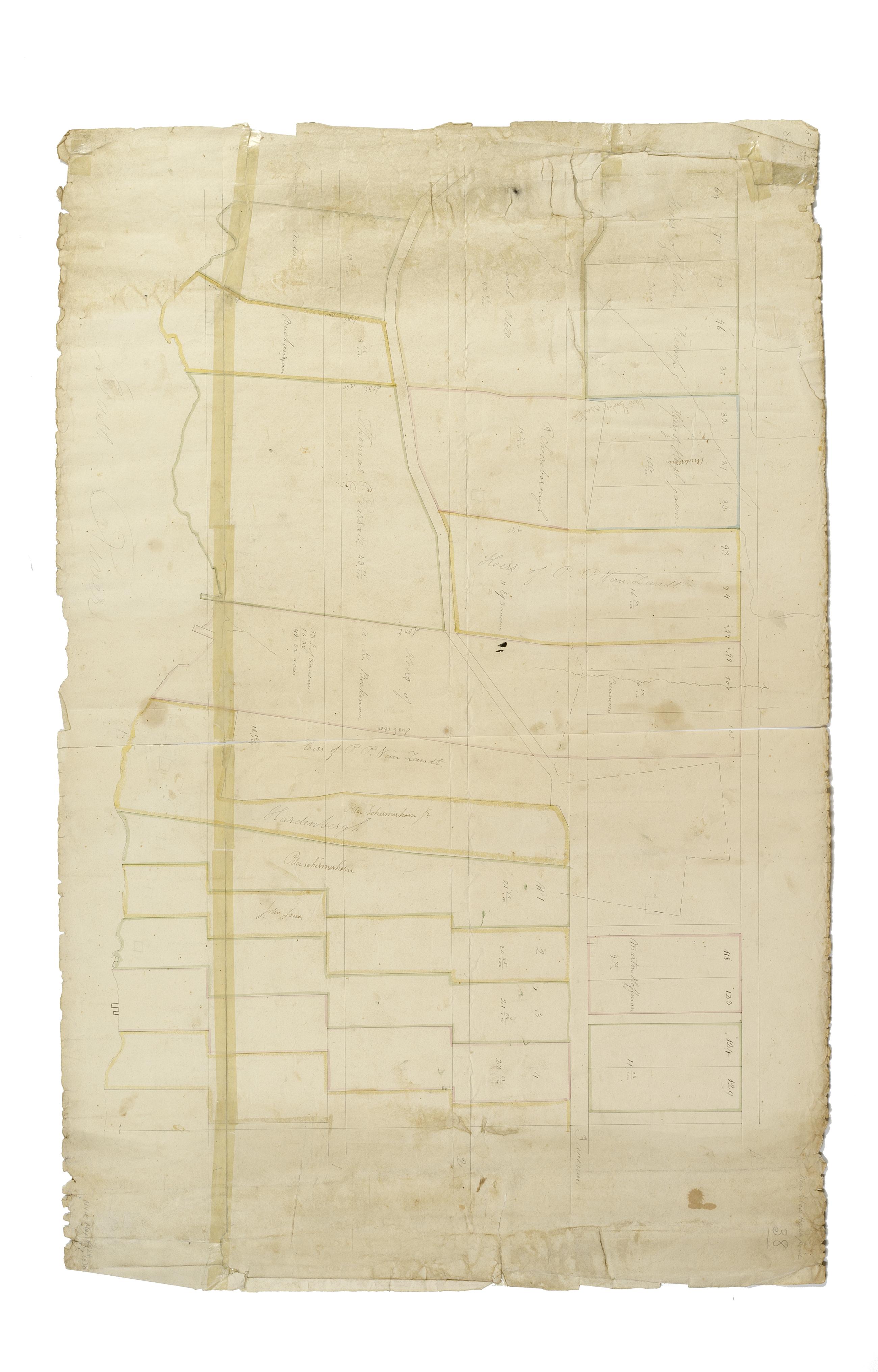
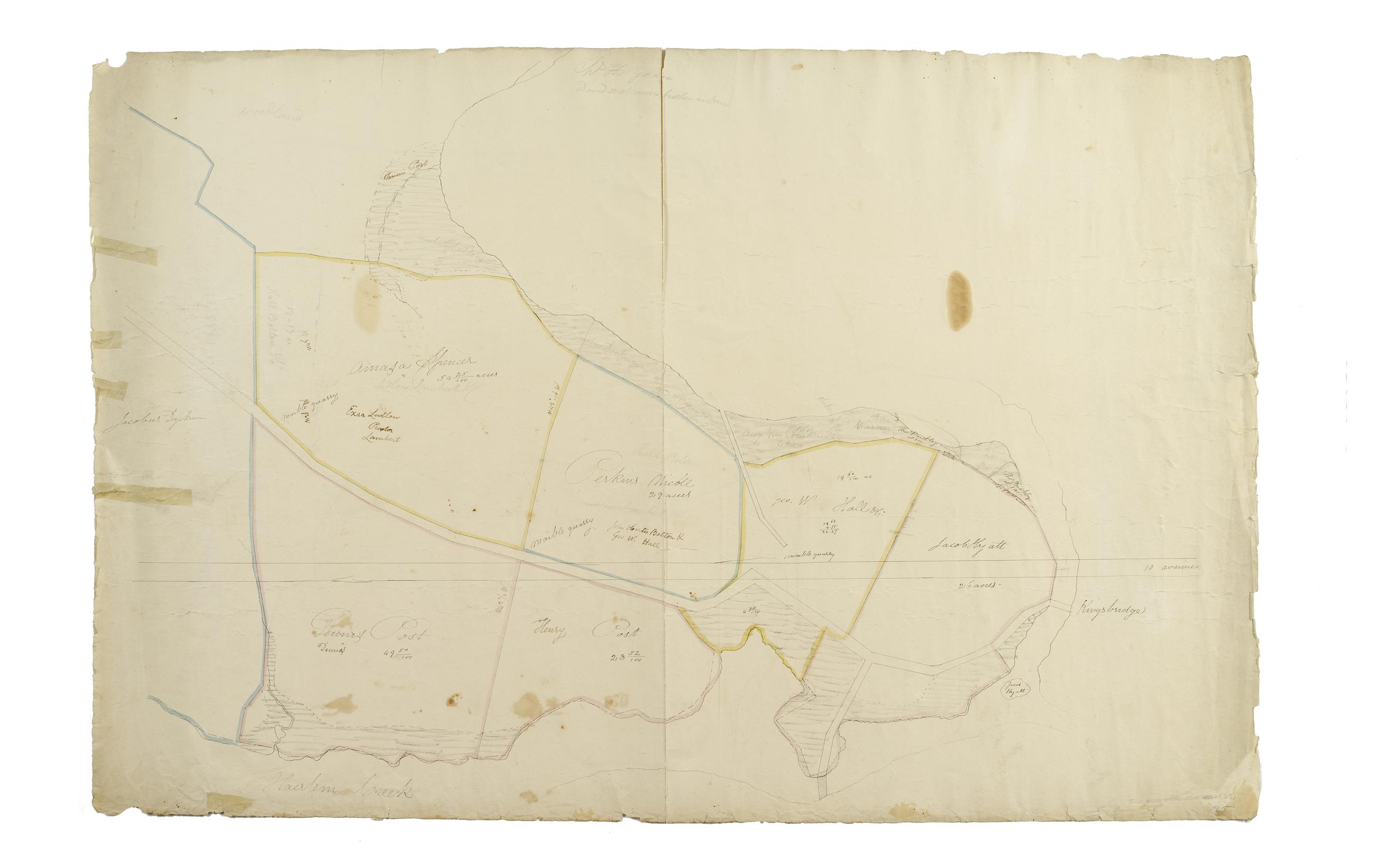
Still Image [Map of the area later bounded by 114th and 137th Streets, the Harlem River and 5th Avenue, Manhattan, New York, N.Y.]. Scale [ca. 1:2,450]. Cadastral map. Shows property lines and owners' names, some existing roads and projected streets. Shows relief by hachures. Pen-and-ink, watercolor on paper. Imperfect: lacking 15 cm. square at bottom center margin. Annotations in a later hand on the recto of this sheet give the number 16. The map on verso of this one belongs to the same series and is separately cataloged under the title, [Map of the area later bounded by 113th and 136th Streets, Park or Morningside and St. Nicholas Avenues, Manhattan, New York, N.Y.]. View Item
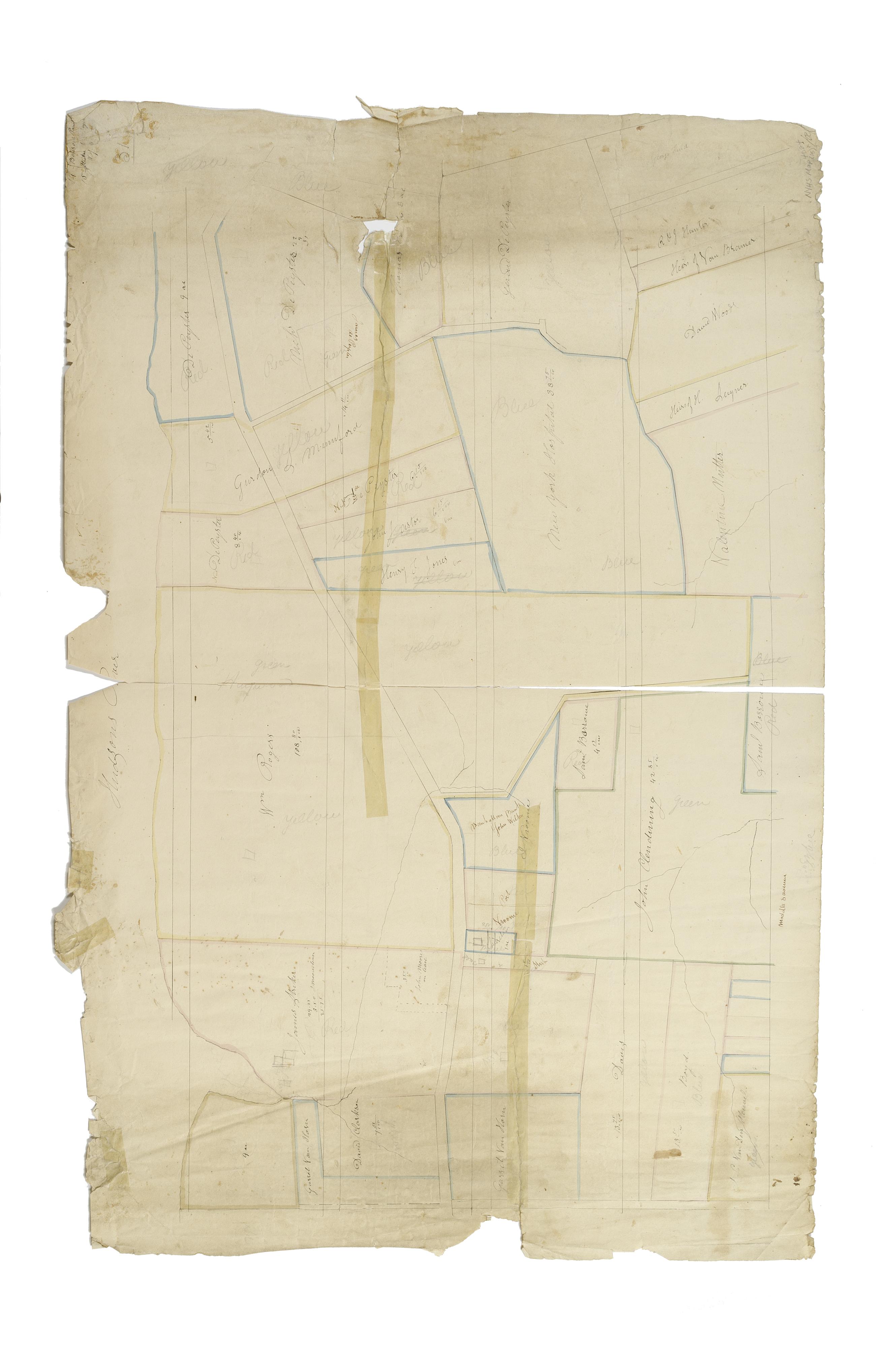
Still Image [Map of the area later bounded by 129th and 158th Streets, Douglass Boulevard and the Hudson River, Manhattan, New York, N.Y.]. Scale [ca. 1:2,450]. Cadastral map. Shows property lines and owners' names, some existing roads and projected streets. Shows relief by hachures. Pen-and-ink, watercolor on paper. Annotations in a later hand on the recto of this sheet also give the number 21. The map on recto of this sheet belongs to the same series and is separately cataloged under the title, [Map of the area later bounded by 135th and 157th Streets, the Harlem River and Convent Avenue, Manhattan, New York, N.Y.]. View Item
Still Image [Cadastral map of Manhattan]. Scale [ca. 1:2,450]. Digital composite of a cadastral map of Manhattan in 26 sections on 13 sheets which appears to be a draft for another map, owned by New York City and printed in Sackersdorff, Otto. Maps of farms, commonly called the Blue Book 1815 (New York: 1868). Shows property lines and owners' names, some existing roads and projected streets. Shows relief by hachures. Pen-and-ink, watercolor on paper. Sackersdorff gives the date of the manuscript map as circa 1815. Title and edition statement devised by cataloger. Attributed to Randel by cataloger; for provenance, see Stokes, I.N.P. View Item
Still Image [Map of the area later bounded by 8th and 34th Streets, the East River and 5th Avenue, Manhattan, New York, N.Y.]. Scale [ca. 1:2,450]. Cadastral map. Shows property lines and owners' names, some existing roads and projected streets. Pen-and-ink, watercolor on paper. The map on verso of this one belongs to the same series and is separately cataloged under the title, [Map of the area later bounded by 52nd and 74th Streets, Park Avenue, and 8th Avenue or Central Park West, Manhattan, New York, N.Y.]. View Item
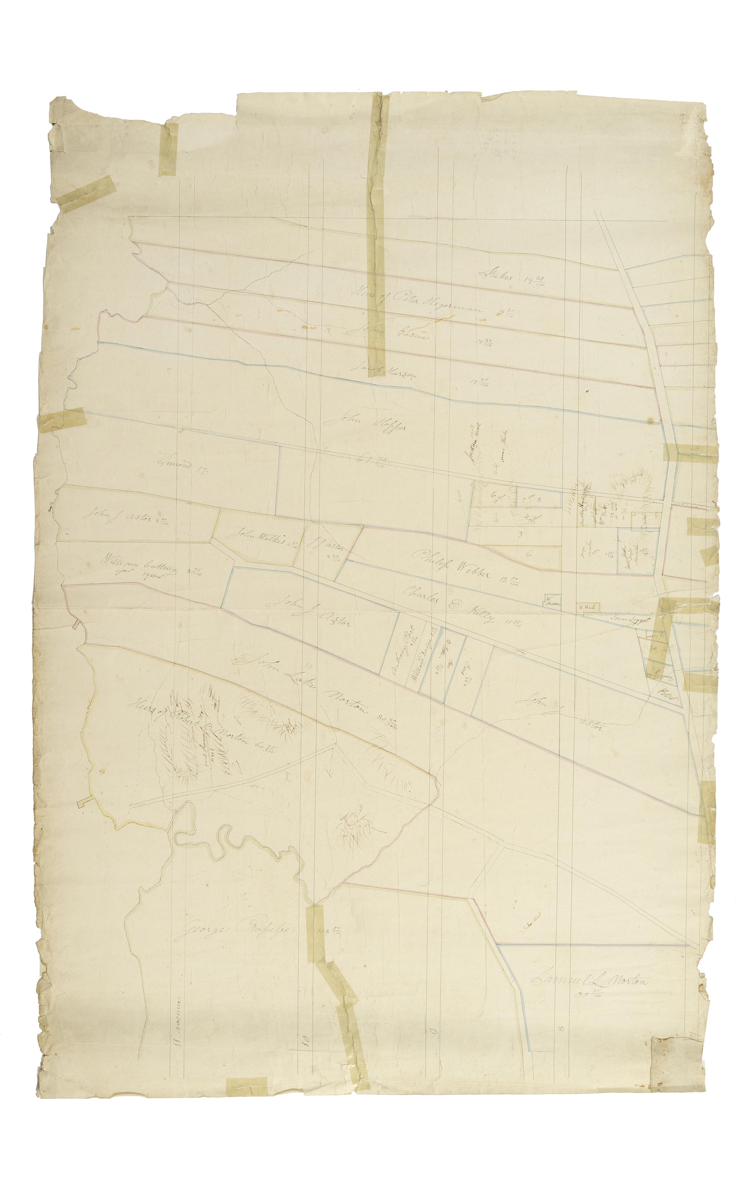
Still Image [Map of the area later bounded by 93rd and 116th Streets, Park and Columbus Avenues, Manhattan, New York, N.Y.]. Scale [ca. 1:2,450]. Cadastral map. Shows property lines and owners' names, some existing roads and projected streets. Shows relief by hachures. Pen-and-ink, watercolor on paper. Annotations in a later hand on the recto of this sheet give the number 14. The map on recto of this sheet belongs to the same series and is separately cataloged under the title, [Map of the area later bounded by 73rd and 95th Streets, 7th Avenue or Central Park, and the Hudson River, Manhattan, New York, N.Y.]. View Item
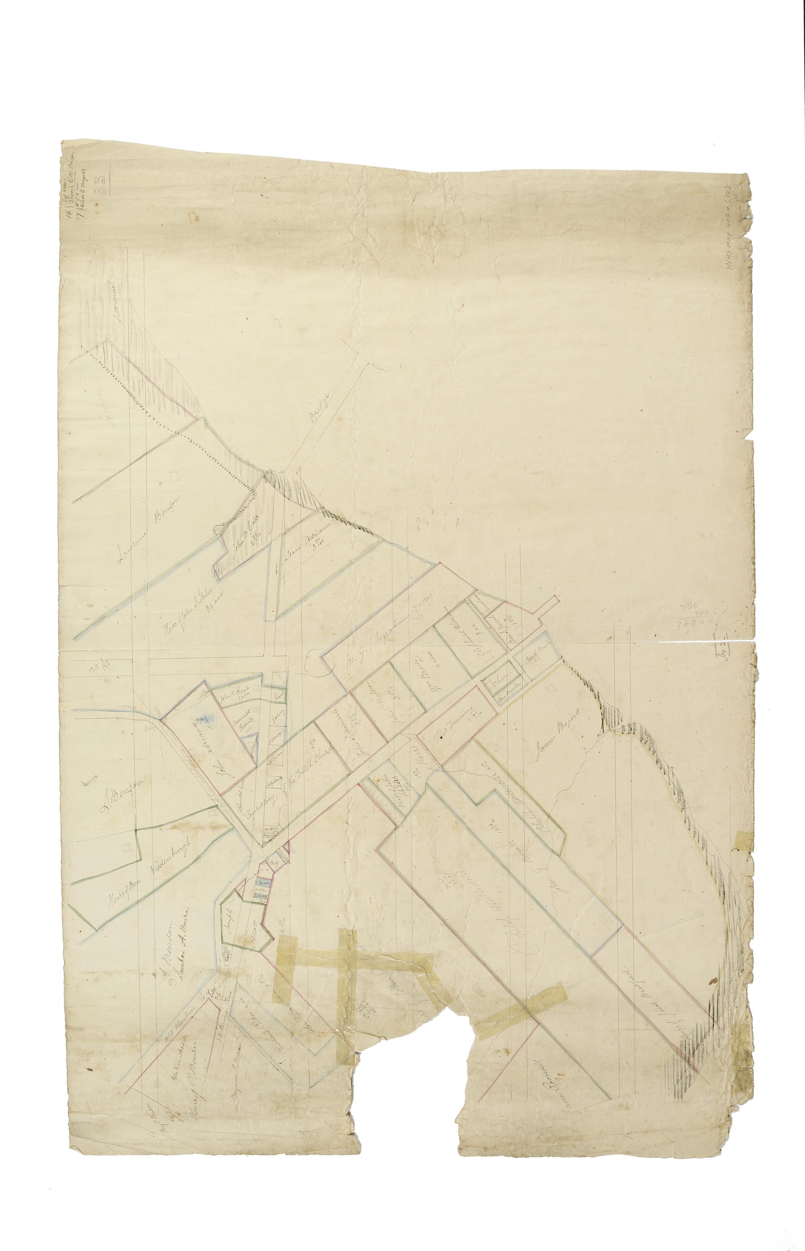
Still Image [Map of the area later bounded by 113th and 136th Streets, Park Avenue and Douglas Boulevard, Manhattan, New York, N.Y.]. Scale [ca. 1:2,450]. Cadastral map. Shows property lines and owners' names, some existing roads and projected streets. Shows relief by hachures. Pen-and-ink, watercolor on paper. Imperfect: lacking 15 cm. square at bottom center. Annotations in a later hand on the recto of this sheet give the number 17. The map on recto of this sheet belongs to the same series and is separately cataloged under the title, [Map of the area later bounded by 114th and 137th Streets, the Harlem River and 5th Avenue, Manhattan, New York, N.Y.]. View Item
Still Image [Map of the area later bounded by 177th and 201st Streets, the Harlem and Hudson Rivers, Manhattan, New York, N.Y.]. Scale [ca. 1:2,450]. Cadastral map. Shows property lines and owners' names, some existing roads and projected streets. Shows relief by hachures. Pen-and-ink, watercolor on paper. Annotations in a later hand on the recto of this sheet give the number 23. The map on recto of this sheet belongs to the same series and is separately cataloged under the title, [Map of the area later bounded by 156th and 178th Streets, the Harlem and Hudson Rivers, Manhattan, New York, N.Y.]. View Item
Still Image [Map of the area later bounded by 56th and 78th Streets, 7th Avenue or Central Park, and the Hudson River, Manhattan, New York, N.Y.]. Scale [ca. 1:2,450]. Cadastral map. Shows property lines and owners' names, some existing roads and projected streets. Shows relief by hachures. Pen-and-ink, watercolor on paper. Imperfect: lacking 15 cm. at bottom margin. Annotations in a later hand on the recto of this sheet give the number 10. The map on recto of this sheet belongs to the same series and is separately cataloged under the title, [Map of the area later bounded by 8th and 20th Streets, 7th Avenue and the Hudson River, Manhattan, New York, N.Y.]. View Item
Still Image [Map of the area later bounded by 73rd and 94th Streets, Park Avenue and Central Park West, Manhattan, New York, N.Y.]. Scale [ca. 1:2,450]. Cadastral map. Shows property lines and owners' names, some existing roads and projected streets. Shows relief by hachures. Pen-and-ink, watercolor on paper. Annotations in a later hand on the recto of this sheet give the number 12. The map on verso of this one belongs to the same series and is separately cataloged under the title, [Map of the area later bounded by 10th and 21st Streets, 3rd and 6th Avenues, Manhattan, New York, N.Y.]. View Item
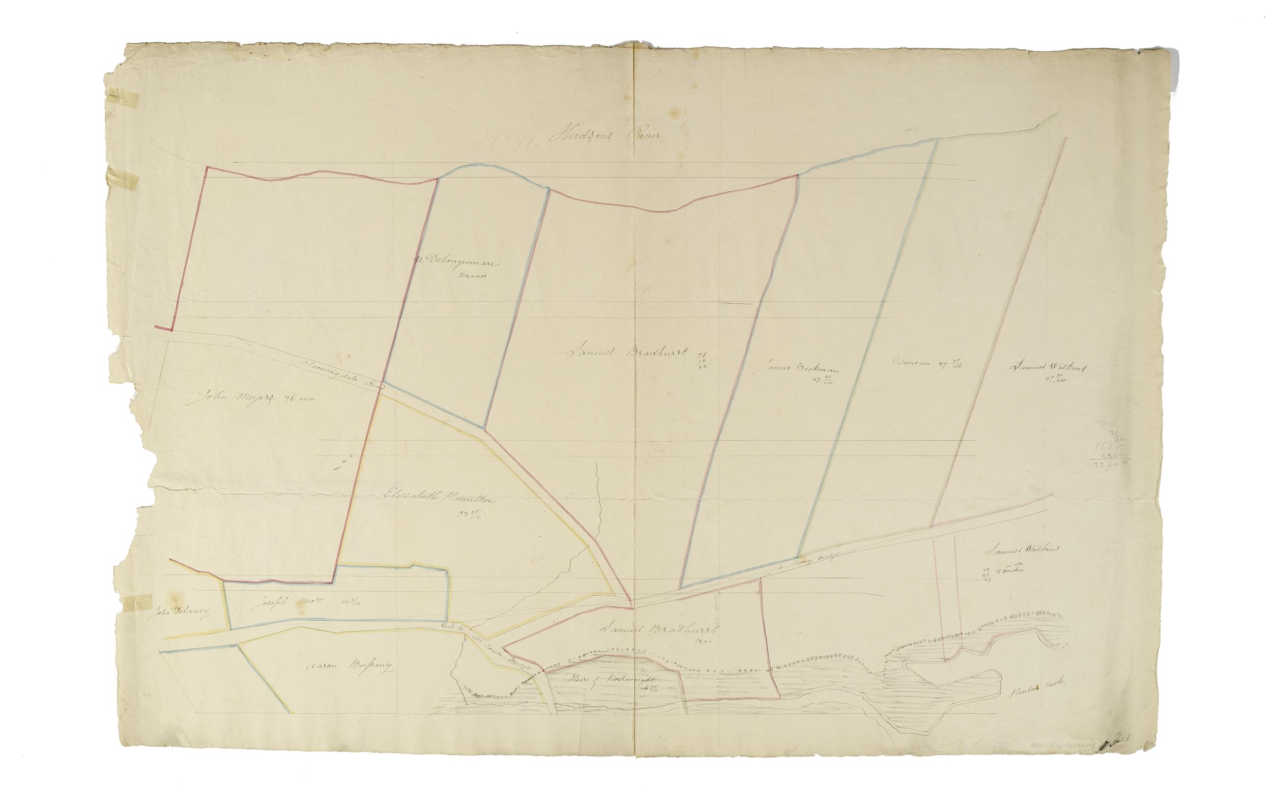
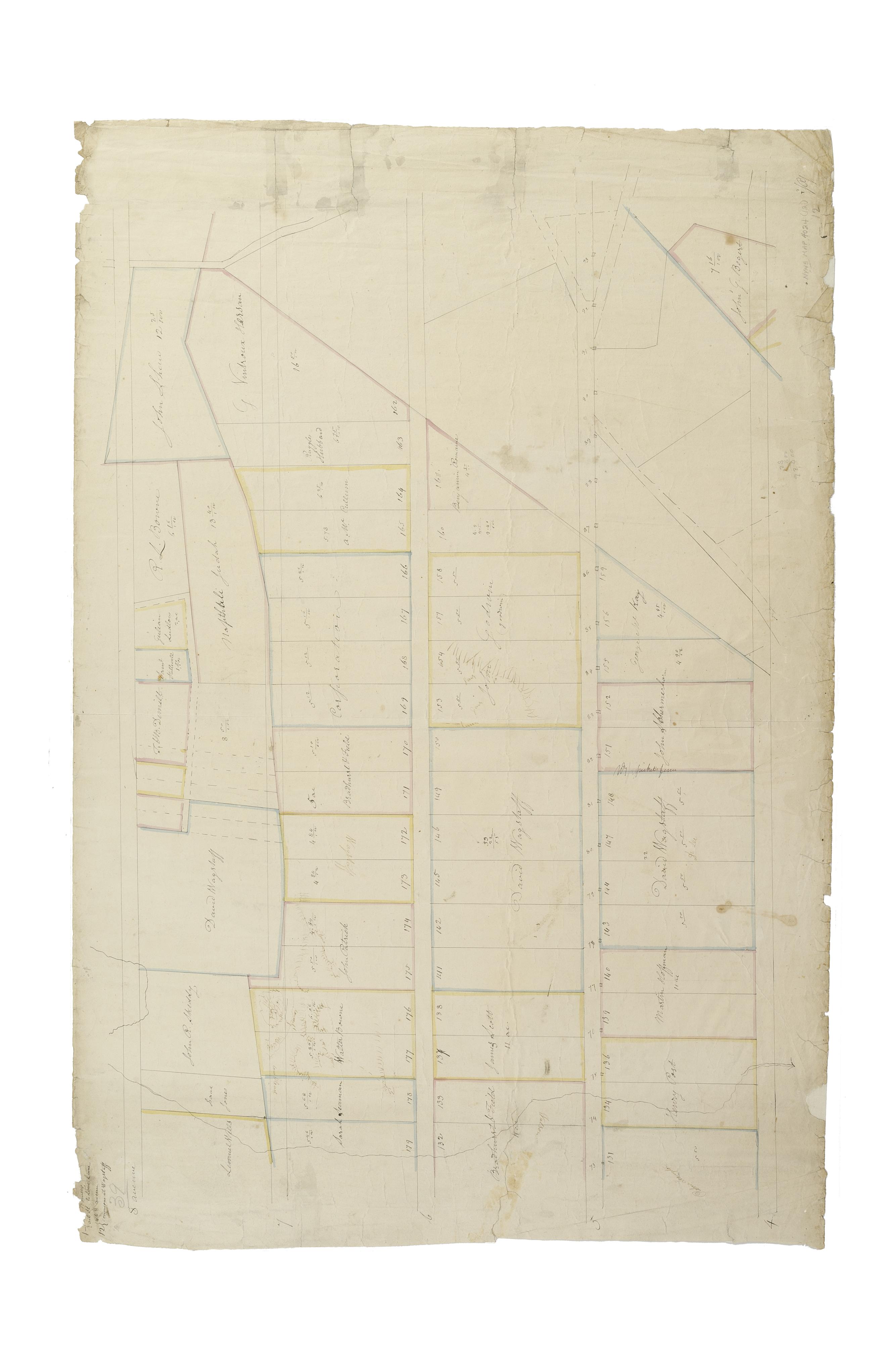
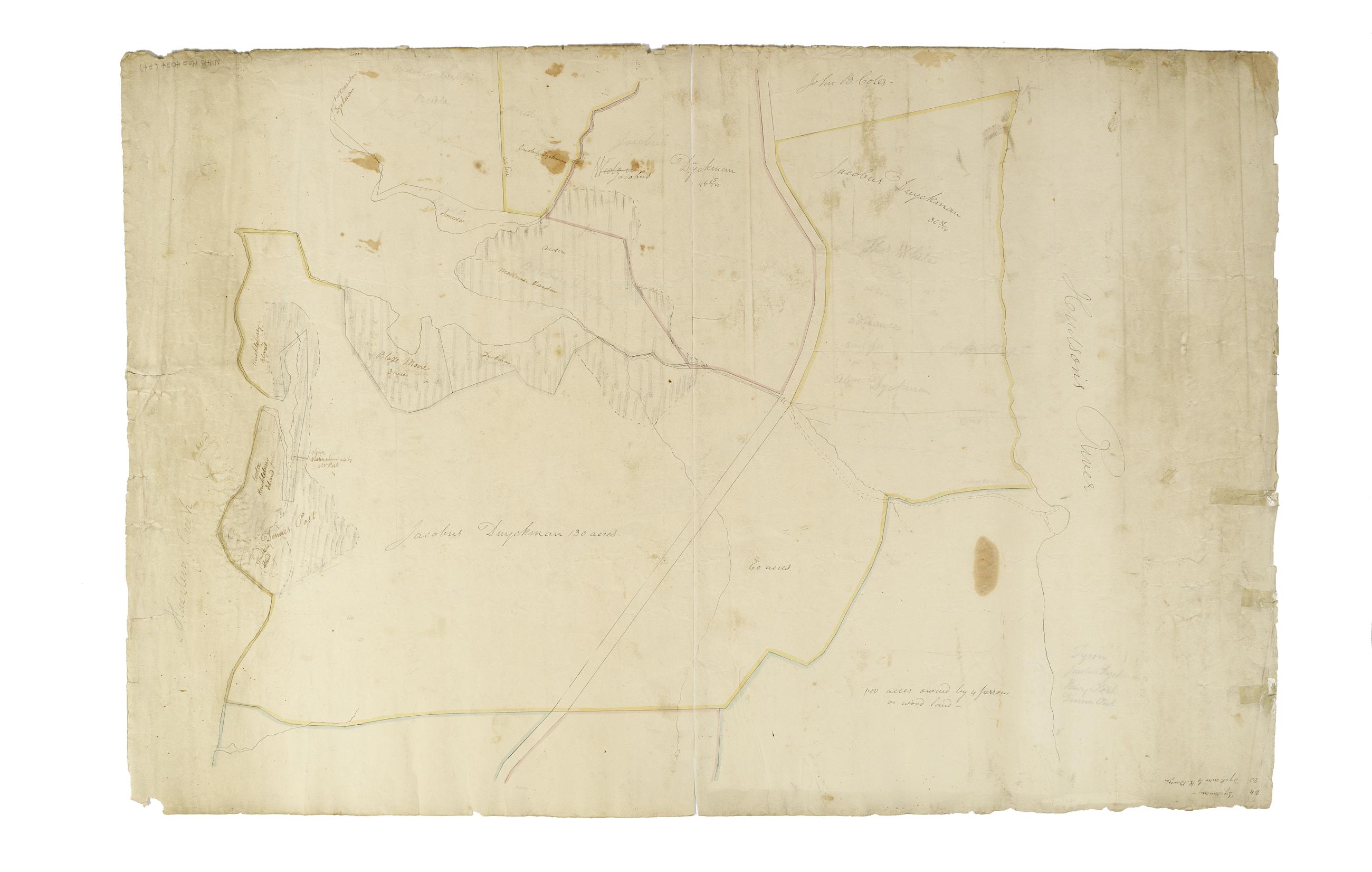
Still Image [Map of the area later bounded by 114th and 137th Streets, Douglass Boulevard and the Hudson River, Manhattan, New York, N.Y.]. Scale [ca. 1:2,450]. Cadastral map. Shows property lines and owners' names, some existing roads and projected streets. Shows relief by hachures. Pen-and-ink, watercolor on paper. Annotations in a later hand on the recto of this sheet also give the number 18. The map on verso of this one does not belong to the series and is separately cataloged--see Loss, Charles, surveyor. [Map of the area later bounded by 124th and 132nd Streets, 9th Avenue and the Hudson River, Manhattan, New York, N.Y.]. View Item
Still Image [Map of the area later bounded by 196th and 212th Streets, the Harlem and Hudson Rivers, Manhattan, New York, N.Y.]. Scale [ca. 1:2,450]. Cadastral map. Shows property lines and owners' names, some existing roads and projected streets. Shows relief by hachures. Pen-and-ink, watercolor on paper. Annotations in a later hand on the recto of this sheet give the number 24. The map on verso of this one belongs to the same series and is separately cataloged under the title, [Map of the area later bounded by 208th and 228th Streets, Manhattan, New York, N.Y.]. View Item
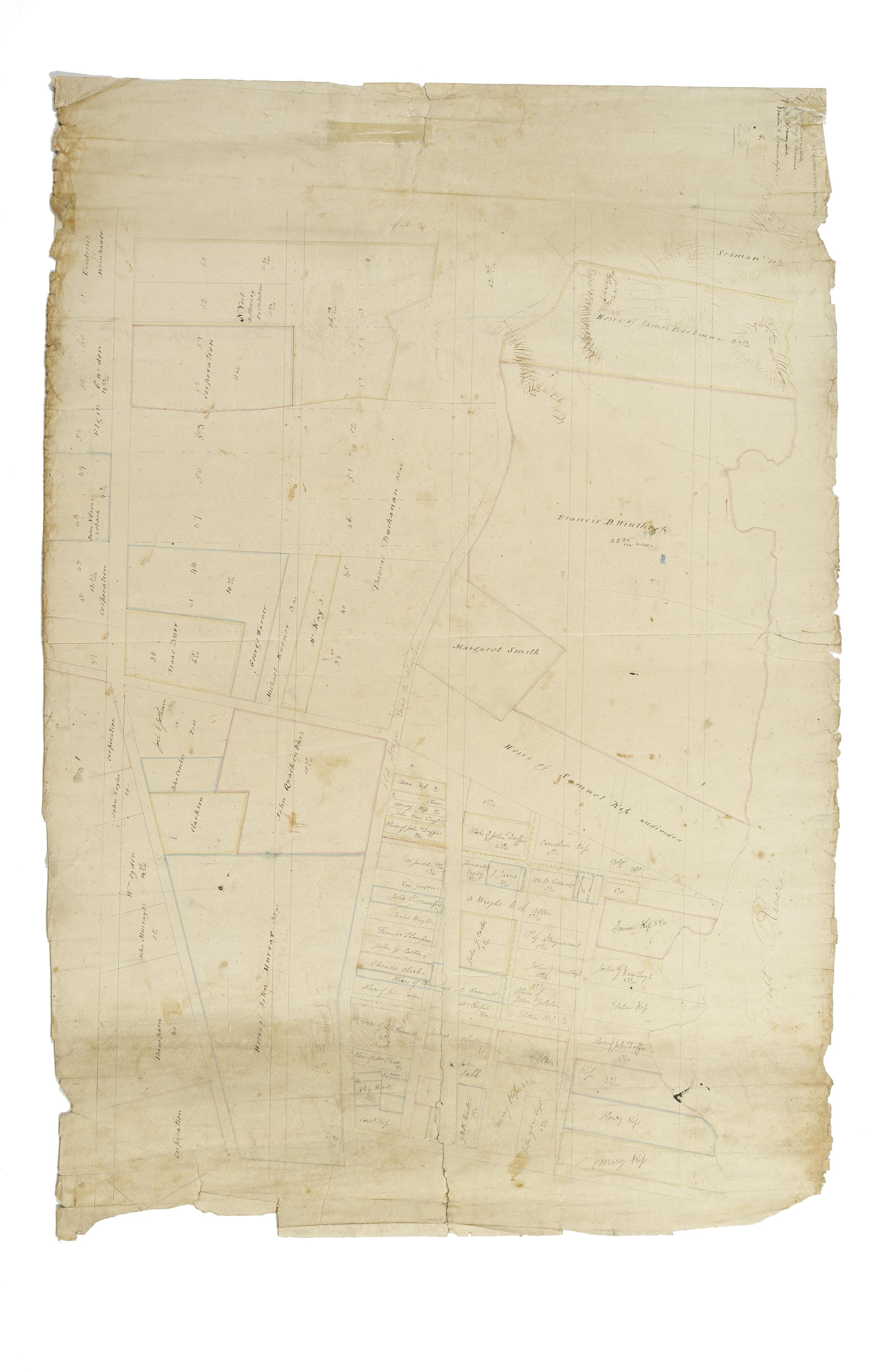
Still Image [Map of the area later bounded by 30th and 53rd Streets, the East River and 5th Avenue, Manhattan, New York, N.Y.]. Scale [ca. 1:2,450]. Cadastral map. Shows property lines and owners' names, some existing roads and projected streets. Shows relief by hachures. Pen-and-ink, watercolor on paper. Annotations in a later hand on the recto of this sheet give the number 6. The map on verso of this one belongs to the same series and is separately cataloged under the title, [Map of the area later bounded by 35th and 57th Streets, 7th and 11th Avenues, Manhattan, New York, N.Y.]. View Item
Still Image [Map of the area later bounded by 93rd and 118th Streets, Central Park West or Douglass Boulevard, and the Hudson River, Manhattan, New York, N.Y.]. Scale [ca. 1:2,450]. Cadastral map. Shows property lines and owners' names, some existing roads and projected streets. Pen-and-ink, watercolor on paper. Annotations in a later hand on the recto of this sheet give the number 15. The map on verso of this one belongs to the same series and is separately cataloged under the title, [Map of the area later bounded by 93rd and 115th Streets, the East or Harlem River and Park Avenue, Manhattan, New York, N.Y.]. View Item
Still Image [Map of the area later bounded by 15th and 33rd Streets, 6th and 10th Avenues, Manhattan, New York, N.Y.]. Scale [ca. 1:2,450]. Cadastral map. Shows property lines and owners' names, some existing roads and projected streets. Shows relief by hachures. Pen-and-ink, watercolor on paper. Annotations in a later hand on the recto of this sheet also give the number 5. The map on recto of this sheet belongs to the same series and is separately cataloged under the title, [Map of the area later bounded by 52nd and 73rd Streets, the East River and Park Avenue, Manhattan, New York, N.Y.]. View Item
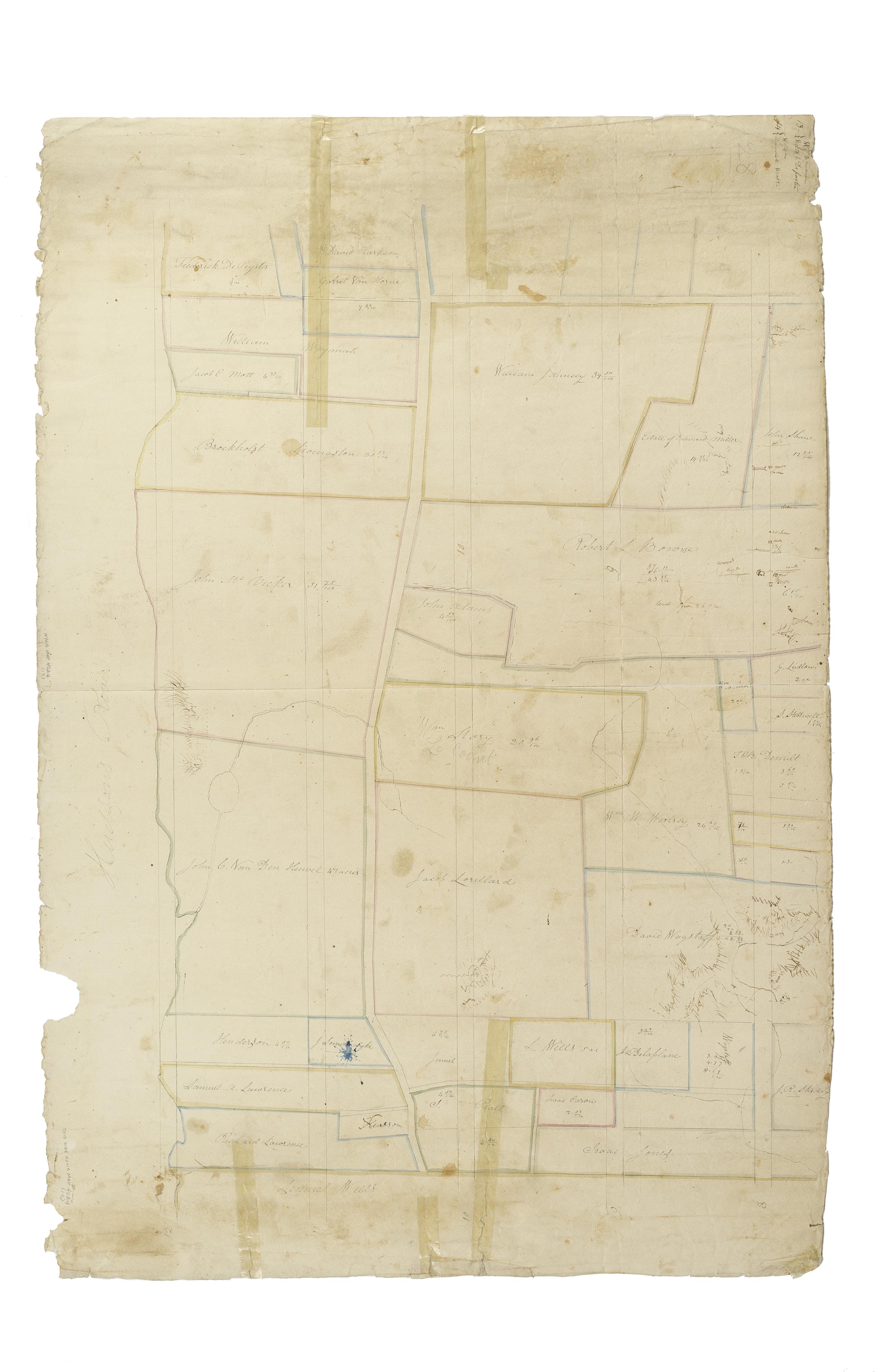
Still Image [Map of the area later bounded by 72nd and 95th Streets, the East River and Park Avenue, Manhattan, New York, N.Y.]. Scale [ca. 1:2,450]. Cadastral map. Shows property lines and owners' names, some existing roads and projected streets. Shows relief by hachures. Pen-and-ink, watercolor on paper. Annotations in a later hand on the recto of this sheet give the number 11. The map on verso of this one belongs to the same series and is separately cataloged under the title, [Map of the area later bounded by 10th and 22nd Streets, 5th and 8th Avenues, Manhattan, New York, N.Y.]. View Item
Still Image [Map of the area later bounded by 52nd and 73rd Streets, the East River and Park Avenue, Manhattan, New York, N.Y.]. Scale [ca. 1:2,450]. Cadastral map. Shows property lines and owners' names, some existing roads and projected streets. Shows relief by hachures. Pen-and-ink, watercolor on paper. Annotations in a later hand on the recto of this sheet give the number 5. The map on verso of this one belongs to the same series and is separately cataloged under the title, [Map of the area later bounded by 15th and 33rd Streets, 6th and 10th Avenues, Manhattan, New York, N.Y.]. View Item
Still Image [Map of the area later bounded by 73rd and 95th Streets, 7th Avenue or Central Park, and the Hudson River, Manhattan, New York, N.Y.]. Scale [ca. 1:2,450]. Cadastral map. Shows property lines and owners' names, some existing roads and projected streets. Shows relief by hachures. Pen-and-ink, watercolor on paper. Annotations in a later hand on the recto of this sheet give the number 13. The map on verso of this one belongs to the same series and is separately cataloged under the title, [Map of the area later bounded by 93rd and 116th Streets, Park and Columbus Avenues, Manhattan, New York, N.Y.]. View Item
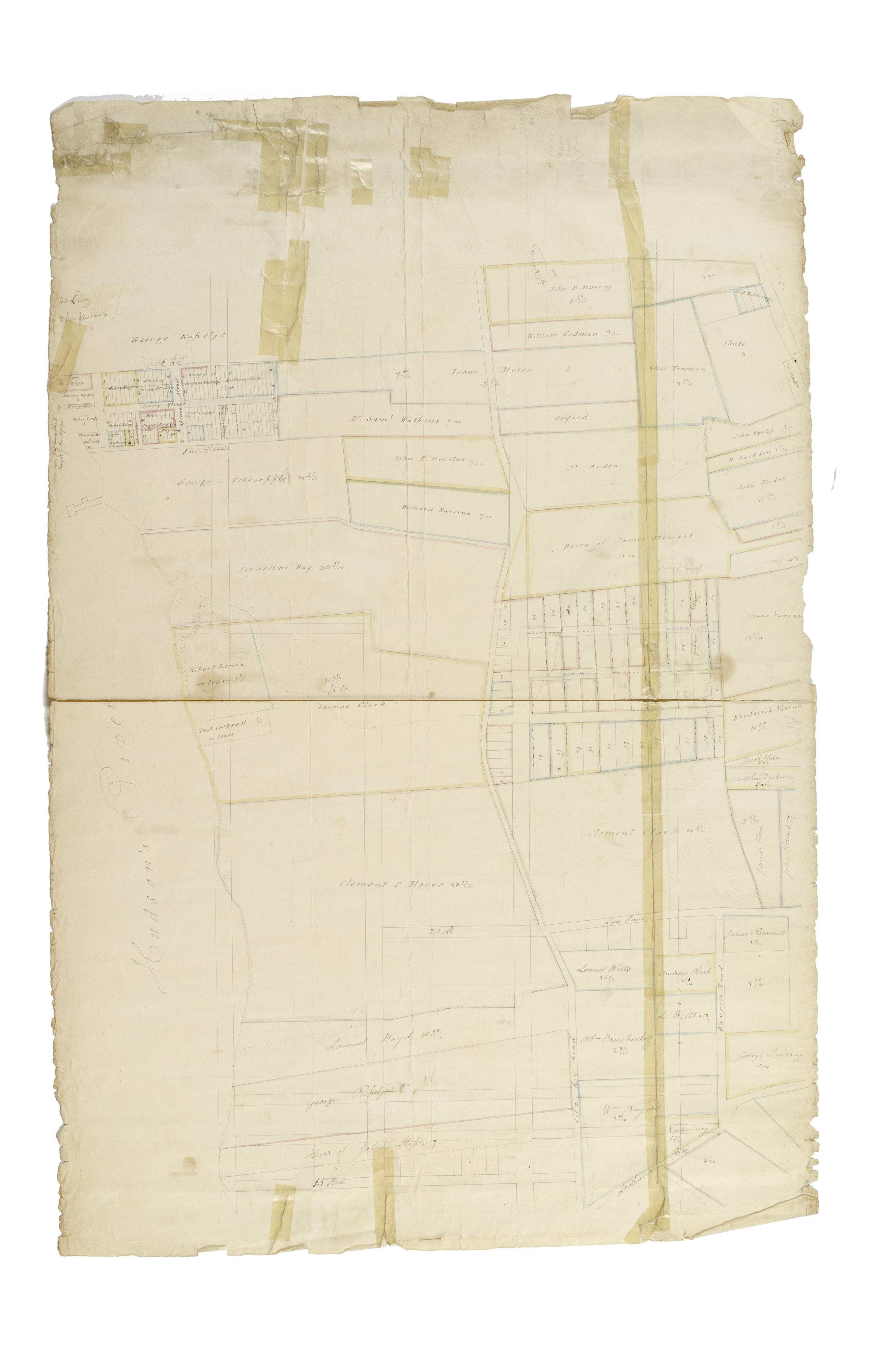
Still Image [Map of the area later bounded by 35th and 57th Streets, 7th and 11th Avenues, Manhattan, New York, N.Y.]. Scale [ca. 1:2,450]. Cadastral map. Shows property lines and owners' names, some existing roads and projected streets. Shows relief by hachures. Pen-and-ink, watercolor on paper. Annotations in a later hand on the recto of this sheet give the number 7. The map on recto of this sheet belongs to the same series and is separately cataloged under the title, [Map of the area later bounded by 30th and 53rd Streets, the East River and 5th Avenue, Manhattan, New York, N.Y.]. View Item
Still Image [Map of the area later bounded by 208th and 228th Streets, the Harlem and Hudson Rivers, Manhattan, New York, N.Y.]. Scale [ca. 1:2,450]. Cadastral map. Shows property lines and owners' names, some existing roads and projected streets. Shows relief by hachures. Pen-and-ink, watercolor on paper. Annotations in a later hand on the recto of this sheet give the number 25. The map on recto of this sheet belongs to the same series and is separately cataloged under the title, [Map of the area later bounded by 196th and 212th Streets, the Harlem and Hudson Rivers, Manhattan, New York, N.Y.]. View Item
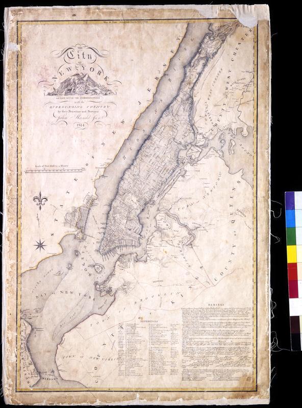
Still Image The City of New York as laid out by the Commissioners with the surrounding country / by their secretary and surveyor John Randel, Junr. Street planning map. Covers all of Manhattan Island (New York, N.Y.) and substantial parts of adjacent counties in New York and New Jersey. Shows existing and proposed streets; also buildings and other structures, streams and other wetlands, political boundaries. Includes extensive "REMARKS," also a key to New York City buildings. Pen-and-ink, watercolor on paper. Shows relief by hachures. Imperfect: lacking 4 x 9 and 2 x 5 cm. upper right corner, 2 x 2 cm. upper left side. References: Cohen, Paul E. and Robert T. Augustyn. Manhattan in Maps. NY: Rizzoli, 1997, p. 106ff; Stokes, I.N. Phelps. View Item
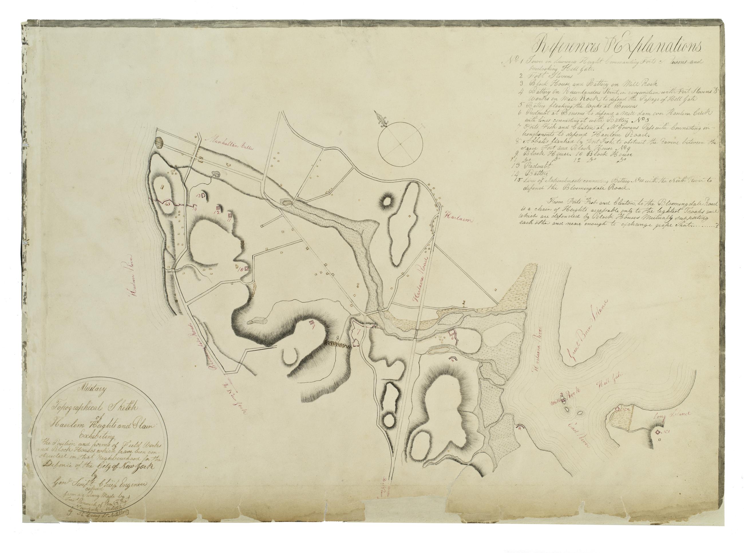
Still Image Military topographical sketch of Haerlem Heights and plain, exhibiting the position and forms of field works and block houses which have been constructed in that neghbourhood for the defence of the City of New York by Gen'l Swift, Chief Engineer / copied This manuscript map of Harlem is thought to have been drawn under the direction of James Renwick, whose son and namesake became a famous architect, for the Committee of Defense during the War of 1812. It includes a view of the Hudson River in the inset at the upper right. Military map. Covers the area later bounded by 85th and 135th Streets, Hell Gate and the Hudson River, Manhattan, New York (N.Y.). Shows fortifications, including batteries and redoubts. Also shows buildings, roads, streams and bridges. Relief shown by hachures, depths shown by form lines. View Item
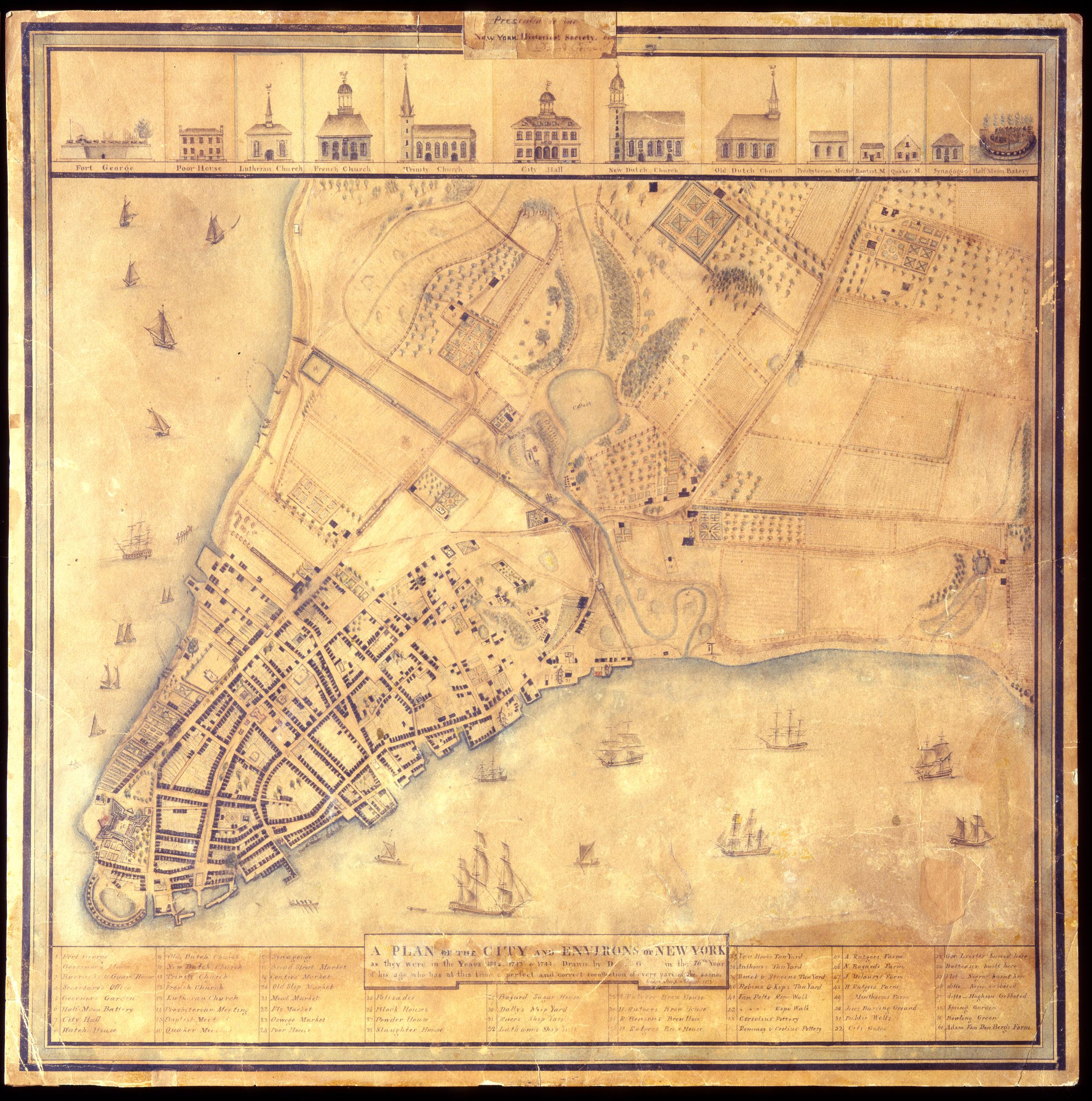
Still Image A Plan of the city and environs of New York as they were in the years 1742. 1743. & 1744. / drawn by D--- G--- in the 76th year of his age, who has at this time a perfect and correct recollection of every part of the same. Cedar Street. August 1813. David Grim's map of prerevolutionary Manhattan. Historical map. Covers Manhattan Island south of modern 14th Street, New York (N.Y.). Shows buildings and many other urban features; also shows natural and agricultural features. Date of ms. 1813 Aug. Date of situation between 1742 and 1744. On label pasted at top center: "Presented to the New York Historical Society by David Grim". Pen-and-ink (black and color), watercolor, pencil on paper. Selected material shown pictorially. Includes index. References: Cohen, Paul E. and Robert T. Augustyn. Manhattan in Maps, p. 62-63; Stokes, I.N. Phelps. View Item
Still Image This map of the City of New York and island of Manhattan as laid out by the commissioners appointed by the legislature April 3, 1807 is respectfully dedicated to the mayor, alderman and commonality thereof / by their most obedient servant Wm. Bridges ; en Photolithographic reproduction of the William Bridges map of New York. Street planning map. Covers the entire island of Manhattan, New York (N.Y.) Shows some buildings. Also shows landforms and streams. Shows relief by shading. Derived from a manuscript draft by John Randel--cf. Cohen and Augustyn, op. cit. "Filed April 1st 1811." Certified by the commissioners. Ink, color wash. No watermark. Includes index. References: I.N.P. Stokes, Iconography of Manhattan Island (1915-1928), Vol. III, page 549; Daniel C. Haskell, Manhattan Maps (1931), 655; Cohen, Paul E. and Robert T. Augustyn. View Item
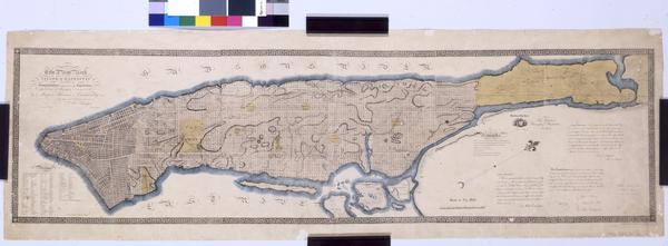
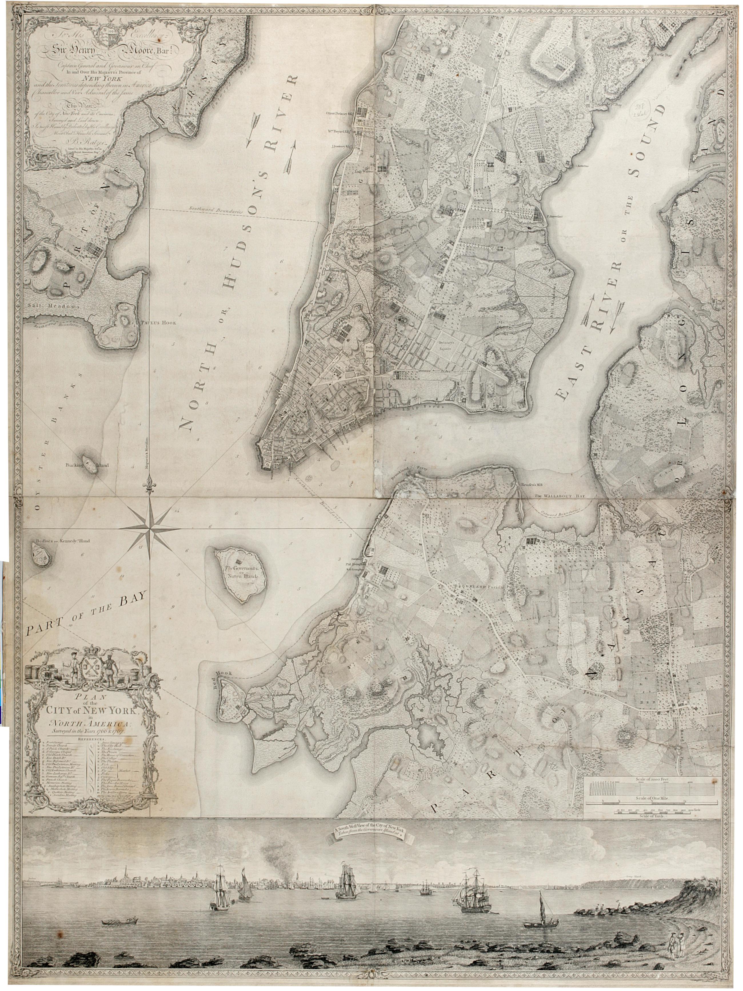
Still Image Plan of the city of New York in North America : surveyed in the years 1766 & 1767. The Ratzer map of New York City. First state, 1770. Covers part of modern New York City: Manhattan below the later 60th Street and Brooklyn north of the later 30th Street and west of the later Union Avenue; also a small part of modern Queens and of Jersey City, New Jersey. Shows built up and cultivated areas, streets and rural roads, some buildings, piers. Also shows streams, ponds and wetlands. Shows relief by hachures. Shows depths by soundings. Dedication at upper left: "To His Excellency Sir Henry Moore, Bart. View Item
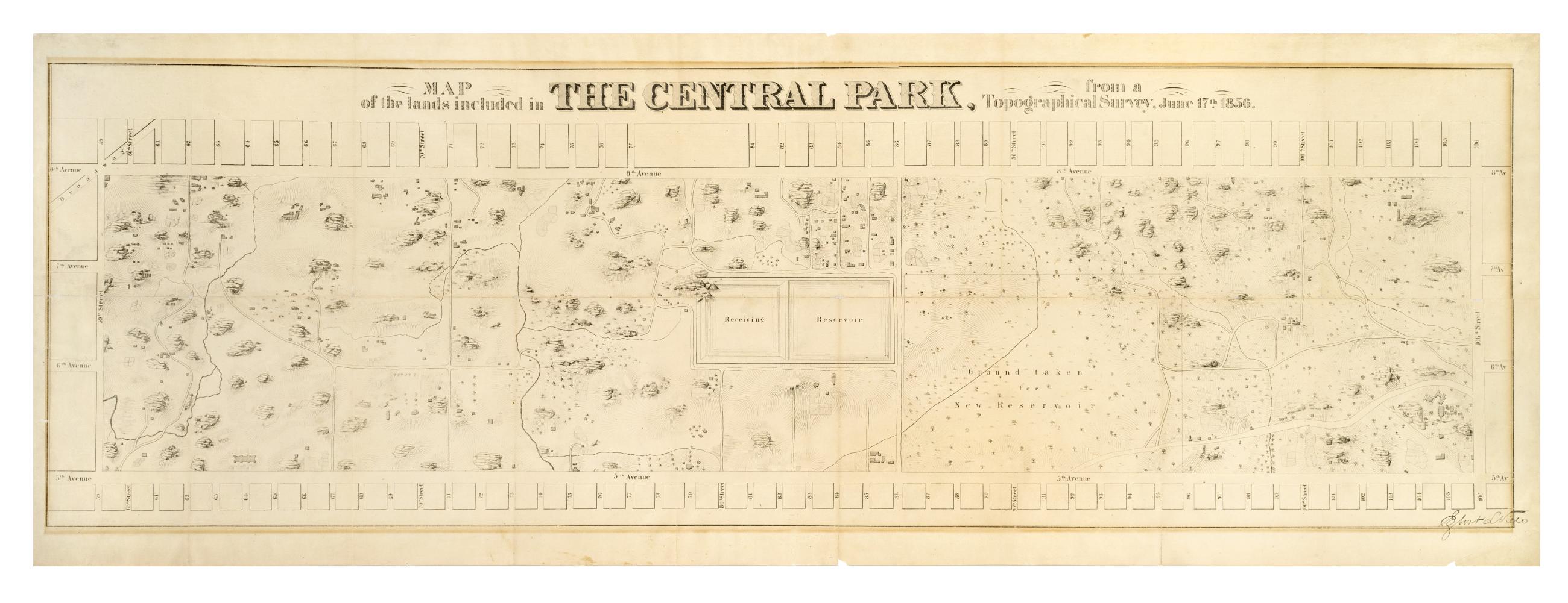
Still Image Map of the lands included in the Central Park, from a topographical survey, June 17th 1856 The Egbert L. Viele map of Central Park. Covers the area later bounded by 59th and 106th Streets, 5th Avenue and Central Park West, Manhattan, New York (N.Y.). Shows rock outcrops, buildings, reservoir, existing roads. Also shows landforms and streams. Shows relief by hachures. Oriented with north to right of sheet. "Engr. by Ferd. Mayer & Co." on companion map. From First Annual Report of the Board of Commissioners of the Central Park, January 1857. View Item
Image Collection 29 Items John Randel's Cadastral map of Manhattan, approximately 1815 This cadastral map of Manhattan in 26 sections on 13 sheets appears to be a draft of another map printed in Sackersdorff, Otto. Maps of farms, commonly called the Blue Book 1815 (New York: 1868). The map shows property lines and owners' names, some existing roads and projected streets, and shows relief by hachures. Pen-and-ink, watercolor on paper. Sackersdorff gives the date of the manuscript map as circa 1815. Attributed to Randel by the cataloger; for provenance, see Stokes, I.N.P. Iconography of Manhattan Island, v. 3, p. 565. View Collection