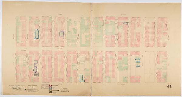
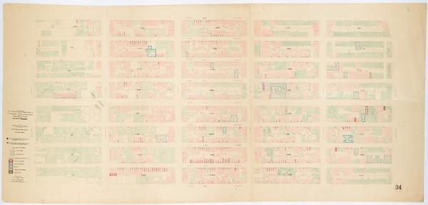
Still Image Map showing over-crowding of the buildings on the lots and the consequent lack of light and air space also strong-holds of poverty and agencies for betterment in the tenement house district bounded by 3rd Avenue, 1st Avenue, 98th, 86th Streets / prepared Scale [ca. 1:650]. Oriented with north to the upper right of sheet. View Item
Still Image Map showing over-crowding of the buildings on the lots and the consequent lack of light and air space also strong-holds of poverty and agencies for betterment in the tenement house district bounded by 12th Street, 5th Street, Avenue A, East River / prepar Scale [ca. 1:650]. View Item
Still Image Map showing over-crowding of the buildings on the lots and the consequent lack of light and air space also strong-holds of poverty and agencies for betterment in the tenement house district bounded by 12th Ave., 10th Ave, 70th, 57th Streets / prepared for Scale [ca. 1:650]. Oriented with north to upper right of sheet. View Item
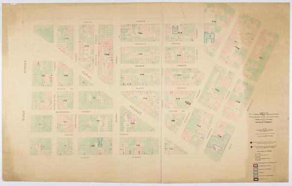
Still Image Map showing over-crowding of the buildings on the lots and the consequent lack of light and air space also strong-holds of poverty and agencies for betterment in the tenement house district bounded by West Street, West Broadway, W. Houston, Spring Streets Scale [ca. 1:650]. View Item
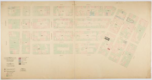
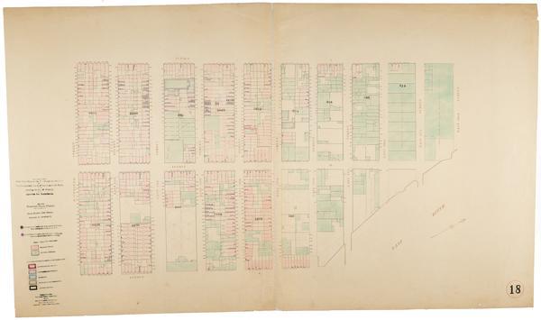
Still Image Map showing over-crowding of the buildings on the lots and the consequent lack of light and air space also strong-holds of poverty and agencies for betterment in the tenement house district bounded by 11th Avenue, 6th Avenue, West 17th Street, West 14th S Scale [ca. 1:650]. View Item
Still Image Map showing over-crowding of the buildings on the lots and the consequent lack of light and air space also strong-holds of poverty and agencies for betterment in the tenement house district bounded by 12th & 13th Ave., 7th Avenue, 46th, 38th Streets / pre Scale [ca. 1:650]. View Item
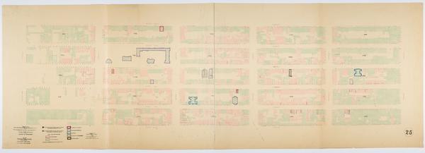
Still Image Map showing over-crowding of the buildings on the lots and the consequent lack of light and air space also strong-holds of poverty and agencies for betterment in the tenement house district bounded by 22nd Street, 12th Street, Avenue A, Avenue C / prepare Scale [ca. 1:650]. Oriented with north to the upper right of sheet. View Item
Still Image Map showing over-crowding of the buildings on the lots and the consequent lack of light and air space also strong-holds of poverty and agencies for betterment in the tenement house district bounded by 22nd Street, 17th Street, 11th Avenue, 6th Avenue / pr Scale [ca. 1:650]. View Item
Still Image Map showing over-crowding of the buildings on the lots and the consequent lack of light and air space also strong-holds of poverty and agencies for betterment in the tenement house district bounded by West Street, West Broadway, Spring, Laight Streets / p Scale [ca. 1:650]. View Item
Still Image Map showing over-crowding of the buildings on the lots and the consequent lack of light and air space also strong-holds of poverty and agencies for betterment in the tenement house district bounded by 1st Avenue, East River, 82nd, 72nd Streets / prepared Scale [ca. 1:650]. View Item
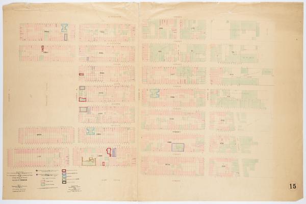
Still Image Map showing over-crowding of the buildings on the lots and the consequent lack of light and air space also strong-holds of poverty and agencies for betterment in the tenement house district bounded by East Houston, Rivington Streets, Bowery, Willett Stree Scale [ca. 1:650]. View Item
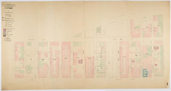
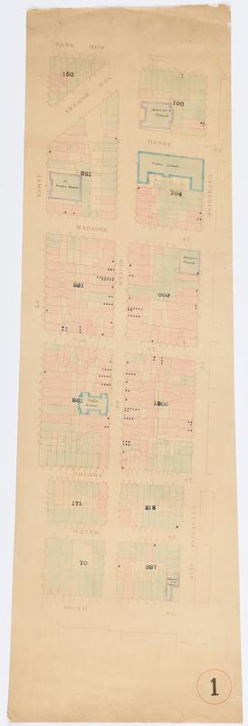
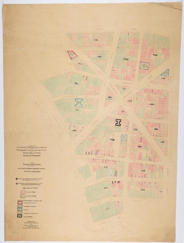
Still Image Map showing over-crowding of the buildings on the lots and the consequent lack of light and air space also strong-holds of poverty and agencies for betterment in the tenement house district bounded by Dover and Frankfort, Catharine Streets, Park Row, Sout Scale [ca. 1:650]. View Item
Still Image Map showing over-crowding of the buildings on the lots and the consequent lack of light and air space also strong-holds of poverty and agencies for betterment in the tenement house district bounded by Dover and Frankfort, Catharine Streets, Park Row, Sout Scale [ca. 1:650]. View Item
Name 136556-Service File File 136556-original-file.jp2 (10.13 MB) MIME type image/jp2 Media Use Service File Media of Map showing over-crowding of the buildings on the lots and the consequent lack of light and air space also strong-holds of poverty and agencies for betterment in the tenement house district bounded by Dover and Frankfort, Catharine Streets, Park Row, Sout File size 10626195 Still Image 2 Items Map showing over-crowding of the buildings on the lots and the consequent lack of light and air space also strong-holds of poverty and agencies for betterment in the tenement house district bounded by Dover and Frankfort, Catharine Streets, Park Row, Sout Scale [ca. 1:650]. View Item
Name 136556-Service File File 136556-original-file.jp2 (10.13 MB) MIME type image/jp2 Media Use Service File Media of Map showing over-crowding of the buildings on the lots and the consequent lack of light and air space also strong-holds of poverty and agencies for betterment in the tenement house district bounded by Dover and Frankfort, Catharine Streets, Park Row, Sout File size 10626195
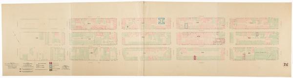
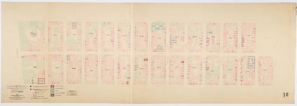
Name 137199-Service File File 137199-original-file.jp2 (14.54 MB) MIME type image/jp2 Media Use Service File Media of Map showing over-crowding of buildings on lots and consequent lack of light and air space also the prevalence of tuberculosis, typhoid fever, scarlet fever and diphtheria in the tenement house district bounded by 3rd Ave., East River, 110th, 98th Streets File size 15241313 Collection 2 Items Charity Organization Society of the City of New York, Tenement House Committee Strong-holds of poverty and Prevalence of disease maps, 1899 These 89 maps, hand-drawn and hand-colored, were created in 1899: under the leadership of Lawrence Veiller in conjunction with the Charity Organization Society of New York for display at the Tenement House Exhibition, held in Manhattan in February 1900. They depict neighborhoods throughout Manhattan, from the Battery to Harlem, in two series: "Strong-holds of poverty" and "Prevalence of disease." Colored dots on the first series indicate the number of families requesting charitable assistance. View Collection
Name 137199-Service File File 137199-original-file.jp2 (14.54 MB) MIME type image/jp2 Media Use Service File Media of Map showing over-crowding of buildings on lots and consequent lack of light and air space also the prevalence of tuberculosis, typhoid fever, scarlet fever and diphtheria in the tenement house district bounded by 3rd Ave., East River, 110th, 98th Streets File size 15241313