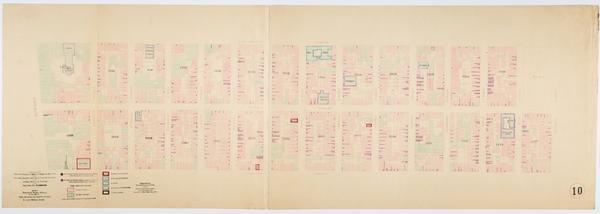
Still Image Map showing over-crowding of the buildings on the lots and the consequent lack of light and air space also strong-holds of poverty and agencies for betterment in the tenement house district bounded by 22nd Street, 12th Street, Avenue A, Avenue C / prepare Scale [ca. 1:650]. Oriented with north to the upper right of sheet. View Item
Still Image Map showing over-crowding of the buildings on the lots and the consequent lack of light and air space also strong-holds of poverty and agencies for betterment in the tenement house district bounded by 17th Street, 12th Street, Avenue C, East River / prepa Scale [ca. 1:650]. Oriented with north to bottom of sheet. View Item
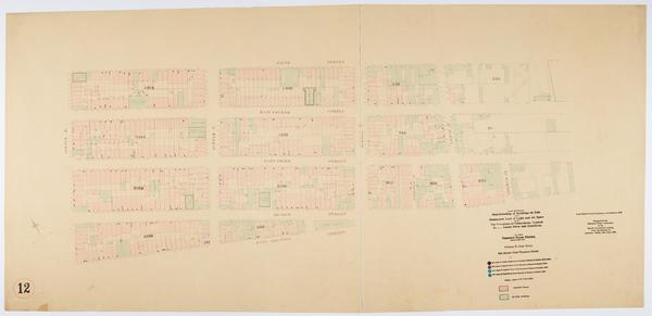
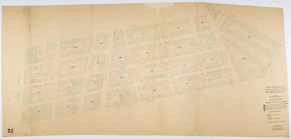
Still Image Map showing over-crowding of the buildings on the lots and the consequent lack of light and air space also strong-holds of poverty and agencies for betterment in the tenement house district bounded by 22nd Street, 17th Street, 11th Avenue, 6th Avenue / pr Scale [ca. 1:650]. View Item
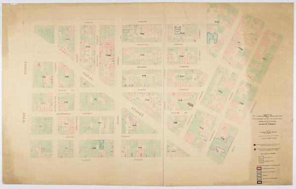
Still Image Map showing over-crowding of the buildings on the lots and the consequent lack of light and air space also strong-holds of poverty and agencies for betterment in the tenement house district bounded by West Street, West Broadway, Spring, Laight Streets / p Scale [ca. 1:650]. View Item
Still Image Map showing over-crowding of the buildings on the lots and the consequent lack of light and air space also strong-holds of poverty and agencies for betterment in the tenement house district bounded by 1st Avenue, East River, 82nd, 72nd Streets / prepared Scale [ca. 1:650]. View Item
Still Image Map showing over-crowding of the buildings on the lots and the consequent lack of light and air space also strong-holds of poverty and agencies for betterment in the tenement house district bounded by East Houston, Rivington Streets, Bowery, Willett Stree Scale [ca. 1:650]. View Item
Still Image Map showing over-crowding of buildings on lots and consequent lack of light and air space also the prevalence of tuberculosis, typhoid fever, scarlet fever and diphtheria in the tenement house district bounded by 3rd Ave., East River, 110th, 98th Streets Scale [ca. 1:650]. Oriented with north to upper right of sheet. View Item
Still Image Map showing over-crowding of buildings on lots and consequent lack of light and air space also the prevalence of tuberculosis, typhoid fever, scarlet fever and diphtheria in the tenement house district bounded by 3rd Avenue, 1st Avenue, 86th, 72nd Streets Scale [ca. 1:650]. Oriented with north to the upper right of sheet. View Item
Still Image Map showing over-crowding of buildings on lots and consequent lack of light and air space also the prevalence of tuberculosis, typhoid fever, scarlet fever and diphtheria in the tenement house district bounded by 3rd Avenue, 1st Avenue, 98th, 86th Streets Scale [ca. 1:650]. Oriented with north to the upper right of sheet. View Item
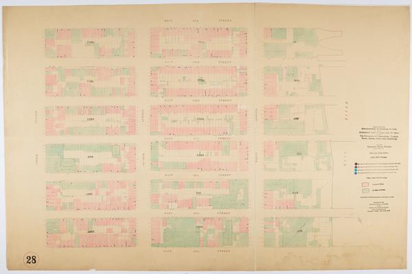
Still Image Map showing over-crowding of buildings on lots and consequent lack of light and air space also the prevalence of tuberculosis, typhoid fever, scarlet fever and diphtheria in the tenement house district bounded by 3rd Avenue, Avenue A, 22nd Street, 17th St Scale [ca. 1:650] View Item
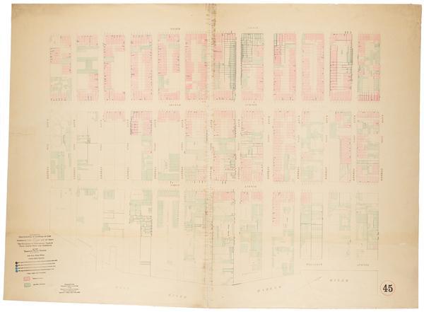
Still Image Map showing over-crowding of buildings on lots and consequent lack of light and air space also the prevalence of tuberculosis, typhoid fever, scarlet fever and diphtheria in the tenement house district bounded by 3rd Avenue, 1st Avenue, 130th, 110th Sts. Scale [ca. 1:650]. Oriented with north to the upper right of sheet. View Item
Still Image Map showing over-crowding of buildings on lots and consequent lack of light and air space also the prevalence of tuberculosis, typhoid fever, scarlet fever and diphtheria in the tenement house district bounded by Avenue B, East River, 5th Street, East Hou Scale [ca. 1:650] View Item
Still Image Map showing over-crowding of buildings on lots and consequent lack of light and air space also the prevalence of tuberculosis, typhoid fever, scarlet fever and diphtheria in the tenement house district bounded by 12th & 13th Ave, 7th Avenue, 52nd, 46th St Scale [ca. 1:650] View Item
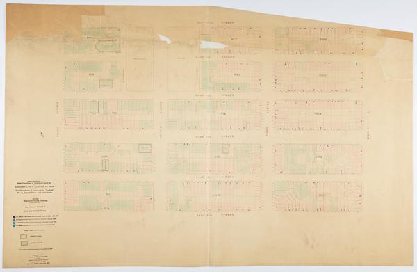
Still Image Map showing over-crowding of buildings on lots and consequent lack of light and air space also the prevalence of tuberculosis, typhoid fever, scarlet fever and diphtheria in the tenement house district bounded by West Street, 6th Avenue, West 12th & Bank Scale [ca. 1:650] View Item
Still Image Map showing over-crowding of buildings on lots and consequent lack of light and air space also the prevalence of tuberculosis, typhoid fever, scarlet fever and diphtheria in the tenement house district bounded by Bowery, Willett Street, East Houston, Rivi Scale [ca. 1:650] View Item
Still Image Map showing over-crowding of buildings on lots and consequent lack of light and air space also the prevalence of tuberculosis, typhoid fever, scarlet fever and diphtheria in the tenement house district bounded by 3rd Avenue, 1st Avenue, 72nd St., 62nd Str Scale [ca. 1:650] View Item
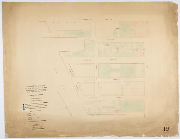
Still Image Map showing over-crowding of buildings on lots and consequent lack of light and air space also the prevalence of tuberculosis, typhoid fever, scarlet fever and diphtheria in the tenement house district bounded by Avenue A, East River, 12th Street, 5th Str Scale [ca. 1:650] View Item
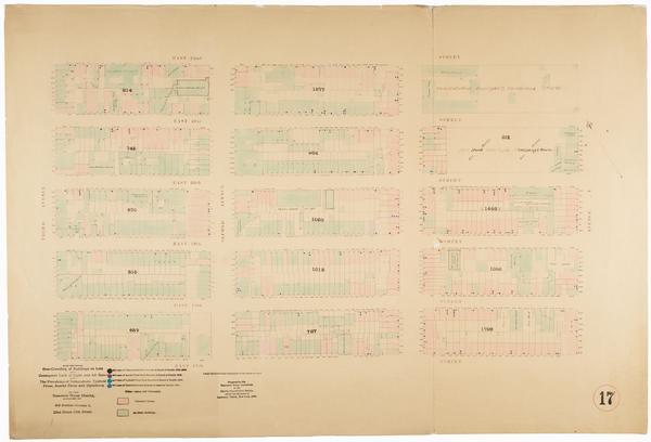
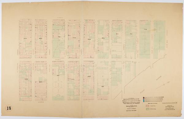
Still Image Map showing over-crowding of buildings on lots and consequent lack of light and air space also the prevalence of tuberculosis, typhoid fever, scarlet fever and diphtheria in the tenement house district bounded by Avenue A, Avenue C, 22nd Street, 12th Stre Scale [ca. 1:650]. Oriented with north to upper right of sheet. View Item
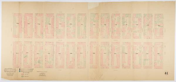
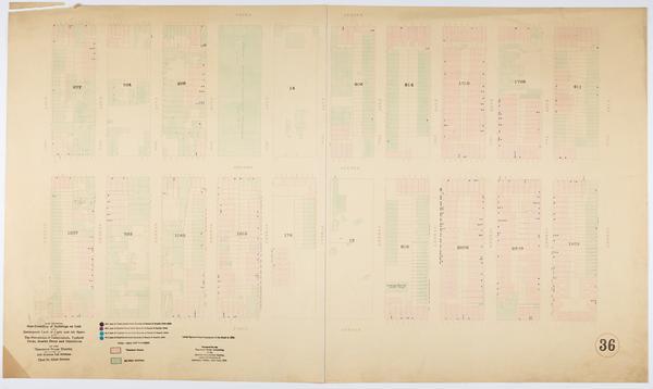
Still Image Map showing over-crowding of buildings on lots and consequent lack of light and air space also the prevalence of tuberculosis, typhoid fever, scarlet fever and diphtheria in the tenement house district bounded by 3rd Ave., East River, 46th, 40th Streets / Scale [ca. 1:650] View Item
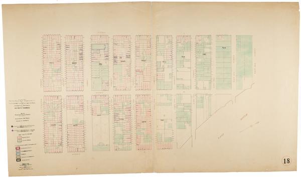
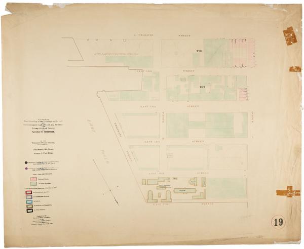
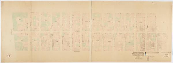
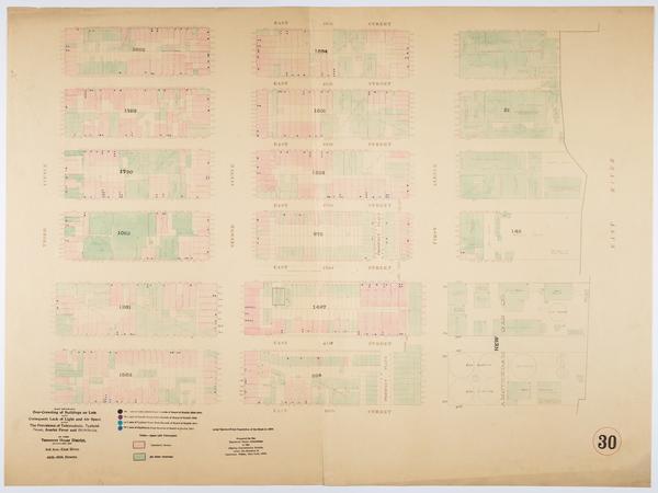
Still Image Map showing over-crowding of buildings on lots and consequent lack of light and air space also the prevalence of tuberculosis, typhoid fever, scarlet fever and diphtheria in the tenement house district bounded by Avenue C, East River, 17th Street, 12th St Scale [ca. 1:650]. Oriented with north to lower right of sheet. View Item
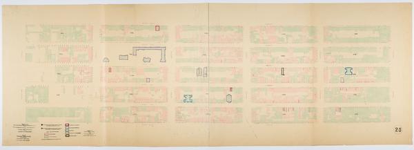
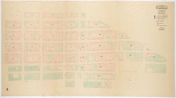
Still Image Map showing over-crowding of buildings on lots and consequent lack of light and air space also the prevalence of tuberculosis, typhoid fever, scarlet fever and diphtheria in the tenement house district bounded by Rutgers, Corlears Street, Division Street, Scale [ca. 1:650] View Item
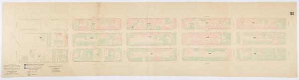
Still Image Map showing over-crowding of buildings on lots and consequent lack of light and air space also the prevalence of tuberculosis, typhoid fever, scarlet fever and diphtheria in the tenement house district bounded by 12th & 13th Ave., 7th Avenue, 46th, 38th S Scale [ca. 1:650] View Item
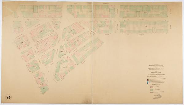
Still Image Map showing over-crowding of buildings on lots and consequent lack of light and air space also the prevalence of tuberculosis, typhoid fever, scarlet fever and diphtheria in the tenement house district bounded by 11th Avenue, 6th Avenue, West 22nd St., We Scale [ca. 1:650] View Item
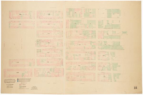
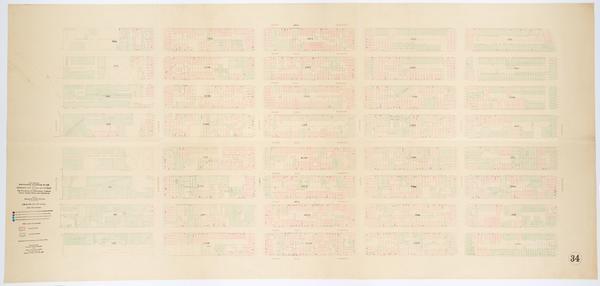
Still Image Map showing over-crowding of buildings on lots and consequent lack of light and air space also the prevalence of tuberculosis, typhoid fever, scarlet fever and diphtheria in the tenement house district bounded by 3rd Ave., East River, 34th, 28th Streets / Scale [ca. 1:650] View Item
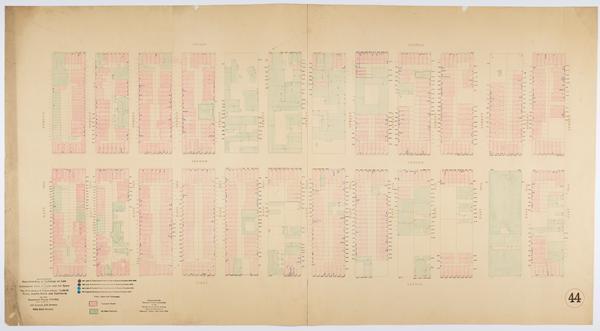
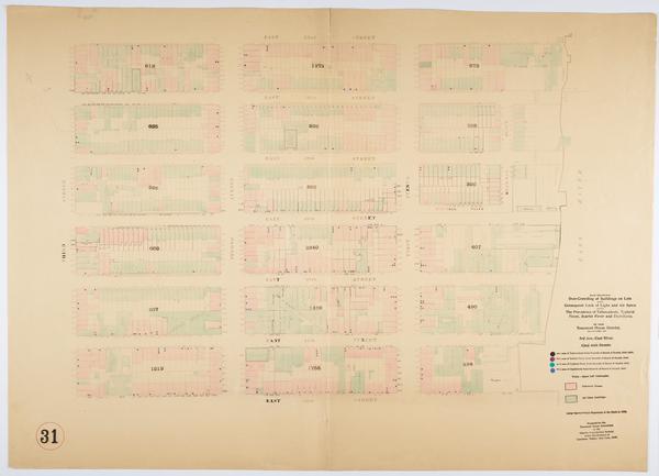
Still Image Map showing over-crowding of buildings on lots and consequent lack of light and air space also the prevalence of tuberculosis, typhoid fever, scarlet fever and diphtheria in the tenement house district bounded by 3rd Ave., East River, 52nd, 46th Streets / Scale [ca. 1:650] View Item
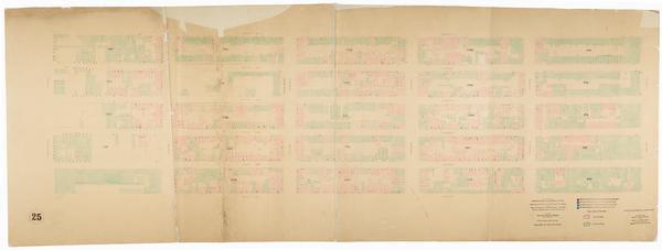
Still Image Map showing over-crowding of buildings on lots and consequent lack of light and air space also the prevalence of tuberculosis, typhoid fever, scarlet fever and diphtheria in the tenement house district bounded by 3rd Avenue, Avenue A, 17th Street, 12th St Scale [ca. 1:650] View Item
Still Image Map showing over-crowding of buildings on lots and consequent lack of light and air space also the prevalence of tuberculosis, typhoid fever, scarlet fever and diphtheria in the tenement house district bounded by West Street, 6th Avenue, West 10th Street, Scale [ca. 1:650] View Item
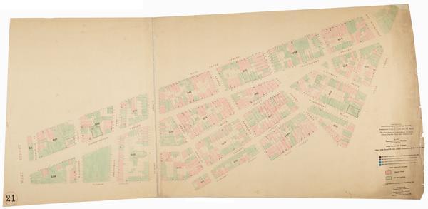
Still Image Map showing over-crowding of buildings on lots and consequent lack of light and air space also the prevalence of tuberculosis, typhoid fever, scarlet fever and diphtheria in the tenement house district bounded by West Street, Greenwich St. & 9th Avenue, W Scale [ca. 1:650]. Oriented with north to left of sheet. View Item
Still Image Map showing over-crowding of buildings on lots and consequent lack of light and air space also the prevalence of tuberculosis, typhoid fever, scarlet fever and diphtheria in the tenement house district bounded by 11th Avenue, 6th Avenue, West 17th Street, Scale [ca. 1:650] View Item
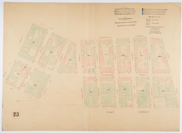
Still Image Map showing over-crowding of buildings on lots and consequent lack of light and air space also the prevalence of tuberculosis, typhoid fever, scarlet fever and diphtheria in the tenement house district bounded by Greenwich Street & 9th Avenue, 6th Avenue, Scale [ca. 1:650] View Item