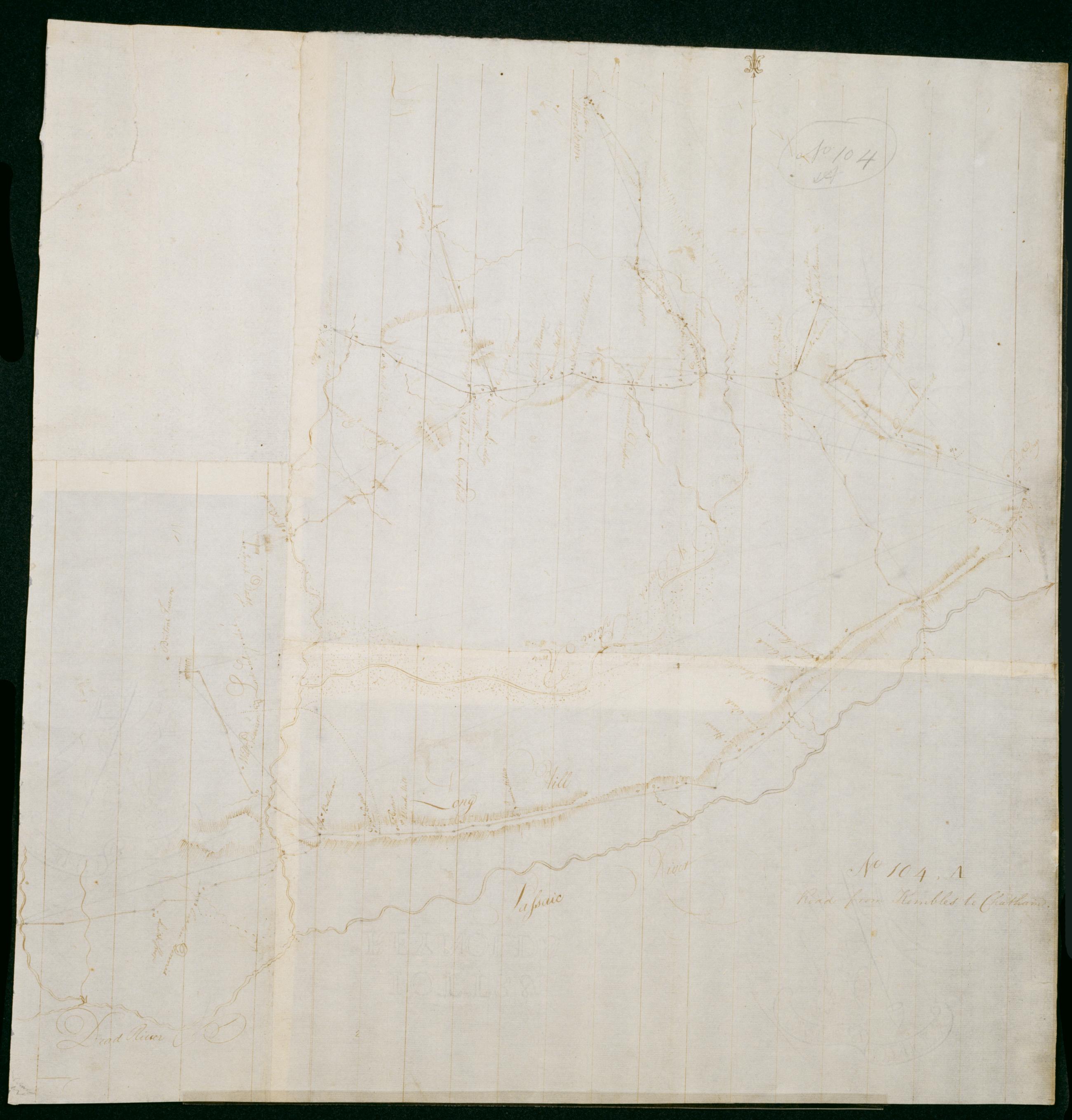
Cartographic Road from Kembles to Chatham. No 104, A / by Robert Erskine F.R.S. Geogr. A. U.S. and Assistants. Foxed, creased, frayed and abraded. Mounted on cloth, bound and cropped, disbound and silked by subsequent owners. Cleaned after removal of backings 1999; some fill remains. Sheathed in mylar. In pencil on recto: "No 104 A". Military topographic map. Covers the townships of Passaic and Morris in Morris County and of Bernard in Somerset County, New Jersey. Shows roads running through Chatham, Morristown, Logansville, Millington and Liberty Corner. Also shows buildings and owners' names, landforms and streams. Pen-and-ink, pencil on laid paper. Shows relief by hachures. View Item
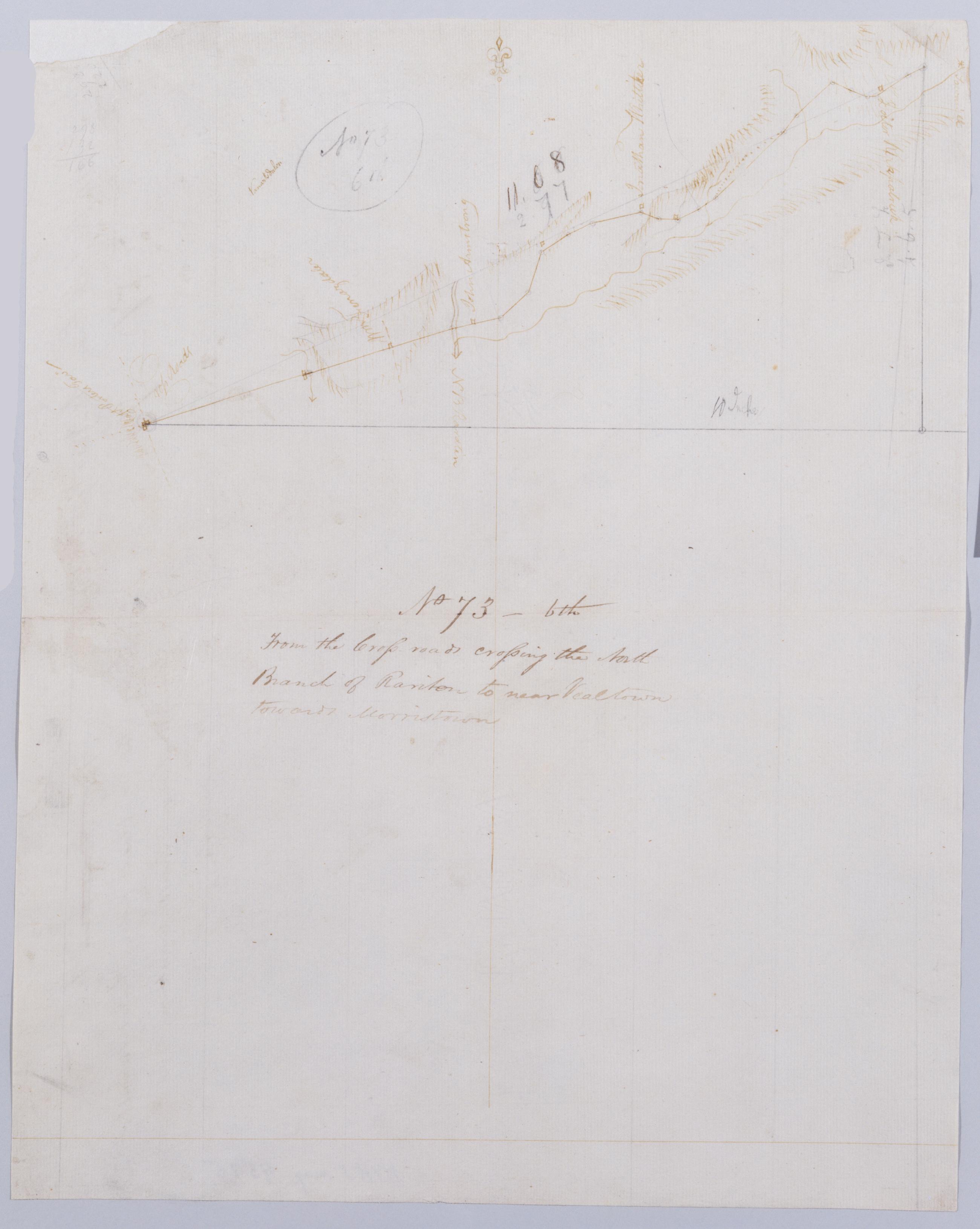
Cartographic From the Cross-roads crossing the North Branch of Rariton to near Vealtown towards Morristown. No 73, 6th / by Robert Erskine F.R.S. Geogr. A. U.S. and Assistants. Also in ink on verso: "Road from near Veal". Foxed, creased, torn, frayed and abraded. Mounted on cloth, bound and cropped, disbound and silked by subsequent owners. Cleaned after removal of backings 1999; some fill remains. Sheathed in mylar. In pencil on recto: "No 73 6th". Military topographic map. Covers the townships of Bedminster and Bernard in Somerset County, New Jersey. Shows roads running through Greater Crossroads, Bedminster and Far Hills. Also shows buildings and owners' names, landforms and streams. Pen-and-ink, pencil on laid paper. Shows relief by hachures. View Item
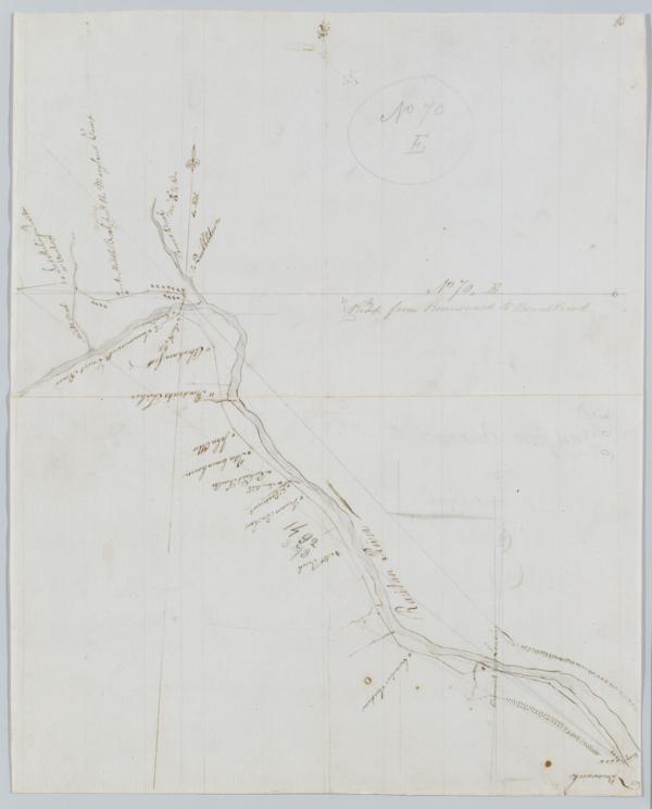
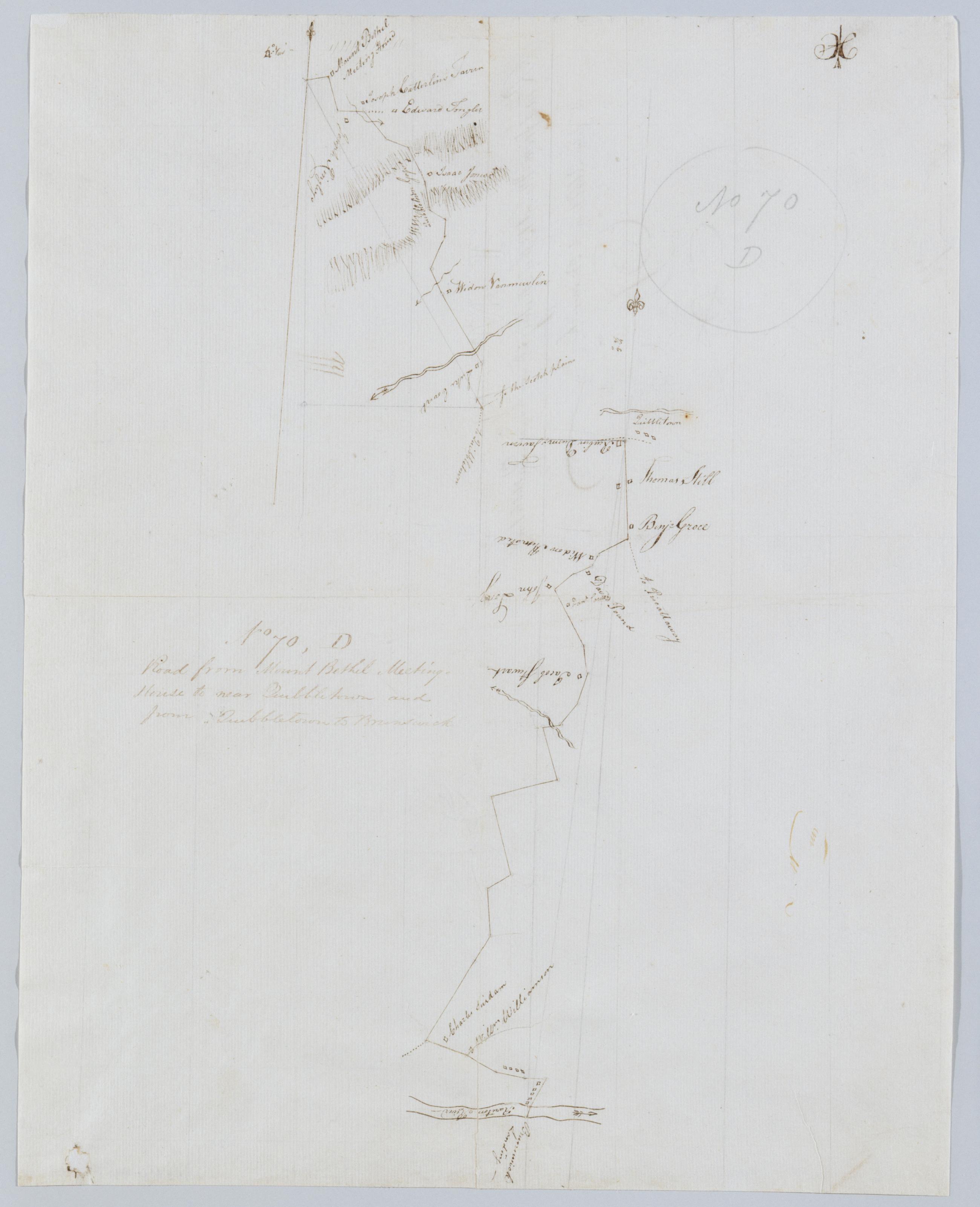
Cartographic Road from Mount Bethel Meeting House to near Quibbletown and from Quibbletown to Brunswick. No 70, D / by Robert Erskine F.R.S. Geogr. A. U.S. and Assistants. Foxed, creased and abraded. Mounted on cloth, bound and cropped, disbound and silked by subsequent owners. Cleaned after removal of backings 1999; some fill remains. Sheathed in mylar. Imperfect: lacking small piece at lower left corner. In pencil on recto: "No 70 D". Military topographic map. Covers the townships of Warren and North Plainfield in Somerset County and of Piscataway in Middlesex County, New Jersey. Shows roads running through Mt. Bethel, Newmarket, Newtown and New Brunswick. Also shows buildings and owners' names, landforms and streams. Pen-and-ink, pencil on laid paper. View Item
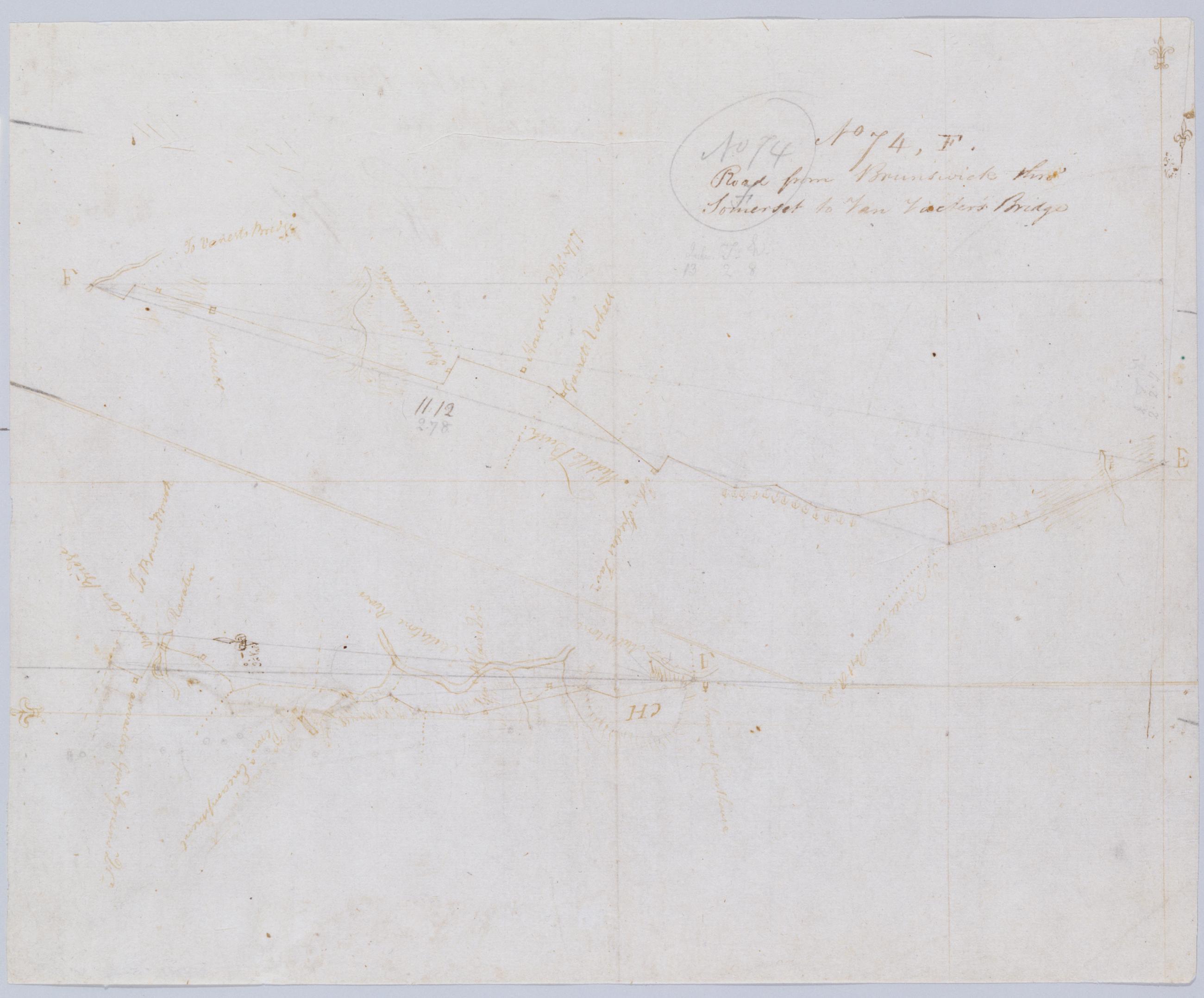
Cartographic Road from Brunswick thro' Somerset to Van Vacter's Bridge. No 74, F / by Robert Erskine F.R.S. Geogr. A. U.S. and Assistants. In pencil on recto: "No 74 F". Military topographic map. Covers the townships of Franklin and Hillsboro in Somerset County, New Jersey. Shows roads running through New Brunswick, Middlebush, East Millstone, Weston and Finderne. Also shows buildings and owners' names, landforms and streams. Pen-and-ink, pencil on laid paper. Shows relief by hachures. Soiled, creased, and abraded. Mounted on cloth, bound and cropped, disbound and silked by subsequent owners. Cleaned after removal of backings 1999; some fill remains. Sheathed in mylar. View Item
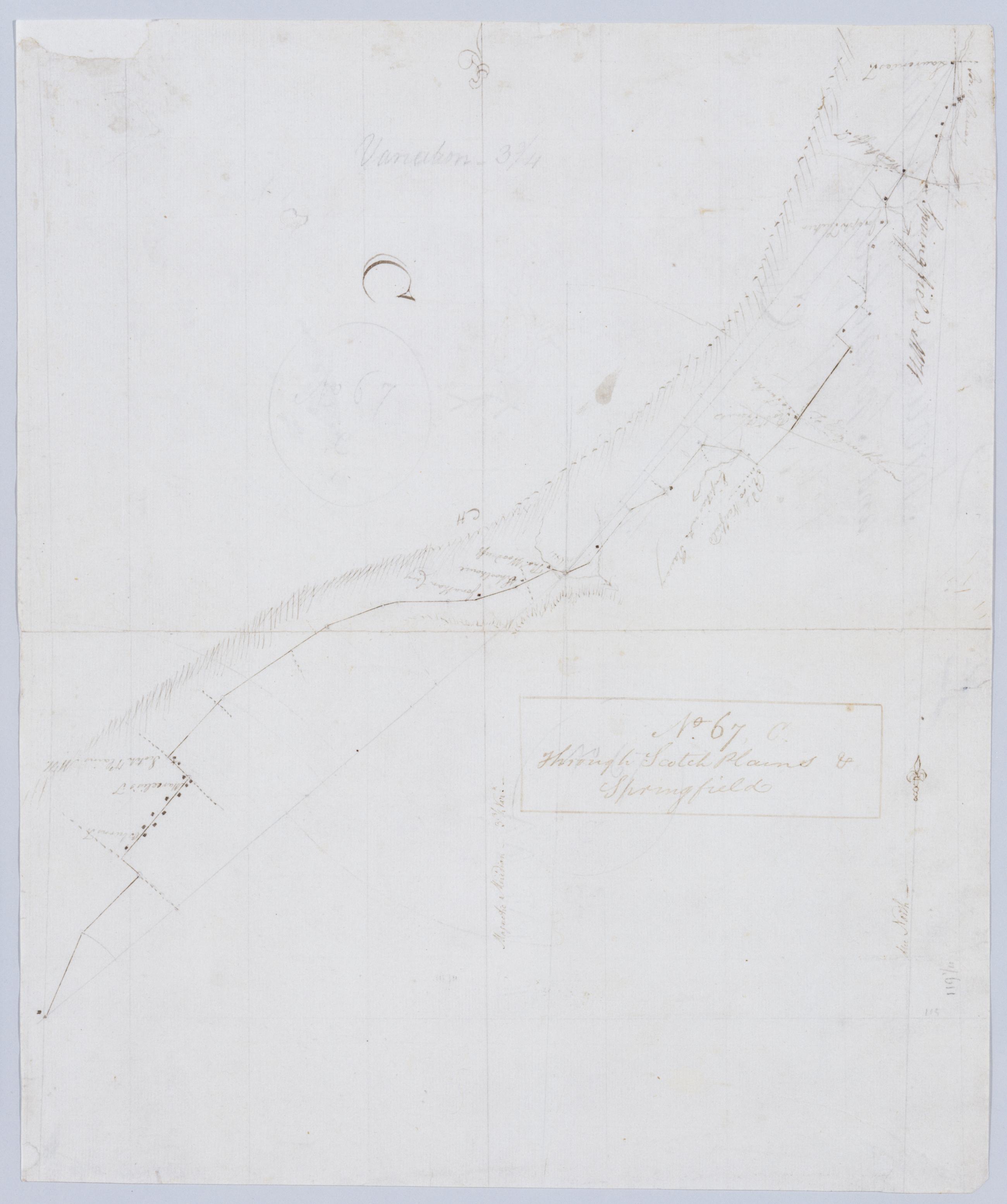
Cartographic Through Scotch Plains & Springfield. No 67, C / by Robert Erskine F.R.S. Geogr. A. U.S. and Assistants. In ink on recto: "C". In pencil on recto:"No 67 C". Military topographic map. Covers the townships of South Orange, Milburn and Union in Essex County and of Springfield, Westfield and Fanwood in Somerset County, New Jersey. Shows roads running though Springfield, Branch Mills, Locust Grove, Scotch Plains and Netherwood. Also shows buildings and owners' names, also landforms and streams. Pen-and-ink, pencil on laid paper. Shows relief by hachures. Stained, creased, frayed and abraded. Mounted on cloth, bound and cropped, disbound and silked by subsequent owners. View Item
Cartographic Road from Brunswick to Boundbrook. No 70, E / by Robert Erskine F.R.S. Geogr. A. U.S. and Assistants. In pencil on recto: "No 70 E". Military topographic map. Covers the townships of Bridgewater and Franklin in Somerset County and of Piscataway in Middlesex County, New Jersey. Shows roads running through Boundbrook, South Boundbrook and New Brunswick. Also shows buildings and owners' names, landforms and streams. Pen-and-ink, pencil on laid paper. Scale distorted in parts; varies between ca. 1:30,000 and ca. 1:40,000. Shows relief by hachures. Stained, foxed, creased and abraded. Mounted on cloth, bound and cropped, disbound and silked by subsequent owners. View Item
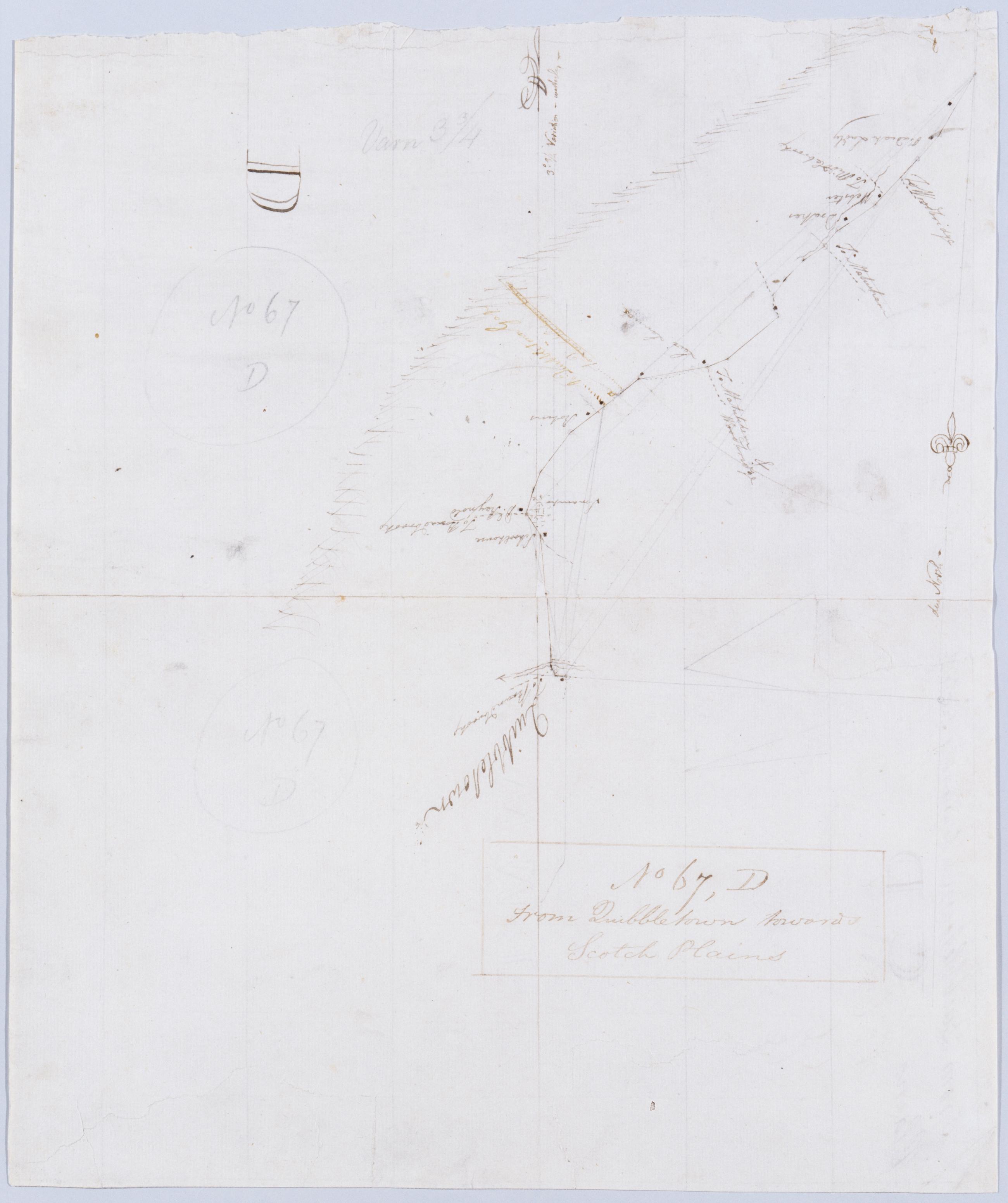
Cartographic From Quibbletown towards Scotch Plains. No 67, D / by Robert Erskine F.R.S. Geogr. A. U.S. and Assistants. In Erskine's handwriting, inked on verso after title: "No. 67 C [crossed-out] D CC CC No. 67 D". In ink on recto: "D". In pencil on recto:"No 67 D" (twice). Military topographic map. Covers the townships of Fanwood and Plainfield in Somerset County and of Piscataway in Middlesex County, New Jersey. Shows roads running through Sampton (formerly called Quibbletown) and Netherwood. Also shows buildings and owners' names, landforms and streams. Pen-and-ink, pencil on laid paper. Shows relief by hachures. Stained, creased, torn, frayed and abraded. View Item
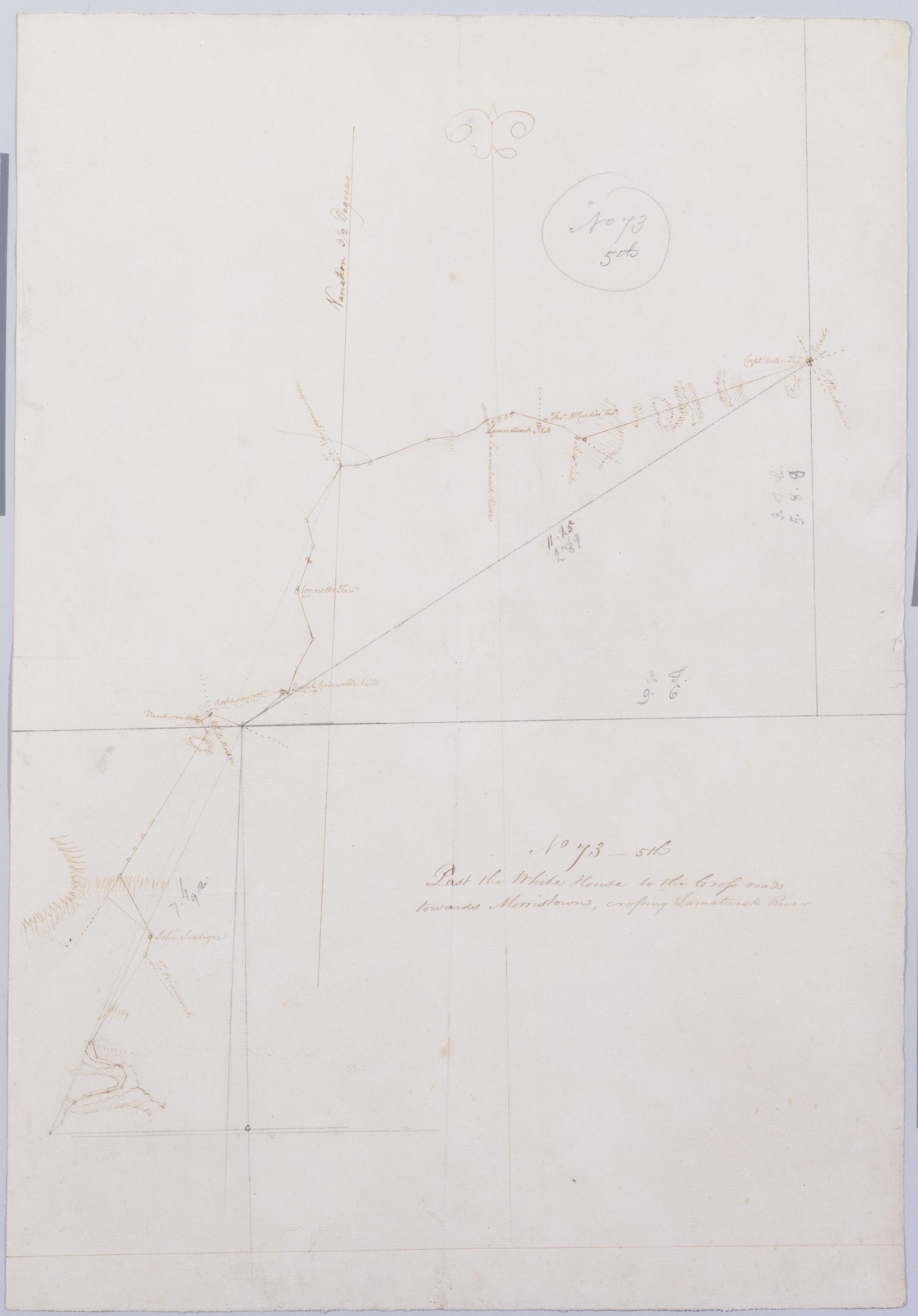
Cartographic Past the White House to the Cross roads towards Morristown, crossing Lamatunck River. No 73 - 5th / by Robert Erskine F.R.S. Geogr. A. U.S. and Assistants. Foxed, creased and abraded. Mounted on cloth, bound and cropped, disbound and silked by subsequent owners. Cleaned after removal of backings 1999; some fill remains. Sheathed in mylar. In pencil on recto: "No 73 5th". Military topographic map. Covers the townships of Bedminster in Somerset County and of Readington and Tewksbury in Hunterdon County, New Jersey. Shows roads running through White House, Lamington and Greater Crossroads. Also shows buildings and owners' names, landforms and streams. Pen-and-ink, pencil on laid paper. Shows relief by hachures. View Item
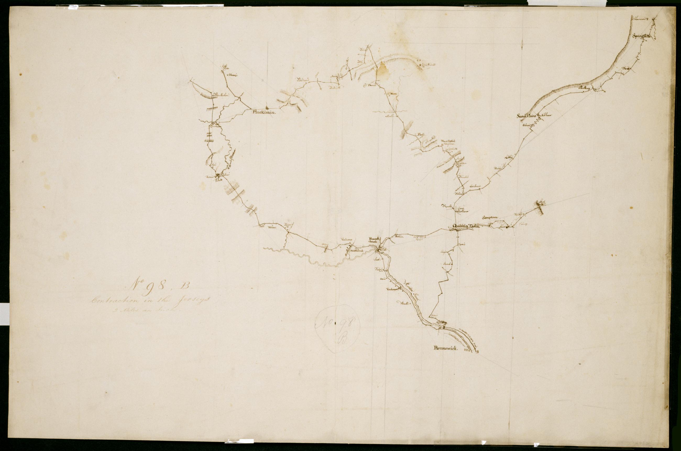
Cartographic Contraction in the Jerseys. No 98, B / Large Paper by Capt. Scull ; by Robert Erskine F.R.S. Geogr. A. U.S. and Assistants. Foxed, stained, soiled, creased, frayed and abraded. Mounted on cloth, bound and cropped, disbound and silked by subsequent owners. Cleaned after removal of backings 1999; some fill remains. Sheathed in mylar. In ink on verso "No. 98 B." In pencil on recto: "No. 98 B". Military topographic map. Covers parts of Middlesex, Somerset and Union counties in New Jersey. Also shows buildings and owners' names, landforms and streams. Pen-and-ink, pencil on laid paper. Scale as drawn 1 in. per mi. Shows relief by hachures. View Item
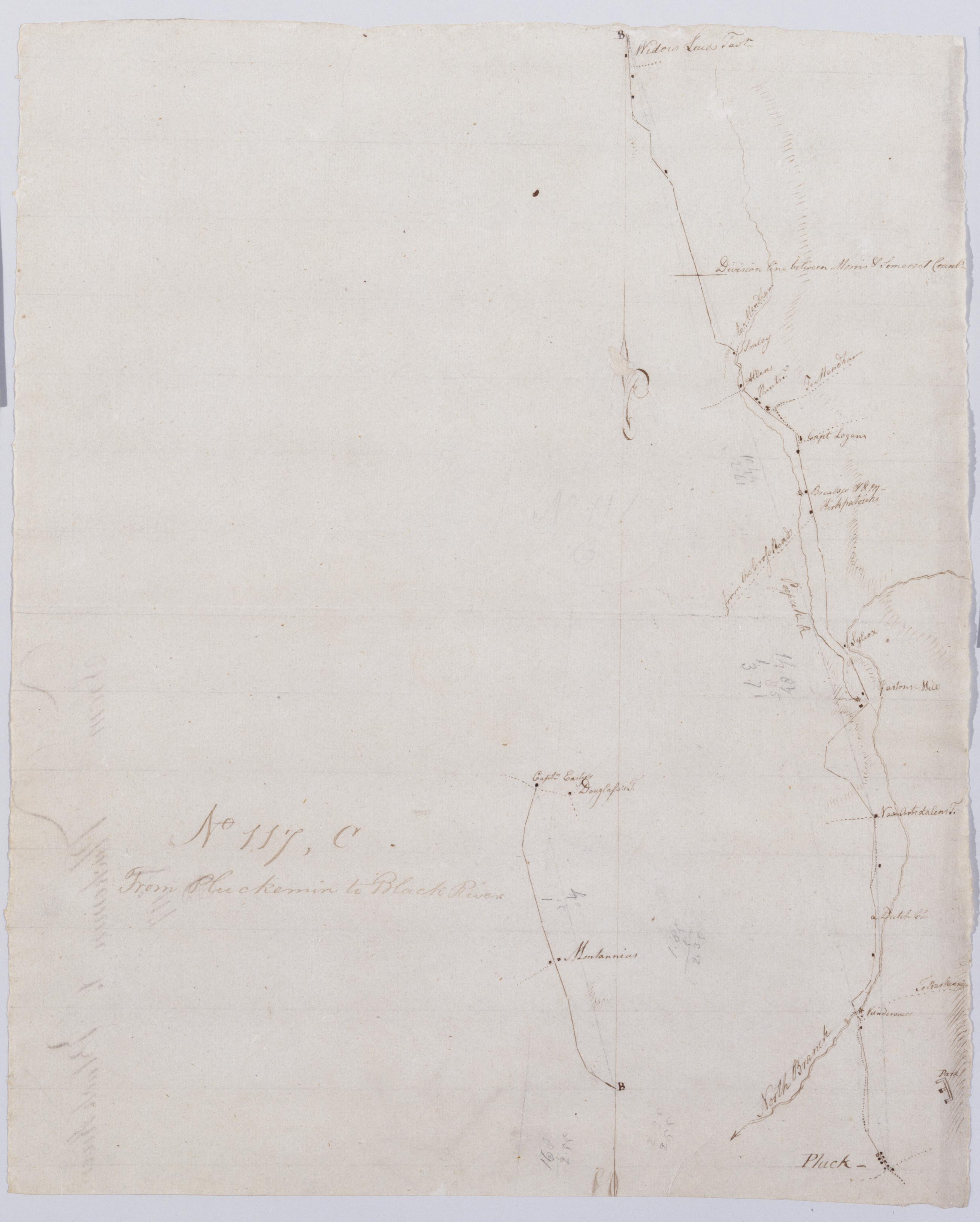
Cartographic From Pluckemin to Black River. No 117, C / by Robert Erskine F.R.S. Geogr. A. U.S. and Assistants. Drawing attributed to Simeon DeWitt, based on attribution made for sheet 117,A of series. In erased pencil on recto: "No 117 C". Military topographic map. Covers the townships of Chester in Morris County and of Bedminster in Somerset County, New Jersey. Shows roads running through Chester, Gladstone, Peapack, Bedminster and Pluckemin. Also shows buildings and owners' names, landforms and streams. Pen-and-ink, pencil on laid paper. Shows relief by hachures. Soiled, creased and abraded. Mounted on cloth, bound, disbound and silked by subsequent owners. View Item
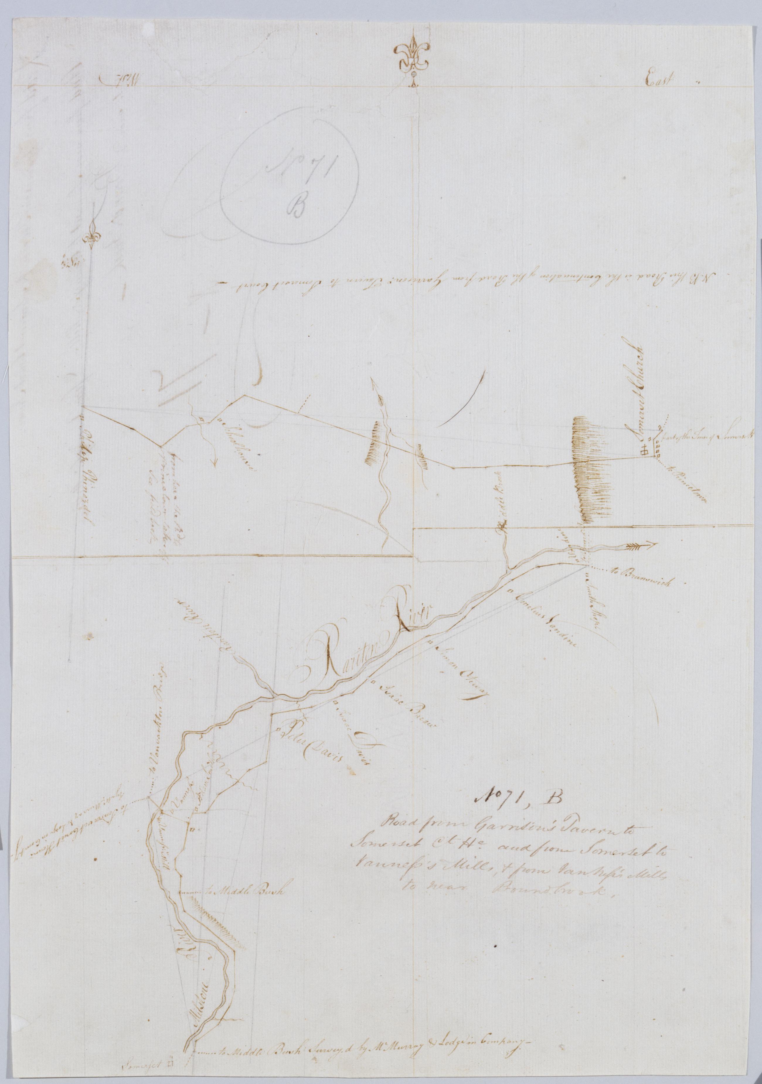
Cartographic Road from Garrison's Tavern to Somerset Ct He. and from Somerset to Vanness's Mills, + from Van Vess's Mills to near Boundbrook. No. 71, B / by Robert Erskine F.R.S. Geogr. A. U.S. and Assistants. Creased, torn and abraded. Mounted on cloth, bound and cropped, disbound and silked by subsequent owners. Cleaned after removal of backings 1999; some fill remains. Sheathed in mylar. In pencil on recto "No 71 B". Military topographic maps. Upper map covers the township of Hillsboro in Somerset County, New Jersey; it shows roads running through Millstone (Someret). Lower map covers the townships of Hillsboro, Bridgewater and Franklin, also in Somerset County; it shows roads running through South Broundbrook and East Millstone. View Item
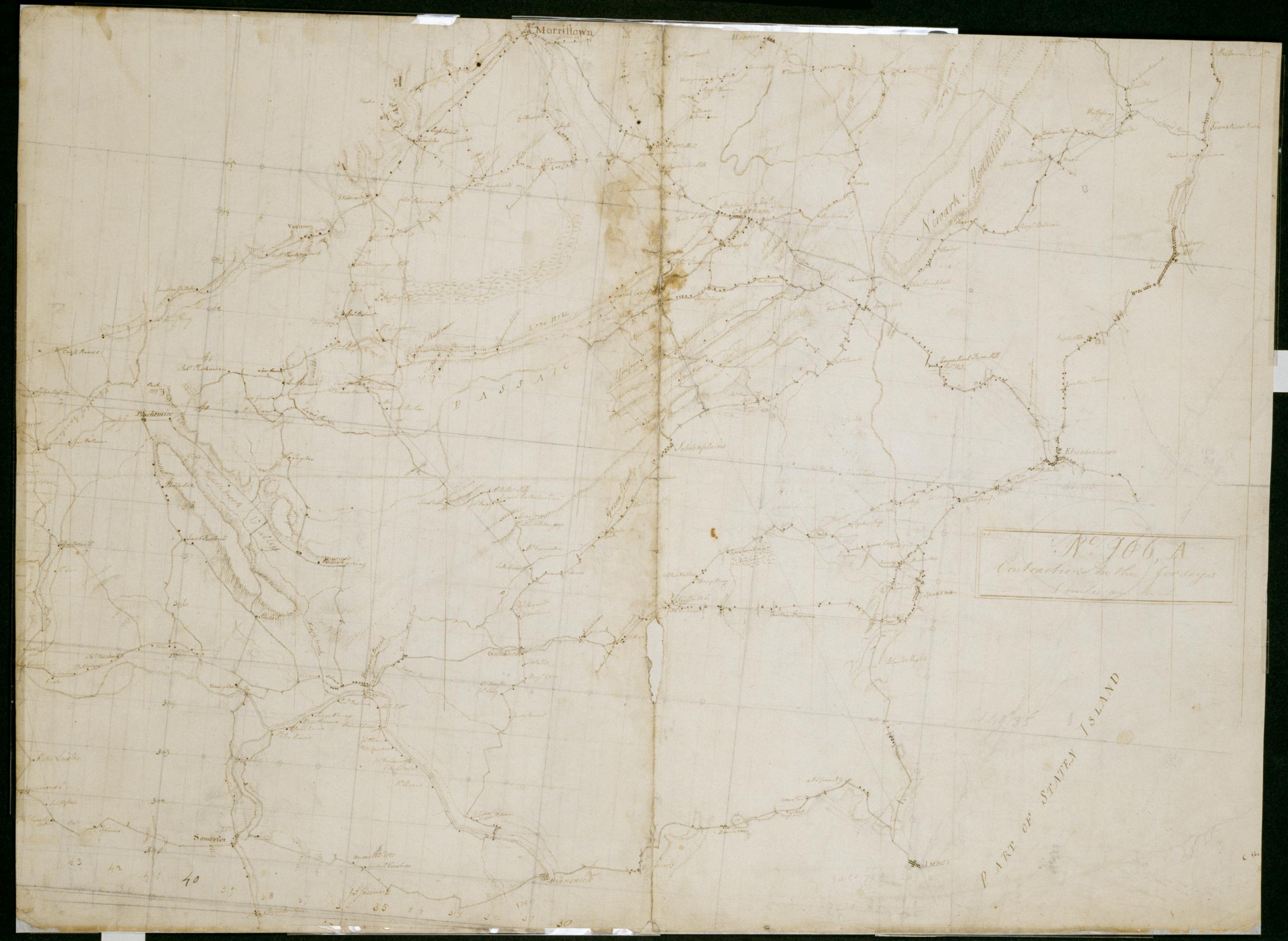
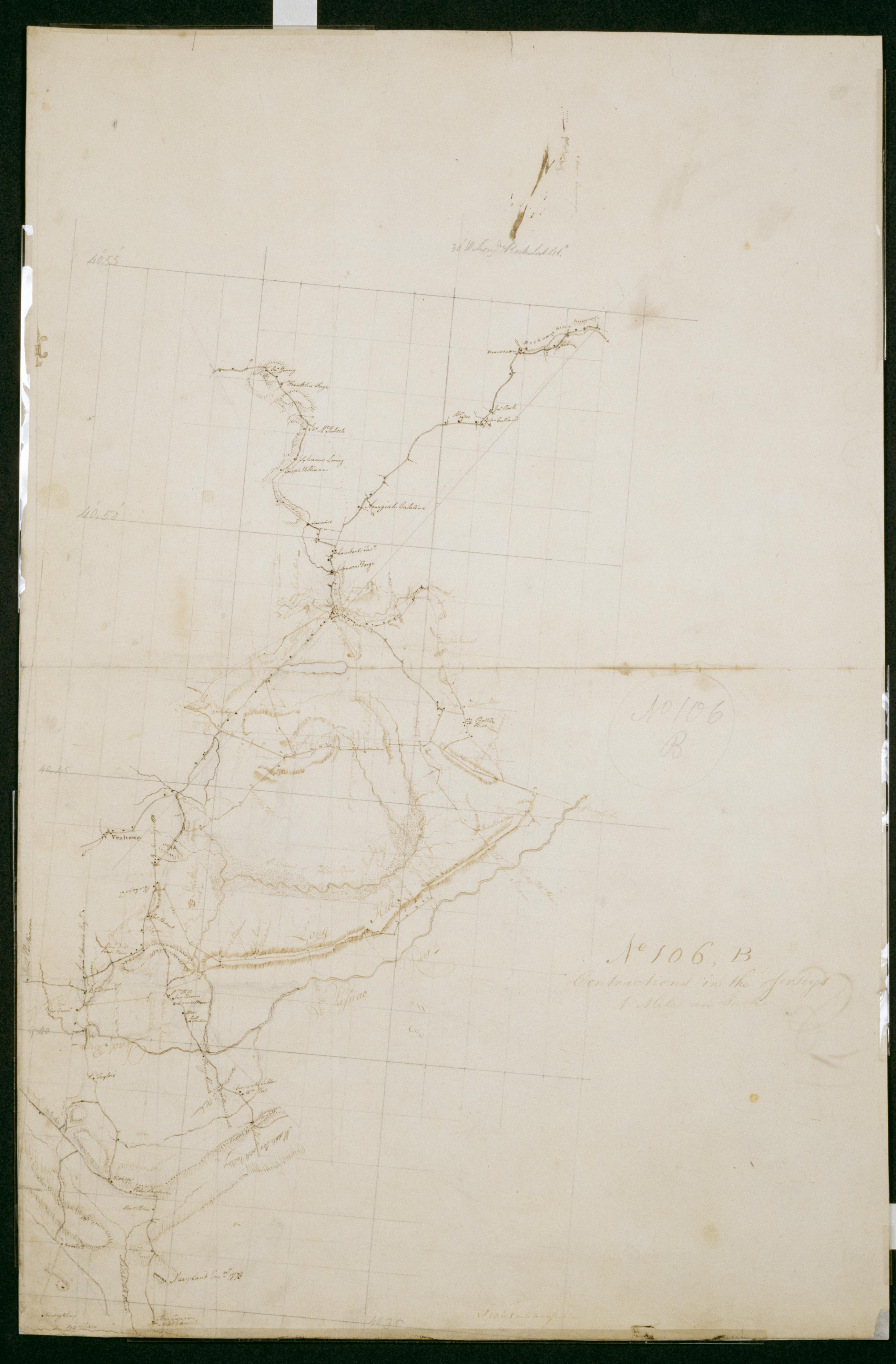
Cartographic Contraction in the Jerseys 1 mile an Inch. No. 106, A / by S. DeWitt A.B. ; by Robert Erskine F.R.S. Geogr. A. U.S. and Assistants. Imperfect: lacking 6 x 1 cm. at lower center of sheet. In ink on verso "No- 106- A". In pencil on recto: "No 106 A". Military topographic map. Covers the counties of Middlesex, Union, Essex, Somerset and Morris in New Jersey. Shows buildings and owners' names, landforms and streams. Pen-and-ink, pencil on laid paper. Shows relief by hachures. Stained, creased, frayed and abraded. Mounted on cloth, bound and cropped, disbound and silked by subsequent owners. Cleaned after removal of backings 1999; re-backed with China paper. Sheathed in mylar. View Item
Cartographic Roads from the Cross-roads through Pluckemin, towards Morristown. No 70, B / by Robert Erskine F.R.S. Geogr. A. U.S. and Assistants. Foxed, creased, torn, frayed and abraded. Mounted on cloth, bound and cropped, disbound and silked by subsequent owners. Cleaned after removal of backings 1999; some fill remains. Lined with China paper. Sheathed in mylar. Imperfect: lacking two small pieces at map center. In pencil on recto: "No 70 B". Military topographic map. Covers the townships of Bernard and Bedminster in Somerset County, New Jersey. Shows roads running through Greater Crossroads, Pluckemin and Liberty Corner. Also shows buildings and owners' names, landforms and streams. Pen-and-ink, pencil on laid paper. View Item
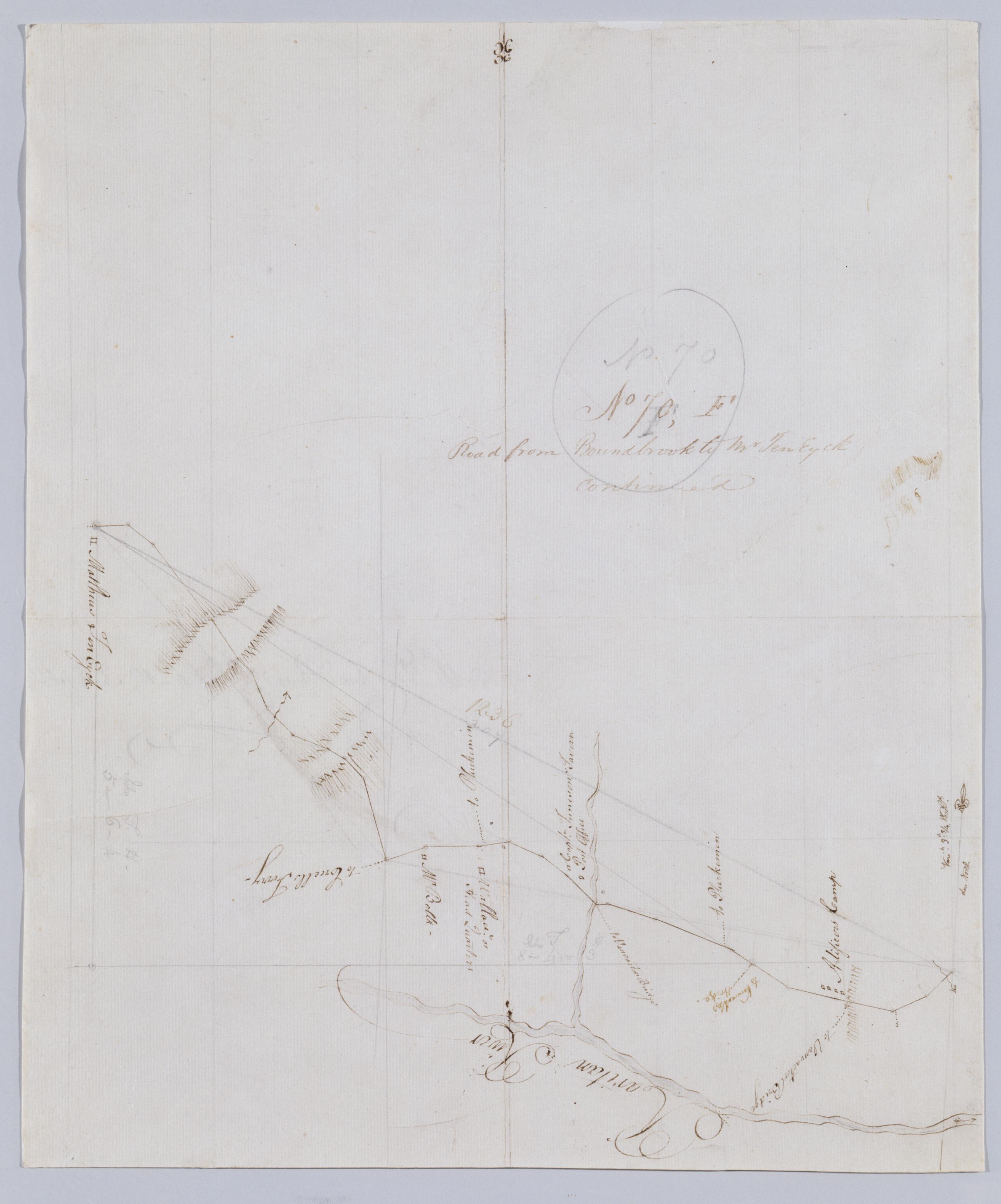
Cartographic Road from Boundbrook to Mr Ten Eyck continued. No 70, F / by Robert Erskine F.R.S. Geogr. A. U.S. and Assistants. In pencil on recto: "No 70 F". Military topographic map. Covers the township of Bridgewater in Somerset County, New Jersey. Shows roads running through Somerville. Also shows buildings and owners' names, landforms and streams. Pen-and-ink, pencil on laid paper. Scale distorted in parts; varies between ca. 1:30,000 and ca. 1:40,000. Shows relief by hachures. Stained, foxed, torn, creased and abraded. Mounted on cloth, bound and cropped, disbound and silked by subsequent owners. Cleaned after removal of backings 1999; some fill remains. Sheathed in mylar. View Item
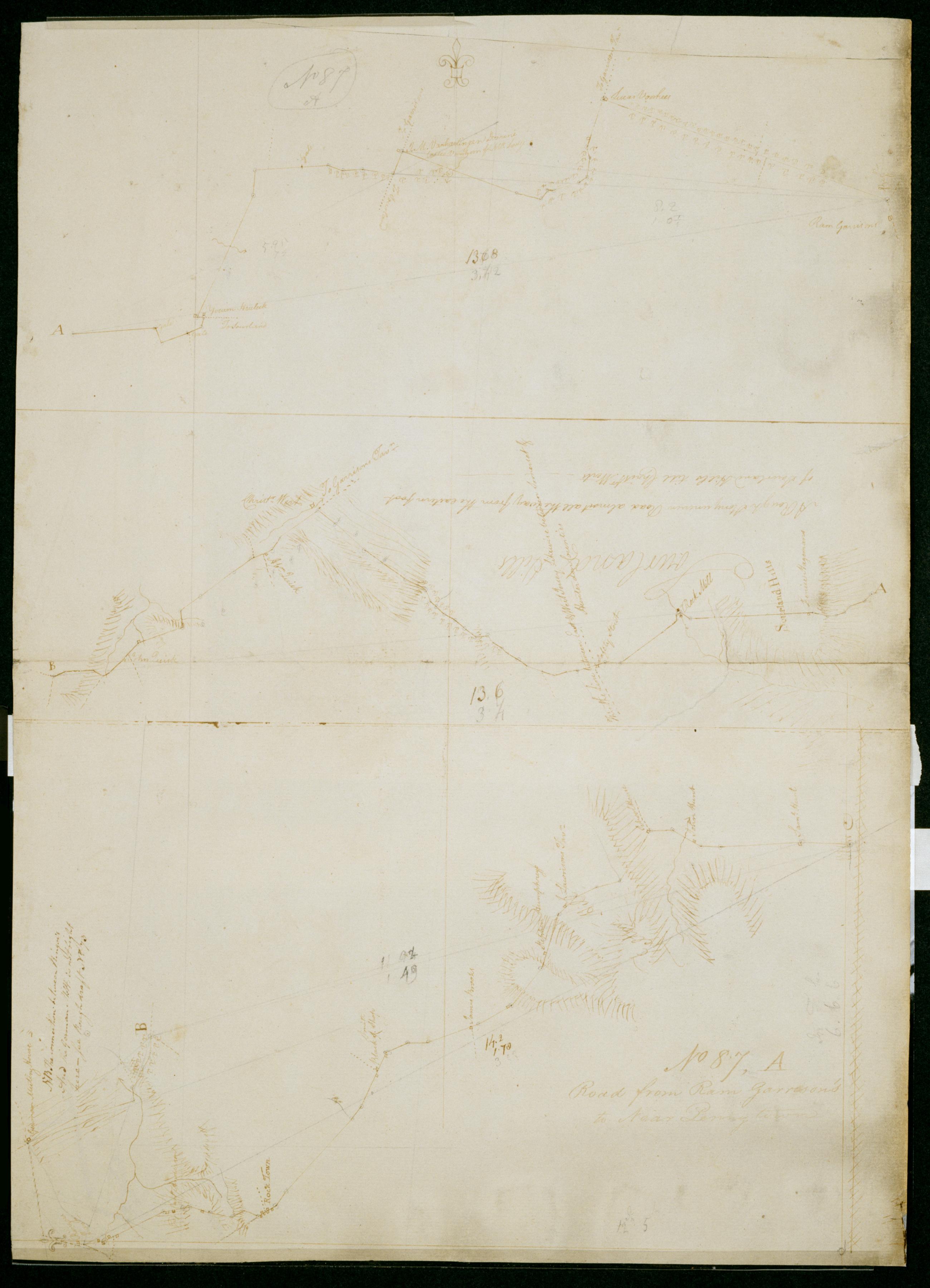
Cartographic Road from Ram Garrison's to Near Penny town. No 87, A / by Robert Erskine F.R.S. Geogr. A. U.S. and Assistants. In pencil on recto: "No 87 A". Military topographic map in three segments meant to be joined at points marked "A" and "B." Top and middle segments oriented with north to top of sheet; bottom segment oriented with north to left of sheet. Map covers the townships of Hillsboro and Montgomery in Somerset County, East Amwell and West Amwell in Hunterdon County and Hopewell in Mercer County, New Jersey. View Item
Cartographic Contractions in the Jerseys 1 Mile an Inch. No 106, B / by S. DeWitt A.B. ; by Robert Erskine F.R.S. Geogr. A. U.S. and Assistants. Imperfect: lacking 1 x 4 cm. at center of sheet. In ink on verso "No 106 B B B". In pencil on recto: "No 106 B". Military topographic map. Covers the counties of Union, Somerset and Morris in New Jersey. Shows buildings and owners' names, landforms and streams. Also shows position of "Maryland Enc[ampmen]t 1778." Pen-and-ink, pencil on laid paper. Shows relief by hachures. Stained, creased, frayed and abraded. Mounted on cloth, bound and cropped, disbound and silked by subsequent owners. Cleaned after removal of backings 1999; re-backed with China paper. Sheathed in mylar. View Item
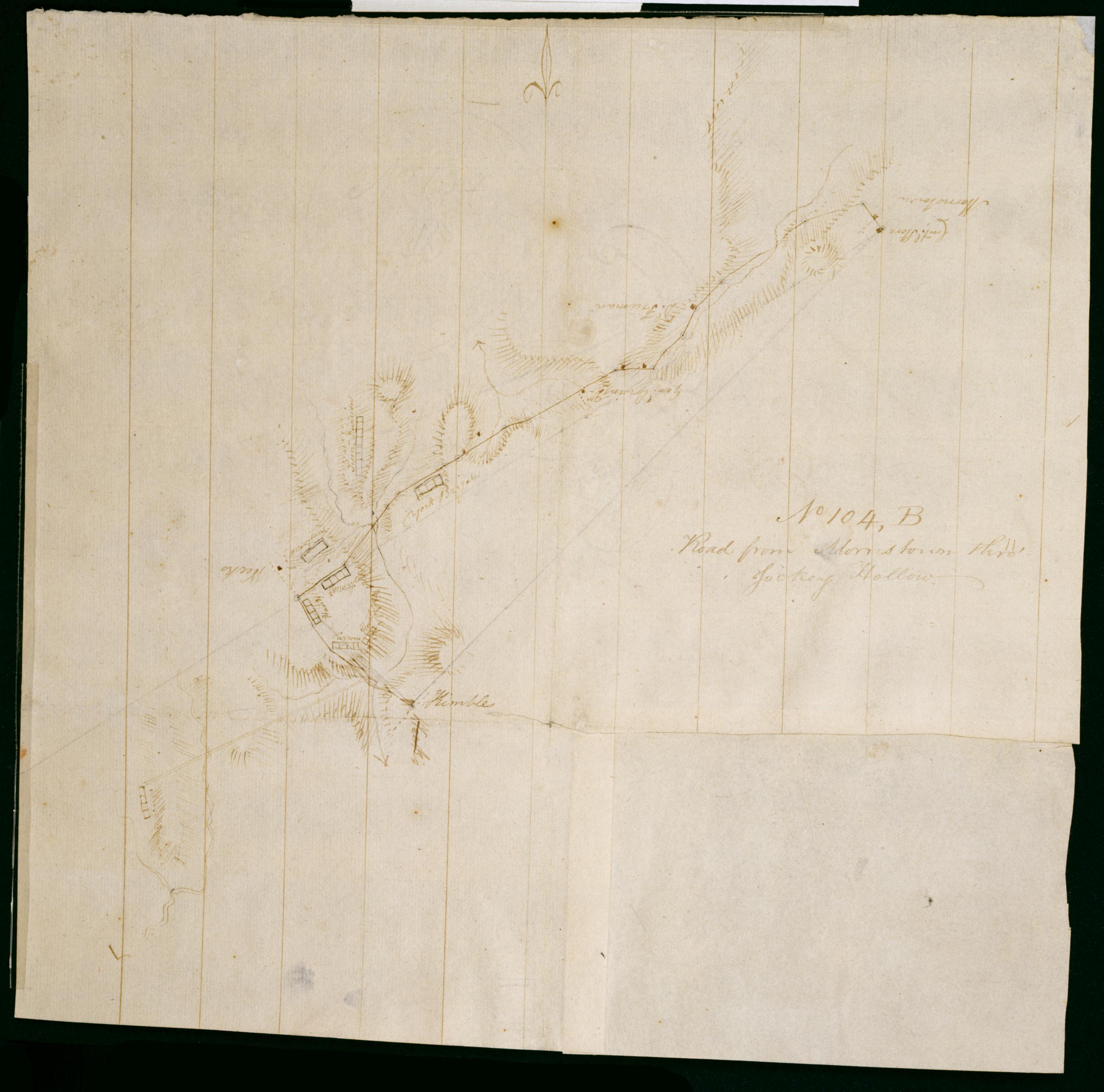
Cartographic Road from Morristown thro' Jockey Hollow. No 104, B / by Robert Erskine F.R.S. Geogr. A. U.S. and Assistants. Foxed, creased, frayed and abraded. Mounted on cloth, bound and cropped, disbound and silked by subsequent owners. Cleaned after removal of backings 1999; some fill remains. Sheathed in mylar. In erased pencil on recto: "No 104 B". Military topographic map. Covers the townships of Passaic and Morris in Morris County and of Bernard in Somerset County, New Jersey. Marks and lables troop positions at Morristown. Also shows roads, buildings and owners' names, landforms and streams. Pen-and-ink, pencil on laid paper. Patch at right corner is later, wove finish paper. Shows relief by hachures. View Item
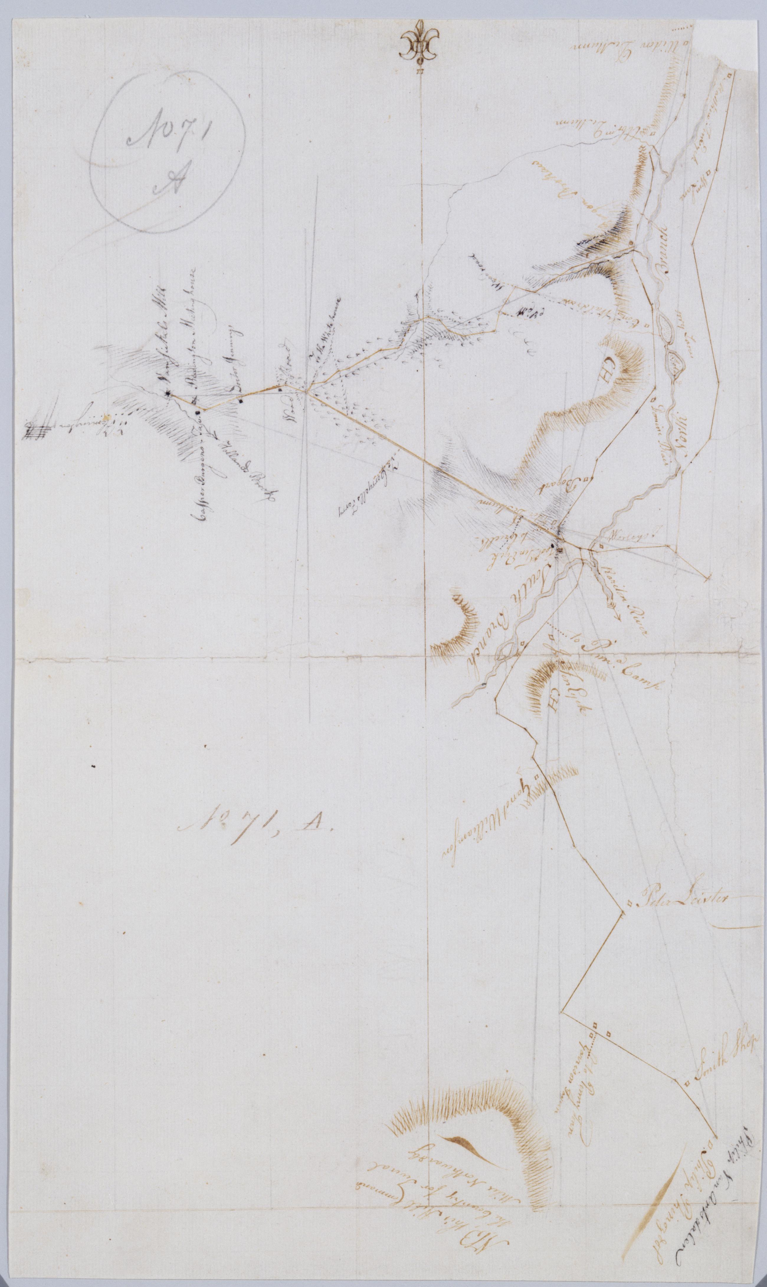
Cartographic [Garisons Somerset Boundbrook from South Branch to Reddington Brokaws] No. 71, A / by Robert Erskine F.R.S. Geogr. A. U.S. and Assistants. Foxed, creased, frayed and abraded. Mounted on cloth, bound and cropped, disbound and silked by subsequent owners. Cleaned after removal of backings 1999; some fill remains. Sheathed in mylar. In ink on verso: "A - 71". In pencil on recto "No 71 A". Military topographic map. Covers the townships of Readington and Branchburg in Hunterdon County and of Bridgewater and Hillsboro in Somerset County, New Jersey. Shows roads running through Readington, North Branch, Milltown, South Branch, Flagtown and Frankfort. Also shows buildings and owners' names, landforms and streams. View Item
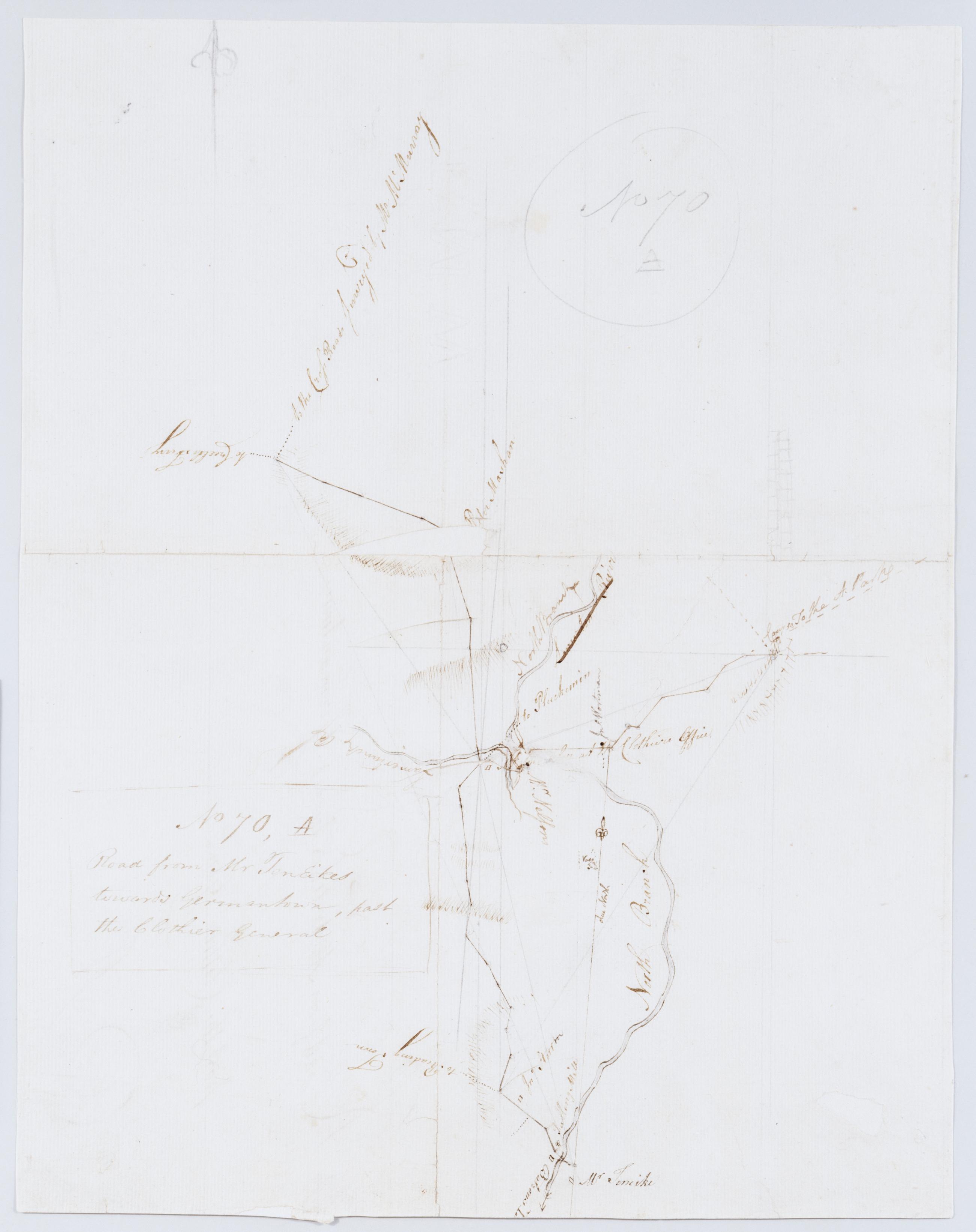
Cartographic Road from Mr TenEikes towards Germantown, past the Clothier General. No 70, A / by Robert Erskine F.R.S. Geogr. A. U.S. and Assistants. Foxed, creased, torn, frayed and abraded. Mounted on cloth, bound and cropped, disbound and silked by subsequent owners. Cleaned after removal of backings 1999; some fill remains. Lined with China paper. Sheathed in mylar. Imperfect: lacking 5 x 1 cm. at map center, 1 x 1 at lower right. In pencil on recto: "No 70 A". Military topographic map. Covers the townships of Bedminster and Bridgewater in Somerset County and of Branchburg in Hunterdon County, New Jersey. Shows roads running through Lamington, Burnt Mill, North Branch and Pluckemin. View Item
Cartographic From where a road branches to Middle Bush to Princeton + a little way farther towds Trenton. No 121, A / by Robert Erskine F.R.S. Geogr. A. U.S. and Assistants. Military topographic map. Covers the townships of Princeton in Mercer County, Franklin in Somerset County and South Brunswick in Middlesex County, New Jersey. Shows roads running through Princeton, Kingston, Tenmile Run and Franklin Park. Also shows buildings and owners' names, landforms and streams. Pen-and-ink, pencil on laid paper. Shows relief by hachures. Stained, soiled, creased and abraded. Mounted on cloth, bound and cropped, disbound and silked by subsequent owners. Cleaned after removal of backings 1999; some fill remains. Sheathed in mylar. View Item
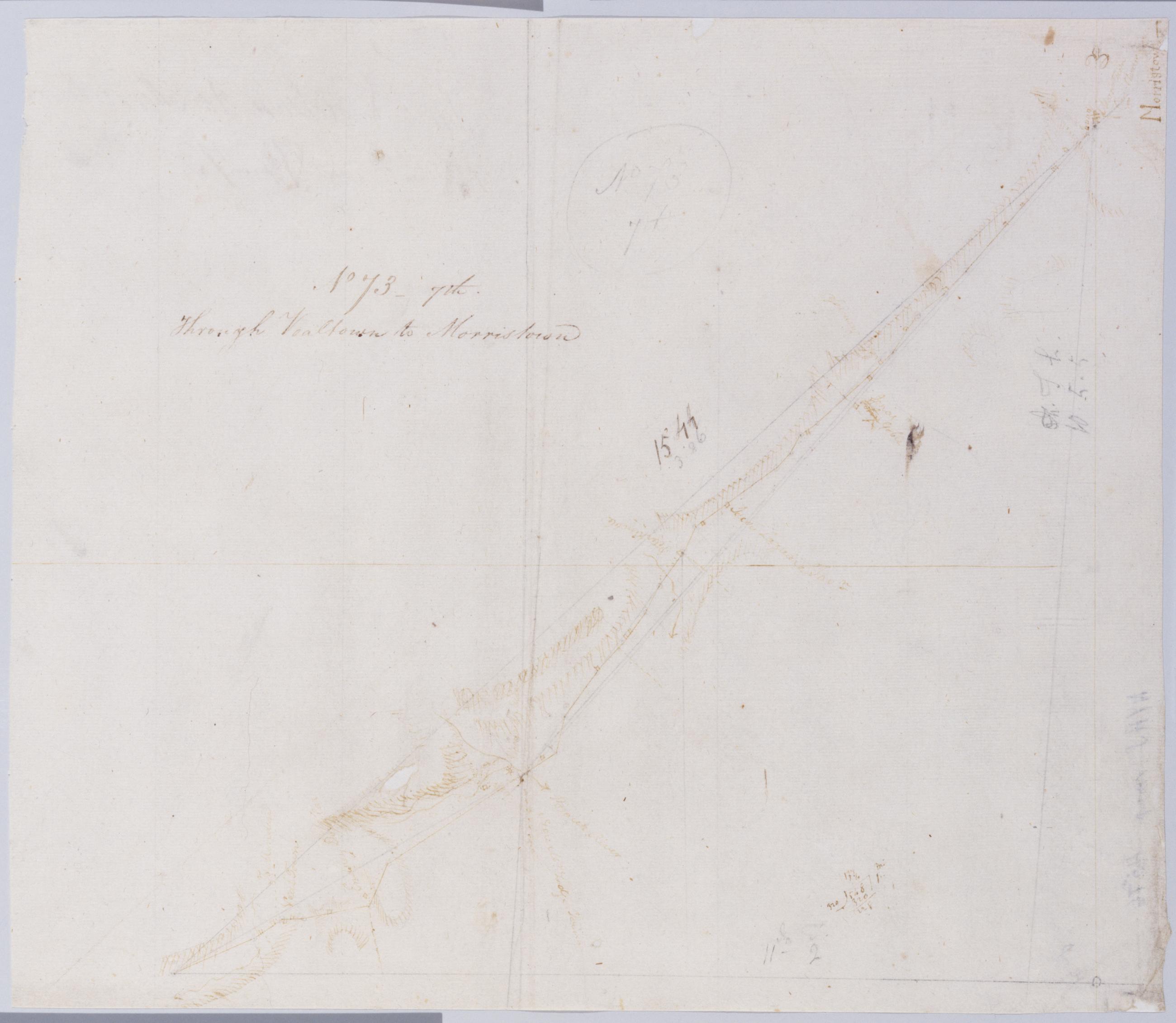
Cartographic Through Vealtown to Morristown. No 73, 7th / by Robert Erskine F.R.S. Geogr. A. U.S. and Assistants. Foxed, creased, frayed and abraded. Mounted on cloth, bound and cropped, disbound and silked by subsequent owners. Cleaned after removal of backings 1999; some fill remains. Sheathed in mylar. In pencil on recto: "No 73 7th". Military topographic map. Covers the township of Bernard in Somerset County and that of Morris in Morris County, New Jersey. Shows roads running through Bernardsville and Morristown. Also shows buildings and owners' names, landforms and streams. Pen-and-ink, pencil on laid paper. Shows relief by hachures. View Item
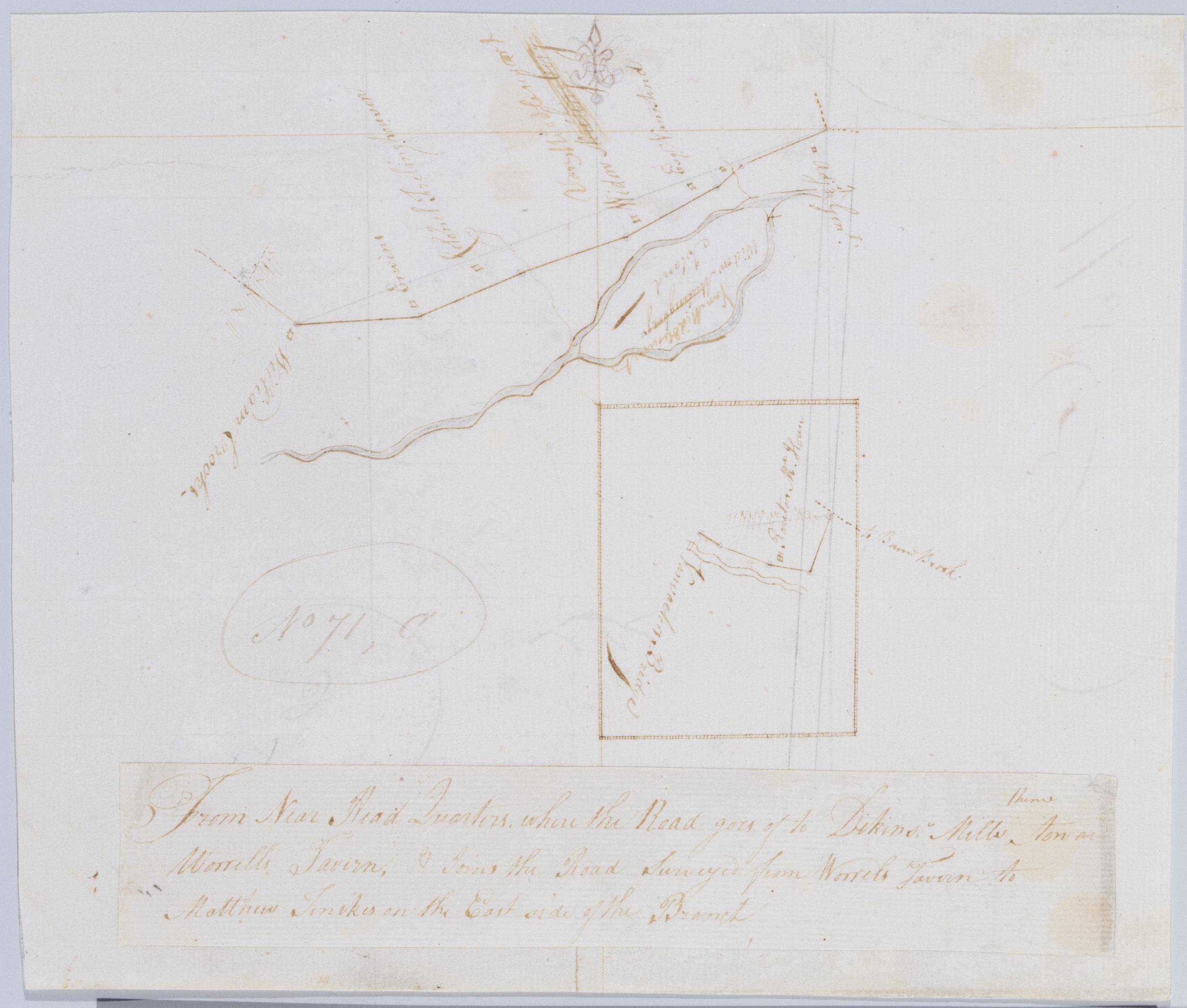
Cartographic From Near Head Quarters where the Road goes of thence to Dikins' Mills toward Worrells Tavern, & Joins the Road Surveyed from Worrels Tavern to Matthew Tenikes on the East side of the Branch. No 71, C / by Robert Erskine F.R.S. Geogr. A. U.S. and Assistan In ink on verso: "C - N 71". Inset map apparently covers a small area two minutes east of that covered by the main map; Vanvactors Bridge seems to have been located on the Raritan River at W 74⁰35ʹ. Military topographic map. Covers the townships of Hillsboro and Bridgewater in Somerset County, New Jersey. Show roads running through Raritan village; also buildings and owners' names, landforms and streams. Pen-and-ink, pencil on laid paper. Title on a separate piece pasted atop sheet. Shows relief by hachures. Stained and abraded. View Item
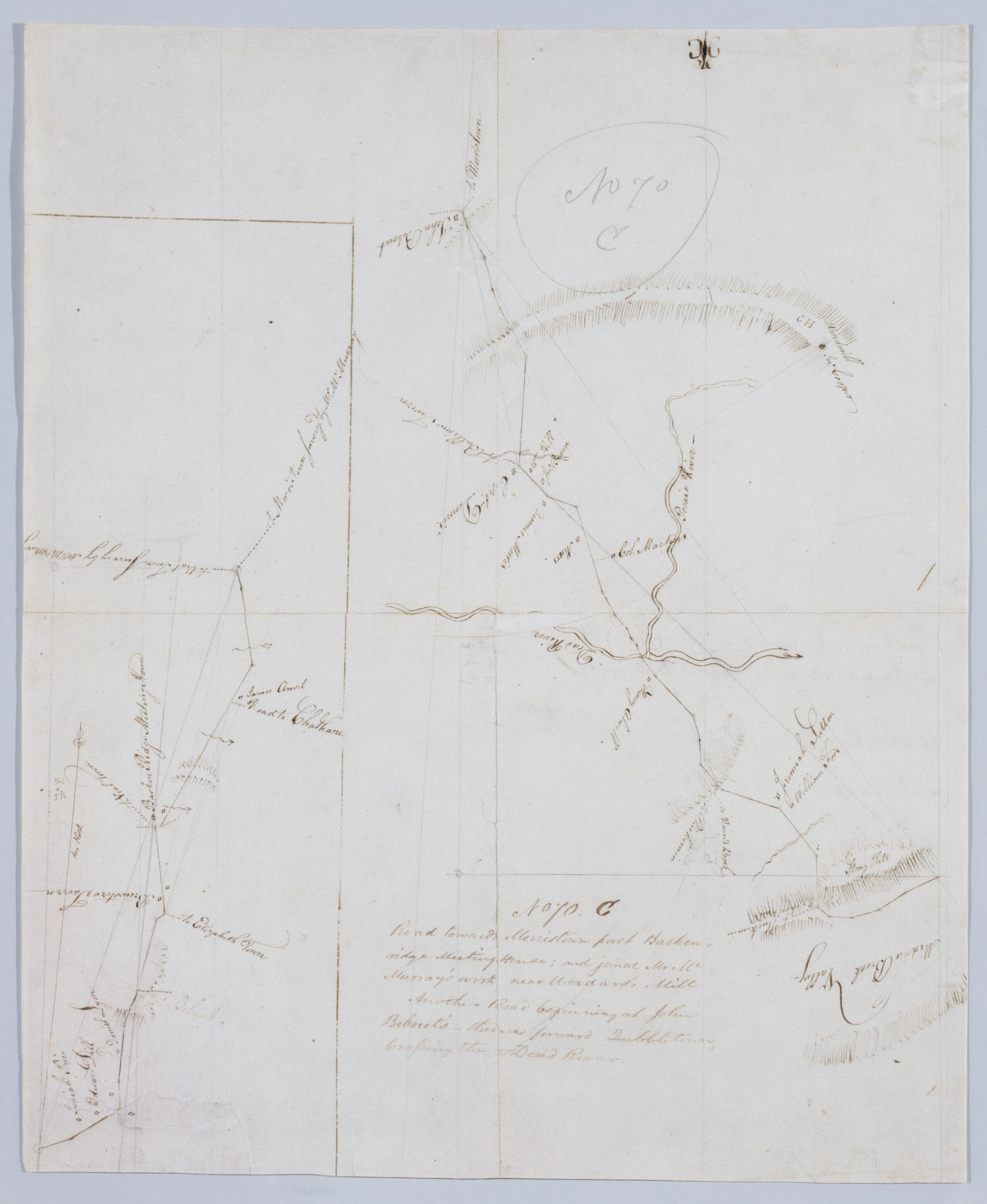
Cartographic Road towards Morristown past Baskenridge Meeting House; and joined Mr. McMurray's work near Woodard's Mill ; Another Road beginning at John Bebout's, thence toward Quibbletown, Crossing the Dead River. No 70. C by Robert Erskine F.R.S. Geogr. A. U.S. and Foxed, creased, torn, frayed and abraded. Mounted on cloth, bound and cropped, disbound and silked by subsequent owners. Cleaned after removal of backings 1999; some fill remains. Sheathed in mylar. Imperfect: lacking 1 x 2 cm. at map center. In pencil on recto: "No 70 C". Military topographic maps. The lefthand, smaller map covers the township of Bernard in Somerset County, New Jersey; it shows roads running through Madisonville and Basking Ridge. The larger map covers the townships of Bernard, Warren and North Plainfield in the same county; it shows roads running through Lyons and Mt. View Item
Cartographic Road from Kembles to Chatham. No 104 A / by Robert Erskine F.R.S. Geogr. A. U.S. and Assistants. Foxed- creased- frayed and abraded. Mounted on cloth- bound and cropped- disbound and silked by subsequent owners. Cleaned after removal of backings 1999; some fill remains. Sheathed in mylar. In pencil on recto: "No 104 A". Military topographic map. Covers the townships of Passaic and Morris in Morris County and of Bernard in Somerset County- New Jersey. Shows roads running through Chatham- Morristown- Logansville- Millington and Liberty Corner. Also shows buildings and owners' names- landforms and streams. Pen-and-ink- pencil on laid paper. Shows relief by hachures. View Item
Cartographic From the Cross-roads crossing the North Branch of Rariton to near Vealtown towards Morristown. No 73 6th / by Robert Erskine F.R.S. Geogr. A. U.S. and Assistants. Also in ink on verso: "Road from near Veal". Foxed- creased- torn- frayed and abraded. Mounted on cloth- bound and cropped- disbound and silked by subsequent owners. Cleaned after removal of backings 1999; some fill remains. Sheathed in mylar. In pencil on recto: "No 73 6th". Military topographic map. Covers the townships of Bedminster and Bernard in Somerset County- New Jersey. Shows roads running through Greater Crossroads- Bedminster and Far Hills. Also shows buildings and owners' names- landforms and streams. Pen-and-ink- pencil on laid paper. Shows relief by hachures. View Item
Cartographic Road from Mount Bethel Meeting House to near Quibbletown and from Quibbletown to Brunswick. No 70 D / by Robert Erskine F.R.S. Geogr. A. U.S. and Assistants. Foxed- creased and abraded. Mounted on cloth- bound and cropped- disbound and silked by subsequent owners. Cleaned after removal of backings 1999; some fill remains. Sheathed in mylar. Imperfect: lacking small piece at lower left corner. In pencil on recto: "No 70 D". Military topographic map. Covers the townships of Warren and North Plainfield in Somerset County and of Piscataway in Middlesex County- New Jersey. Shows roads running through Mt. Bethel- Newmarket- Newtown and New Brunswick. Also shows buildings and owners' names- landforms and streams. Pen-and-ink- pencil on laid paper. View Item
Cartographic Road from Brunswick thro' Somerset to Van Vacter's Bridge. No 74 F / by Robert Erskine F.R.S. Geogr. A. U.S. and Assistants. In pencil on recto: "No 74 F". Military topographic map. Covers the townships of Franklin and Hillsboro in Somerset County- New Jersey. Shows roads running through New Brunswick- Middlebush- East Millstone- Weston and Finderne. Also shows buildings and owners' names- landforms and streams. Pen-and-ink- pencil on laid paper. Shows relief by hachures. Soiled- creased- and abraded. Mounted on cloth- bound and cropped- disbound and silked by subsequent owners. Cleaned after removal of backings 1999; some fill remains. Sheathed in mylar. View Item
Cartographic Through Scotch Plains & Springfield. No 67 C / by Robert Erskine F.R.S. Geogr. A. U.S. and Assistants. In ink on recto: "C". In pencil on recto:"No 67 C". Military topographic map. Covers the townships of South Orange- Milburn and Union in Essex County and of Springfield- Westfield and Fanwood in Somerset County- New Jersey. Shows roads running though Springfield- Branch Mills- Locust Grove- Scotch Plains and Netherwood. Also shows buildings and owners' names- also landforms and streams. Pen-and-ink- pencil on laid paper. Shows relief by hachures. Stained- creased- frayed and abraded. Mounted on cloth- bound and cropped- disbound and silked by subsequent owners. View Item
Cartographic Road from Brunswick to Boundbrook. No 70 E / by Robert Erskine F.R.S. Geogr. A. U.S. and Assistants. In pencil on recto: "No 70 E". Military topographic map. Covers the townships of Bridgewater and Franklin in Somerset County and of Piscataway in Middlesex County- New Jersey. Shows roads running through Boundbrook- South Boundbrook and New Brunswick. Also shows buildings and owners' names- landforms and streams. Pen-and-ink- pencil on laid paper. Scale distorted in parts; varies between ca. 1:30-000 and ca. 1:40-000. Shows relief by hachures. Stained- foxed- creased and abraded. Mounted on cloth- bound and cropped- disbound and silked by subsequent owners. View Item
Cartographic From Quibbletown towards Scotch Plains. No 67 D / by Robert Erskine F.R.S. Geogr. A. U.S. and Assistants. In Erskine's handwriting- inked on verso after title: "No. 67 C [crossed-out] D CC CC No. 67 D". In ink on recto: "D". In pencil on recto:"No 67 D" (twice). Military topographic map. Covers the townships of Fanwood and Plainfield in Somerset County and of Piscataway in Middlesex County- New Jersey. Shows roads running through Sampton (formerly called Quibbletown) and Netherwood. Also shows buildings and owners' names- landforms and streams. Pen-and-ink- pencil on laid paper. Shows relief by hachures. Stained- creased- torn- frayed and abraded. View Item