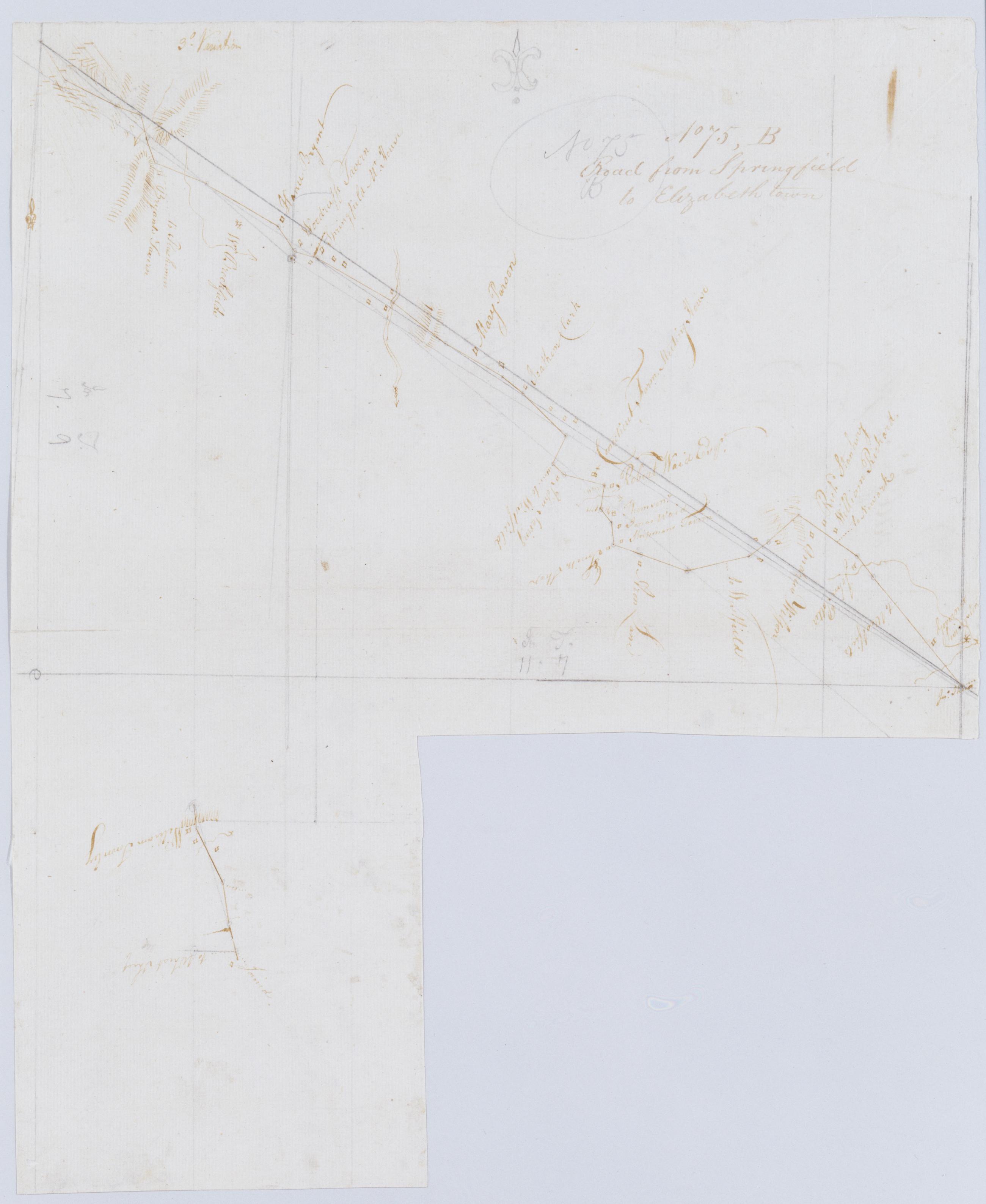
Cartographic Road from Springfield to Elizabeth town. No 75, B / by Robert Erskine F.R.S. Geogr. A. U.S. and Assistants. Imperfect: 15 x 19 cm. at lower right corner cut out after drawing complete; compare cuts to those on 75,A. In pencil on recto: "No 75 B". Military topographic map; lower segment fits to the southeast of the upper one. Map covers the townships of Summit, Springfield and Union in Union County, New Jersey. Shows roads running through Springfield and Elizabeth. Also shows buildings and owners' names, landforms and streams. Pen-and-ink, pencil on laid paper. Shows relief by hachures. Stained, creased and abraded. Mounted on cloth, bound and cropped, disbound and silked by subsequent owners. View Item
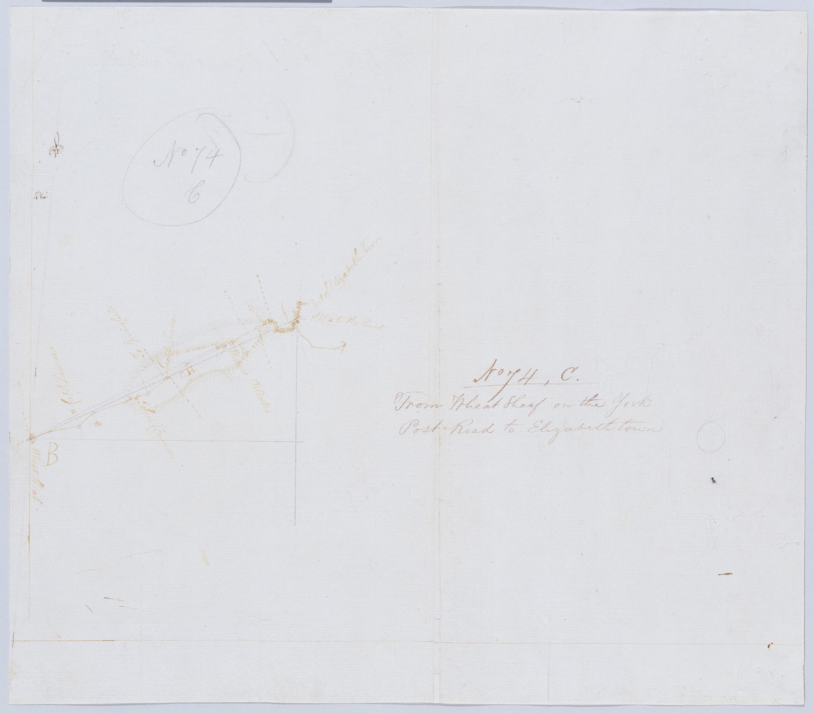
Cartographic From Wheat Sheaf on the York Post Road to Elizabethtown. No 74, C / by Robert Erskine F.R.S. Geogr. A. U.S. and Assistants. In pencil on recto: "No 74 C". Military topographic map. Covers the townships of Union and Linden in Union County, New Jersey. Shows roads running through Wheatsheaf, Linden and Elizabeth. Also shows buildings and owners' names, landforms and streams. Pen-and-ink, pencil on laid paper. Shows relief by hachures. Stained, creased, torn, frayed and abraded. Mounted on cloth, bound and cropped, disbound and silked by subsequent owners. Cleaned after removal of backings 1999; some fill remains. Sheathed in mylar. View Item
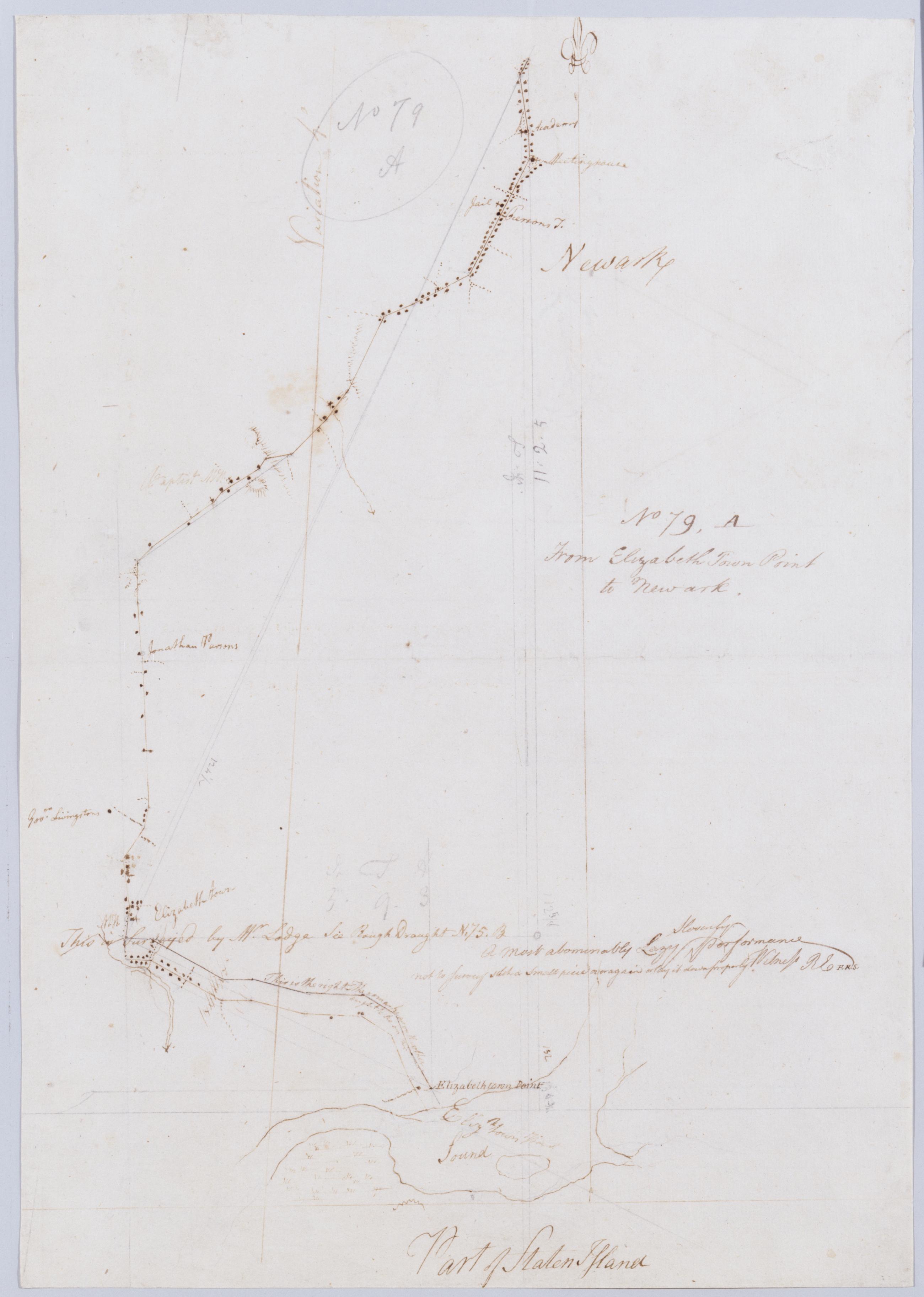
Cartographic From Elizabeth Town Point to Newark. No 79, A / by Robert Erskine F.R.S. Geogr. A. U.S. and Assistants ; this is surveyed by Mr. Lodge .... In ink on verso: "A" Numeral and title cropped off. In pencil on recto: "No 79 A". Includes annotation: "This is surveyed by Mr. Lodge See Rough Draught N.75.B A Most abominably Lazy Slovenly performance not to Survey such a Small piece over again or lay it down properly Witness RE F.R.S." Military topographic map. Covers part of Union and Essex counties in New Jersey. Shows roads running through Elizabeth and Newark. Also shows buildings and owners' names, landforms and streams. Pen-and-ink, pencil on laid paper. Shows relief by hachures. Stained, torn and abraded. View Item
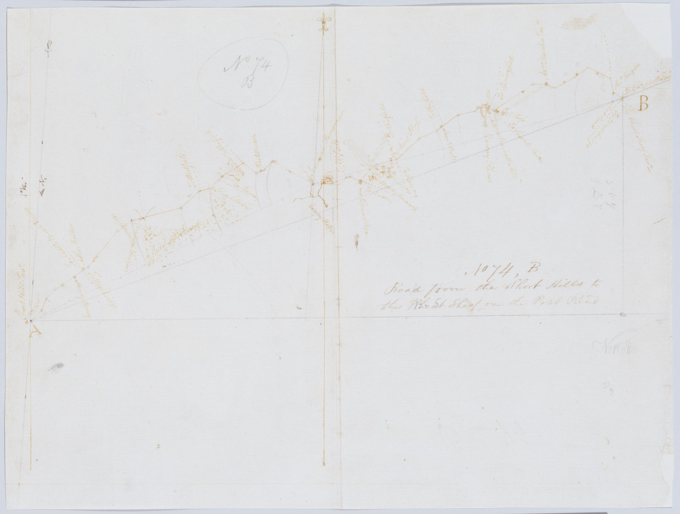
Cartographic Road from the Short Hills to the Wheat Sheaf, on the Post Road. No 74, B / by Robert Erskine F.R.S. Geogr. A. U.S. and Assistants. In pencil on recto: "No 74 B". Military topographic map. Covers the townships of Linden, Clark, Fanwood, Plainfield and Westfield in Union County and of Raritan in Middlesex County, New Jersey. Shows roads running through Willow Grove, Picton and Wheatsheaf. Also shows buildings and owners' names, landforms and streams. Pen-and-ink, pencil on laid paper. Shows relief by hachures. Stained, soiled, creased, torn, frayed and abraded. Mounted on cloth, bound and cropped, disbound and silked by subsequent owners. Cleaned after removal of backings 1999; some fill remains. Sheathed in mylar. View Item
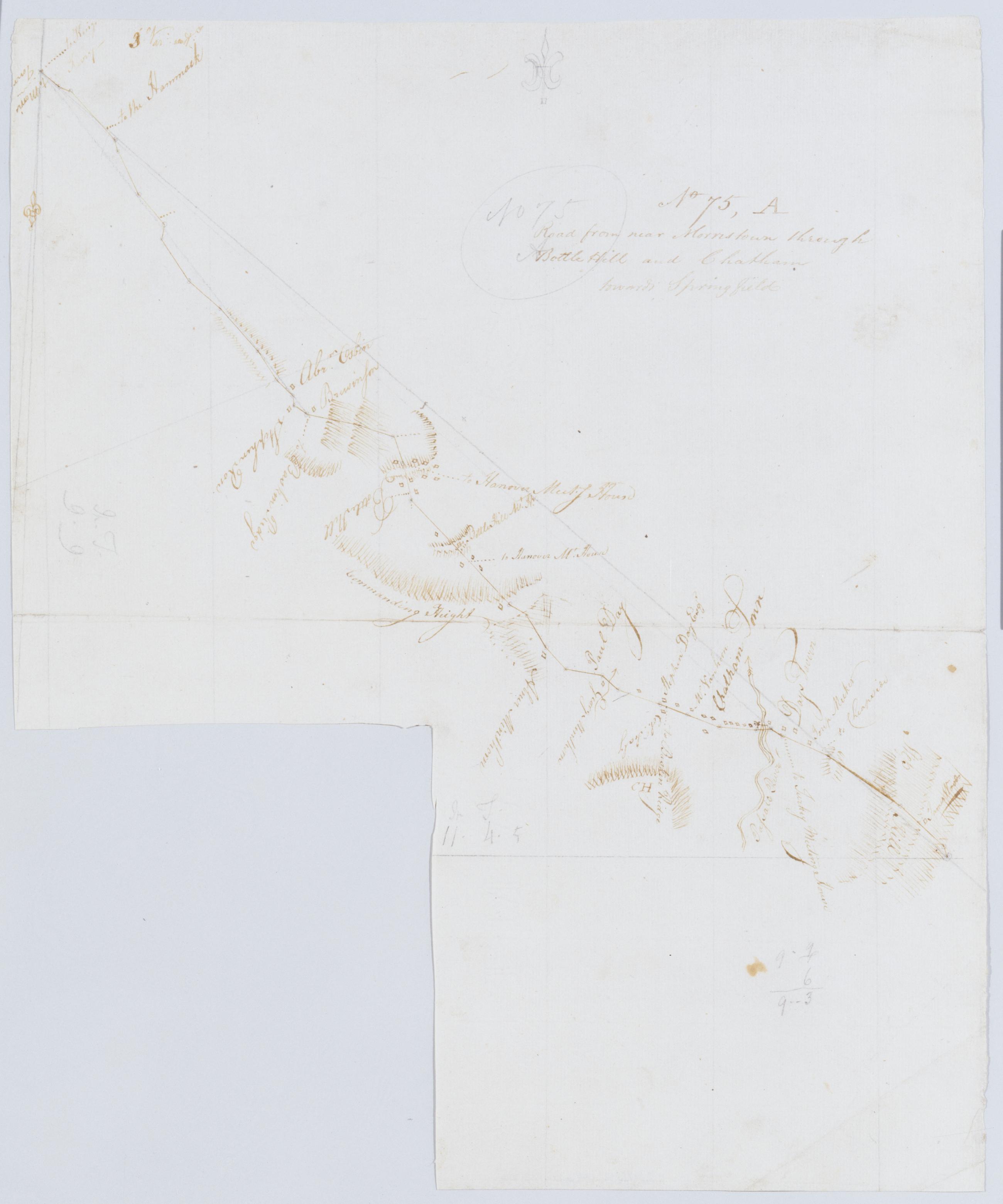
Cartographic Road from near Morristown through Bottle Hill and Chatham towards Springfield. No 75, A / by Robert Erskine F.R.S. Geogr. A. U.S. and Assistants. Fragment of original title in ink on verso: "Roa....". Imperfect: 16 x 14 cm. at lower left corner cut out after title written on verso. In pencil on recto: "No 75 A". Military topographic map. Covers the townships of Morris and Chatham in Morris County, Milburn in Essex County and Union in Summit County, New Jersey. Shows roads running through Morristown and Chatham. Also shows buildings and owners' names, landforms and streams. Pen-and-ink, pencil on laid paper. Shows relief by hachures. Stained, foxed, creased and abraded. View Item
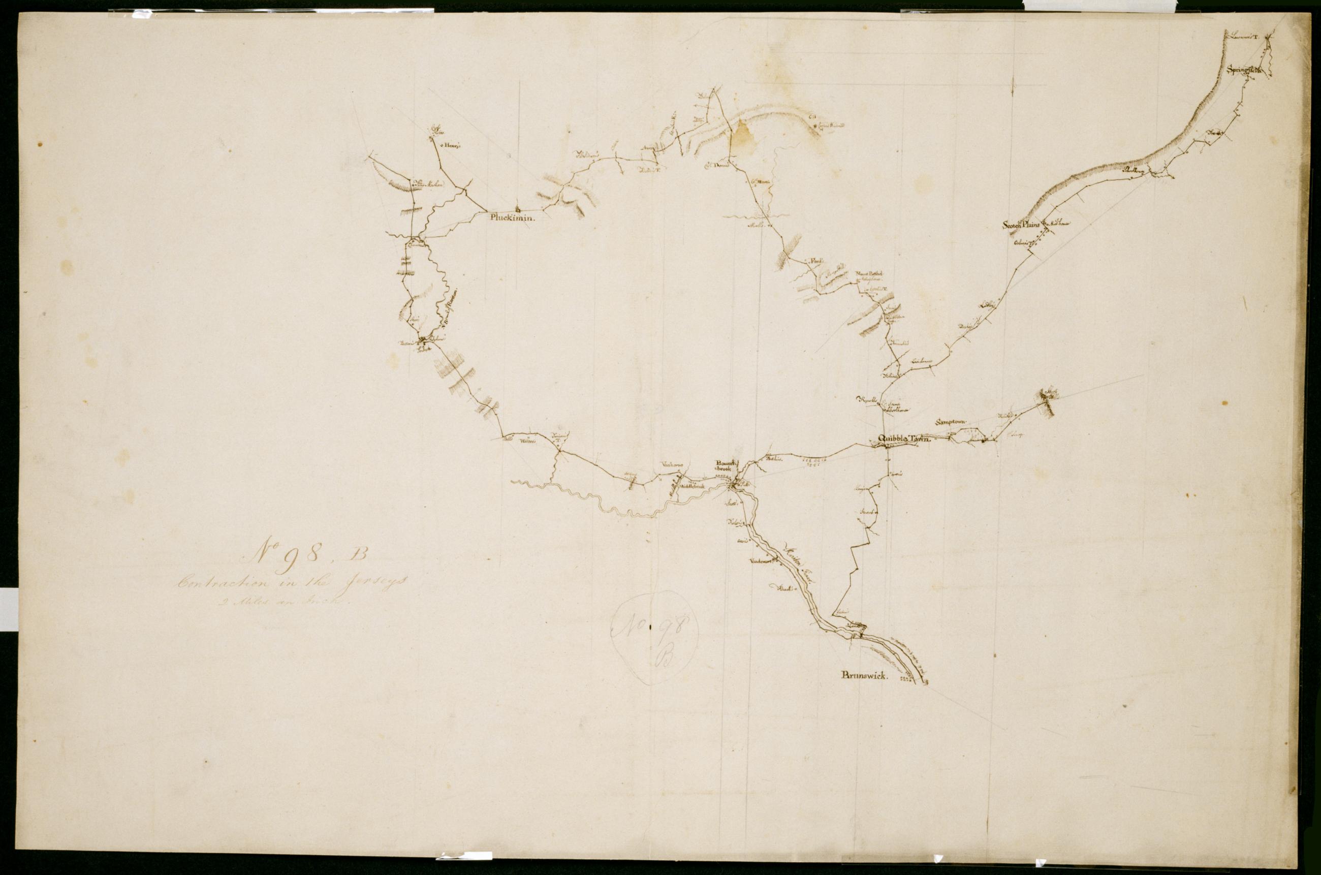
Cartographic Contraction in the Jerseys. No 98, B / Large Paper by Capt. Scull ; by Robert Erskine F.R.S. Geogr. A. U.S. and Assistants. Foxed, stained, soiled, creased, frayed and abraded. Mounted on cloth, bound and cropped, disbound and silked by subsequent owners. Cleaned after removal of backings 1999; some fill remains. Sheathed in mylar. In ink on verso "No. 98 B." In pencil on recto: "No. 98 B". Military topographic map. Covers parts of Middlesex, Somerset and Union counties in New Jersey. Also shows buildings and owners' names, landforms and streams. Pen-and-ink, pencil on laid paper. Scale as drawn 1 in. per mi. Shows relief by hachures. View Item
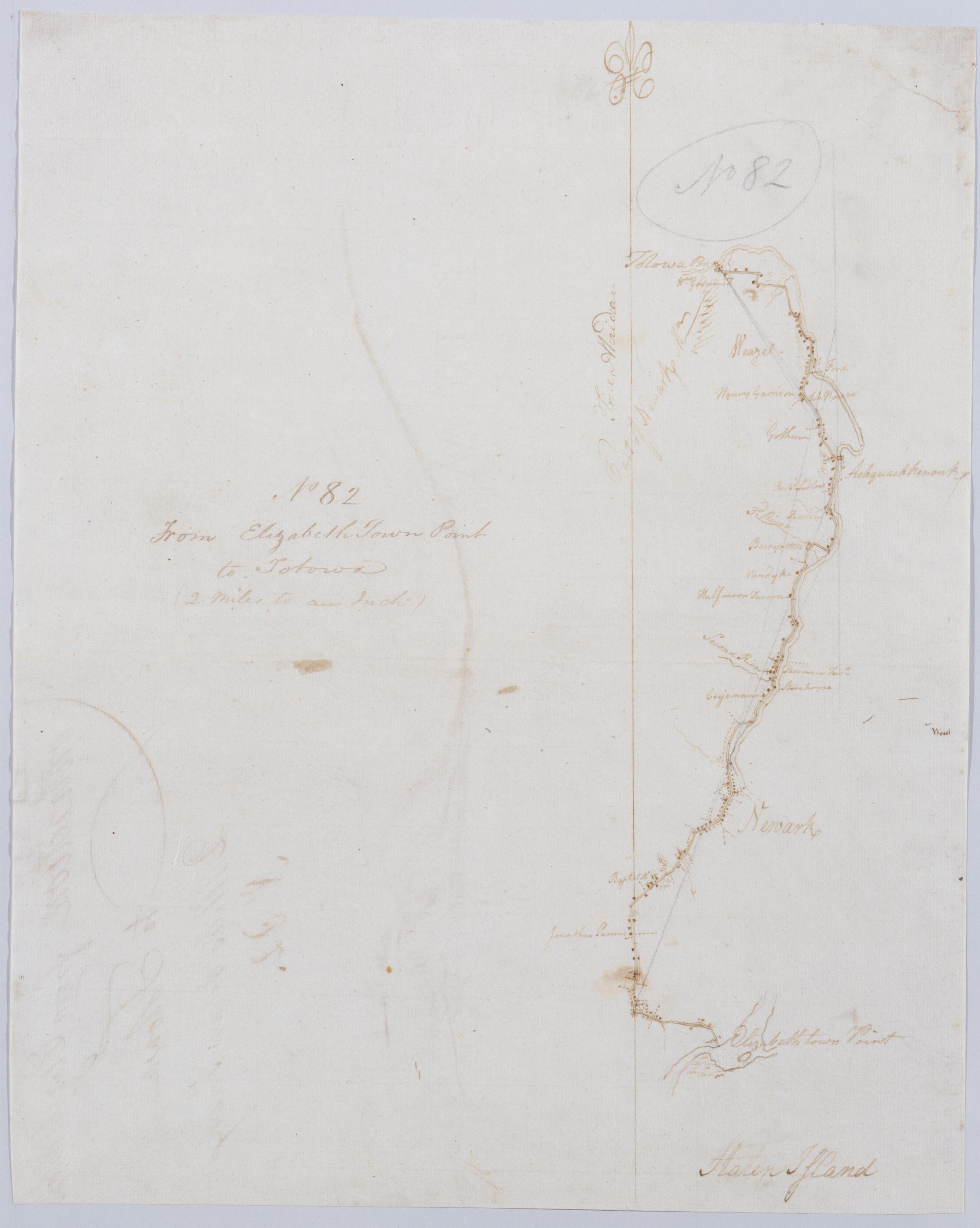
Cartographic From Elizabeth Town Point to Totowa : (2 Miles to an Inch) No 82 / by Robert Erskine F.R.S. Geogr. A. U.S. and Assistants. In pencil on recto: "No 82". Military topographic map. Covers parts of Passaic, Essex and Union counties in New Jersey. Shows roads running through Elizabeth, Newark, Belleville, Clifton, South Paterson and Totowa. Also shows buildings and owners' names, landforms and streams. Pen-and-ink, pencil on laid paper. Shows relief by hachures. Stained, soiled, frayed and abraded. Mounted on cloth, bound and cropped, disbound and silked by subsequent owners. Cleaned after removal of backings 1999; some fill remains. Sheathed in mylar. View Item
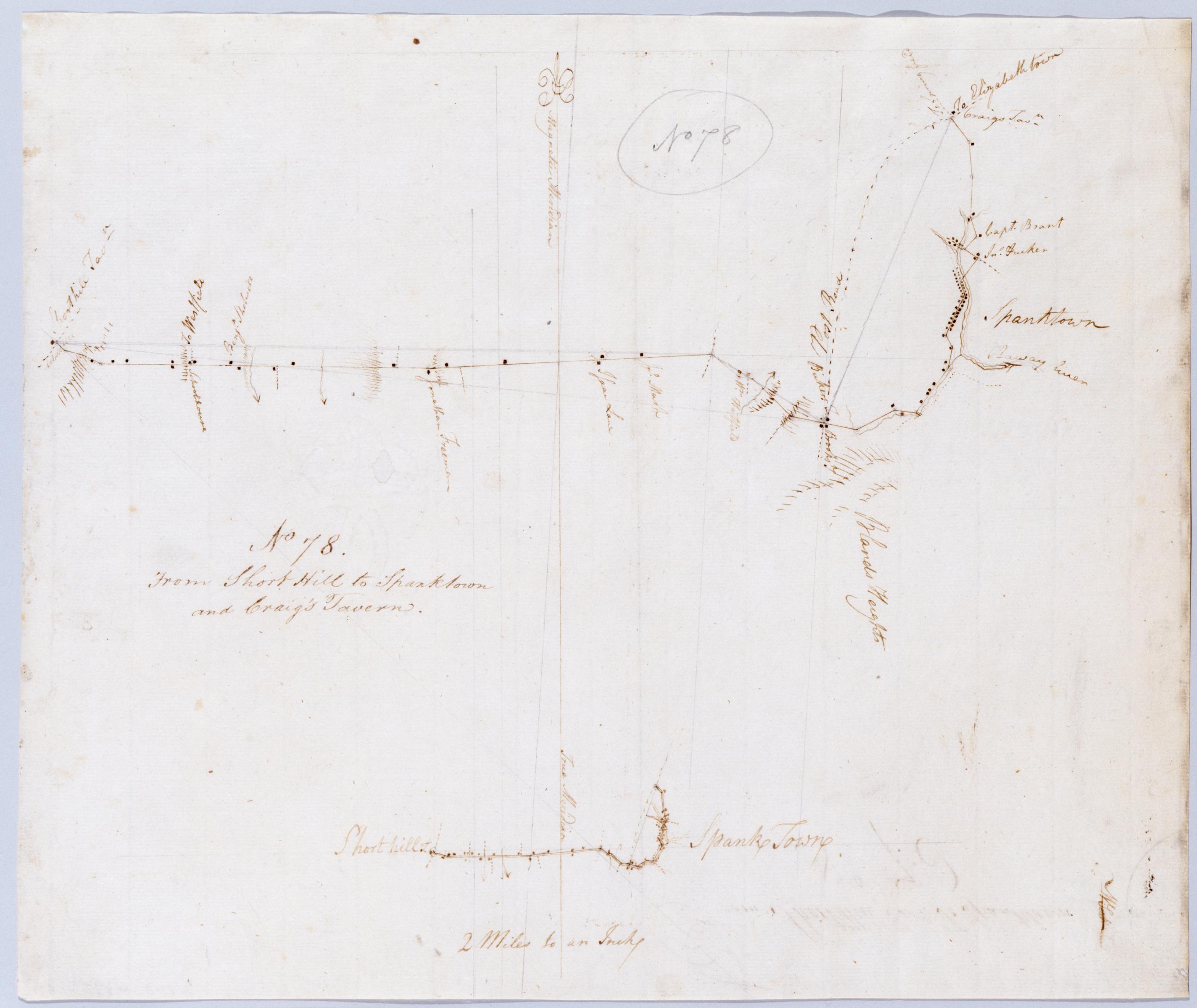
Cartographic From Short Hill to Spanktown and Craig's Tavern. No 78 / by Robert Erskine F.R.S. Geogr. A. U.S. and Assistants. In pencil on recto: "No 78". Includes inset map of same area at "2 Miles to an Inch" or 1:127,000. Military topographic map. Covers the townships of Rahway and Westfield in Union County and of Raritan and Woodbridge in Middlesex County, New Jersey. Shows roads running through Potters and Rahway (formerly Spanktown). Also shows buildings and owners' names, landforms and streams. Pen-and-ink, pencil on laid paper. Shows relief by hachures. Stained and abraded. Mounted on cloth, bound and cropped, disbound and silked by subsequent owners. View Item
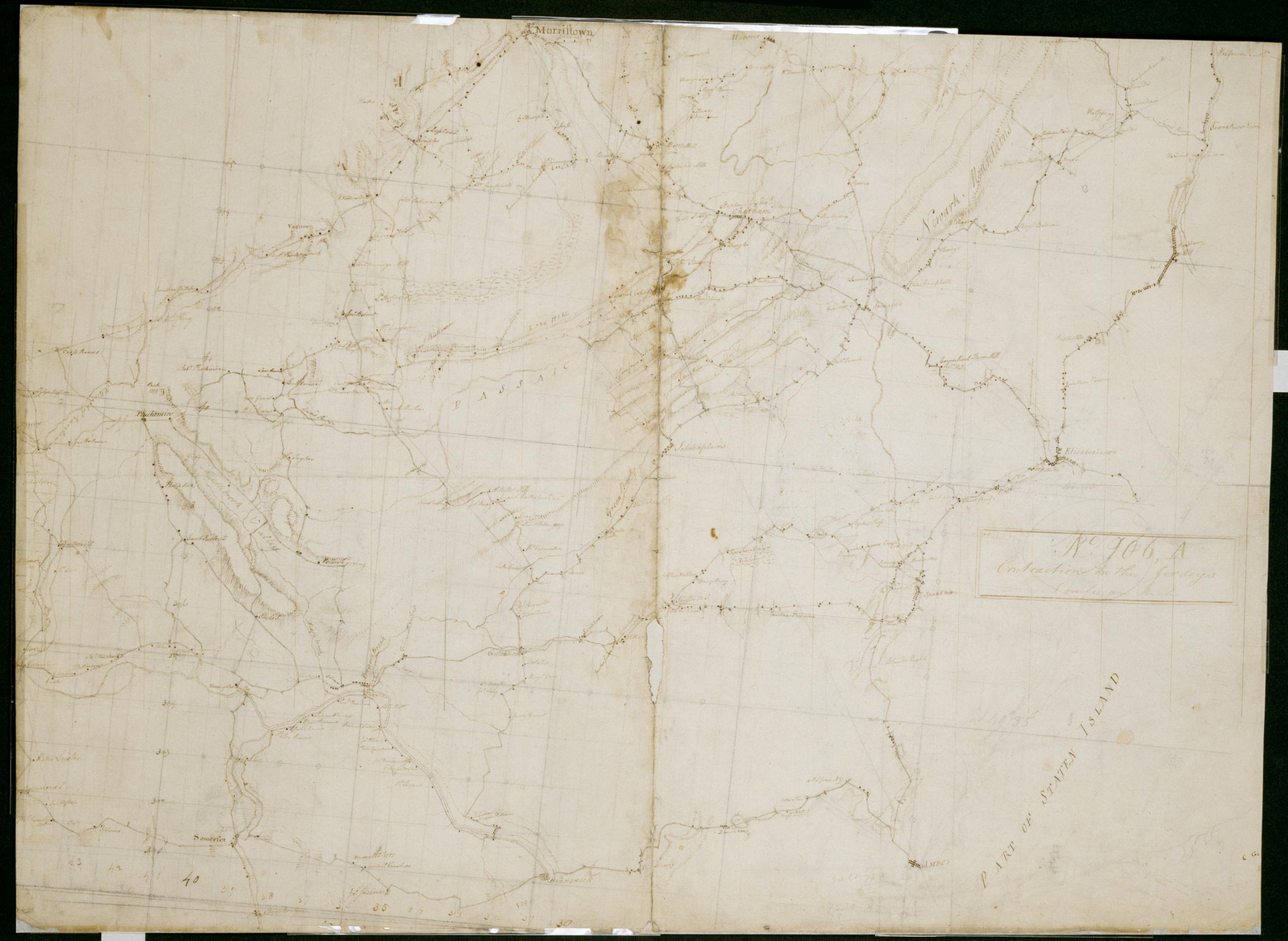
Cartographic Contraction in the Jerseys 1 mile an Inch. No. 106, A / by S. DeWitt A.B. ; by Robert Erskine F.R.S. Geogr. A. U.S. and Assistants. Imperfect: lacking 6 x 1 cm. at lower center of sheet. In ink on verso "No- 106- A". In pencil on recto: "No 106 A". Military topographic map. Covers the counties of Middlesex, Union, Essex, Somerset and Morris in New Jersey. Shows buildings and owners' names, landforms and streams. Pen-and-ink, pencil on laid paper. Shows relief by hachures. Stained, creased, frayed and abraded. Mounted on cloth, bound and cropped, disbound and silked by subsequent owners. Cleaned after removal of backings 1999; re-backed with China paper. Sheathed in mylar. View Item
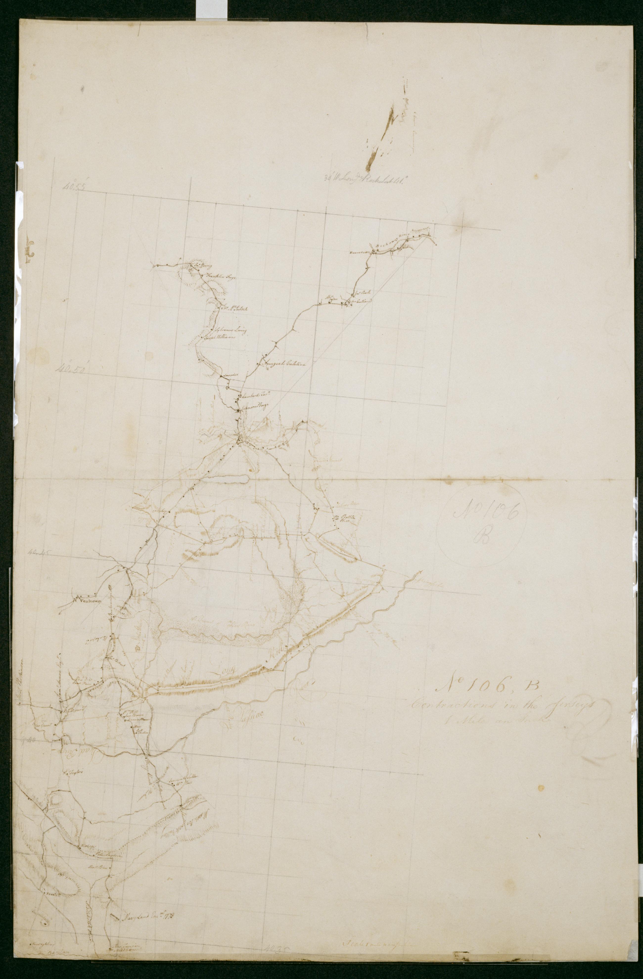
Cartographic Contractions in the Jerseys 1 Mile an Inch. No 106, B / by S. DeWitt A.B. ; by Robert Erskine F.R.S. Geogr. A. U.S. and Assistants. Imperfect: lacking 1 x 4 cm. at center of sheet. In ink on verso "No 106 B B B". In pencil on recto: "No 106 B". Military topographic map. Covers the counties of Union, Somerset and Morris in New Jersey. Shows buildings and owners' names, landforms and streams. Also shows position of "Maryland Enc[ampmen]t 1778." Pen-and-ink, pencil on laid paper. Shows relief by hachures. Stained, creased, frayed and abraded. Mounted on cloth, bound and cropped, disbound and silked by subsequent owners. Cleaned after removal of backings 1999; re-backed with China paper. Sheathed in mylar. View Item
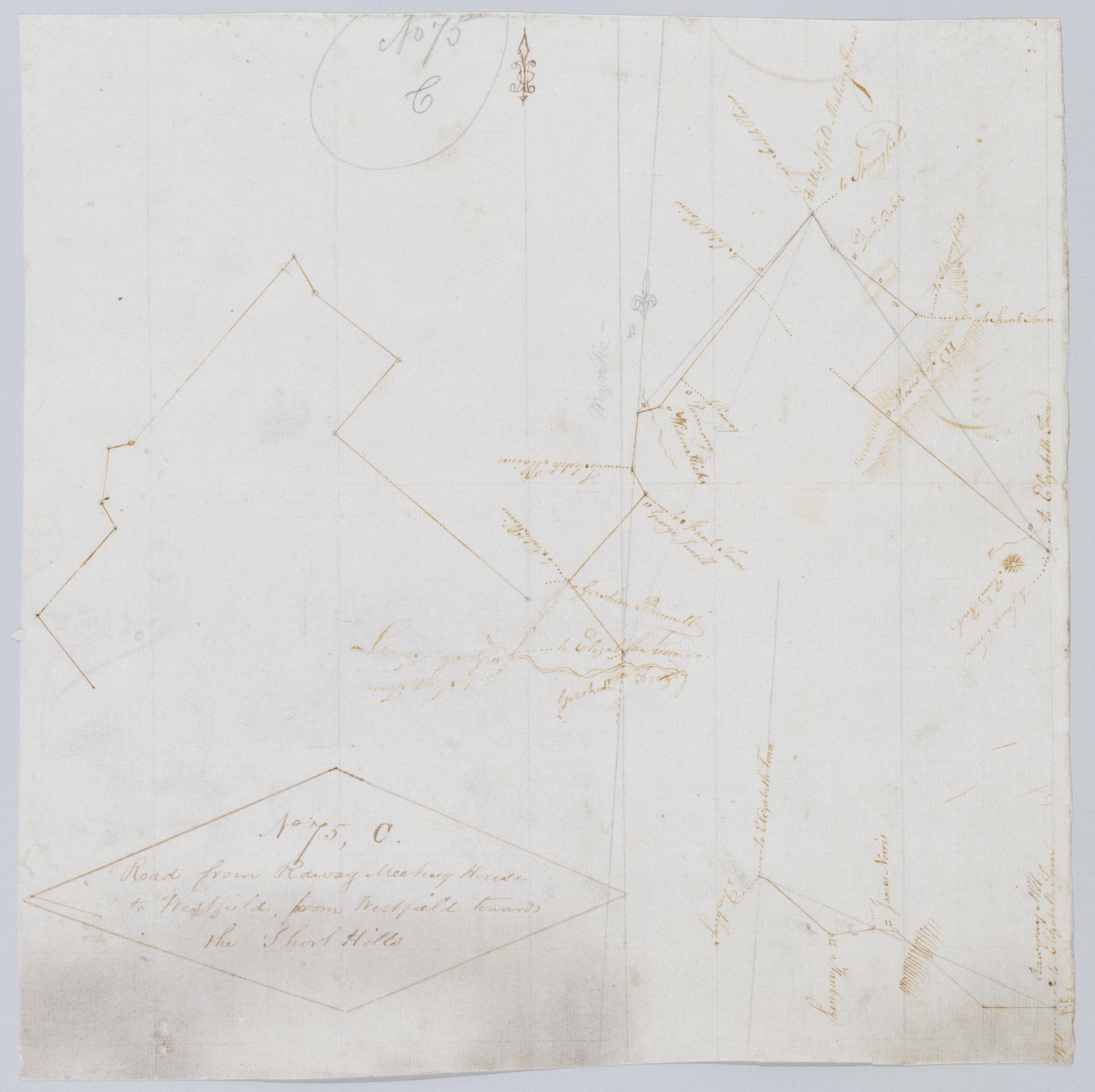
Cartographic Road from Raway Meeting House to Westfield, from Westfield towards the Short Hills. No 75, C / by Robert Erskine F.R.S. Geogr. A. U.S. and Assistants. In pencil on recto: "No 75 C." On verso: "Good Good From Jany". Military topographic maps. Left map is an incomplete version of that on the right; right map includes bottom segment, which joins it at lower right. Map covers the townships of Westfield, Clark, Rahway and Fanwood in Union County, New Jersey. It shows roads running through Rahway and Westfield. Also shows buildings and owners' names, landforms and streams. Pen-and-ink, pencil on laid paper. Shows relief by hachures. Soiled, stained, creased and abraded. View Item
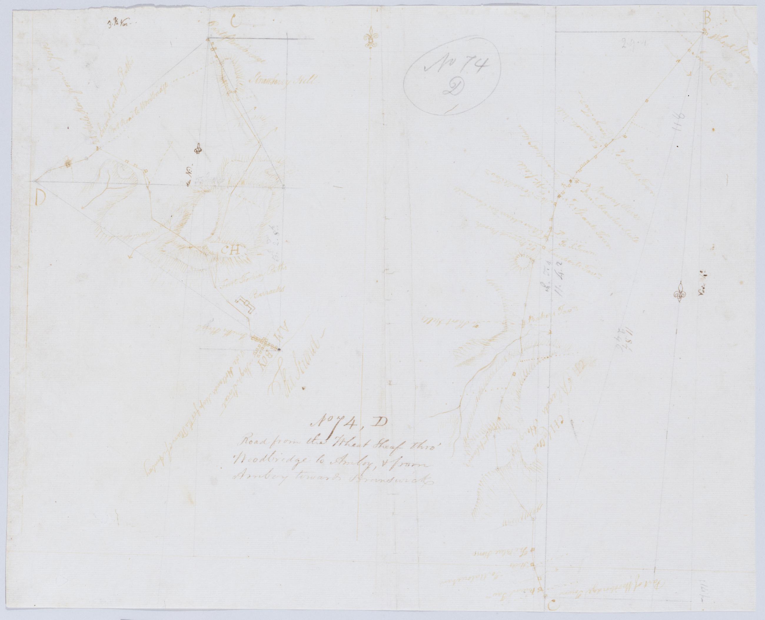
Cartographic Road from the Wheat Sheaf thro' Woodbridge to Amboy, + from Amboy towards Brunswick. No 74, D / by Robert Erskine F.R.S. Geogr. A. U.S. and Assistants. Foxed, creased, frayed and abraded. Mounted on cloth, bound and cropped, disbound and silked by subsequent owners. Cleaned after removal of backings 1999; some fill remains. Sheathed in mylar. In pencil on recto: "No 74 D". Military topographic map; righthand segment fits north of the lefthand one. Map covers the townships of Rahway and Linden in Union County and of Woodbridge in Middlesex County, New Jersey. Shows roads running through Wheatsheaf, Rahway, Demorest, Woodbridge, Spa Spring, Amboy, Fairfield Union and Valentine Fords. View Item
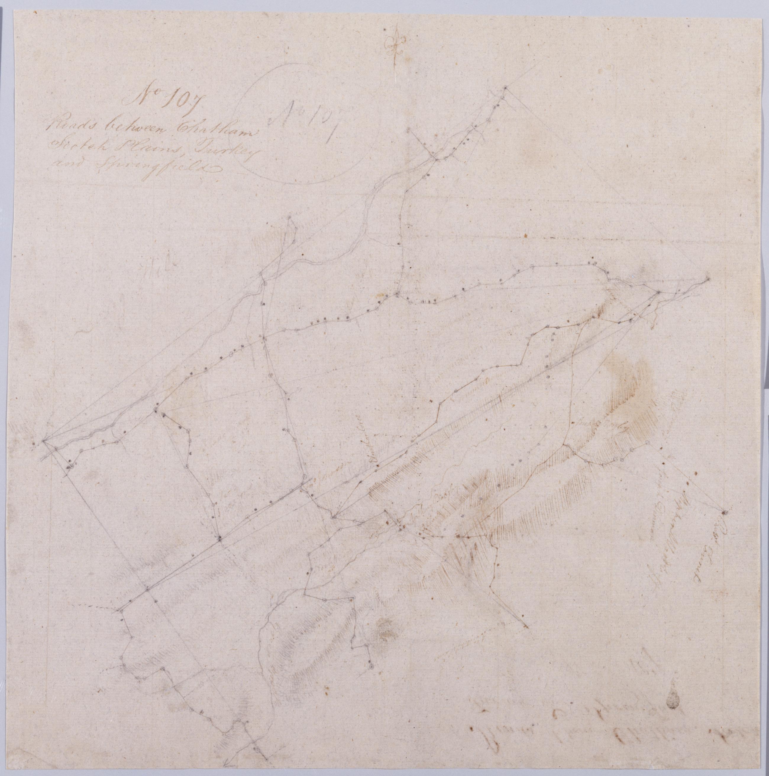
Cartographic Roads between Chatham Scotch Plains, Turkey and Springfield. No 107 / by Robert Erskine F.R.S. Geogr. A. U.S. and Assistants. In pencil on recto: "No 107". Military topographic map. Covers the townships of Summit, Springfield, Providence, Westfield, Fanwood and North Plainfield in Union County, New Jersey. Shows buildings and owners' names, landforms and streams. Pen-and-ink, pencil on laid paper. Title proper from recto is the work of a later editor--Simeon DeWitt or his assign--subsequent to 1820. Title from verso is in Erskine's hand and may be cited as such. Index title, statement of responsibility, date, series title and series numbering also by Erskine, but on separate index sheet filed at head of series. View Item
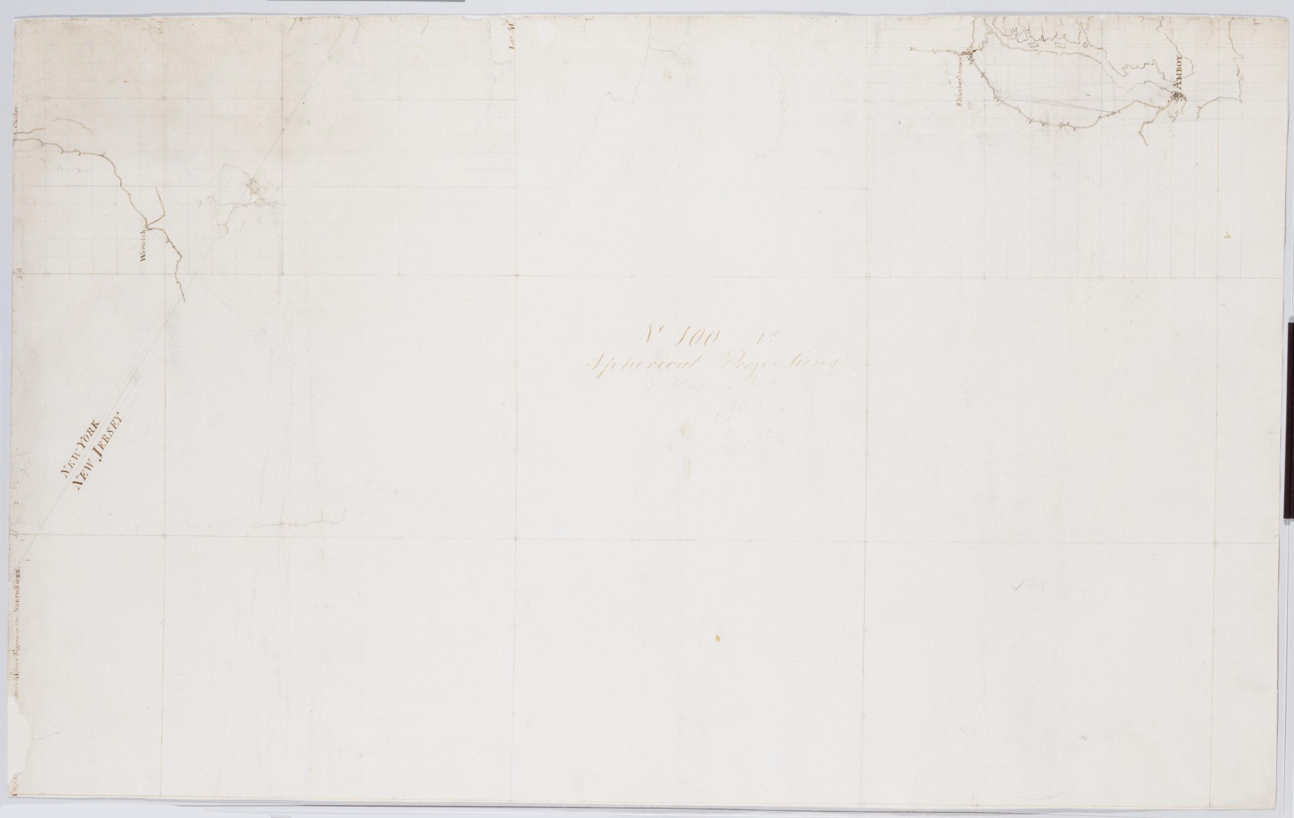
Cartographic Spherical Projections. No 100 / by R.E. ; by Robert Erskine F.R.S. Geogr. A. U.S. and Assistants, second sheet Collection of unfinished military topographic maps. The coordinates describe much of New Jersey but, aside from the coordinate grid itself, only small areas about Elizabethtown and Amboy, New Jersey, and about Warwick and Chester, New York, were ever mapped onto it. Title proper from recto of 1st sheet is the work of a later editor--Simeon DeWitt or his assign--subsequent to 1820. Index title, both statements of responsibility, date, scale statement, series title and series numbering by Erskine, but on separate index sheet filed at head of series. Pen-and-ink, pencil on laid paper. View Item
Cartographic Spherical Projections. No 100 / by R.E. ; by Robert Erskine F.R.S. Geogr. A. U.S. and Assistants, first sheet Collection of unfinished military topographic maps. The coordinates describe much of New Jersey but, aside from the coordinate grid itself, only small areas about Elizabethtown and Amboy, New Jersey, and about Warwick and Chester, New York, were ever mapped onto it. Title proper from recto of 1st sheet is the work of a later editor--Simeon DeWitt or his assign--subsequent to 1820. Index title, both statements of responsibility, date, scale statement, series title and series numbering by Erskine, but on separate index sheet filed at head of series. Pen-and-ink, pencil on laid paper. View Item
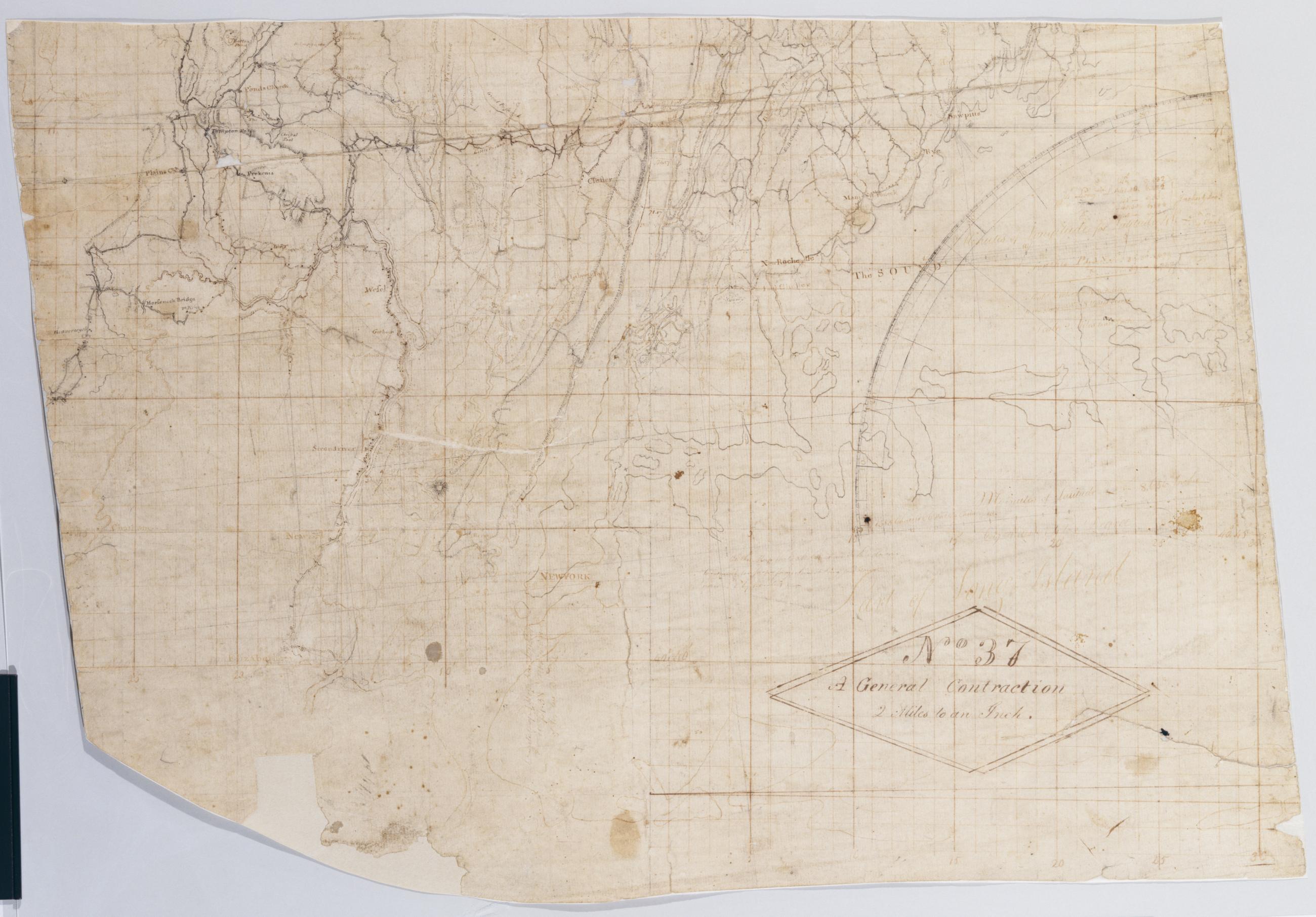
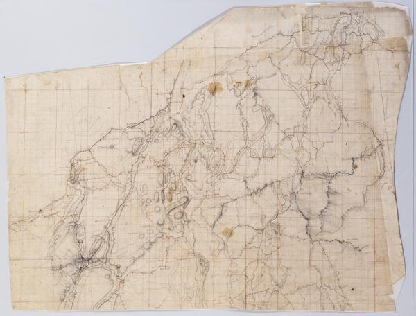
Cartographic A General Contraction 2 Miles to an Inch. No 37 / by R.E. ; by Robert Erskine F.R.S. Geogr. A. U.S. and Assistants, bottom Military topographic map. Covers the lower Hudson River Valley in New York, New Jersey and Connecticut, from Warwick (N.Y.) and Pompton Plains (N.J.) to New Milford and Danbury (Conn.), and from Newburgh (N.Y.) to Staten Island (N.Y.). Shows roads, buildings and owners' names, also landforms and streams. Shows relief by hachures. Title proper from recto is the work of a later editor--Simeon DeWitt or his assign--subsequent to 1820. Index title, both statements of responsibility, date, series title and series numbering by Erskine, but on separate index sheet filed at head of series. View Item
Cartographic A General Contraction 2 Miles to an Inch. No 37 / by R.E. ; by Robert Erskine F.R.S. Geogr. A. U.S. and Assistants, top Military topographic map. Covers the lower Hudson River Valley in New York, New Jersey and Connecticut, from Warwick (N.Y.) and Pompton Plains (N.J.) to New Milford and Danbury (Conn.), and from Newburgh (N.Y.) to Staten Island (N.Y.). Shows roads, buildings and owners' names, also landforms and streams. Shows relief by hachures. Title proper from recto is the work of a later editor--Simeon DeWitt or his assign--subsequent to 1820. Index title, both statements of responsibility, date, series title and series numbering by Erskine, but on separate index sheet filed at head of series. View Item
Image Cartographic 2 Items Spherical Projections. No 100 / by R.E. ; by Robert Erskine F.R.S. Geogr. A. U.S. and Assistants, first sheet Collection of unfinished military topographic maps. The coordinates describe much of New Jersey but, aside from the coordinate grid itself, only small areas about Elizabethtown and Amboy, New Jersey, and about Warwick and Chester, New York, were ever mapped onto it. Title proper from recto of 1st sheet is the work of a later editor--Simeon DeWitt or his assign--subsequent to 1820. Index title, both statements of responsibility, date, scale statement, series title and series numbering by Erskine, but on separate index sheet filed at head of series. Pen-and-ink, pencil on laid paper. View Item
Image Cartographic 2 Items A General Contraction 2 Miles to an Inch. No 37 / by R.E. ; by Robert Erskine F.R.S. Geogr. A. U.S. and Assistants. Military topographic map. Covers the lower Hudson River Valley in New York, New Jersey and Connecticut, from Warwick (N.Y.) and Pompton Plains (N.J.) to New Milford and Danbury (Conn.), and from Newburgh (N.Y.) to Staten Island (N.Y.). Shows roads, buildings and owners' names, also landforms and streams. Shows relief by hachures. Title proper from recto is the work of a later editor--Simeon DeWitt or his assign--subsequent to 1820. Index title, both statements of responsibility, date, series title and series numbering by Erskine, but on separate index sheet filed at head of series. View Item
Cartographic Road from Springfield to Elizabeth town. No 75 B / by Robert Erskine F.R.S. Geogr. A. U.S. and Assistants. Imperfect: 15 x 19 cm. at lower right corner cut out after drawing complete; compare cuts to those on 75-A. In pencil on recto: "No 75 B". Military topographic map; lower segment fits to the southeast of the upper one. Map covers the townships of Summit- Springfield and Union in Union County- New Jersey. Shows roads running through Springfield and Elizabeth. Also shows buildings and owners' names- landforms and streams. Pen-and-ink- pencil on laid paper. Shows relief by hachures. Stained- creased and abraded. Mounted on cloth- bound and cropped- disbound and silked by subsequent owners. View Item
Cartographic From Wheat Sheaf on the York Post Road to Elizabethtown. No 74 C / by Robert Erskine F.R.S. Geogr. A. U.S. and Assistants. In pencil on recto: "No 74 C". Military topographic map. Covers the townships of Union and Linden in Union County- New Jersey. Shows roads running through Wheatsheaf- Linden and Elizabeth. Also shows buildings and owners' names- landforms and streams. Pen-and-ink- pencil on laid paper. Shows relief by hachures. Stained- creased- torn- frayed and abraded. Mounted on cloth- bound and cropped- disbound and silked by subsequent owners. Cleaned after removal of backings 1999; some fill remains. Sheathed in mylar. View Item
Cartographic From Elizabeth Town Point to Newark. No 79 A / by Robert Erskine F.R.S. Geogr. A. U.S. and Assistants ; this is surveyed by Mr. Lodge .... In ink on verso: "A" Numeral and title cropped off. In pencil on recto: "No 79 A". Includes annotation: "This is surveyed by Mr. Lodge See Rough Draught N.75.B A Most abominably Lazy Slovenly performance not to Survey such a Small piece over again or lay it down properly Witness RE F.R.S." Military topographic map. Covers part of Union and Essex counties in New Jersey. Shows roads running through Elizabeth and Newark. Also shows buildings and owners' names- landforms and streams. Pen-and-ink- pencil on laid paper. Shows relief by hachures. Stained- torn and abraded. View Item
Cartographic Road from the Short Hills to the Wheat Sheaf on the Post Road. No 74 B / by Robert Erskine F.R.S. Geogr. A. U.S. and Assistants. In pencil on recto: "No 74 B". Military topographic map. Covers the townships of Linden- Clark- Fanwood- Plainfield and Westfield in Union County and of Raritan in Middlesex County- New Jersey. Shows roads running through Willow Grove- Picton and Wheatsheaf. Also shows buildings and owners' names- landforms and streams. Pen-and-ink- pencil on laid paper. Shows relief by hachures. Stained- soiled- creased- torn- frayed and abraded. Mounted on cloth- bound and cropped- disbound and silked by subsequent owners. Cleaned after removal of backings 1999; some fill remains. Sheathed in mylar. View Item
Cartographic Road from near Morristown through Bottle Hill and Chatham towards Springfield. No 75 A / by Robert Erskine F.R.S. Geogr. A. U.S. and Assistants. Fragment of original title in ink on verso: "Roa....". Imperfect: 16 x 14 cm. at lower left corner cut out after title written on verso. In pencil on recto: "No 75 A". Military topographic map. Covers the townships of Morris and Chatham in Morris County- Milburn in Essex County and Union in Summit County- New Jersey. Shows roads running through Morristown and Chatham. Also shows buildings and owners' names- landforms and streams. Pen-and-ink- pencil on laid paper. Shows relief by hachures. Stained- foxed- creased and abraded. View Item
Cartographic Contraction in the Jerseys. No 98 B / Large Paper by Capt. Scull ; by Robert Erskine F.R.S. Geogr. A. U.S. and Assistants. Foxed- stained- soiled- creased- frayed and abraded. Mounted on cloth- bound and cropped- disbound and silked by subsequent owners. Cleaned after removal of backings 1999; some fill remains. Sheathed in mylar. In ink on verso "No. 98 B." In pencil on recto: "No. 98 B". Military topographic map. Covers parts of Middlesex- Somerset and Union counties in New Jersey. Also shows buildings and owners' names- landforms and streams. Pen-and-ink- pencil on laid paper. Scale as drawn 1 in. per mi. Shows relief by hachures. View Item
Cartographic From Elizabeth Town Point to Totowa : (2 Miles to an Inch) No 82 / by Robert Erskine F.R.S. Geogr. A. U.S. and Assistants. In pencil on recto: "No 82". Military topographic map. Covers parts of Passaic- Essex and Union counties in New Jersey. Shows roads running through Elizabeth- Newark- Belleville- Clifton- South Paterson and Totowa. Also shows buildings and owners' names- landforms and streams. Pen-and-ink- pencil on laid paper. Shows relief by hachures. Stained- soiled- frayed and abraded. Mounted on cloth- bound and cropped- disbound and silked by subsequent owners. Cleaned after removal of backings 1999; some fill remains. Sheathed in mylar. View Item
Cartographic From Short Hill to Spanktown and Craig's Tavern. No 78 / by Robert Erskine F.R.S. Geogr. A. U.S. and Assistants. In pencil on recto: "No 78". Includes inset map of same area at "2 Miles to an Inch" or 1:127-000. Military topographic map. Covers the townships of Rahway and Westfield in Union County and of Raritan and Woodbridge in Middlesex County- New Jersey. Shows roads running through Potters and Rahway (formerly Spanktown). Also shows buildings and owners' names- landforms and streams. Pen-and-ink- pencil on laid paper. Shows relief by hachures. Stained and abraded. Mounted on cloth- bound and cropped- disbound and silked by subsequent owners. View Item
Cartographic Contraction in the Jerseys 1 mile an Inch. No. 106 A / by S. DeWitt A.B. ; by Robert Erskine F.R.S. Geogr. A. U.S. and Assistants. Imperfect: lacking 6 x 1 cm. at lower center of sheet. In ink on verso "No- 106- A". In pencil on recto: "No 106 A". Military topographic map. Covers the counties of Middlesex- Union- Essex- Somerset and Morris in New Jersey. Shows buildings and owners' names- landforms and streams. Pen-and-ink- pencil on laid paper. Shows relief by hachures. Stained- creased- frayed and abraded. Mounted on cloth- bound and cropped- disbound and silked by subsequent owners. Cleaned after removal of backings 1999; re-backed with China paper. Sheathed in mylar. View Item
Cartographic Contractions in the Jerseys 1 Mile an Inch. No 106 B / by S. DeWitt A.B. ; by Robert Erskine F.R.S. Geogr. A. U.S. and Assistants. Imperfect: lacking 1 x 4 cm. at center of sheet. In ink on verso "No 106 B B B". In pencil on recto: "No 106 B". Military topographic map. Covers the counties of Union- Somerset and Morris in New Jersey. Shows buildings and owners' names- landforms and streams. Also shows position of "Maryland Enc[ampmen]t 1778." Pen-and-ink- pencil on laid paper. Shows relief by hachures. Stained- creased- frayed and abraded. Mounted on cloth- bound and cropped- disbound and silked by subsequent owners. Cleaned after removal of backings 1999; re-backed with China paper. Sheathed in mylar. View Item
Cartographic Road from Raway Meeting House to Westfield from Westfield towards the Short Hills. No 75 C / by Robert Erskine F.R.S. Geogr. A. U.S. and Assistants. In pencil on recto: "No 75 C." On verso: "Good Good From Jany". Military topographic maps. Left map is an incomplete version of that on the right; right map includes bottom segment- which joins it at lower right. Map covers the townships of Westfield- Clark- Rahway and Fanwood in Union County- New Jersey. It shows roads running through Rahway and Westfield. Also shows buildings and owners' names- landforms and streams. Pen-and-ink- pencil on laid paper. Shows relief by hachures. Soiled- stained- creased and abraded. View Item