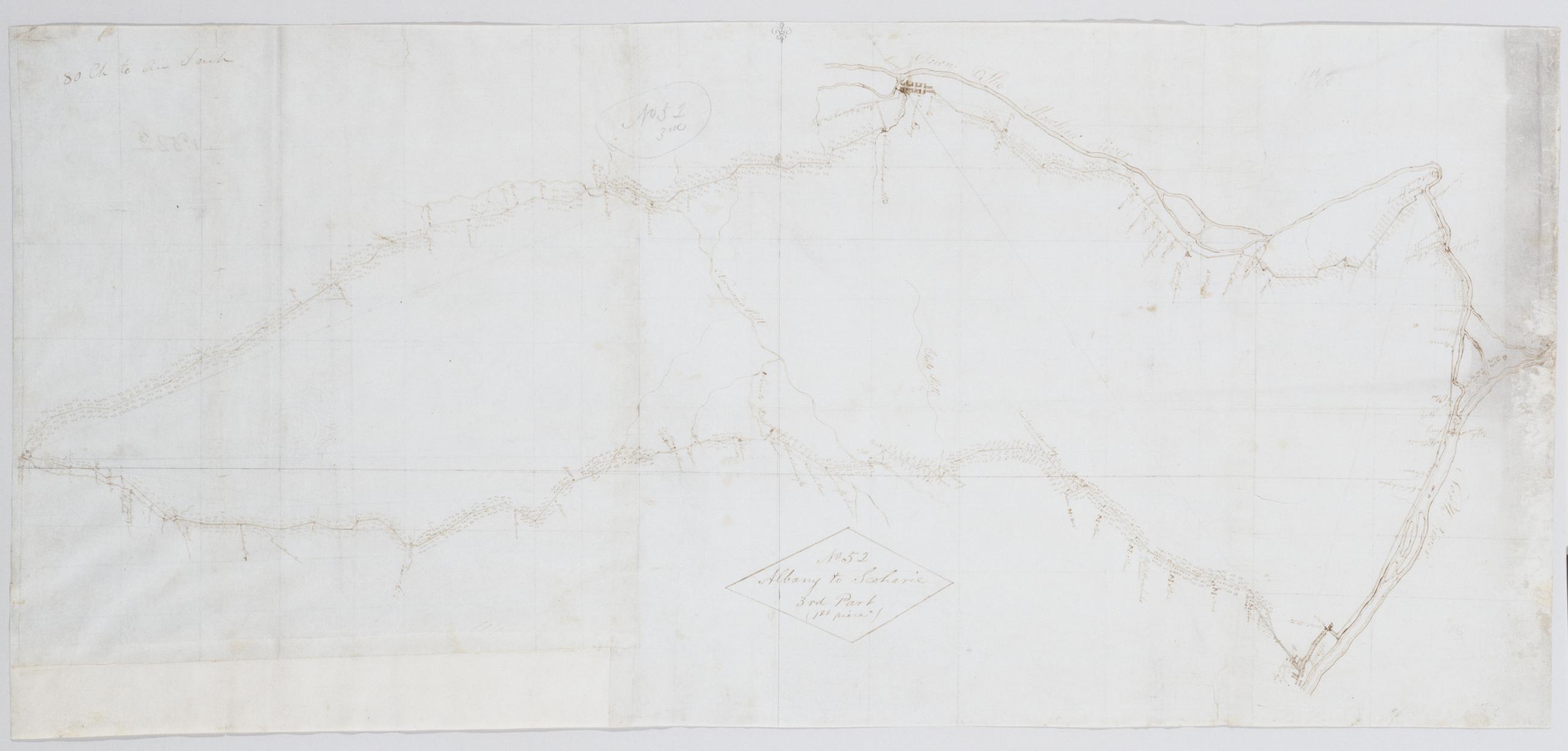
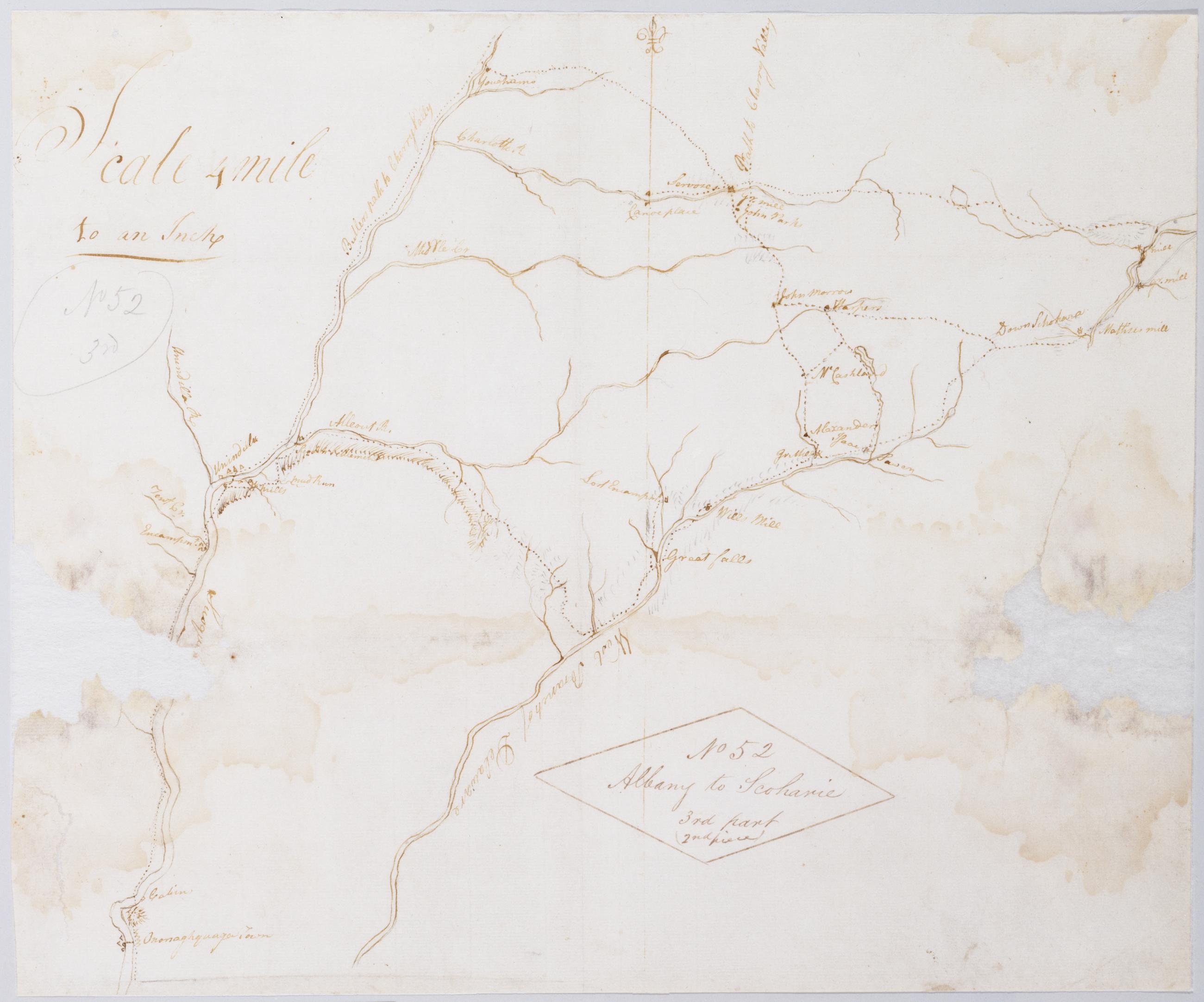
Cartographic Albany to Scoharie. No 52 3rd Part (1st piece) [sic]/ by Robert Erskine F.R.S. Geogr. A. U.S. and Assistants ; by Capt. Gray. Foxed, soiled, frayed, and abraded. Mounted on cloth, bound and cropped, disbound and silked by subsequent owners. Cleaned after removal of backings 1999; some fill remains. Sheathed in mylar. In pencil on recto and in ink on verso is written, incorrectly, "No. 52 3d" However, the handwriting is in neither case Erskine's. Index title, both statements of responsbility, date, series title and series numbering by Erskine, but on separate index sheet filed at head of series. Military topographic map. Covers the counties of Albany, Schenectady and Scoharie, New York. View Item
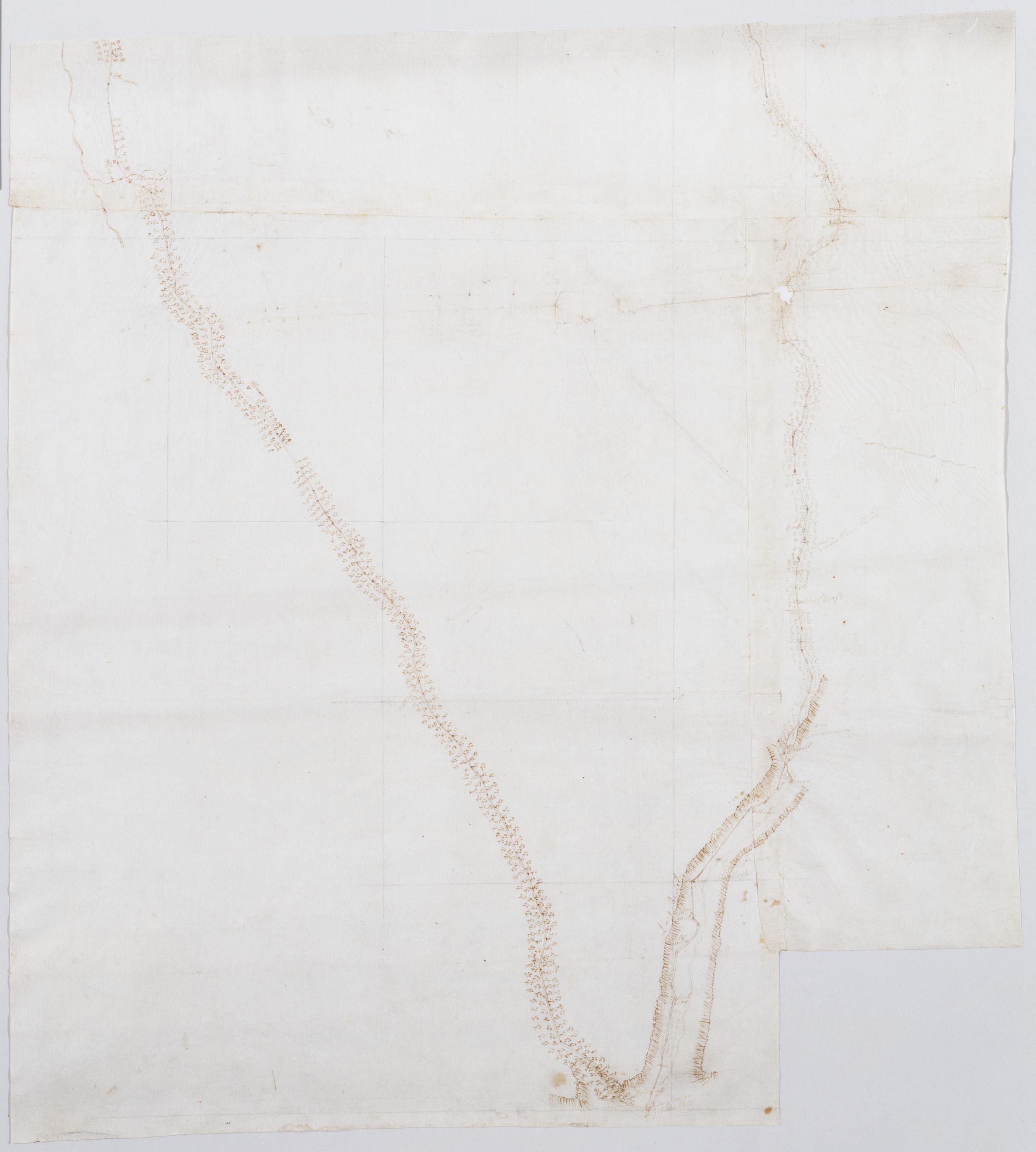
Cartographic Albany to Scoharie [sic] No 52 3rd Part (2nd piece) [sic] / by Robert Erskine F.R.S. Geogr. A. U.S. and Assistants. Index title by Erskine: Part of the Susquehanna & Delaware; Ononoughquago &c. 65. Drawing attributed to Gray based on comparison to another map in this series titled "Draught of Part of Schohara Part of the West Branch of Delaware & Part of Susquehanna Rivers...." That map includes the text, "N.B. Schohara is taken from Actual Survey the others only from Sight & Information." The sheet in hand appears to be the drawing made "only from Sight & Information." Imperfect: lacking 7 x 7 cm. at left margin, 6 x 8 cm. at right margin. View Item
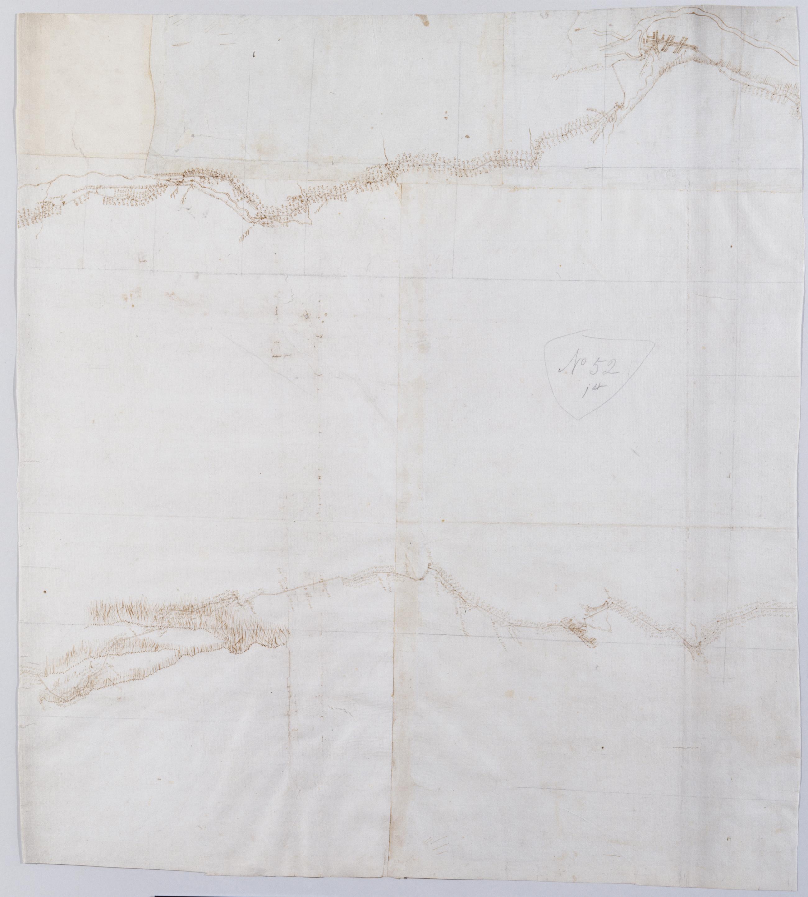
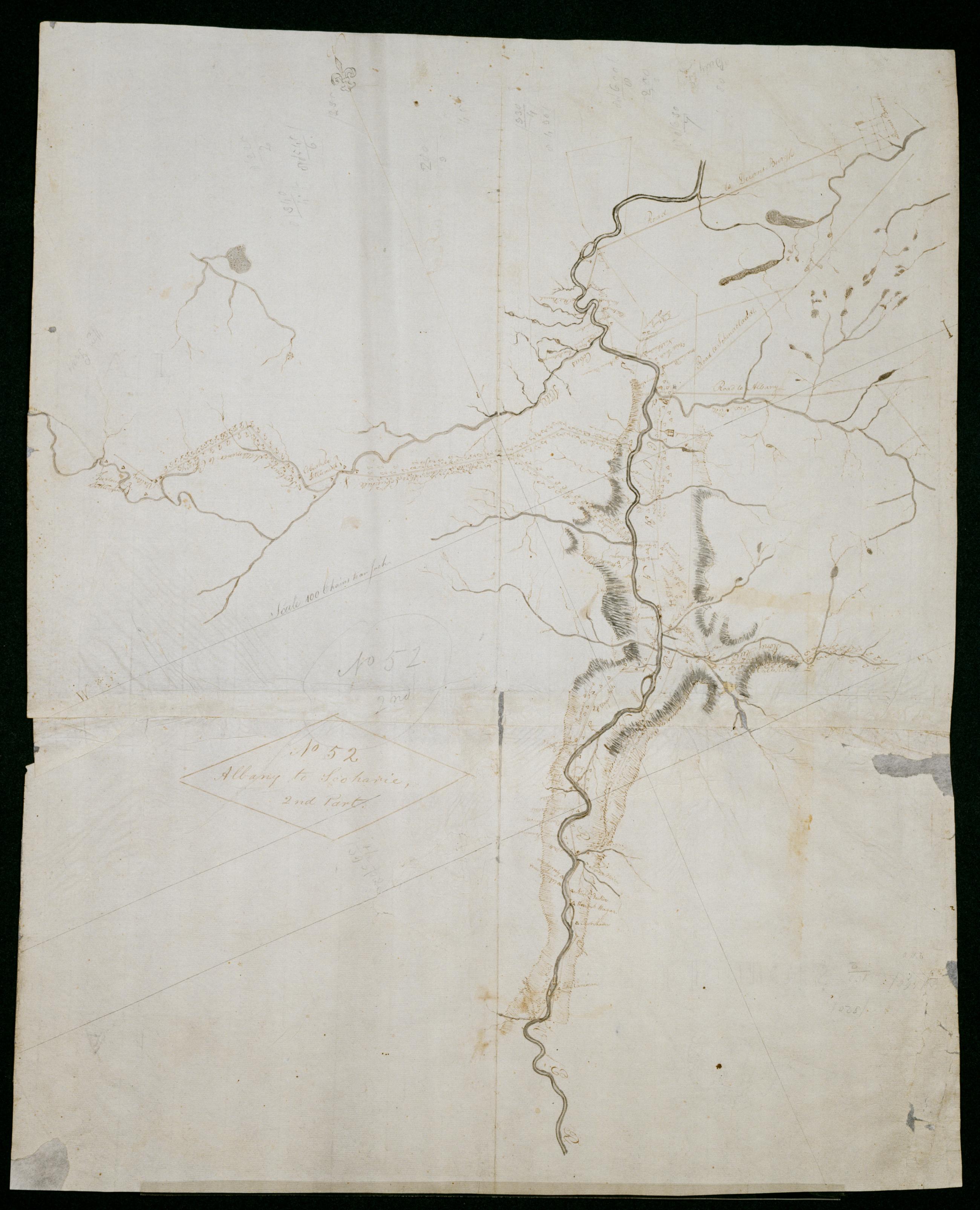
Cartographic Albany to Scoharie [sic]. No 52 2nd Part [sic] / by Robert Erskine F.R.S. Geogr. A. U.S. and Assistants. Index title by Erskine: Part of the Susquehanna & Delaware; Ononoughquago &c. 65. Drawing attributed to Gray based on comparison to another map in this series titled "Draught of part of Schohara Part of the West Branch of Delaware & Part of Susquehanna Rivers...." That map includes the text, "N.B. Schohara is taken from Actual Survey the others only from Sight & Information." The sheet in hand appears to be the "Actual Survey." Foxed, soiled, creased, frayed, and abraded. Mounted on cloth, bound and cropped, disbound and silked by subsequent owners. View Item
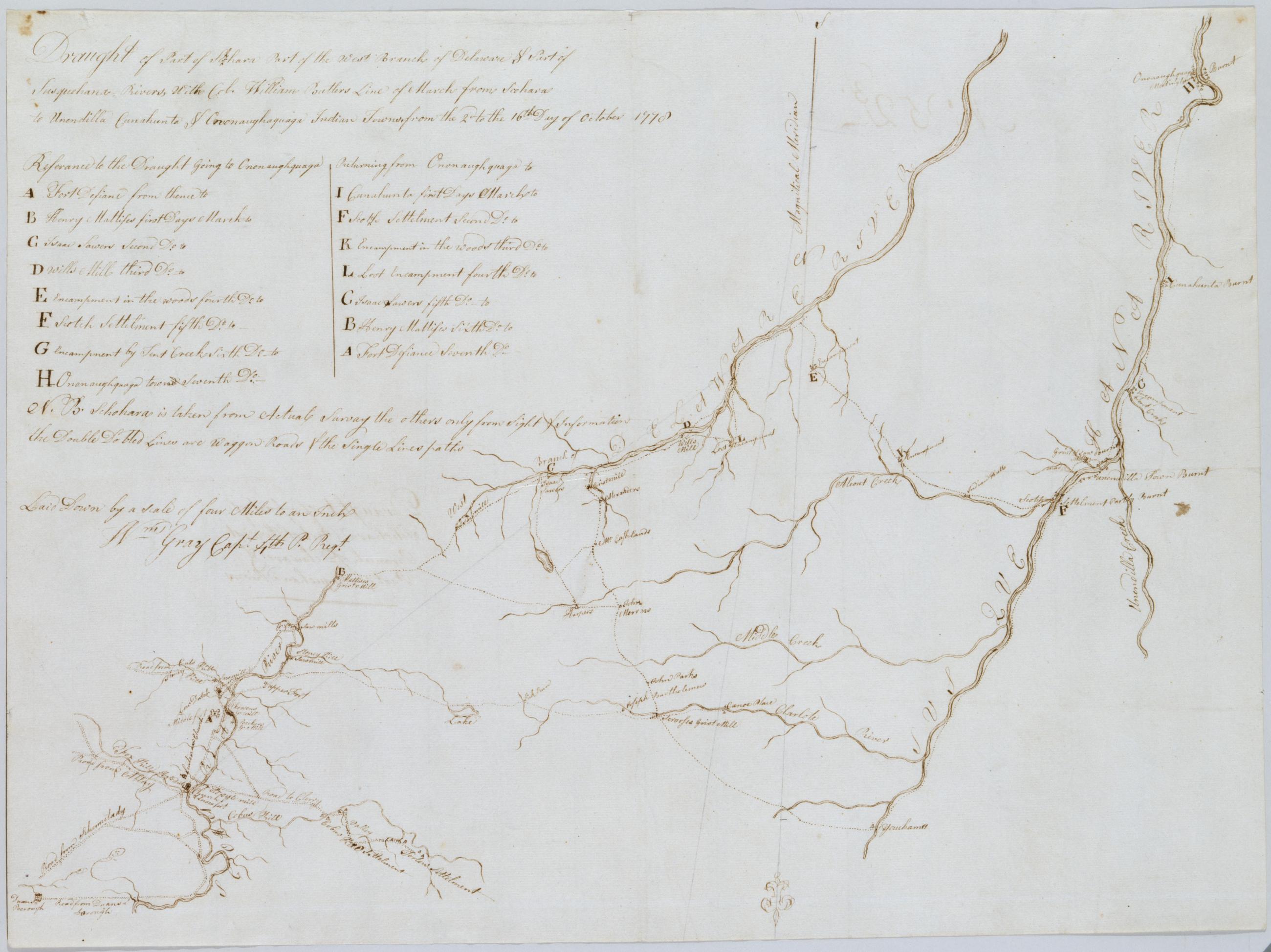
Cartographic Draught of Part of Schohara Part of the West Branch of Delaware & Part of Susquehana Rivers With Col. William Butlers Line of March from Schohara to Unendilla Cunahunta & Ononaughaquaga Indian Towns from the 2d to the 16th Day of October 1778 / by Robert Index title: Part of the Susquehanna & Delaware; Ononoughquago &c. 65. Foxed, creased, frayed and lightly soiled. Sheathed in mylar. Includes a day by day key to Butler's march. Includes text: "N.B. Schohara is taken from Actual Survey the others only from Sight & Information the Double Dotted Lines are Waggon Roads & the Single Lines paths". Military topographic map. Covers Chenango, Delaware, Otsego, Schoharie and Schenectady counties in New York. View Item
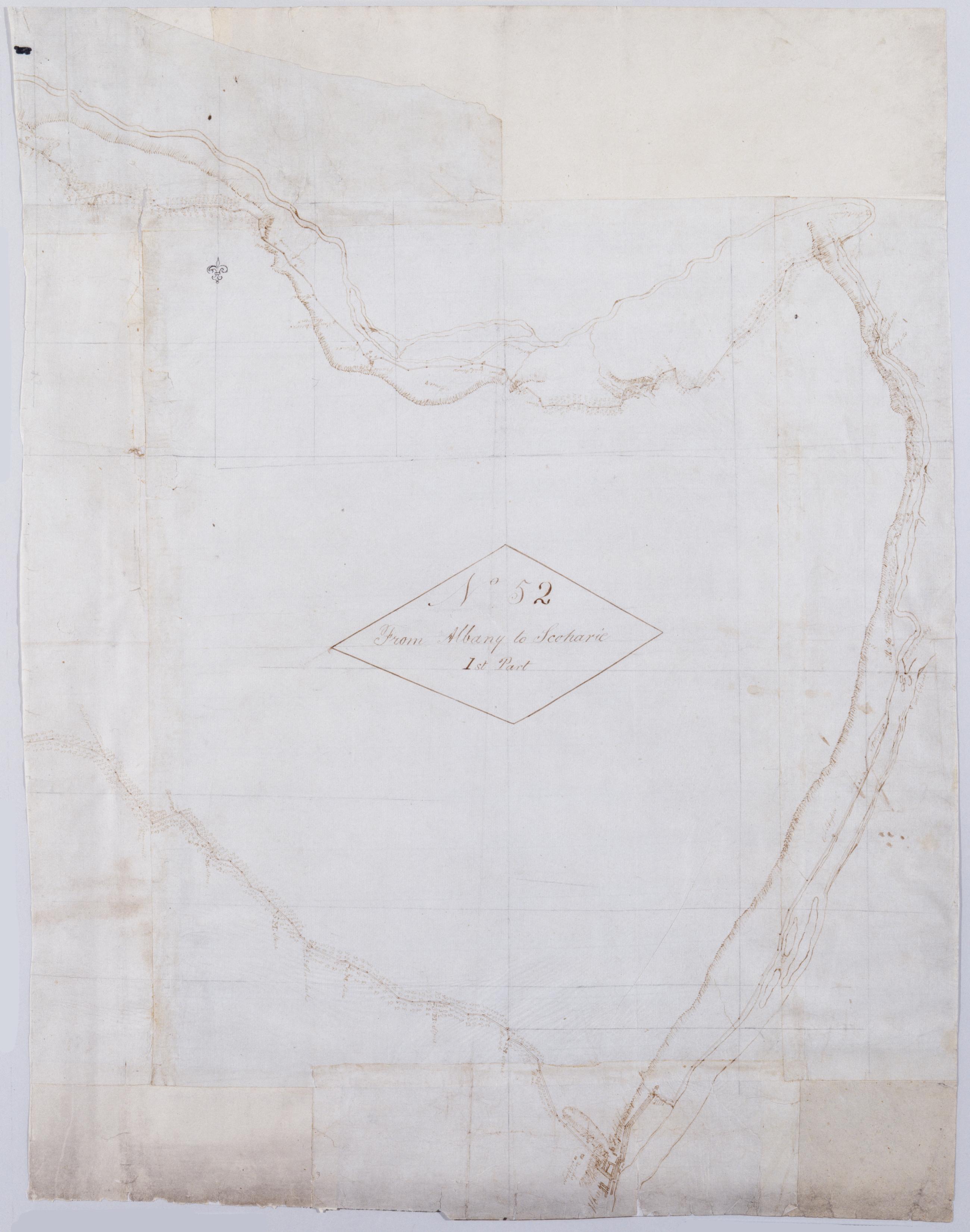
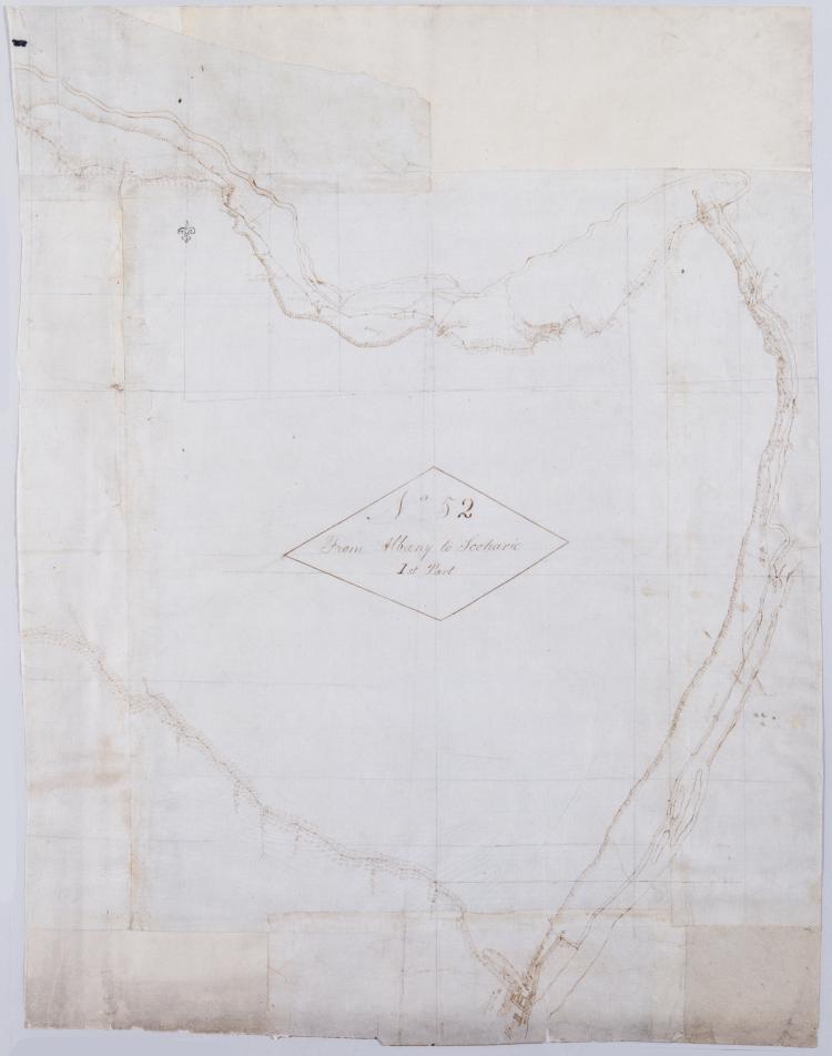
Cartographic From Albany to Scoharie. No 52 1st Part [sic] / by Robert Erskine F.R.S. Geogr. A. U.S. and Assistants ; by Capt. Gray, second sheet Military topographic map. Covers the counties of Albany, Schenectady and Scoharie, New York. Shows roads running through Albany, Westmere, Guilderland, Hartmans Corners, Guilderland Center, Altamont, Knox, Gallupville, Shutter Corners and, just north of Schoharie, Vrooman Corners; also Quaker Street, Duanesburg, Princeton or Kelley Station, Rotterdam, Schnectady, Hawthorne Hill, Niskayuna, Freligh, Crescent Station to near Crescent, Cohoes and Watervliet. Map also shows buildings and owners' names, landforms and streams. Shows relief by hachures. View Item
Cartographic From Albany to Scoharie. No 52 1st Part [sic] / by Robert Erskine F.R.S. Geogr. A. U.S. and Assistants ; by Capt. Gray, first sheet Military topographic map. Covers the counties of Albany, Schenectady and Scoharie, New York. Shows roads running through Albany, Westmere, Guilderland, Hartmans Corners, Guilderland Center, Altamont, Knox, Gallupville, Shutter Corners and, just north of Schoharie, Vrooman Corners; also Quaker Street, Duanesburg, Princeton or Kelley Station, Rotterdam, Schnectady, Hawthorne Hill, Niskayuna, Freligh, Crescent Station to near Crescent, Cohoes and Watervliet. Map also shows buildings and owners' names, landforms and streams. Shows relief by hachures. View Item
Cartographic From Albany to Scoharie. No 52 1st Part [sic] / by Robert Erskine F.R.S. Geogr. A. U.S. and Assistants ; by Capt. Gray, third sheet Military topographic map. Covers the counties of Albany, Schenectady and Scoharie, New York. Shows roads running through Albany, Westmere, Guilderland, Hartmans Corners, Guilderland Center, Altamont, Knox, Gallupville, Shutter Corners and, just north of Schoharie, Vrooman Corners; also Quaker Street, Duanesburg, Princeton or Kelley Station, Rotterdam, Schnectady, Hawthorne Hill, Niskayuna, Freligh, Crescent Station to near Crescent, Cohoes and Watervliet. Map also shows buildings and owners' names, landforms and streams. Shows relief by hachures. View Item
Image Cartographic 3 Items From Albany to Scoharie. No 52 1st Part [sic] / by Robert Erskine F.R.S. Geogr. A. U.S. and Assistants ; by Capt. Gray. Military topographic map. Covers the counties of Albany, Schenectady and Scoharie, New York. Shows roads running through Albany, Westmere, Guilderland, Hartmans Corners, Guilderland Center, Altamont, Knox, Gallupville, Shutter Corners and, just north of Schoharie, Vrooman Corners; also Quaker Street, Duanesburg, Princeton or Kelley Station, Rotterdam, Schnectady, Hawthorne Hill, Niskayuna, Freligh, Crescent Station to near Crescent, Cohoes and Watervliet. Map also shows buildings and owners' names, landforms and streams. Shows relief by hachures. View Item
Cartographic Albany to Scoharie. No 52 3rd Part (1st piece) [sic]/ by Robert Erskine F.R.S. Geogr. A. U.S. and Assistants ; by Capt. Gray. Foxed- soiled- frayed- and abraded. Mounted on cloth- bound and cropped- disbound and silked by subsequent owners. Cleaned after removal of backings 1999; some fill remains. Sheathed in mylar. In pencil on recto and in ink on verso is written- incorrectly- "No. 52 3d" However- the handwriting is in neither case Erskine's. Index title- both statements of responsbility- date- series title and series numbering by Erskine- but on separate index sheet filed at head of series. Military topographic map. Covers the counties of Albany- Schenectady and Scoharie- New York. View Item
Cartographic Albany to Scoharie [sic] No 52 3rd Part (2nd piece) [sic] / by Robert Erskine F.R.S. Geogr. A. U.S. and Assistants. Index title by Erskine: Part of the Susquehanna & Delaware; Ononoughquago &c. 65. Drawing attributed to Gray based on comparison to another map in this series titled "Draught of Part of Schohara Part of the West Branch of Delaware & Part of Susquehanna Rivers...." That map includes the text- "N.B. Schohara is taken from Actual Survey the others only from Sight & Information." The sheet in hand appears to be the drawing made "only from Sight & Information." Imperfect: lacking 7 x 7 cm. at left margin- 6 x 8 cm. at right margin. View Item
Cartographic Albany to Scoharie [sic]. No 52 2nd Part [sic] / by Robert Erskine F.R.S. Geogr. A. U.S. and Assistants. Index title by Erskine: Part of the Susquehanna & Delaware; Ononoughquago &c. 65. Drawing attributed to Gray based on comparison to another map in this series titled "Draught of part of Schohara Part of the West Branch of Delaware & Part of Susquehanna Rivers...." That map includes the text- "N.B. Schohara is taken from Actual Survey the others only from Sight & Information." The sheet in hand appears to be the "Actual Survey." Foxed- soiled- creased- frayed- and abraded. Mounted on cloth- bound and cropped- disbound and silked by subsequent owners. View Item
Cartographic Draught of Part of Schohara Part of the West Branch of Delaware & Part of Susquehana Rivers With Col. William Butlers Line of March from Schohara to Unendilla Cunahunta & Ononaughaquaga Indian Towns from the 2d to the 16th Day of October 1778 / by Robert Index title: Part of the Susquehanna & Delaware; Ononoughquago &c. 65. Foxed- creased- frayed and lightly soiled. Sheathed in mylar. Includes a day by day key to Butler's march. Includes text: "N.B. Schohara is taken from Actual Survey the others only from Sight & Information the Double Dotted Lines are Waggon Roads & the Single Lines paths". Military topographic map. Covers Chenango- Delaware- Otsego- Schoharie and Schenectady counties in New York. View Item
Cartographic From Albany to Scoharie. No 52 1st Part [sic] / by Robert Erskine F.R.S. Geogr. A. U.S. and Assistants ; by Capt. Gray. Military topographic map. Covers the counties of Albany- Schenectady and Scoharie- New York. Shows roads running through Albany- Westmere- Guilderland- Hartmans Corners- Guilderland Center- Altamont- Knox- Gallupville- Shutter Corners and- just north of Schoharie- Vrooman Corners; also Quaker Street- Duanesburg- Princeton or Kelley Station- Rotterdam- Schnectady- Hawthorne Hill- Niskayuna- Freligh- Crescent Station to near Crescent- Cohoes and Watervliet. Map also shows buildings and owners' names- landforms and streams. Shows relief by hachures. View Item