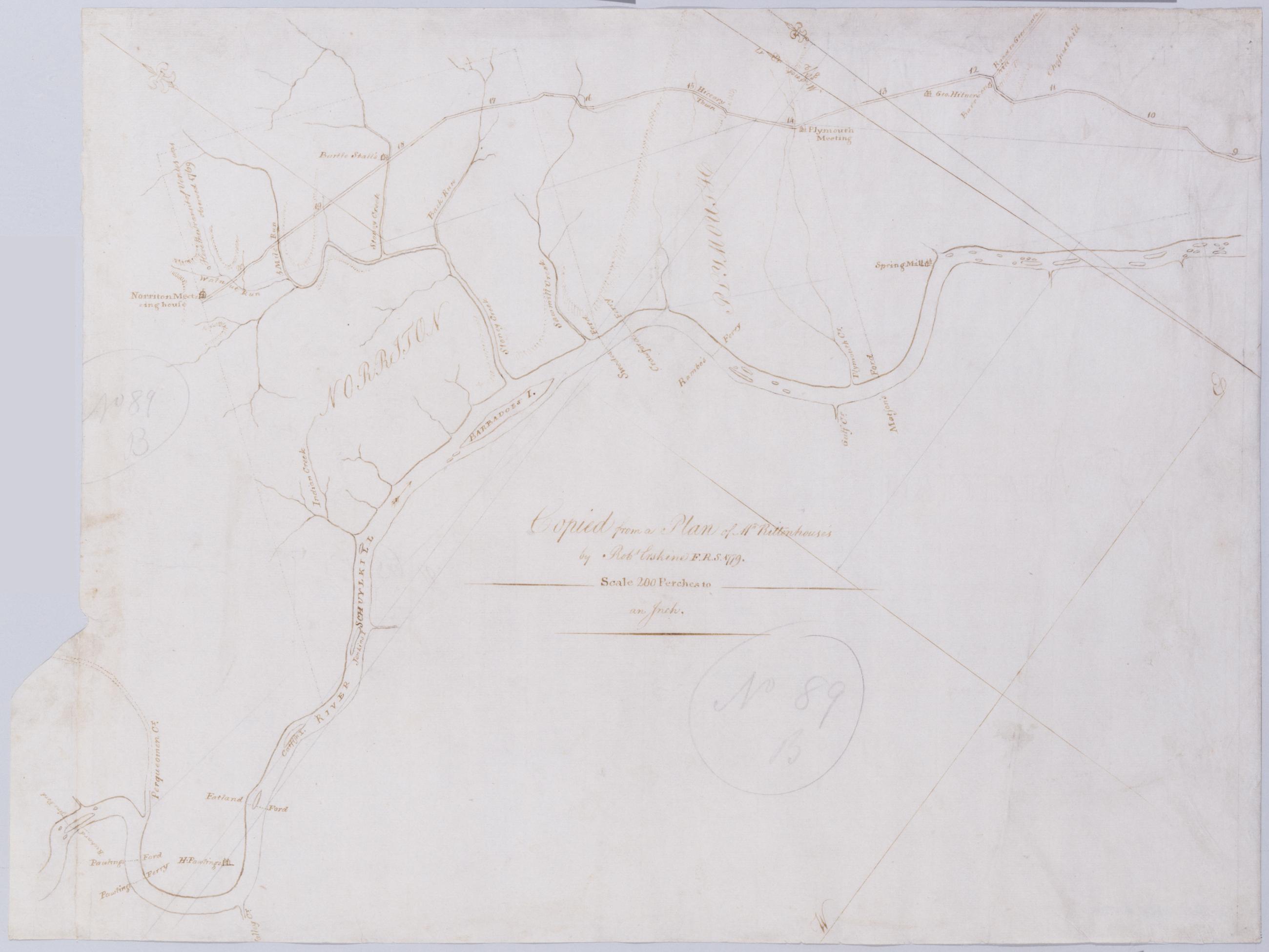
Cartographic [A Contraction of Do.] No. 89 B. / Copied from a Plan of Mr Rittenhouse's by Robt Erskine F.R.S. 1779 ; by Robert Erskine F.R.S. Geogr. A. U.S. and Assistants. Foxed, soiled, frayed. Sheathed in mylar. In ink on verso: "No. 89 B." In pencil on recto: "No 89 B". Military topographic map. Covers the counties of Chester, Montgomery and Delaware, Pennsylvania. Shows roads running through Norristown and Philadelphia. Also shows buildings and owners' names, landforms and streams. No title on recto or verso; title proper supplied by cataloger. Title number from map verso. First statement of responsibility from map recto. View Item
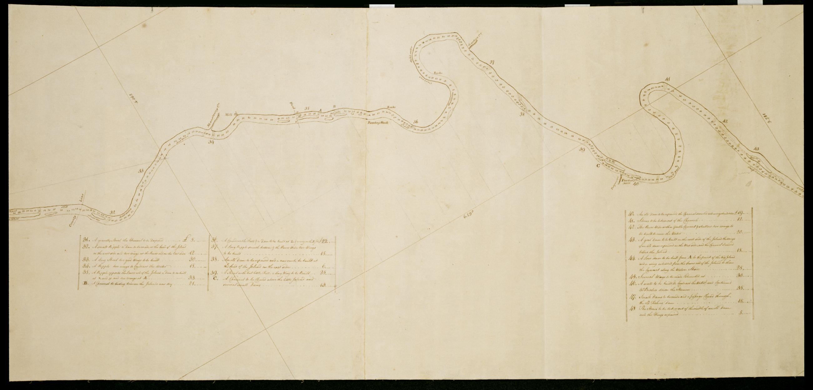
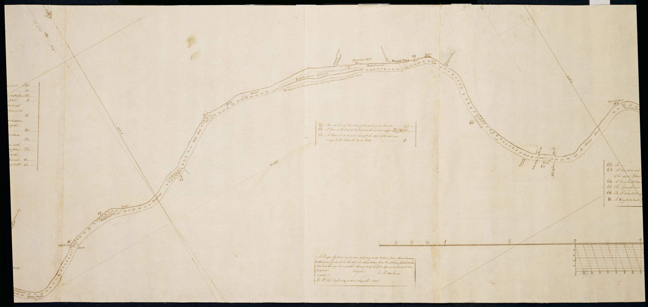
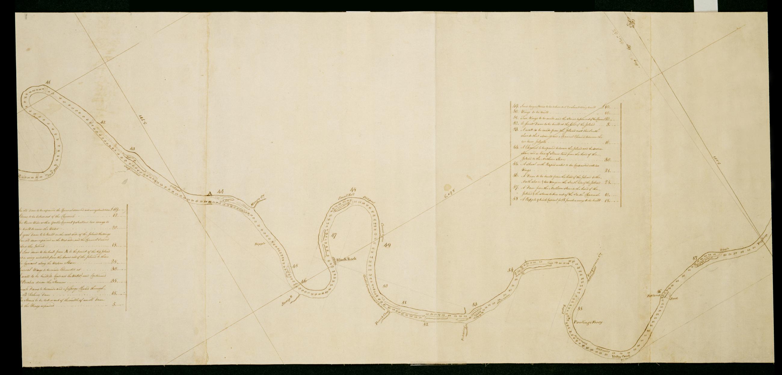
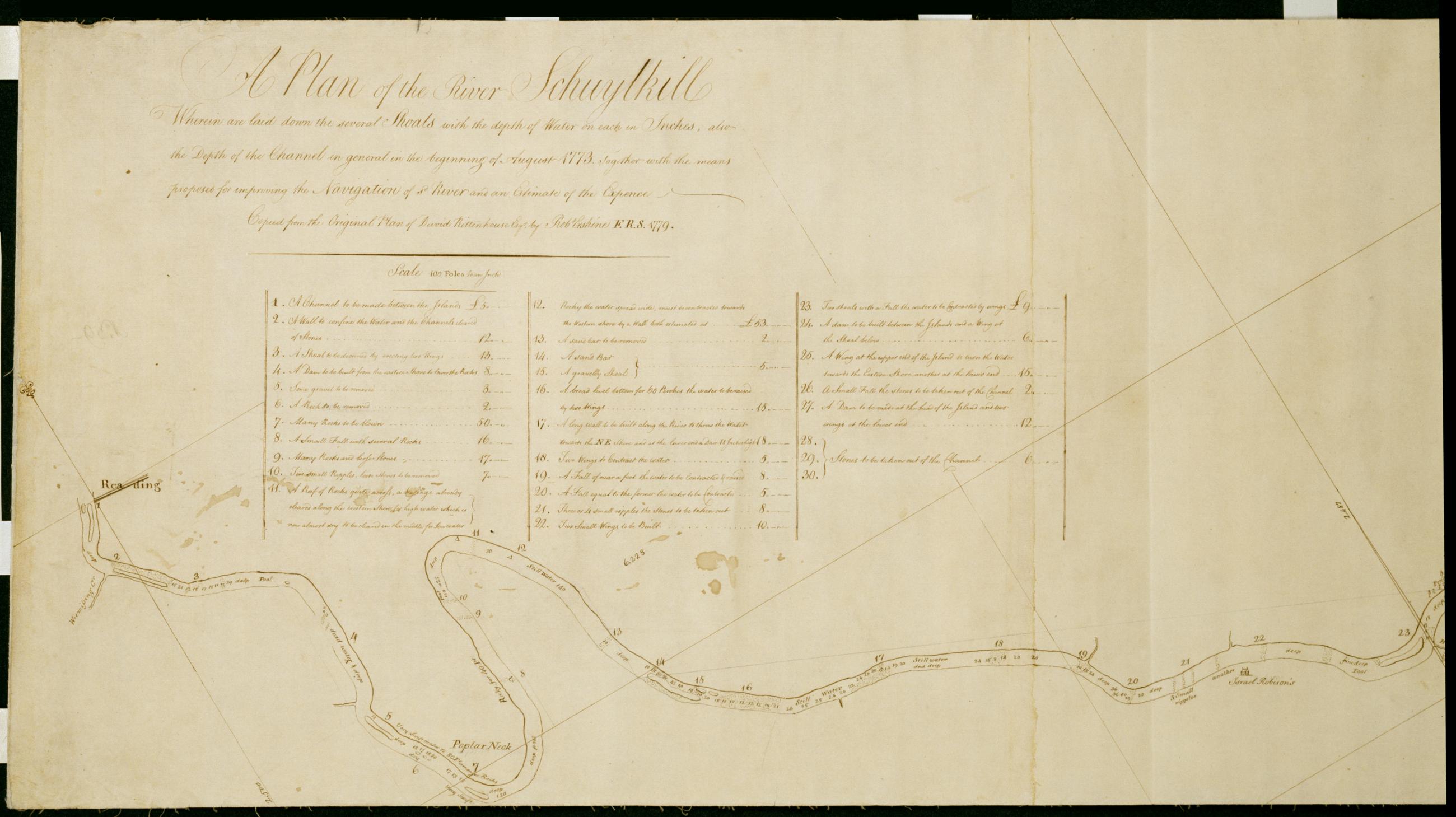
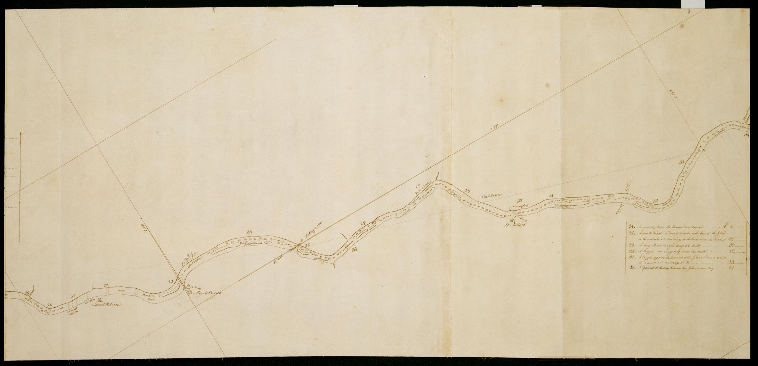
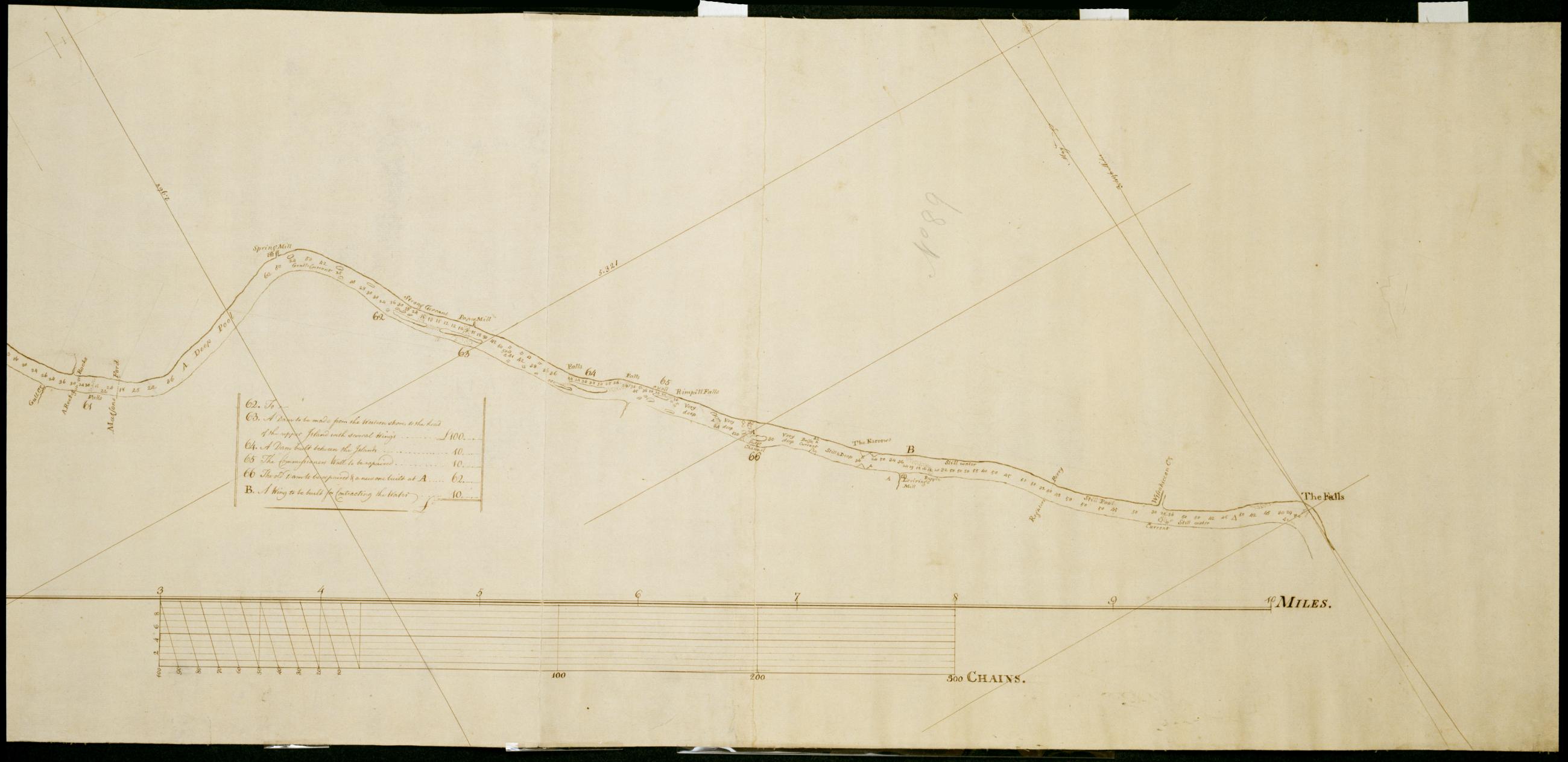
Cartographic A Plan of the River Schuylkill Wherein are laid down the several Shoals with the depth of Water on each in Inches, also the Depth of the Channel in general in the beginning of August 1773, Together with the means proposed for improving the Navigation of s Foxed, soiled, stained and creased. Mounted on cloth and cropped. In pencil on recto: "No 89". Includes index to 66 numbered features. Military topographic map. Covers the counties of Berks, Chester, Montgomery and Philadelphia, Pennsylvania, between Reading and Philadelphia. Shows river features and depths by soundings. Does not show landward features. Pen-and-ink, pencil on laid paper. Title proper and first statement of responsibility from map recto. Title number supplied by cataloger. View Item
Cartographic A Plan of the River Schuylkill Wherein are laid down the several Shoals with the depth of Water on each in Inches, also the Depth of the Channel in general in the beginning of August 1773, Together with the means proposed for improving the Navigation of s Foxed, soiled, stained and creased. Mounted on cloth and cropped. In pencil on recto: "No 89". Includes index to 66 numbered features. Military topographic map. Covers the counties of Berks, Chester, Montgomery and Philadelphia, Pennsylvania, between Reading and Philadelphia. Shows river features and depths by soundings. Does not show landward features. Pen-and-ink, pencil on laid paper. Title proper and first statement of responsibility from map recto. Title number supplied by cataloger. View Item
Cartographic A Plan of the River Schuylkill Wherein are laid down the several Shoals with the depth of Water on each in Inches, also the Depth of the Channel in general in the beginning of August 1773, Together with the means proposed for improving the Navigation of s Foxed, soiled, stained and creased. Mounted on cloth and cropped. In pencil on recto: "No 89". Includes index to 66 numbered features. Military topographic map. Covers the counties of Berks, Chester, Montgomery and Philadelphia, Pennsylvania, between Reading and Philadelphia. Shows river features and depths by soundings. Does not show landward features. Pen-and-ink, pencil on laid paper. Title proper and first statement of responsibility from map recto. Title number supplied by cataloger. View Item
Cartographic A Plan of the River Schuylkill Wherein are laid down the several Shoals with the depth of Water on each in Inches, also the Depth of the Channel in general in the beginning of August 1773, Together with the means proposed for improving the Navigation of s Foxed, soiled, stained and creased. Mounted on cloth and cropped. In pencil on recto: "No 89". Includes index to 66 numbered features. Military topographic map. Covers the counties of Berks, Chester, Montgomery and Philadelphia, Pennsylvania, between Reading and Philadelphia. Shows river features and depths by soundings. Does not show landward features. Pen-and-ink, pencil on laid paper. Title proper and first statement of responsibility from map recto. Title number supplied by cataloger. View Item
Cartographic A Plan of the River Schuylkill Wherein are laid down the several Shoals with the depth of Water on each in Inches, also the Depth of the Channel in general in the beginning of August 1773, Together with the means proposed for improving the Navigation of s Foxed, soiled, stained and creased. Mounted on cloth and cropped. In pencil on recto: "No 89". Includes index to 66 numbered features. Military topographic map. Covers the counties of Berks, Chester, Montgomery and Philadelphia, Pennsylvania, between Reading and Philadelphia. Shows river features and depths by soundings. Does not show landward features. Pen-and-ink, pencil on laid paper. Title proper and first statement of responsibility from map recto. Title number supplied by cataloger. View Item
Cartographic A Plan of the River Schuylkill Wherein are laid down the several Shoals with the depth of Water on each in Inches, also the Depth of the Channel in general in the beginning of August 1773, Together with the means proposed for improving the Navigation of s Foxed, soiled, stained and creased. Mounted on cloth and cropped. In pencil on recto: "No 89". Includes index to 66 numbered features. Military topographic map. Covers the counties of Berks, Chester, Montgomery and Philadelphia, Pennsylvania, between Reading and Philadelphia. Shows river features and depths by soundings. Does not show landward features. Pen-and-ink, pencil on laid paper. Title proper and first statement of responsibility from map recto. Title number supplied by cataloger. View Item
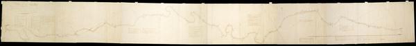
Cartographic A Plan of the River Schuylkill Wherein are laid down the several Shoals with the depth of Water on each in Inches, also the Depth of the Channel in general in the beginning of August 1773, Together with the means proposed for improving the Navigation of s Foxed, soiled, stained and creased. Mounted on cloth and cropped. In pencil on recto: "No 89". Includes index to 66 numbered features. Military topographic map. Covers the counties of Berks, Chester, Montgomery and Philadelphia, Pennsylvania, between Reading and Philadelphia. Shows river features and depths by soundings. Does not show landward features. Pen-and-ink, pencil on laid paper. Title proper and first statement of responsibility from map recto. Title number supplied by cataloger. View Item
Image Cartographic 7 Items A Plan of the River Schuylkill Wherein are laid down the several Shoals with the depth of Water on each in Inches, also the Depth of the Channel in general in the beginning of August 1773, Together with the means proposed for improving the Navigation of s Foxed, soiled, stained and creased. Mounted on cloth and cropped. In pencil on recto: "No 89". Includes index to 66 numbered features. Military topographic map. Covers the counties of Berks, Chester, Montgomery and Philadelphia, Pennsylvania, between Reading and Philadelphia. Shows river features and depths by soundings. Does not show landward features. Pen-and-ink, pencil on laid paper. Title proper and first statement of responsibility from map recto. Title number supplied by cataloger. View Item
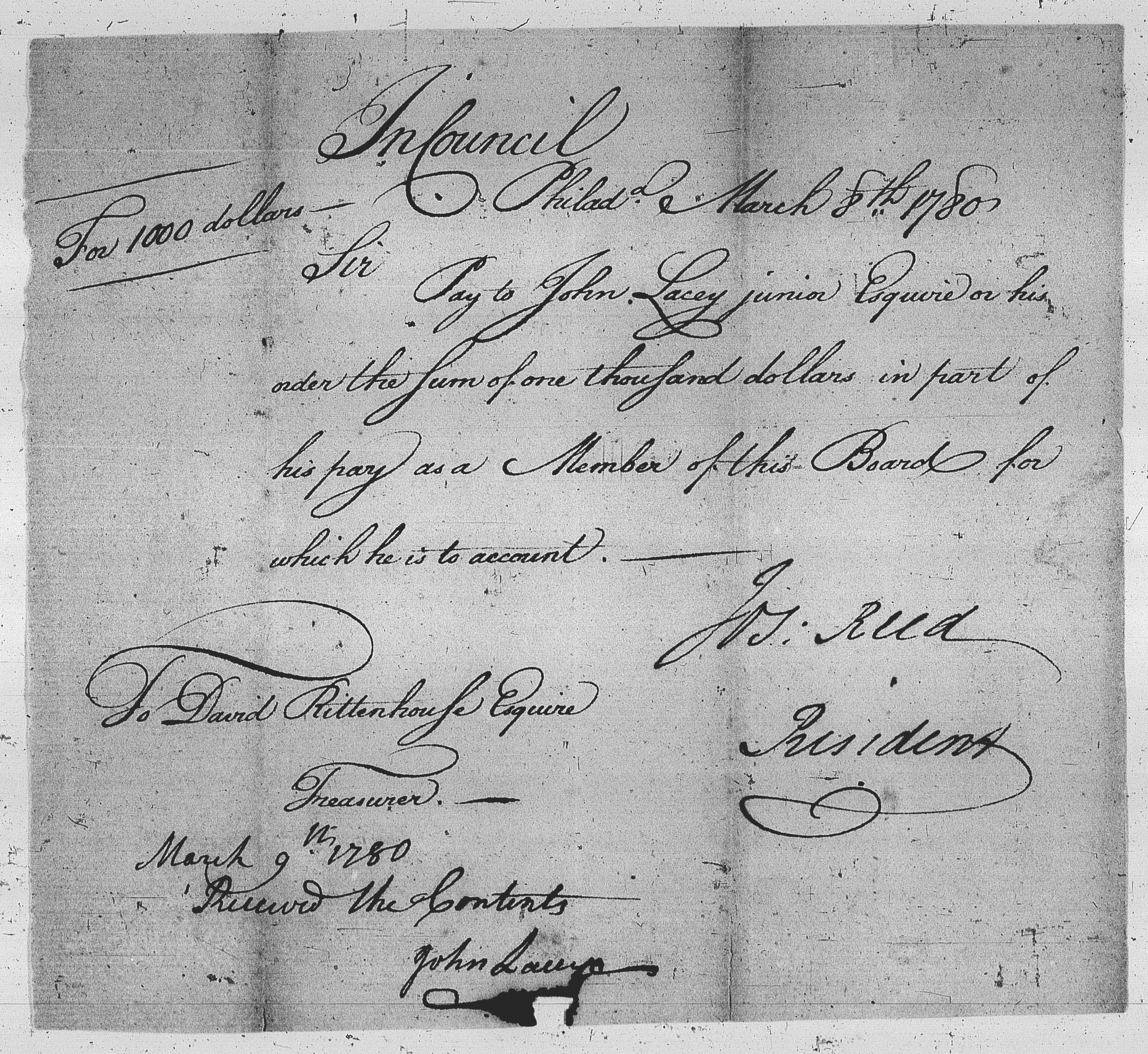
Image Text 2 Items Order to pay from Joseph Reed to David Rittenhouse, dated August 3, 1780. View Item
Cartographic [A Contraction of Do.] No. 89 B. / Copied from a Plan of Mr Rittenhouse's by Robt Erskine F.R.S. 1779 ; by Robert Erskine F.R.S. Geogr. A. U.S. and Assistants. Foxed- soiled- frayed. Sheathed in mylar. In ink on verso: "No. 89 B." In pencil on recto: "No 89 B". Military topographic map. Covers the counties of Chester- Montgomery and Delaware- Pennsylvania. Shows roads running through Norristown and Philadelphia. Also shows buildings and owners' names- landforms and streams. No title on recto or verso; title proper supplied by cataloger. Title number from map verso. First statement of responsibility from map recto. View Item
Cartographic A Plan of the River Schuylkill Wherein are laid down the several Shoals with the depth of Water on each in Inches also the Depth of the Channel in general in the beginning of August 1773 Together with the means proposed for improving the Navigation of s Foxed- soiled- stained and creased. Mounted on cloth and cropped. In pencil on recto: "No 89". Includes index to 66 numbered features. Military topographic map. Covers the counties of Berks- Chester- Montgomery and Philadelphia- Pennsylvania- between Reading and Philadelphia. Shows river features and depths by soundings. Does not show landward features. Pen-and-ink- pencil on laid paper. Title proper and first statement of responsibility from map recto. Title number supplied by cataloger. View Item
Image Collection 1180 Items Joseph Reed and Esther De Berdt Reed papers, 1757-1874 Joseph Reed (1741-1785) was a lawyer, Revolutionary War soldier, and statesman born in Trenton, New Jersey. His wife, Esther De Berdt (1747-1780), organized aid for the Continental Army during the Revolution and was born in London, England. View Collection