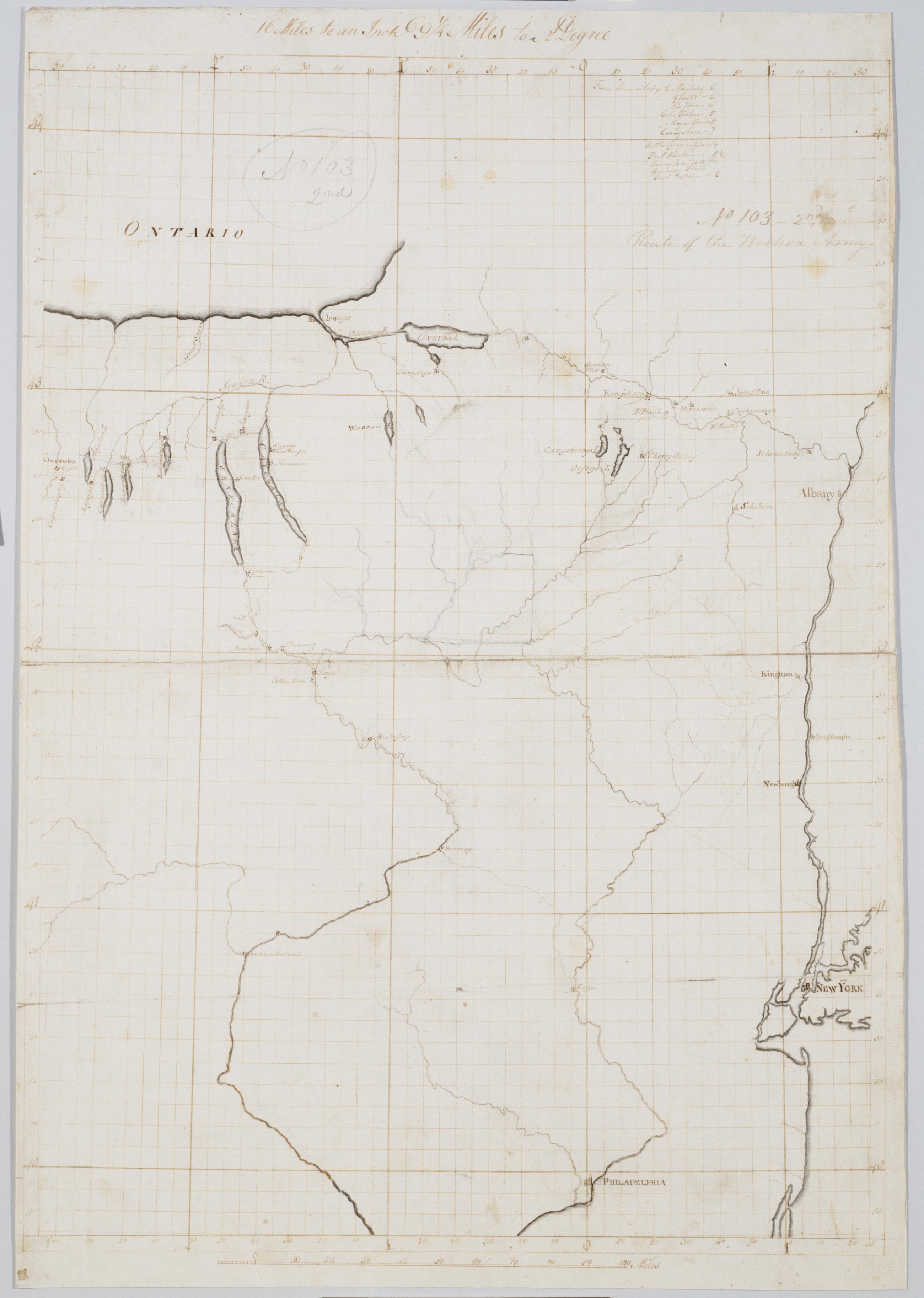
Cartographic Route of the Western Army. No 103-2nd [i.e., No. 101-4th] by R.E. ; by Robert Erskine F.R.S. Geogr. A. U.S. and Assistants. In pencil on recto: "No 103 2nd" and on verso "No: 103." Military topographical map. Covers parts of New York, Pennsylvania and New Jersey. Pen-and-ink, pencil on laid paper. Sheet carries no title on verso. Shows relief by hachures. Soiled, stained, creased and abraded. Mounted on cloth, bound and cropped, disbound and silked by subsequent owners. Cleaned after removal of backings 1999; some fill remains. Sheathed in mylar. Title proper from recto is the work of a later editor--Simeon DeWitt or his assign--subsequent to 1820. View Item
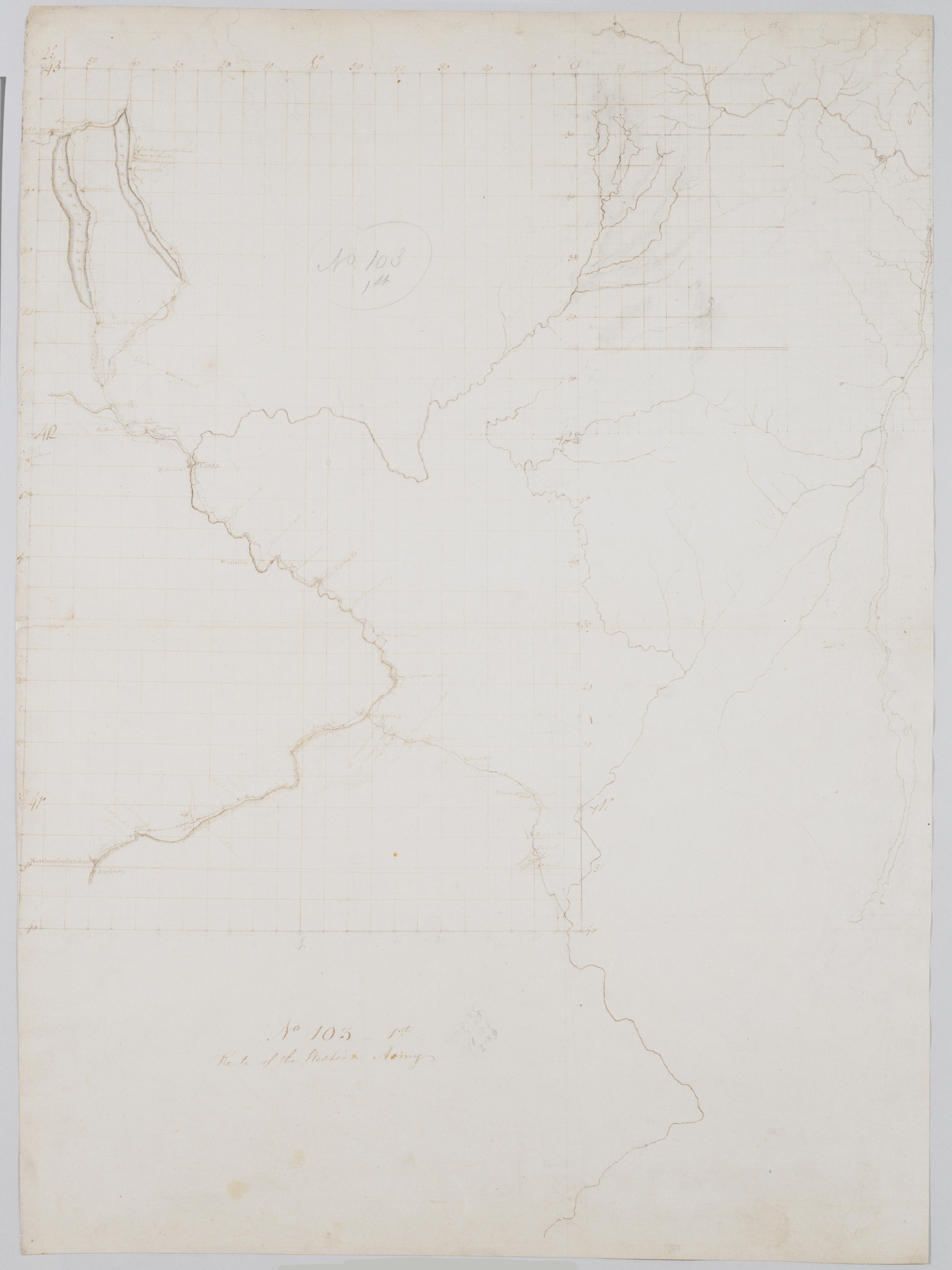
Cartographic Route of the Western Army. No 103-1st [i.e., No. 101-3rd] by R.E. ; by Robert Erskine F.R.S. Geogr. A. U.S. and Assistants. In pencil on recto: "No 103 1st" and on verso "No 103." Military topographical map. Covers parts of New York, Pennsylvania and New Jersey. Pen-and-ink, pencil on laid paper. Sheet carries no title on verso. Shows relief by hachures. Soiled, stained, creased and abraded. Mounted on cloth, bound and cropped, disbound and silked by subsequent owners. Cleaned after removal of backings 1999; some fill remains. Sheathed in mylar. Title proper from recto is the work of a later editor--Simeon DeWitt or his assign--subsequent to 1820. View Item
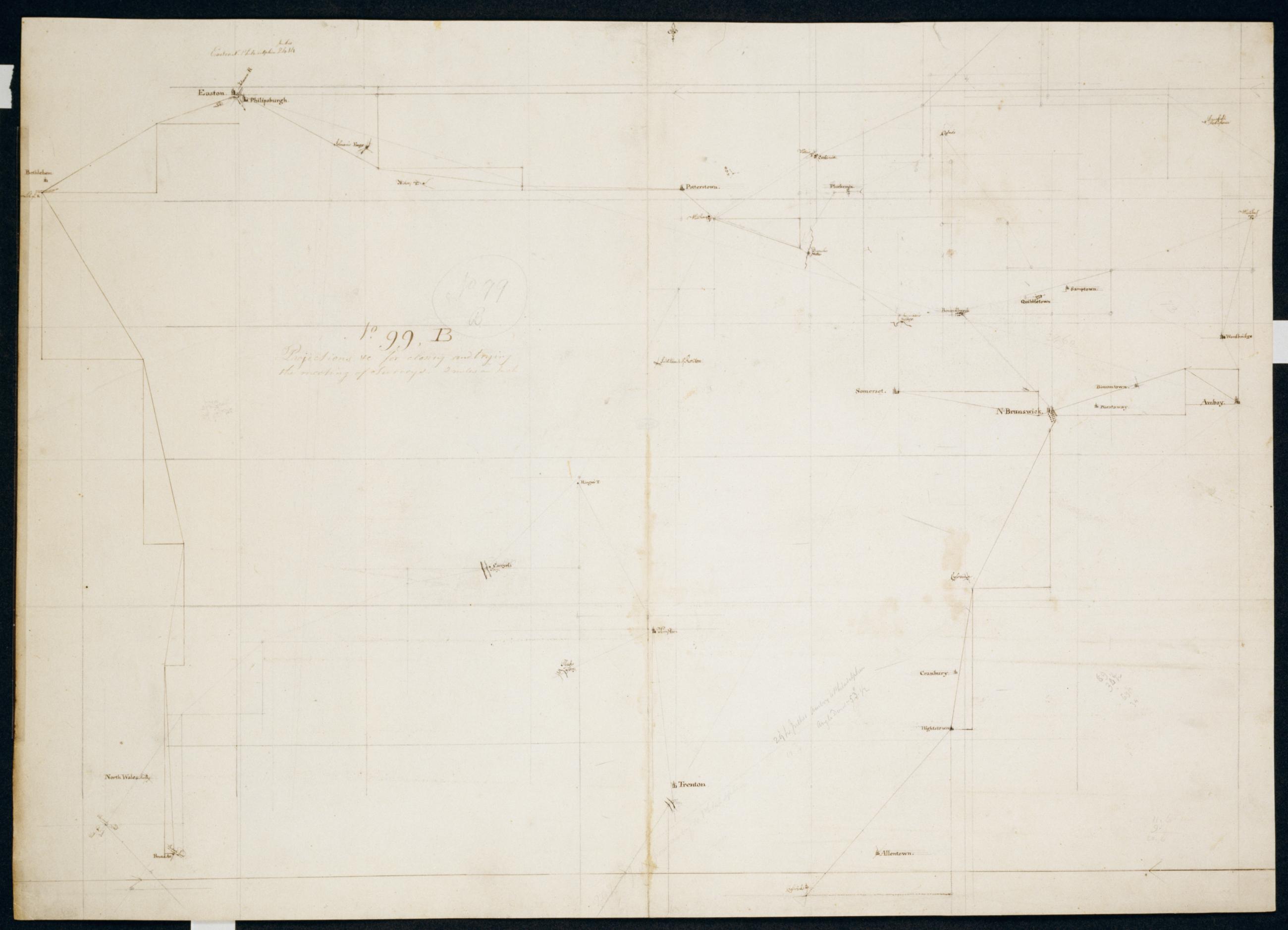
Cartographic Projections +c for closing and trying the meeting of Surveys. No. 99, B / Large paper by Capt. Scull ; by Robert Erskine F.R.S. Geogr. A. U.S. and Assistants. In ink on verso: "No. 99B". In pencil on recto: "No 99 B". Military topographic map; an early draft. Covers Warren County in New York; Hunterdon, Mercer, Middlesex, Monmouth, Somerset and Union counties in New Jersey; and Northampton, Bucks and Montgomery counties in Pennsylvania. Pen-and-ink, pencil on laid paper. Soiled, stained, creased, soiled and abraded. Mounted on cloth, bound and cropped, disbound and silked by subsequent owners. Cleaned after removal of backings 1999; some fill remains. Sheathed in mylar. View Item
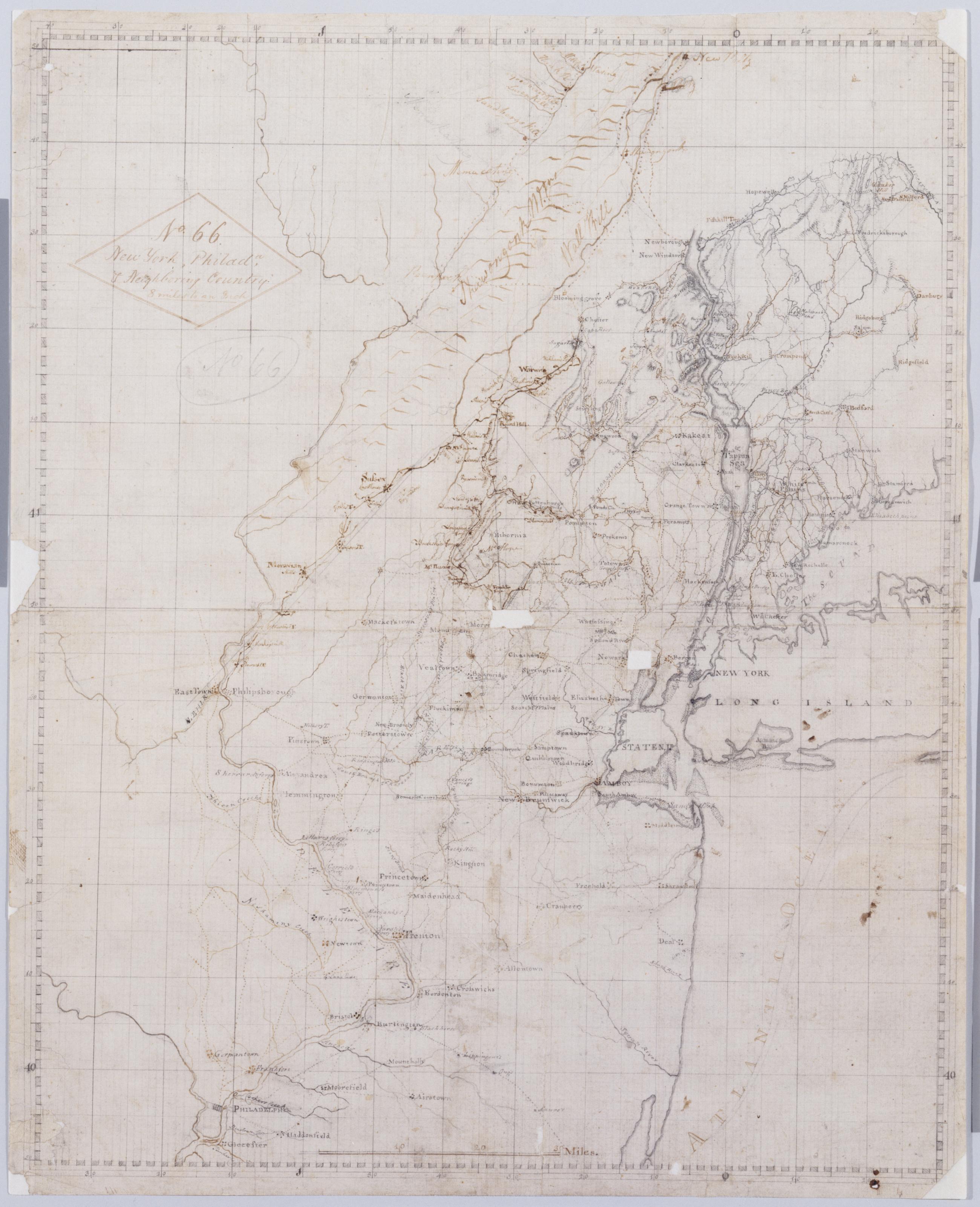
Cartographic New York, Philada, + Neighboring Country : 8 miles to an Inch. No. 66 / [fr.] S. Dewitt ; by Robert Erskine F.R.S. Geogr. A. U.S. and Assistants. Imperfect: lacking two 1 x 1 cm. patches near center of map. In ink on verso: "No. 66-". In pencil on recto: "No 66". Military topographic map. Covers northern New Jersey and adjacent parts of Pennsylvania, New York south of New Paltz, and western Connecticut. Shows roads, towns, streams. Pen-and-ink, grey wash, pencil on laid paper. Prime meridian New York (N.Y.). Shows some relief by hachures. Stained, creased, frayed and abraded. Mounted on cloth, bound and cropped, disbound and silked by subsequent owners. Cleaned after removal of backings 1999; some fill remains. Lined with China paper. View Item
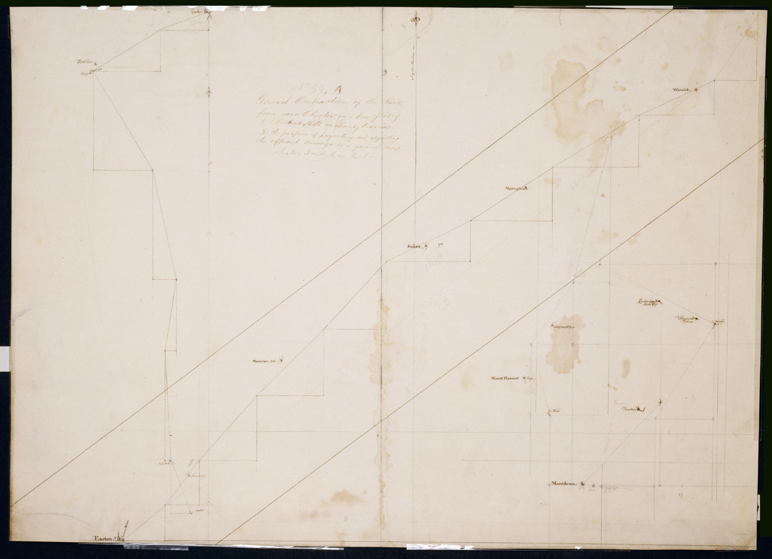
Cartographic General Contraction of the Road from near Chester in New Jersey to Chestnut Hill in Pennsylvania For the purpose of projecting and adjusting the different surveys in a general map. No 99, A / Large paper by Capt. Scull ; by Robert Erskine F.R.S. Geogr. A. In pencil on recto: "No 99 A". Military topographic map; an early draft. Lefthand segment joins center one at Easton; righthand segment continguous as drawn with center segment. Covers the counties of Northampton, Bucks and Montgomery in Pennsylvania and of Orange, Sussex, Warren, Morris and Passaic in New Jersey. Pen-and-ink, pencil on laid paper. Stained, soiled, creased, and abraded. Mounted on cloth, bound and cropped, disbound and silked by subsequent owners. Cleaned after removal of backings 1999; re-lined with China paper. Sheathed in mylar. View Item
Cartographic Route of the Western Army. No 103-2nd [i.e. No. 101-4th] by R.E. ; by Robert Erskine F.R.S. Geogr. A. U.S. and Assistants. In pencil on recto: "No 103 2nd" and on verso "No: 103." Military topographical map. Covers parts of New York- Pennsylvania and New Jersey. Pen-and-ink- pencil on laid paper. Sheet carries no title on verso. Shows relief by hachures. Soiled- stained- creased and abraded. Mounted on cloth- bound and cropped- disbound and silked by subsequent owners. Cleaned after removal of backings 1999; some fill remains. Sheathed in mylar. Title proper from recto is the work of a later editor--Simeon DeWitt or his assign--subsequent to 1820. View Item
Cartographic Route of the Western Army. No 103-1st [i.e. No. 101-3rd] by R.E. ; by Robert Erskine F.R.S. Geogr. A. U.S. and Assistants. In pencil on recto: "No 103 1st" and on verso "No 103." Military topographical map. Covers parts of New York- Pennsylvania and New Jersey. Pen-and-ink- pencil on laid paper. Sheet carries no title on verso. Shows relief by hachures. Soiled- stained- creased and abraded. Mounted on cloth- bound and cropped- disbound and silked by subsequent owners. Cleaned after removal of backings 1999; some fill remains. Sheathed in mylar. Title proper from recto is the work of a later editor--Simeon DeWitt or his assign--subsequent to 1820. View Item
Cartographic Projections +c for closing and trying the meeting of Surveys. No. 99 B / Large paper by Capt. Scull ; by Robert Erskine F.R.S. Geogr. A. U.S. and Assistants. In ink on verso: "No. 99B". In pencil on recto: "No 99 B". Military topographic map; an early draft. Covers Warren County in New York; Hunterdon- Mercer- Middlesex- Monmouth- Somerset and Union counties in New Jersey; and Northampton- Bucks and Montgomery counties in Pennsylvania. Pen-and-ink- pencil on laid paper. Soiled- stained- creased- soiled and abraded. Mounted on cloth- bound and cropped- disbound and silked by subsequent owners. Cleaned after removal of backings 1999; some fill remains. Sheathed in mylar. View Item
Cartographic New York Philada + Neighboring Country : 8 miles to an Inch. No. 66 / [fr.] S. Dewitt ; by Robert Erskine F.R.S. Geogr. A. U.S. and Assistants. Imperfect: lacking two 1 x 1 cm. patches near center of map. In ink on verso: "No. 66-". In pencil on recto: "No 66". Military topographic map. Covers northern New Jersey and adjacent parts of Pennsylvania- New York south of New Paltz- and western Connecticut. Shows roads- towns- streams. Pen-and-ink- grey wash- pencil on laid paper. Prime meridian New York (N.Y.). Shows some relief by hachures. Stained- creased- frayed and abraded. Mounted on cloth- bound and cropped- disbound and silked by subsequent owners. Cleaned after removal of backings 1999; some fill remains. Lined with China paper. View Item
Cartographic General Contraction of the Road from near Chester in New Jersey to Chestnut Hill in Pennsylvania For the purpose of projecting and adjusting the different surveys in a general map. No 99 A / Large paper by Capt. Scull ; by Robert Erskine F.R.S. Geogr. A. In pencil on recto: "No 99 A". Military topographic map; an early draft. Lefthand segment joins center one at Easton; righthand segment continguous as drawn with center segment. Covers the counties of Northampton- Bucks and Montgomery in Pennsylvania and of Orange- Sussex- Warren- Morris and Passaic in New Jersey. Pen-and-ink- pencil on laid paper. Stained- soiled- creased- and abraded. Mounted on cloth- bound and cropped- disbound and silked by subsequent owners. Cleaned after removal of backings 1999; re-lined with China paper. Sheathed in mylar. View Item