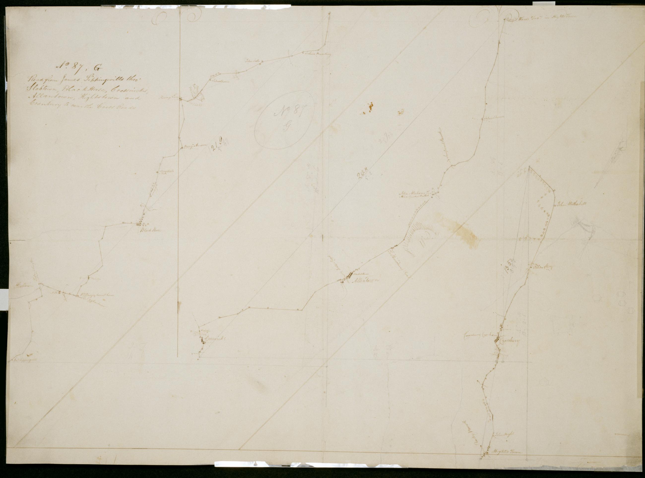
Cartographic Road from James Sippingwills thro' Slabtown, Black Horse, Crosswicks, Allantown, Hightstown and Cranbury to near the Cross Roads. No. 87, G / by Robert Erskine F.R.S. Geogr. A. U.S. and Assistants. In pencil on recto: "No 87 G". Military topographic map in 3 segments; those to right of sheet fit north of the leftmost. Map covers the townships of Chesterfield, Mansfield, Springfield, Easthampton and Hamilton in Burlington County, East Windsor and Washington in Mercer County, and Upper Freehold in Monmouth County, New Jersey. Shows roads running through Mount Holly, Jacksonville, Columbus, Mansfield and Mansfield Square; Crosswicks, Allentown, New Canton and New Sharon; Hightstown and Cranbury. Also shows buildings and owners' names, landforms and streams. View Item
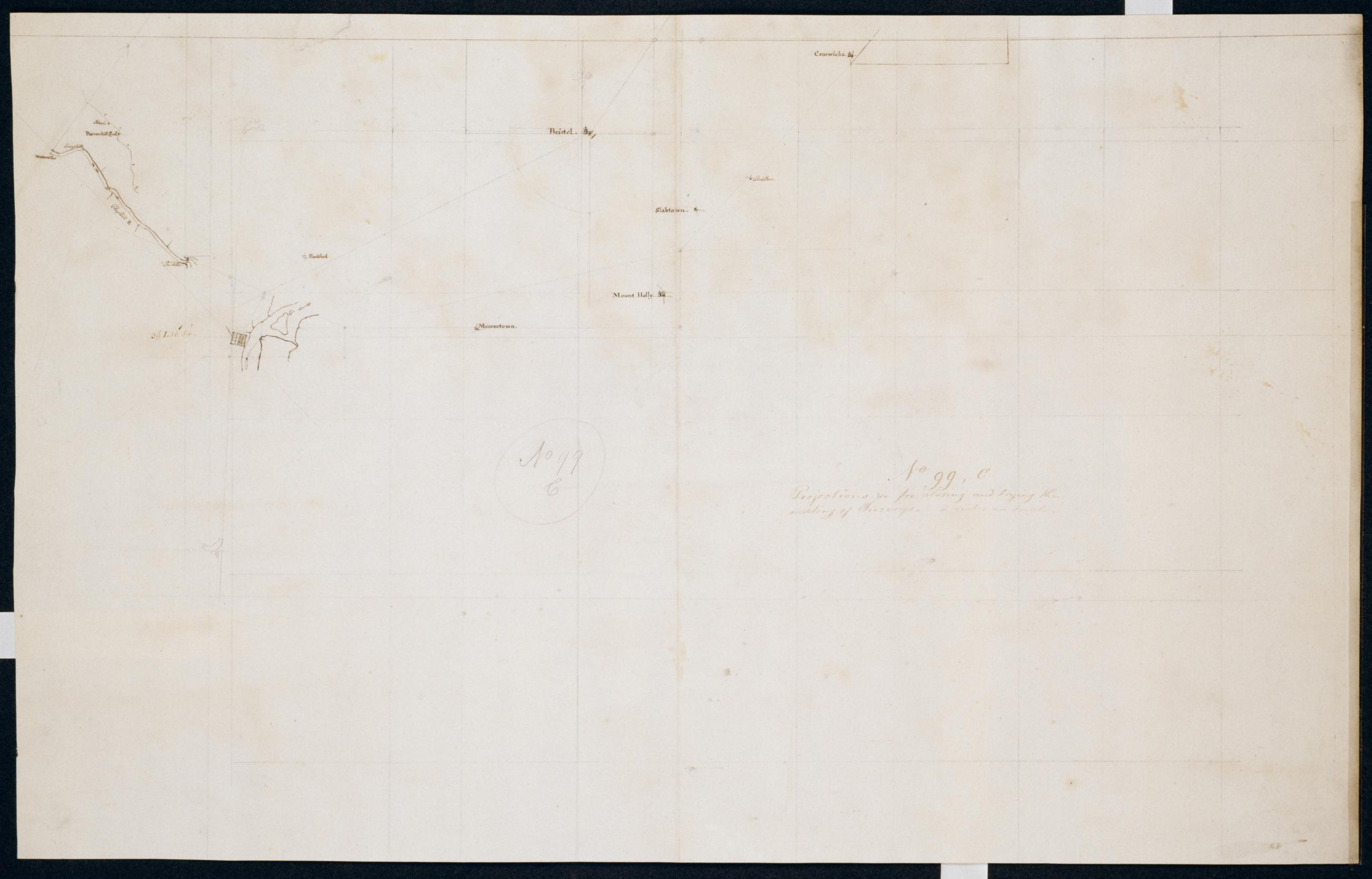
Cartographic Projections +c for closing and trying the meeting of Surveys. No. 99, C / Large paper by Capt. Scull ; by Robert Erskine F.R.S. Geogr. A. U.S. and Assistants. In ink on verso: "No. 99 C". In pencil on recto: "No 99 C". Military topographic map; an early draft. Covers Mercer, Burlington and Camden counties in New Jersey, Montgomery County and Philadelphia in Pennsylvania. Pen-and-ink, pencil on laid paper. Soiled, stained, creased and abraded. Mounted on cloth, bound and cropped, disbound and silked by subsequent owners. Cleaned after removal of backings 1999; some fill remains. Sheathed in mylar. Title proper from recto is the work of a later editor--Simeon DeWitt or his assign--subsequent to 1820. View Item
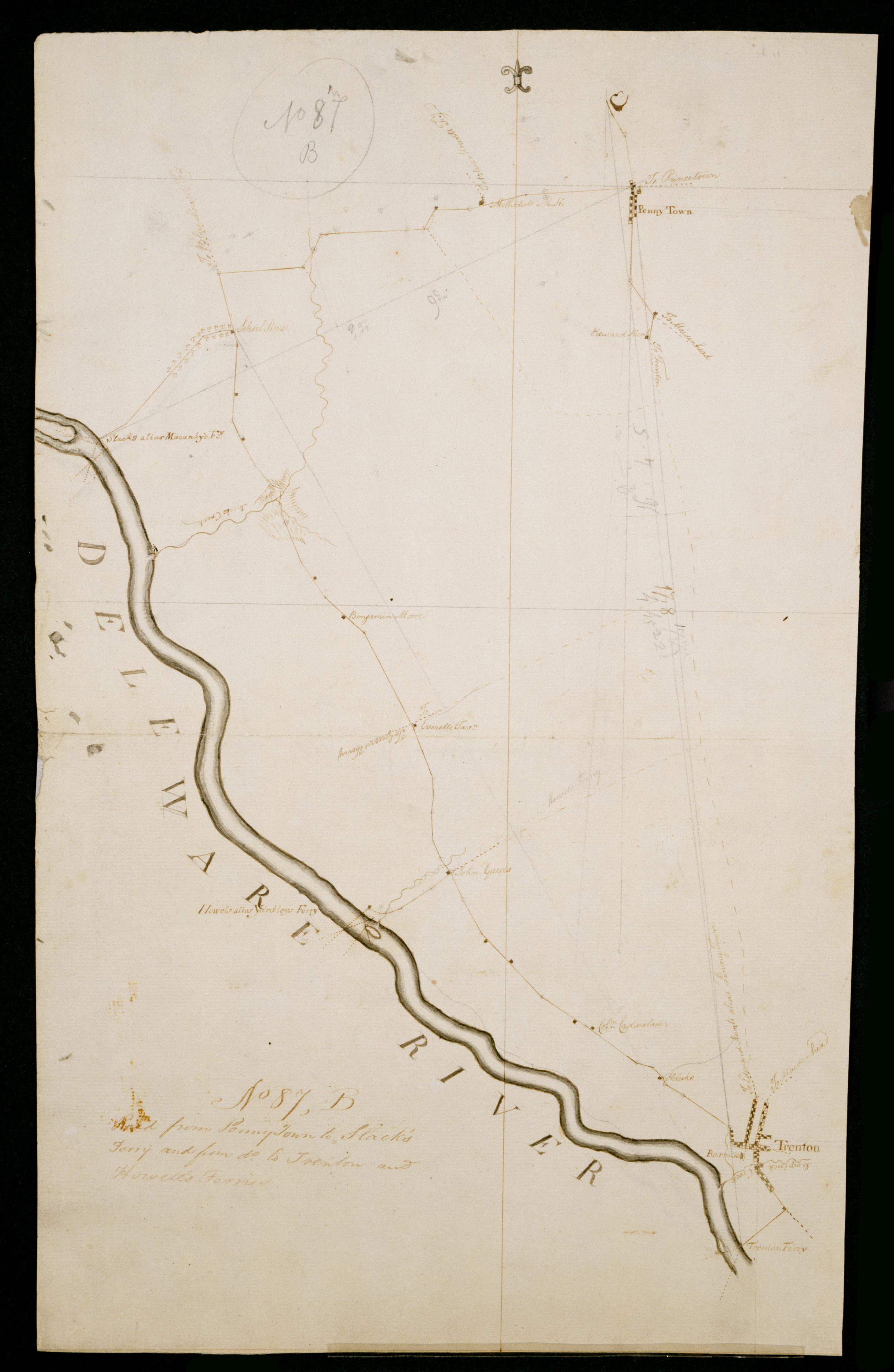
Cartographic Road from Penny Town to Slack's Ferry and from do. to Trenton and Howell's Ferries. No 87, B / by Robert Erskine F.R.S. Geogr. A. U.S. and Assistants. In ink on verso: "... Howells Ferries No. 87-B" First part of text lost to cropping. In pencil on recto: "No 87 B". Military topographic map. Covers the townships of Ewing and Hopewell in Mercer County, New Jersey. Shows roads running through Pennington, Bear Tavern and Trenton. Also shows buildings and owners' names, landforms and streams. Pen-and-ink, pencil on laid paper. Shows relief by hachures. Soiled, stained, creased, frayed and abraded. Mounted on cloth, bound and cropped, disbound and silked by subsequent owners. Cleaned after removal of backings 1999; some fill remains. View Item
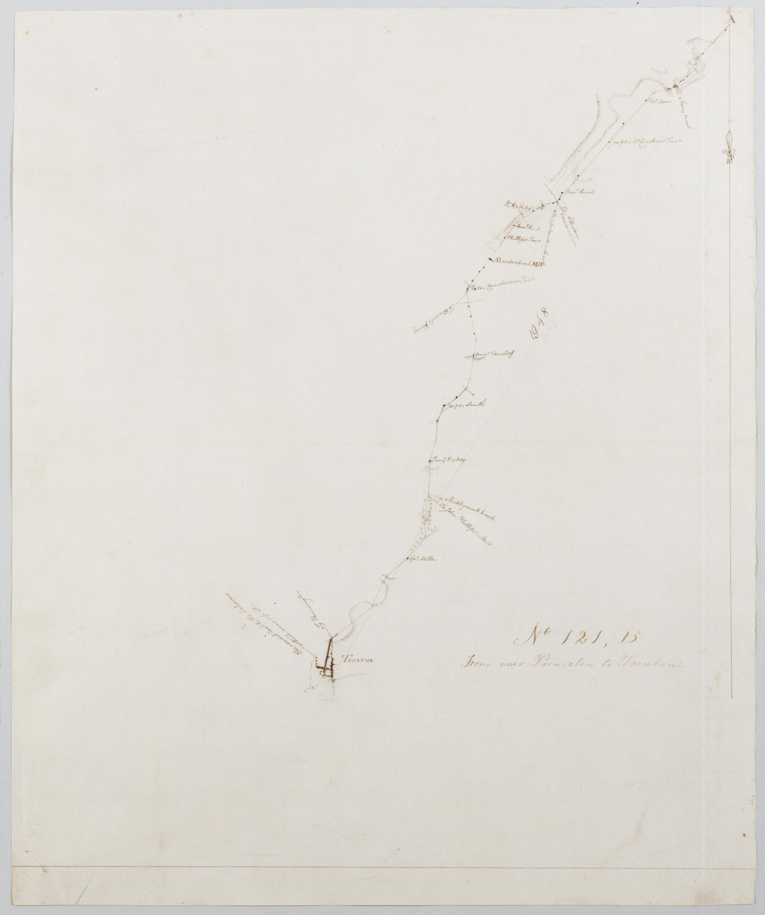
Cartographic From near Princeton to Trenton. No 121, B / by Robert Erskine F.R.S. Geogr. A. U.S. and Assistants. Military topographic map. Covers the township of Lawrence in Mercer County, New Jersey. Shows roads running through Princeton, Lawrenceville and Trenton. Also shows buildings and owners' names, landforms and streams. Pen-and-ink, pencil on laid paper. Shows relief by hachures. Soiled, creased and abraded. Mounted on cloth, bound and cropped, disbound and silked by subsequent owners. Cleaned after removal of backings 1999; some fill remains. Sheathed in mylar. Title proper from recto is the work of a later editor--Simeon DeWitt or his assign--subsequent to 1820. View Item
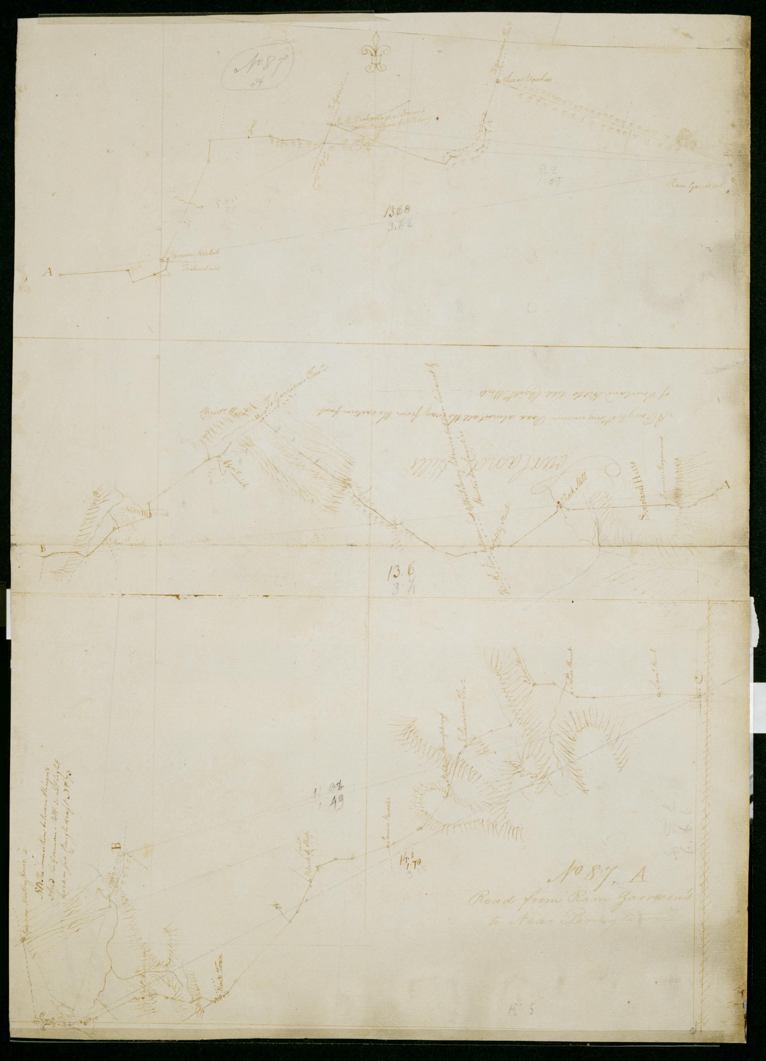
Cartographic Road from Ram Garrison's to Near Penny town. No 87, A / by Robert Erskine F.R.S. Geogr. A. U.S. and Assistants. In pencil on recto: "No 87 A". Military topographic map in three segments meant to be joined at points marked "A" and "B." Top and middle segments oriented with north to top of sheet; bottom segment oriented with north to left of sheet. Map covers the townships of Hillsboro and Montgomery in Somerset County, East Amwell and West Amwell in Hunterdon County and Hopewell in Mercer County, New Jersey. View Item
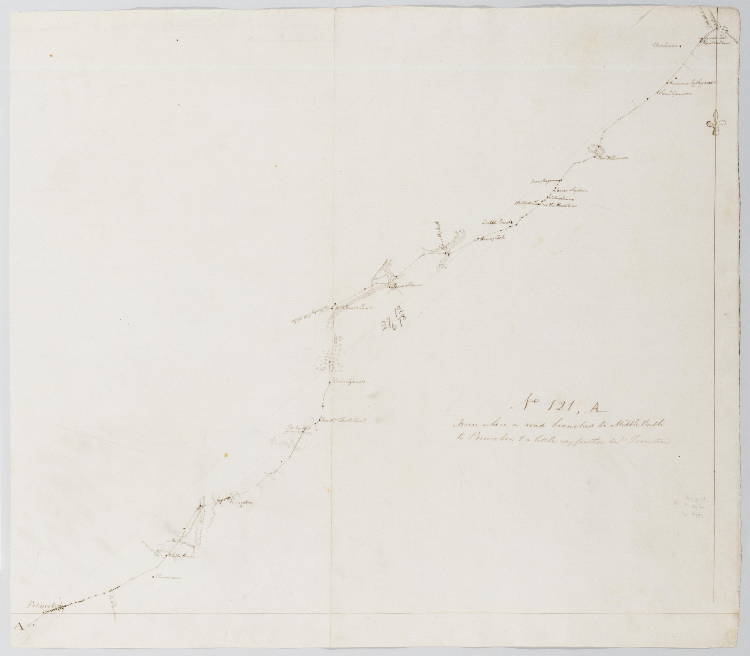
Cartographic From where a road branches to Middle Bush to Princeton + a little way farther towds Trenton. No 121, A / by Robert Erskine F.R.S. Geogr. A. U.S. and Assistants. Military topographic map. Covers the townships of Princeton in Mercer County, Franklin in Somerset County and South Brunswick in Middlesex County, New Jersey. Shows roads running through Princeton, Kingston, Tenmile Run and Franklin Park. Also shows buildings and owners' names, landforms and streams. Pen-and-ink, pencil on laid paper. Shows relief by hachures. Stained, soiled, creased and abraded. Mounted on cloth, bound and cropped, disbound and silked by subsequent owners. Cleaned after removal of backings 1999; some fill remains. Sheathed in mylar. View Item
Cartographic Road from James Sippingwills thro' Slabtown Black Horse Crosswicks Allantown Hightstown and Cranbury to near the Cross Roads. No. 87 G / by Robert Erskine F.R.S. Geogr. A. U.S. and Assistants. In pencil on recto: "No 87 G". Military topographic map in 3 segments; those to right of sheet fit north of the leftmost. Map covers the townships of Chesterfield- Mansfield- Springfield- Easthampton and Hamilton in Burlington County- East Windsor and Washington in Mercer County- and Upper Freehold in Monmouth County- New Jersey. Shows roads running through Mount Holly- Jacksonville- Columbus- Mansfield and Mansfield Square; Crosswicks- Allentown- New Canton and New Sharon; Hightstown and Cranbury. Also shows buildings and owners' names- landforms and streams. View Item
Cartographic Projections +c for closing and trying the meeting of Surveys. No. 99 C / Large paper by Capt. Scull ; by Robert Erskine F.R.S. Geogr. A. U.S. and Assistants. In ink on verso: "No. 99 C". In pencil on recto: "No 99 C". Military topographic map; an early draft. Covers Mercer- Burlington and Camden counties in New Jersey- Montgomery County and Philadelphia in Pennsylvania. Pen-and-ink- pencil on laid paper. Soiled- stained- creased and abraded. Mounted on cloth- bound and cropped- disbound and silked by subsequent owners. Cleaned after removal of backings 1999; some fill remains. Sheathed in mylar. Title proper from recto is the work of a later editor--Simeon DeWitt or his assign--subsequent to 1820. View Item
Cartographic Road from Penny Town to Slack's Ferry and from do. to Trenton and Howell's Ferries. No 87 B / by Robert Erskine F.R.S. Geogr. A. U.S. and Assistants. In ink on verso: "... Howells Ferries No. 87-B" First part of text lost to cropping. In pencil on recto: "No 87 B". Military topographic map. Covers the townships of Ewing and Hopewell in Mercer County- New Jersey. Shows roads running through Pennington- Bear Tavern and Trenton. Also shows buildings and owners' names- landforms and streams. Pen-and-ink- pencil on laid paper. Shows relief by hachures. Soiled- stained- creased- frayed and abraded. Mounted on cloth- bound and cropped- disbound and silked by subsequent owners. Cleaned after removal of backings 1999; some fill remains. View Item
Cartographic From near Princeton to Trenton. No 121 B / by Robert Erskine F.R.S. Geogr. A. U.S. and Assistants. Military topographic map. Covers the township of Lawrence in Mercer County- New Jersey. Shows roads running through Princeton- Lawrenceville and Trenton. Also shows buildings and owners' names- landforms and streams. Pen-and-ink- pencil on laid paper. Shows relief by hachures. Soiled- creased and abraded. Mounted on cloth- bound and cropped- disbound and silked by subsequent owners. Cleaned after removal of backings 1999; some fill remains. Sheathed in mylar. Title proper from recto is the work of a later editor--Simeon DeWitt or his assign--subsequent to 1820. View Item
Cartographic Road from Ram Garrison's to Near Penny town. No 87 A / by Robert Erskine F.R.S. Geogr. A. U.S. and Assistants. In pencil on recto: "No 87 A". Military topographic map in three segments meant to be joined at points marked "A" and "B." Top and middle segments oriented with north to top of sheet; bottom segment oriented with north to left of sheet. Map covers the townships of Hillsboro and Montgomery in Somerset County- East Amwell and West Amwell in Hunterdon County and Hopewell in Mercer County- New Jersey. View Item
Cartographic From where a road branches to Middle Bush to Princeton + a little way farther towds Trenton. No 121 A / by Robert Erskine F.R.S. Geogr. A. U.S. and Assistants. Military topographic map. Covers the townships of Princeton in Mercer County- Franklin in Somerset County and South Brunswick in Middlesex County- New Jersey. Shows roads running through Princeton- Kingston- Tenmile Run and Franklin Park. Also shows buildings and owners' names- landforms and streams. Pen-and-ink- pencil on laid paper. Shows relief by hachures. Stained- soiled- creased and abraded. Mounted on cloth- bound and cropped- disbound and silked by subsequent owners. Cleaned after removal of backings 1999; some fill remains. Sheathed in mylar. View Item