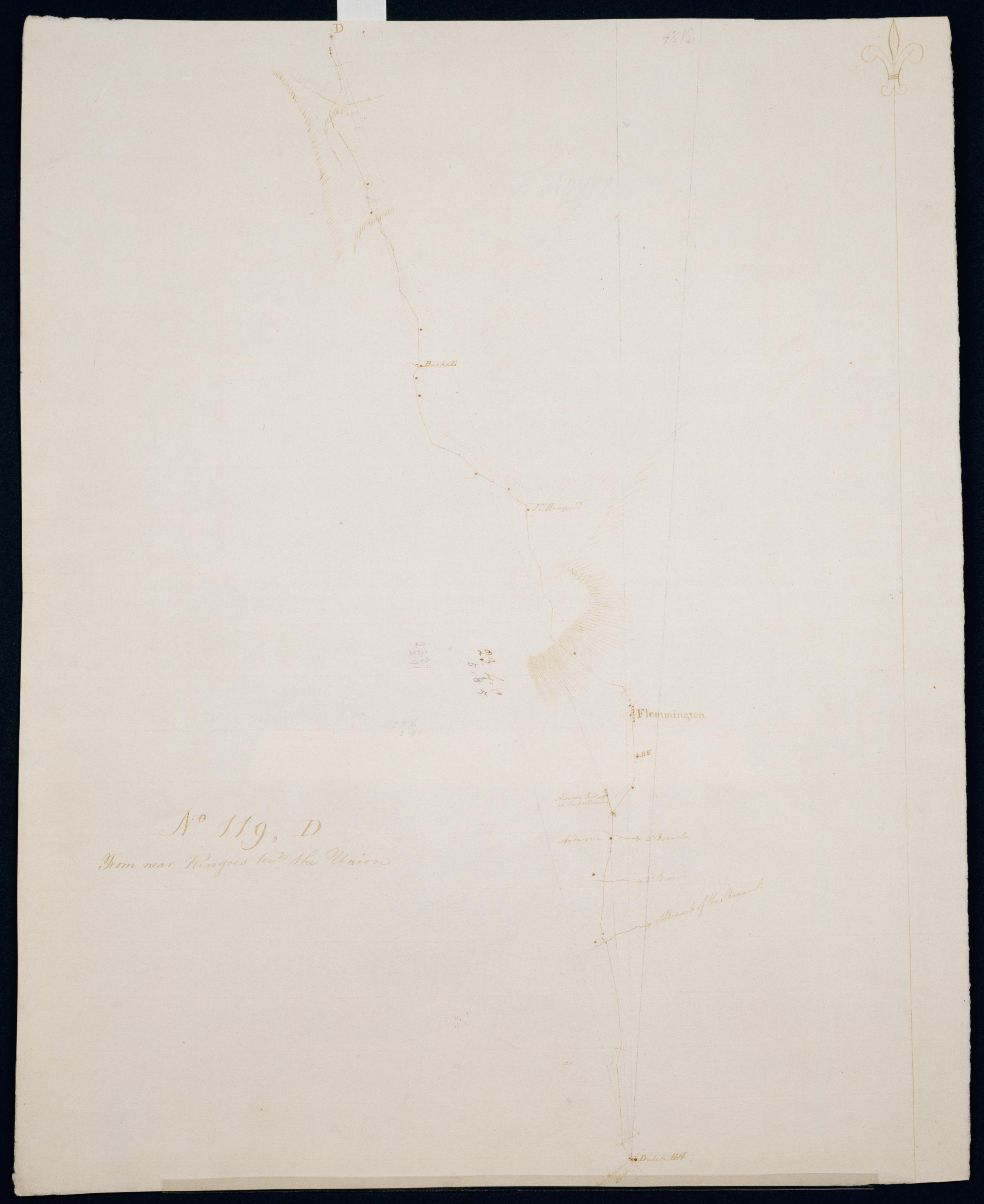
Cartographic From near Ringoes towds the Union. No 119, D / S DeWitt Geographer to the Army of the United States ; by Robert Erskine F.R.S. Geogr. A. U.S. and Assistants. Date of 1780 or 1781 based on verso text to sheet 119,F of series. First statement of responsibility from verso text on sheet 119,F of series. Military topographic map. Covers the townships of Raritan and Franklin in Hunterdon County, New Jersey. Shows roads running through Clinton, Sidney, Cherryville, Klinesville, Flemington, Copper Hill, Muirhead and Larison Corner. Also shows buildings and owners' names, landforms and streams. Pen-and-ink, pencil on laid paper. Shows relief by hachures. Stained, soiled , creased and abraded. View Item
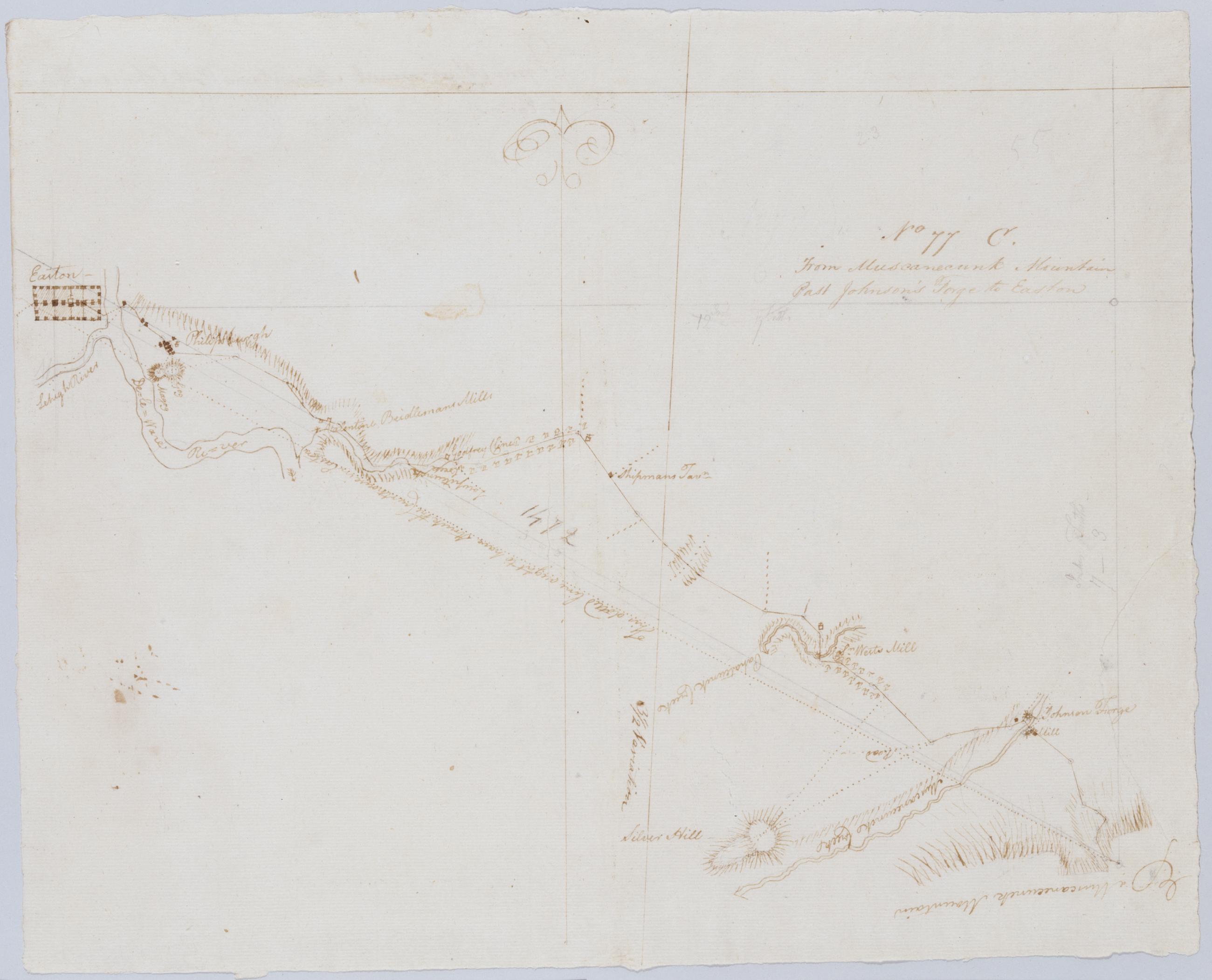
Cartographic From Muscanecunk Mountain Past Johnson's Forge to Easton. No 77 C / by Robert Erskine F.R.S. Geogr. A. U.S. and Assistants. In erased pencil on recto: "No 77 C". Military topographic map. Covers the townships of Greenwich and Pohatcong in Warren County and of Bethlehem in Hunterdon County, New Jersey; also covers part of Berks County, Pennsylvania. Shows roads running through Bloomsbury, Kennedy Mills, Still Valley and Phillipsburg in New Jersey as well as Easton, Pennsylvania. Also shows buildings and owners' names, landforms and streams. Pen-and-ink, pencil on laid paper. Shows relief by hachures. Title proper from recto is the work of a later editor--Simeon DeWitt or his assign--subsequent to 1820. View Item
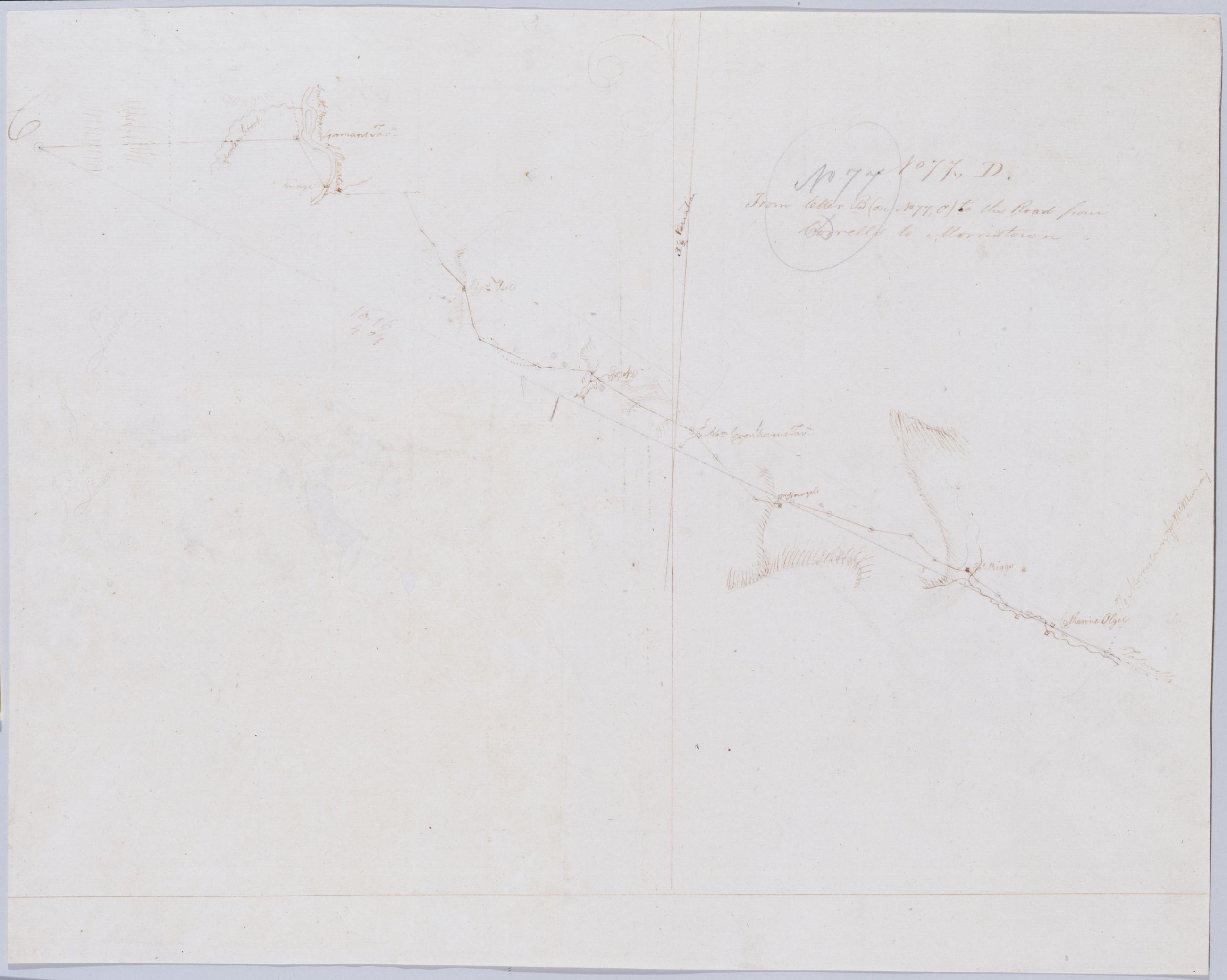
Cartographic From letter B (on No 77, C) to the Road from Corrells to Morristown. No 77, D / by Robert Erskine F.R.S. Geogr. A. U.S. and Assistants. In erased pencil on recto: "No 77 C". Military topographic map. Covers the townships of Franklin and Readington in Hunterdon County, New Jersey. Shows roads running through Lansdowne, Hamden, Sunnyside, Stanton and Pleasant Run. Also shows buildings and owners' names, landforms and streams. Notice that the verso title's "Letter B of the same number" properly refers to sheet 77,B not to any mark on sheet 77,C. Pen-and-ink, pencil on laid paper. Shows relief by hachures. Title proper from recto is the work of a later editor--Simeon DeWitt or his assign--subsequent to 1820. View Item
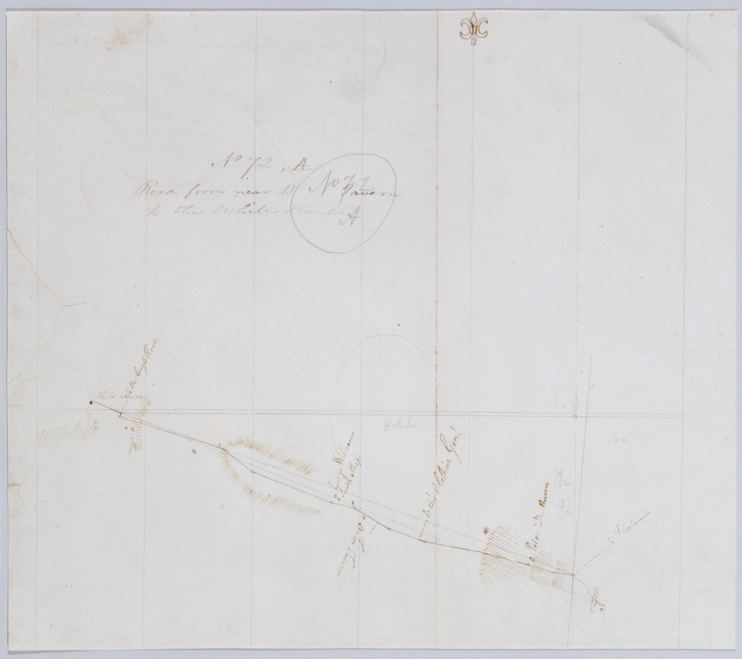
Cartographic Road from near B Tavern to the White House. No 72, A / by Robert Erskine F.R.S. Geogr. A. U.S. and Assistants. Foxed, creased, cracked and abraded. Mounted on cloth, bound and cropped, disbound and silked by subsequent owners. Cleaned after removal of backings 1999; some fill remains. Sheathed in mylar. In pencil on recto: "No 72 A". Military topographic map. Covers the townships of Branchburg and Readington in Hunterdon County, New Jersey. Shows roads running through White House and North Branch. Also shows buildings and owners' names, landforms and streams. Pen-and-ink, pencil on laid paper. Shows relief by hachures. View Item
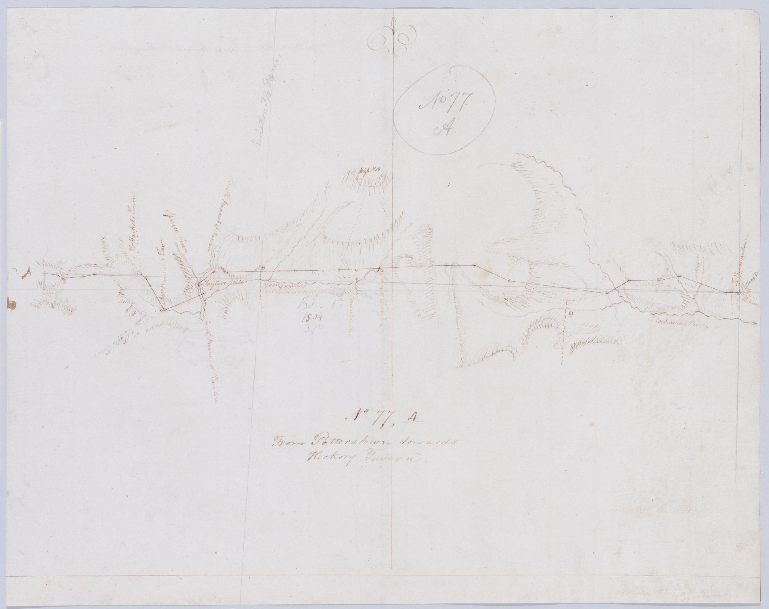
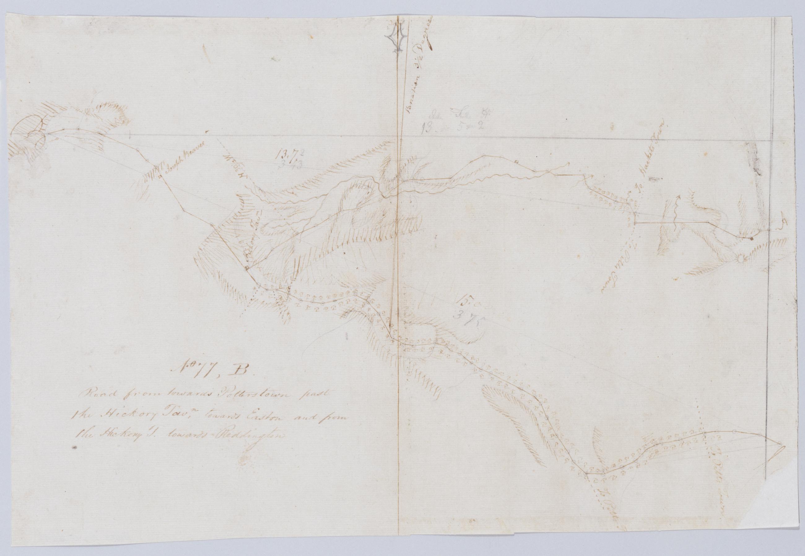
Cartographic Road from towards [sic] Potterstown past the Hickory Tavn, towards Easton and from the Hickory T. toward Reddington No 77, B / by Robert Erskine F.R.S. Geogr. A. U.S. and Assistants. Military topographic map. Covers the townships of Union, Bethlehem and Alexandria in Hunterdon County, New Jersey. Shows roads running through Perryville, The Hickory, Swinesburg, Mechling Corner and Mt. Salem. Also shows buildings and owners' names, landforms and streams. Pen-and-ink, pencil on laid paper. Shows relief by hachures. Soiled, foxed, and abraded. Mounted on cloth, bound and cropped, disbound and silked by subsequent owners. Cleaned after removal of backings 1999; some fill remains. Sheathed in mylar. View Item
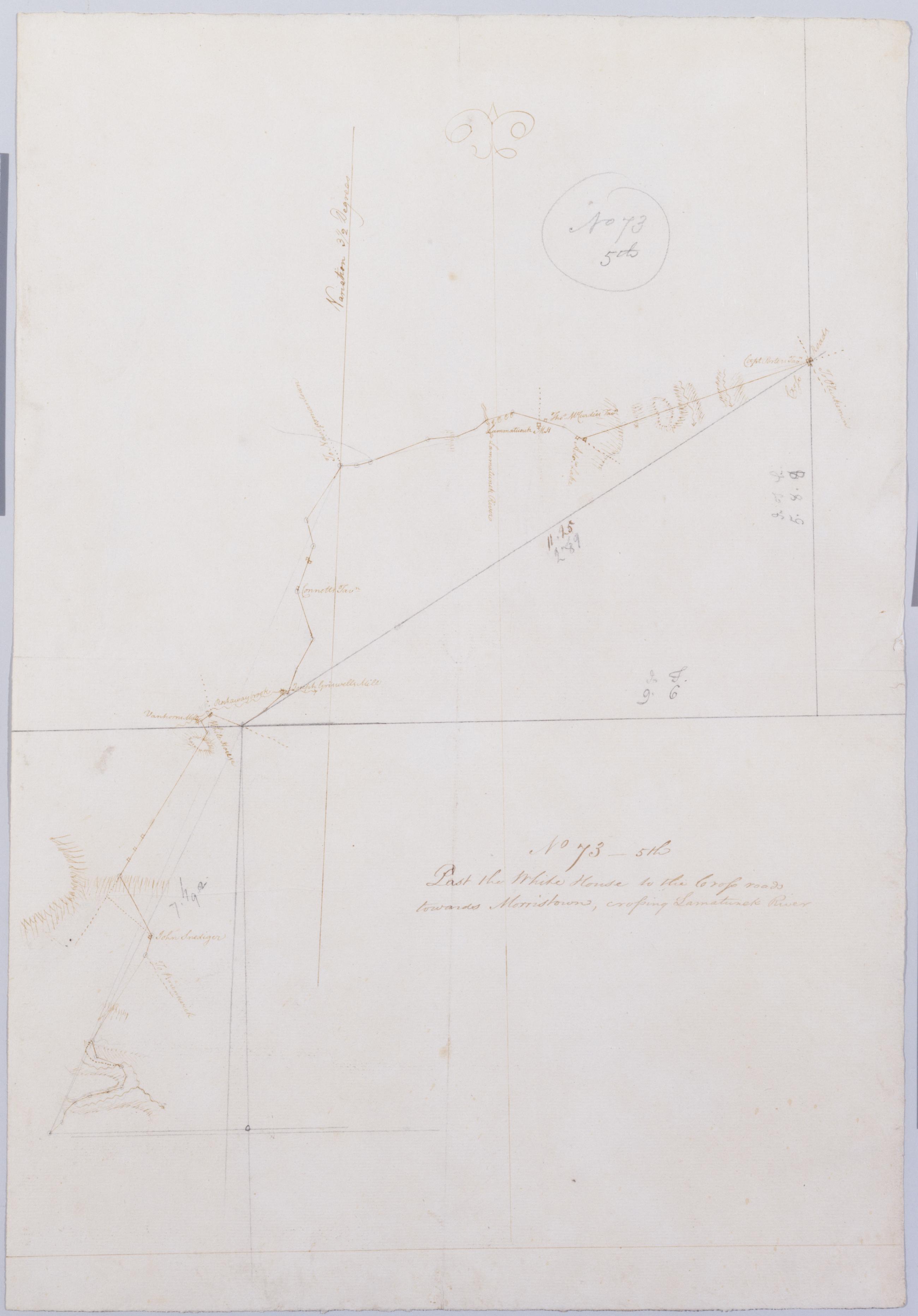
Cartographic Past the White House to the Cross roads towards Morristown, crossing Lamatunck River. No 73 - 5th / by Robert Erskine F.R.S. Geogr. A. U.S. and Assistants. Foxed, creased and abraded. Mounted on cloth, bound and cropped, disbound and silked by subsequent owners. Cleaned after removal of backings 1999; some fill remains. Sheathed in mylar. In pencil on recto: "No 73 5th". Military topographic map. Covers the townships of Bedminster in Somerset County and of Readington and Tewksbury in Hunterdon County, New Jersey. Shows roads running through White House, Lamington and Greater Crossroads. Also shows buildings and owners' names, landforms and streams. Pen-and-ink, pencil on laid paper. Shows relief by hachures. View Item
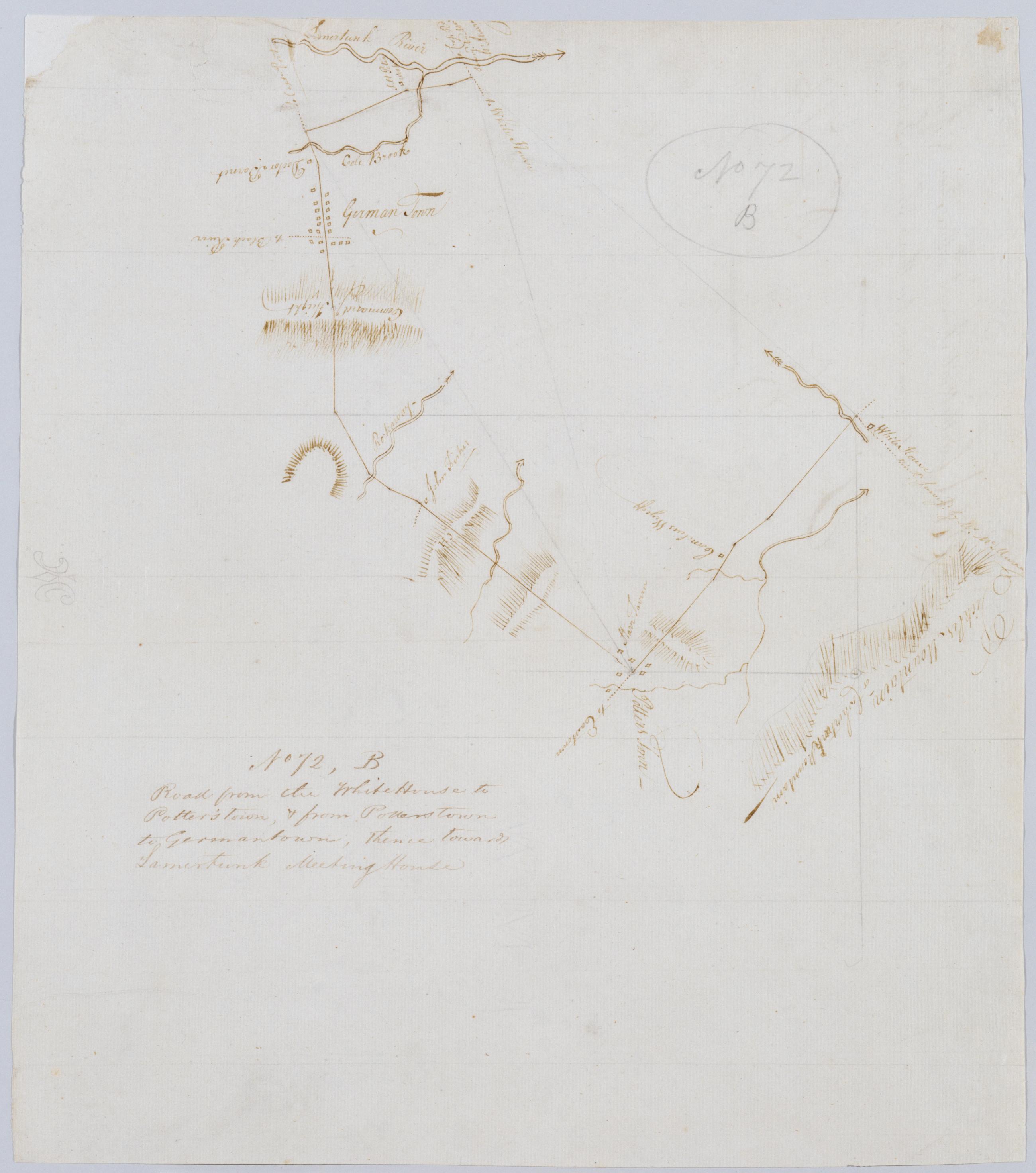
Cartographic Road from the White House to Potter's town, + from Potterstown to Germantown, thence towards Lamertunk Meeting House. No 72, B / by Robert Erskine F.R.S. Geogr. A. U.S. and Assistants. Foxed, creased, cracked and abraded. Mounted on cloth, bound and cropped, disbound and silked by subsequent owners. Cleaned after removal of backings 1999; some fill remains. Sheathed in mylar. In pencil on recto: "No 72 B". Military topographic map. Covers the townships of Tewksbury and Readington in Hunterdon County, New Jersey. Shows roads running through New Germantown, Potterstown and White House. Also shows buildings and owners' names, landforms and streams. Oriented with north to left of sheet. Pen-and-ink, pencil on laid paper. Shows relief by hachures. View Item
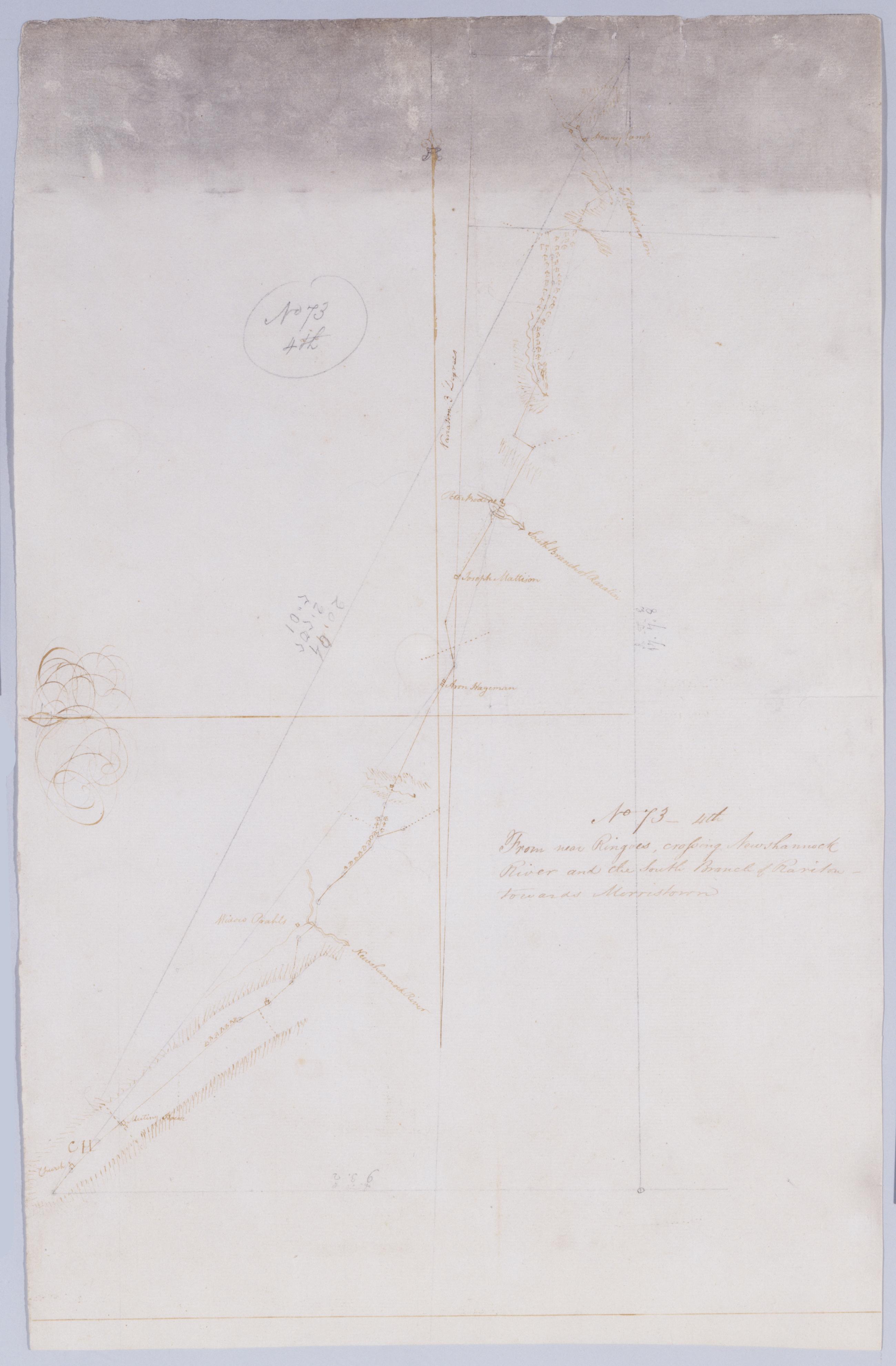
Cartographic From near Ringoes, crossing Newshannock River and the South Branch of Rariton - towards Morristown. No 73 - 4th / by Robert Erskine F.R.S. Geogr. A. U.S. and Assistants. Heavily soiled, frayed, creased and abraded. Mounted on cloth, bound and cropped, disbound and silked by subsequent owners. Cleaned after removal of backings 1999; some fill remains. Sheathed in mylar. In pencil on recto: "No 73 4th". Military topographic map. Covers the townships of East Amwell, Raritan and Readington in Hunterdon County, New Jersey. Shows roads running through Larison Corner, Reaville, Three Bridges and Pleasant Run. Also shows buildings and owners' names, landforms and streams. Pen-and-ink, pencil on laid paper. Shows relief by hachures. View Item
Cartographic Past the Union to Lewis's Tavern. No 119, E / S DeWitt Geographer to the Army of the United States ; by Robert Erskine F.R.S. Geogr. A. U.S. and Assistants. Date of 1780 or 1781 based on verso text to sheet 119,F of series. First statement of responsibility from verso text on sheet 119,F of series. In erased pencil on recto: "No 119 E". Military topographic map. Covers the townships of Bethlehem, Union and Franklin in Hunterdon County, New Jersey. Shows roads running through Polktown and Clinton. Also shows buildings and owners' names, landforms and streams. Pen-and-ink, pencil on laid paper. Shows relief by hachures. Stained, soiled , creased and abraded. Mounted on cloth, bound and cropped, disbound and silked by subsequent owners. View Item
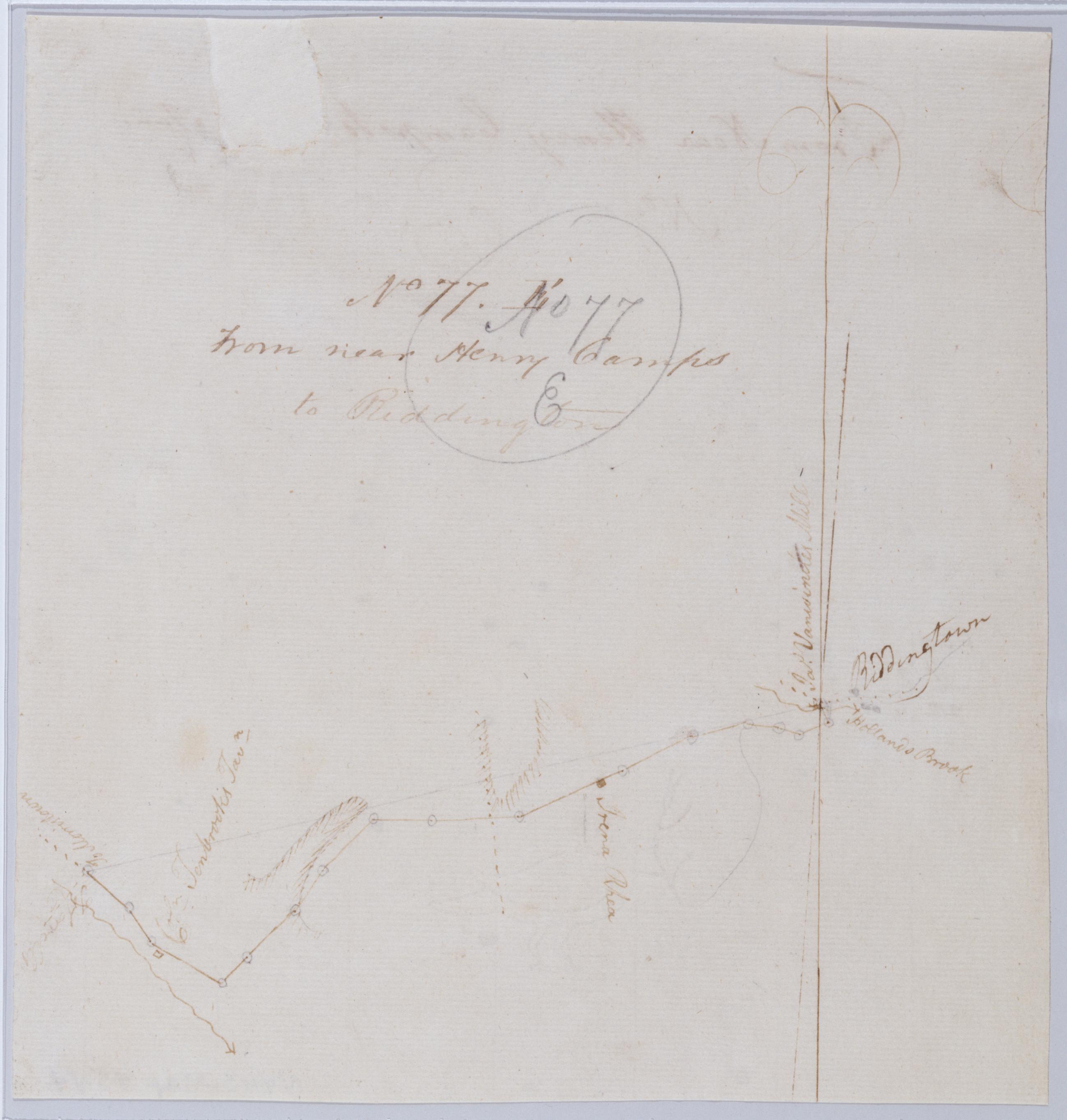
Cartographic From near Henry Camps to Reddington. No 77. E / by Robert Erskine F.R.S. Geogr. A. U.S. and Assistants. Frayed and abraded. Mounted on cloth, cropped and bound, disbound and silked by subsequent owners. Cleaned after removal of backings 1999; some fill remains. Sheathed in mylar. In pencil on recto: "No 77 E". Military topographic map. Covers Readington Township in Hunterdon County, New Jersey. Shows roads running through Pleasant Run and Readington. Also shows buildings and owners' names, landforms and streams. Pen-and-ink, pencil on laid paper. Shows relief by hachures. Title proper from recto is the work of a later editor--Simeon DeWitt or his assign--subsequent to 1820. View Item
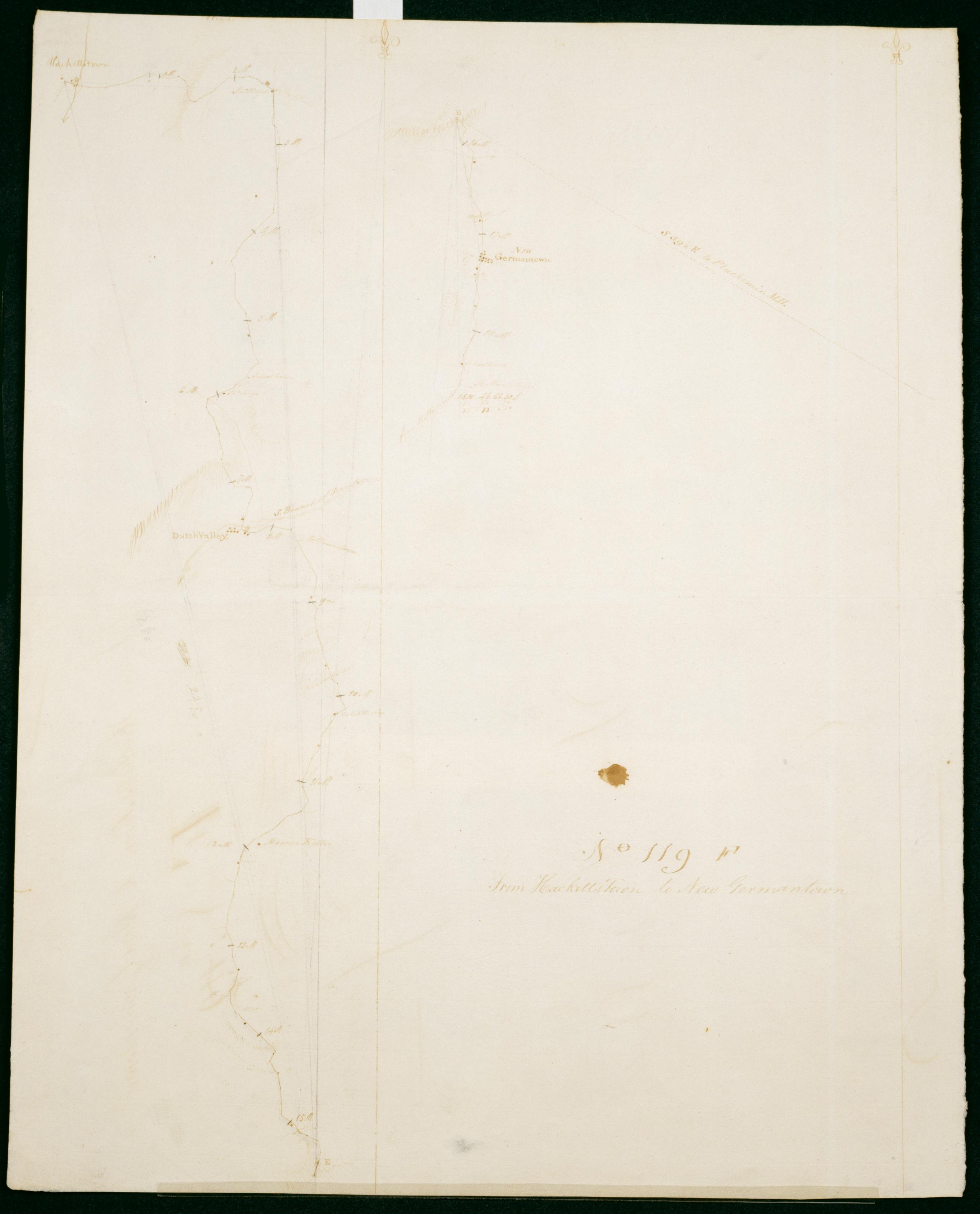
Cartographic From Hacketts Town to New Germantown. No 119, F / S De Witt Geographer to the Army of the United States ; by Robert Erskine F.R.S. Geogr. A. U.S. and Assistants. First statement of responsibility and detailed date from verso text: "Finis Jany 20th 1781 S De Witt Geographer to the Army of the United States". In erased pencil on recto: "No 119 F". Military topographic map. Covers the townships of Washington in Morris County and of Tewksbury in Hunterdon County, New Jersey. Shows roads running through Hackettstown, Drakestown, German Valley, Parker, Fairmont and New Germantown. Also shows buildings and owners' names, landforms and streams. Pen-and-ink, pencil on laid paper. Shows relief by hachures. Stained, soiled , creased and abraded. View Item
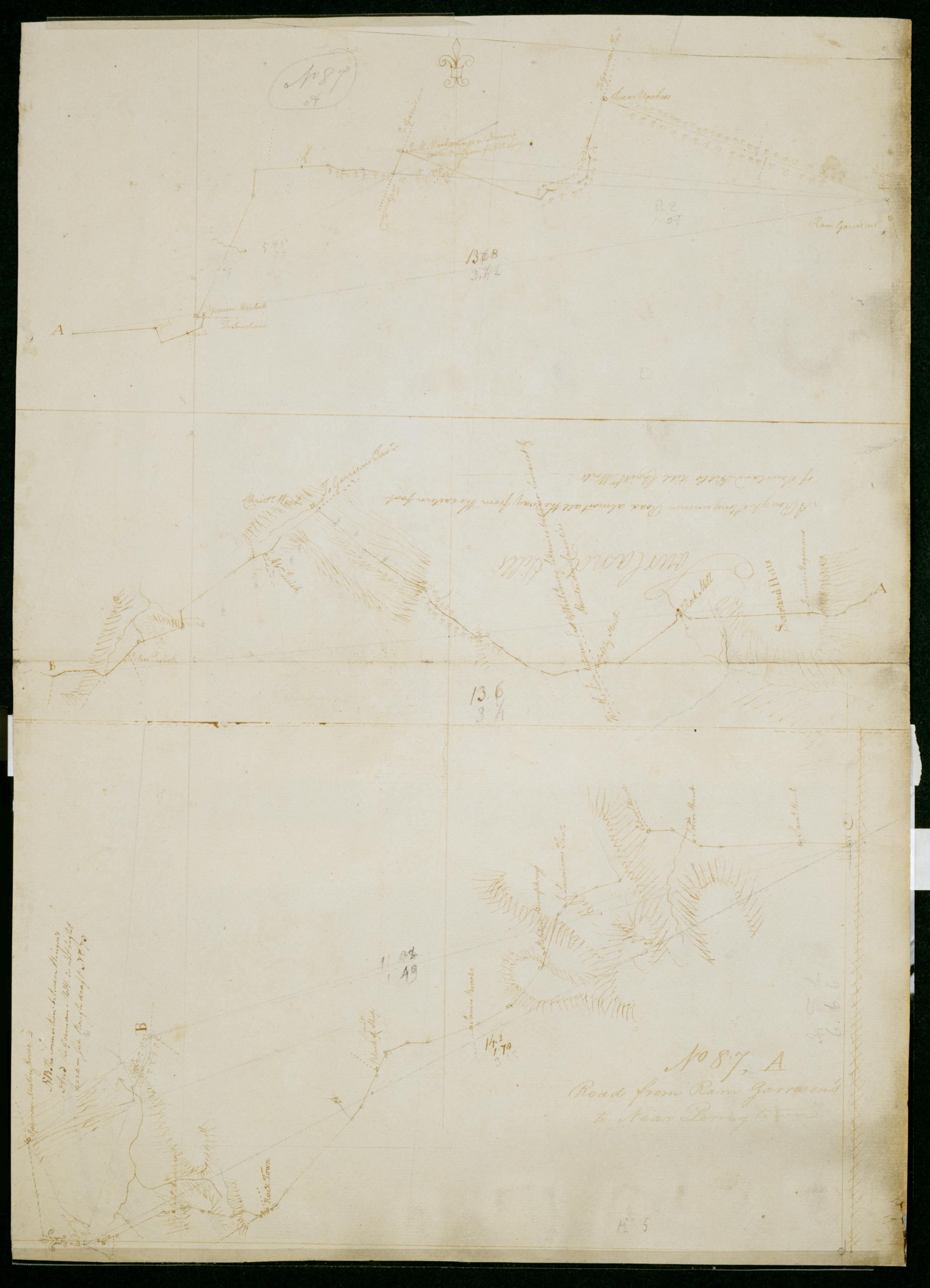
Cartographic Road from Ram Garrison's to Near Penny town. No 87, A / by Robert Erskine F.R.S. Geogr. A. U.S. and Assistants. In pencil on recto: "No 87 A". Military topographic map in three segments meant to be joined at points marked "A" and "B." Top and middle segments oriented with north to top of sheet; bottom segment oriented with north to left of sheet. Map covers the townships of Hillsboro and Montgomery in Somerset County, East Amwell and West Amwell in Hunterdon County and Hopewell in Mercer County, New Jersey. View Item
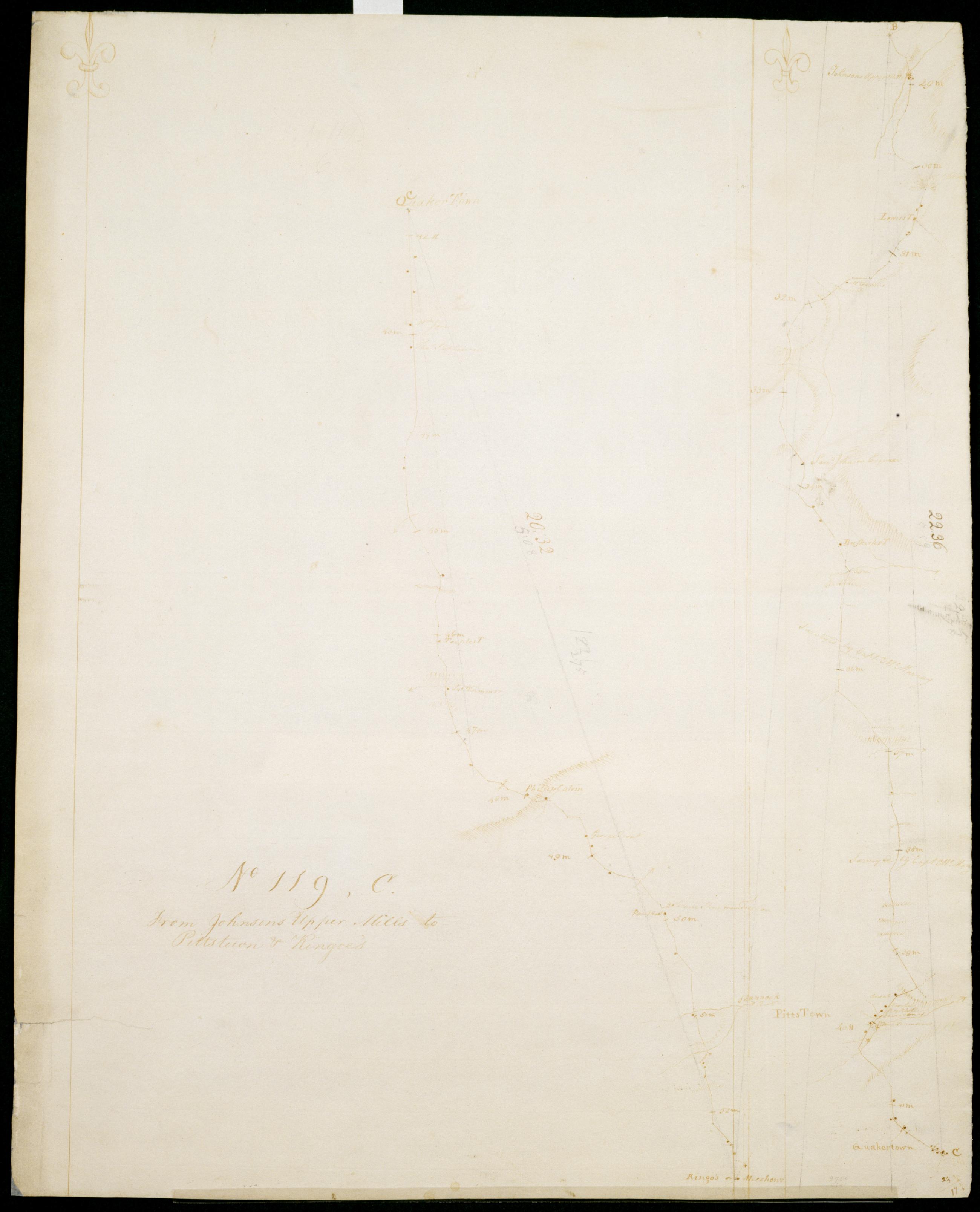
Cartographic From Johnsons Upper Mills to Pittstown + Ringoe's. No 119, C / S DeWitt Geographer to the Army of the United States ; by Robert Erskine F.R.S. Geogr. A. U.S. and Assistants. Date of 1780 or 1781 based on verso text to sheet 119,F of series. First statement of responsibility from verso text on sheet 119,F of series is echoed on verso of this sheet: "DeWitt DeWitt DeWitt SD SD SD DeWitt SD DeWitt" The map itself is labeled at two points, "Surveyed by Captn McMurray." Military topographic map; right segment fits north of the left one. Covers the townships of Lebanon, Bethlehem, Union and Franklin in Hunterdon County, and of Washington in Warren County, New Jersey. View Item
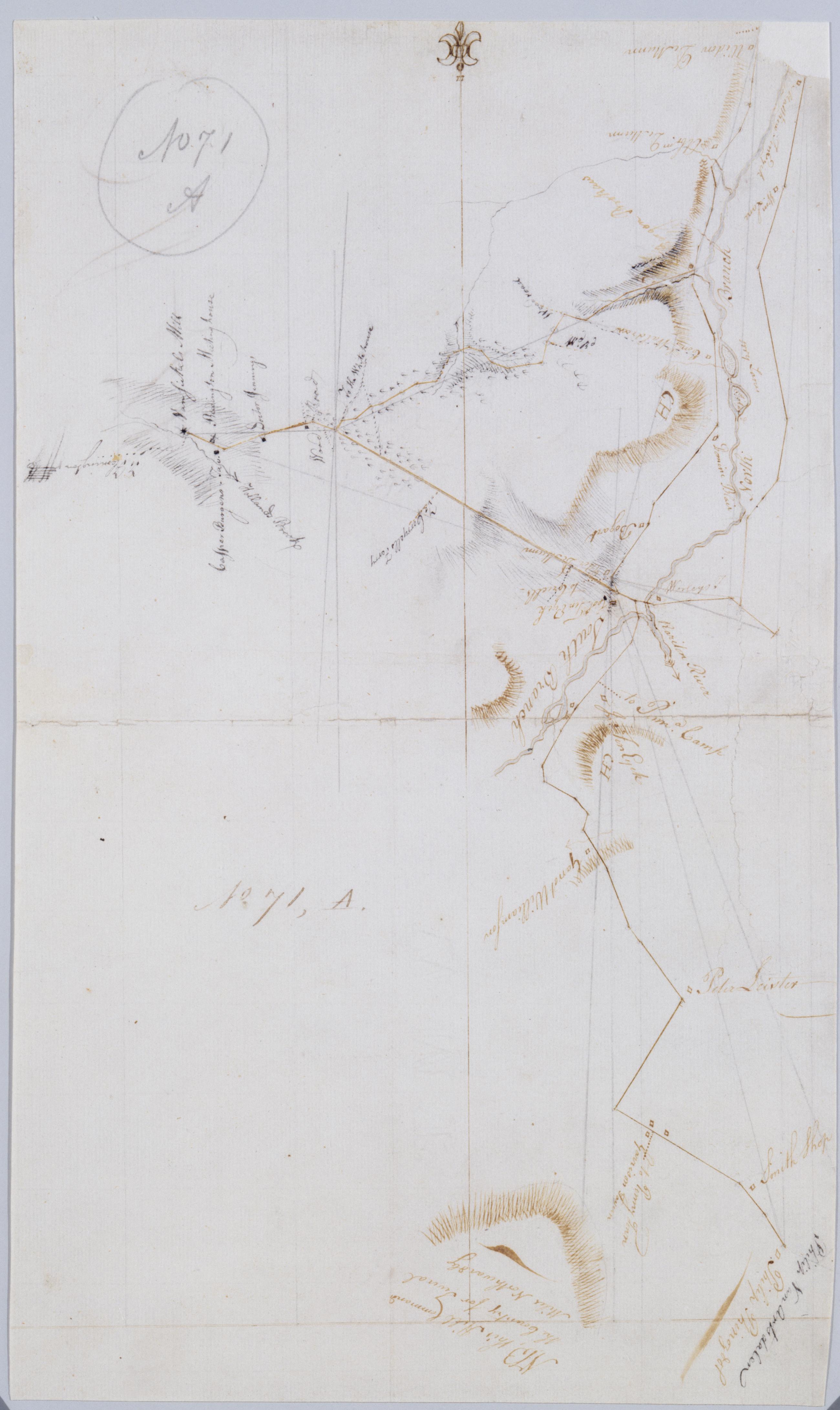
Cartographic [Garisons Somerset Boundbrook from South Branch to Reddington Brokaws] No. 71, A / by Robert Erskine F.R.S. Geogr. A. U.S. and Assistants. Foxed, creased, frayed and abraded. Mounted on cloth, bound and cropped, disbound and silked by subsequent owners. Cleaned after removal of backings 1999; some fill remains. Sheathed in mylar. In ink on verso: "A - 71". In pencil on recto "No 71 A". Military topographic map. Covers the townships of Readington and Branchburg in Hunterdon County and of Bridgewater and Hillsboro in Somerset County, New Jersey. Shows roads running through Readington, North Branch, Milltown, South Branch, Flagtown and Frankfort. Also shows buildings and owners' names, landforms and streams. View Item
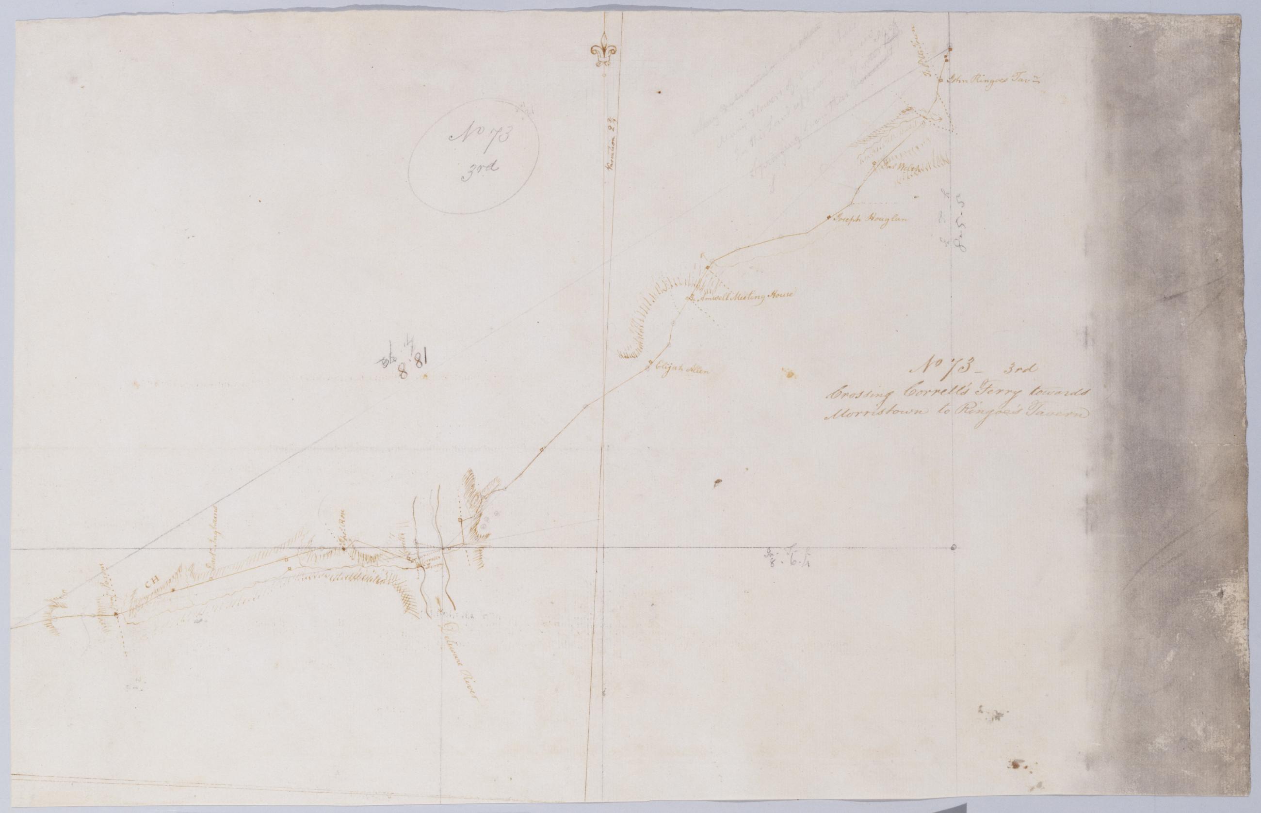
Cartographic Crossing Correll's Ferry towards Morristown to Ringoe's Tavern. No 73 - 3rd / by Robert Erskine F.R.S. Geogr. A. U.S. and Assistants. Heavily soiled, creased and abraded. Mounted on cloth, bound and cropped, disbound and silked by subsequent owners. Cleaned after removal of backings 1999; some fill remains. Sheathed in mylar. In pencil on recto: "No 73 3rd". Military topographic map. Covers the townships of Solebury in Bucks County, Pennsylvania, and of Delaware and West Amwell in Hunterdon County, New Jersey. Shows roads running through Deer Park and New Hope in Pennsylvania; Lambertville, Mount Airy and Ringoes in New Jersey. Also shows buildings and owners' names, landforms and streams. Pen-and-ink, pencil on laid paper. View Item
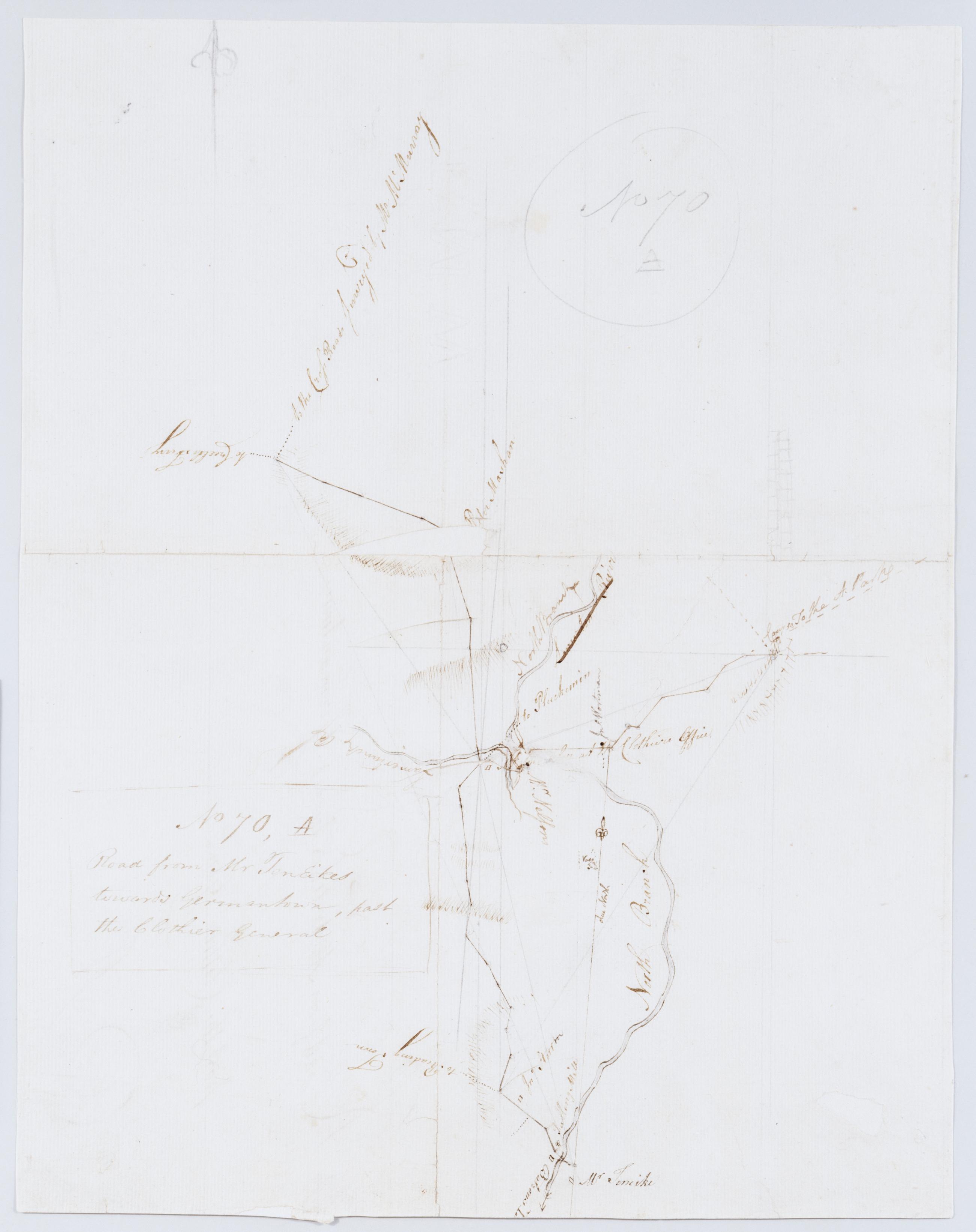
Cartographic Road from Mr TenEikes towards Germantown, past the Clothier General. No 70, A / by Robert Erskine F.R.S. Geogr. A. U.S. and Assistants. Foxed, creased, torn, frayed and abraded. Mounted on cloth, bound and cropped, disbound and silked by subsequent owners. Cleaned after removal of backings 1999; some fill remains. Lined with China paper. Sheathed in mylar. Imperfect: lacking 5 x 1 cm. at map center, 1 x 1 at lower right. In pencil on recto: "No 70 A". Military topographic map. Covers the townships of Bedminster and Bridgewater in Somerset County and of Branchburg in Hunterdon County, New Jersey. Shows roads running through Lamington, Burnt Mill, North Branch and Pluckemin. View Item
Cartographic From Potterstown towards Hickory Tavern. No 77, A / by Robert Erskine F.R.S. Geogr. A. U.S. and Assistants. In pencil on recto: "No 77 A". Military topographic map. Covers the townships of Clinton and Union in Hunterdon County, New Jersey. Shows roads running through Potterstown, Lebanon and Clinton (formerly Taylors Mills). Also shows buildings and owners' names, landforms and streams. Pen-and-ink, pencil on laid paper. Shows relief by hachures. Stained, foxed, creased and abraded. Mounted on cloth, bound and cropped, disbound and silked by subsequent owners. Cleaned after removal of backings 1999; some fill remains. Sheathed in mylar. View Item
Cartographic From near Ringoes towds the Union. No 119 D / S DeWitt Geographer to the Army of the United States ; by Robert Erskine F.R.S. Geogr. A. U.S. and Assistants. Date of 1780 or 1781 based on verso text to sheet 119-F of series. First statement of responsibility from verso text on sheet 119-F of series. Military topographic map. Covers the townships of Raritan and Franklin in Hunterdon County- New Jersey. Shows roads running through Clinton- Sidney- Cherryville- Klinesville- Flemington- Copper Hill- Muirhead and Larison Corner. Also shows buildings and owners' names- landforms and streams. Pen-and-ink- pencil on laid paper. Shows relief by hachures. Stained- soiled - creased and abraded. View Item
Cartographic From Muscanecunk Mountain Past Johnson's Forge to Easton. No 77 C / by Robert Erskine F.R.S. Geogr. A. U.S. and Assistants. In erased pencil on recto: "No 77 C". Military topographic map. Covers the townships of Greenwich and Pohatcong in Warren County and of Bethlehem in Hunterdon County- New Jersey; also covers part of Berks County- Pennsylvania. Shows roads running through Bloomsbury- Kennedy Mills- Still Valley and Phillipsburg in New Jersey as well as Easton- Pennsylvania. Also shows buildings and owners' names- landforms and streams. Pen-and-ink- pencil on laid paper. Shows relief by hachures. Title proper from recto is the work of a later editor--Simeon DeWitt or his assign--subsequent to 1820. View Item
Cartographic From letter B (on No 77 C) to the Road from Corrells to Morristown. No 77 D / by Robert Erskine F.R.S. Geogr. A. U.S. and Assistants. In erased pencil on recto: "No 77 C". Military topographic map. Covers the townships of Franklin and Readington in Hunterdon County- New Jersey. Shows roads running through Lansdowne- Hamden- Sunnyside- Stanton and Pleasant Run. Also shows buildings and owners' names- landforms and streams. Notice that the verso title's "Letter B of the same number" properly refers to sheet 77-B not to any mark on sheet 77-C. Pen-and-ink- pencil on laid paper. Shows relief by hachures. Title proper from recto is the work of a later editor--Simeon DeWitt or his assign--subsequent to 1820. View Item
Cartographic Road from near B Tavern to the White House. No 72 A / by Robert Erskine F.R.S. Geogr. A. U.S. and Assistants. Foxed- creased- cracked and abraded. Mounted on cloth- bound and cropped- disbound and silked by subsequent owners. Cleaned after removal of backings 1999; some fill remains. Sheathed in mylar. In pencil on recto: "No 72 A". Military topographic map. Covers the townships of Branchburg and Readington in Hunterdon County- New Jersey. Shows roads running through White House and North Branch. Also shows buildings and owners' names- landforms and streams. Pen-and-ink- pencil on laid paper. Shows relief by hachures. View Item
Cartographic Road from towards [sic] Potterstown past the Hickory Tavn towards Easton and from the Hickory T. toward Reddington No 77 B / by Robert Erskine F.R.S. Geogr. A. U.S. and Assistants. Military topographic map. Covers the townships of Union- Bethlehem and Alexandria in Hunterdon County- New Jersey. Shows roads running through Perryville- The Hickory- Swinesburg- Mechling Corner and Mt. Salem. Also shows buildings and owners' names- landforms and streams. Pen-and-ink- pencil on laid paper. Shows relief by hachures. Soiled- foxed- and abraded. Mounted on cloth- bound and cropped- disbound and silked by subsequent owners. Cleaned after removal of backings 1999; some fill remains. Sheathed in mylar. View Item
Cartographic Past the White House to the Cross roads towards Morristown crossing Lamatunck River. No 73 - 5th / by Robert Erskine F.R.S. Geogr. A. U.S. and Assistants. Foxed- creased and abraded. Mounted on cloth- bound and cropped- disbound and silked by subsequent owners. Cleaned after removal of backings 1999; some fill remains. Sheathed in mylar. In pencil on recto: "No 73 5th". Military topographic map. Covers the townships of Bedminster in Somerset County and of Readington and Tewksbury in Hunterdon County- New Jersey. Shows roads running through White House- Lamington and Greater Crossroads. Also shows buildings and owners' names- landforms and streams. Pen-and-ink- pencil on laid paper. Shows relief by hachures. View Item
Cartographic Road from the White House to Potter's town + from Potterstown to Germantown thence towards Lamertunk Meeting House. No 72 B / by Robert Erskine F.R.S. Geogr. A. U.S. and Assistants. Foxed- creased- cracked and abraded. Mounted on cloth- bound and cropped- disbound and silked by subsequent owners. Cleaned after removal of backings 1999; some fill remains. Sheathed in mylar. In pencil on recto: "No 72 B". Military topographic map. Covers the townships of Tewksbury and Readington in Hunterdon County- New Jersey. Shows roads running through New Germantown- Potterstown and White House. Also shows buildings and owners' names- landforms and streams. Oriented with north to left of sheet. Pen-and-ink- pencil on laid paper. Shows relief by hachures. View Item
Cartographic From near Ringoes crossing Newshannock River and the South Branch of Rariton - towards Morristown. No 73 - 4th / by Robert Erskine F.R.S. Geogr. A. U.S. and Assistants. Heavily soiled- frayed- creased and abraded. Mounted on cloth- bound and cropped- disbound and silked by subsequent owners. Cleaned after removal of backings 1999; some fill remains. Sheathed in mylar. In pencil on recto: "No 73 4th". Military topographic map. Covers the townships of East Amwell- Raritan and Readington in Hunterdon County- New Jersey. Shows roads running through Larison Corner- Reaville- Three Bridges and Pleasant Run. Also shows buildings and owners' names- landforms and streams. Pen-and-ink- pencil on laid paper. Shows relief by hachures. View Item
Cartographic Past the Union to Lewis's Tavern. No 119 E / S DeWitt Geographer to the Army of the United States ; by Robert Erskine F.R.S. Geogr. A. U.S. and Assistants. Date of 1780 or 1781 based on verso text to sheet 119-F of series. First statement of responsibility from verso text on sheet 119-F of series. In erased pencil on recto: "No 119 E". Military topographic map. Covers the townships of Bethlehem- Union and Franklin in Hunterdon County- New Jersey. Shows roads running through Polktown and Clinton. Also shows buildings and owners' names- landforms and streams. Pen-and-ink- pencil on laid paper. Shows relief by hachures. Stained- soiled - creased and abraded. Mounted on cloth- bound and cropped- disbound and silked by subsequent owners. View Item
Cartographic From near Henry Camps to Reddington. No 77. E / by Robert Erskine F.R.S. Geogr. A. U.S. and Assistants. Frayed and abraded. Mounted on cloth- cropped and bound- disbound and silked by subsequent owners. Cleaned after removal of backings 1999; some fill remains. Sheathed in mylar. In pencil on recto: "No 77 E". Military topographic map. Covers Readington Township in Hunterdon County- New Jersey. Shows roads running through Pleasant Run and Readington. Also shows buildings and owners' names- landforms and streams. Pen-and-ink- pencil on laid paper. Shows relief by hachures. Title proper from recto is the work of a later editor--Simeon DeWitt or his assign--subsequent to 1820. View Item
Cartographic From Hacketts Town to New Germantown. No 119 F / S De Witt Geographer to the Army of the United States ; by Robert Erskine F.R.S. Geogr. A. U.S. and Assistants. First statement of responsibility and detailed date from verso text: "Finis Jany 20th 1781 S De Witt Geographer to the Army of the United States". In erased pencil on recto: "No 119 F". Military topographic map. Covers the townships of Washington in Morris County and of Tewksbury in Hunterdon County- New Jersey. Shows roads running through Hackettstown- Drakestown- German Valley- Parker- Fairmont and New Germantown. Also shows buildings and owners' names- landforms and streams. Pen-and-ink- pencil on laid paper. Shows relief by hachures. Stained- soiled - creased and abraded. View Item
Cartographic Road from Ram Garrison's to Near Penny town. No 87 A / by Robert Erskine F.R.S. Geogr. A. U.S. and Assistants. In pencil on recto: "No 87 A". Military topographic map in three segments meant to be joined at points marked "A" and "B." Top and middle segments oriented with north to top of sheet; bottom segment oriented with north to left of sheet. Map covers the townships of Hillsboro and Montgomery in Somerset County- East Amwell and West Amwell in Hunterdon County and Hopewell in Mercer County- New Jersey. View Item
Cartographic From Johnsons Upper Mills to Pittstown + Ringoe's. No 119 C / S DeWitt Geographer to the Army of the United States ; by Robert Erskine F.R.S. Geogr. A. U.S. and Assistants. Date of 1780 or 1781 based on verso text to sheet 119-F of series. First statement of responsibility from verso text on sheet 119-F of series is echoed on verso of this sheet: "DeWitt DeWitt DeWitt SD SD SD DeWitt SD DeWitt" The map itself is labeled at two points- "Surveyed by Captn McMurray." Military topographic map; right segment fits north of the left one. Covers the townships of Lebanon- Bethlehem- Union and Franklin in Hunterdon County- and of Washington in Warren County- New Jersey. View Item