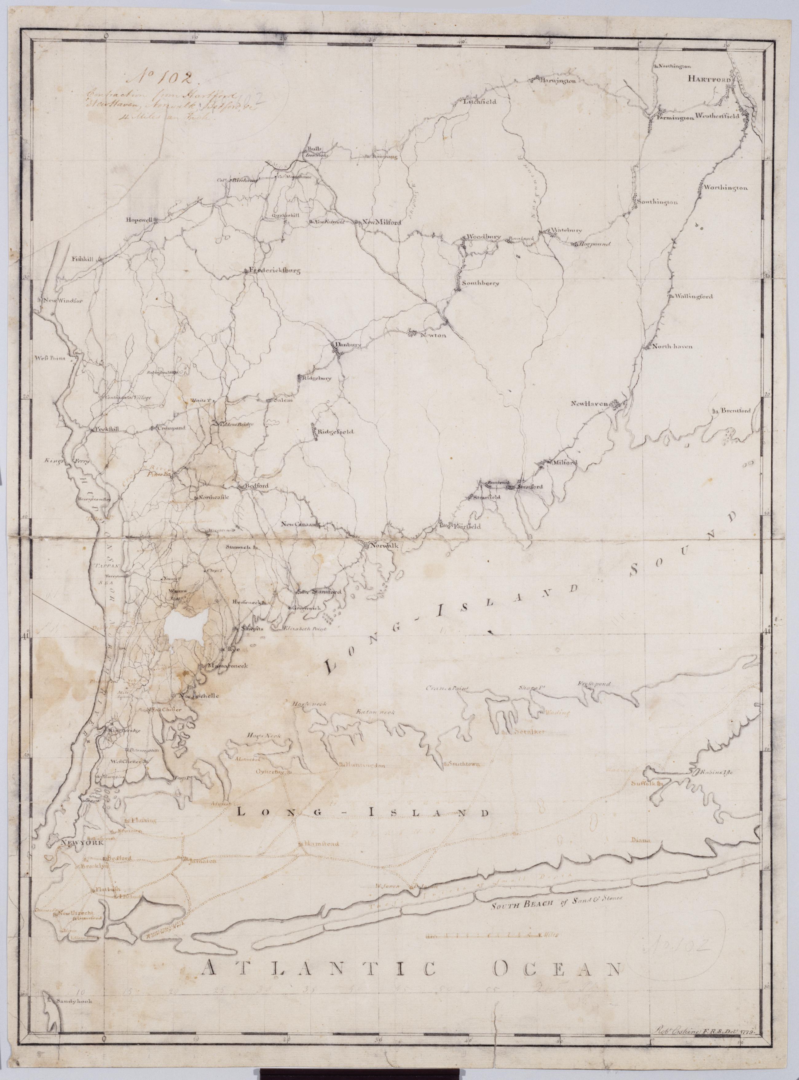
Cartographic Contraction from Hartford New Haven, Norwalk, Bedford +c. No 102 / Robt Erskine F.R.S. Delt. 1779 ; by RE ; by Robert Erskine F.R.S. Geogr. A. U.S. and Assistants. Imperfect: lacking 2 x 3 cm. at left center. In ink on verso: "No. 102". In pencil on recto: "No 102". Military topographic map. Covers Westchester, Putnam, Nassau and Suffolk counties in New York, and also New York City; and Fairfield, Litchfield, New Haven and Hartford Counties in Connecticut. Pen-and-ink, pencil on laid paper. Planar projection. Soiled, stained, mildewed creased, frayed and abraded. Mounted on cloth, bound, disbound and silked by subsequent owners. Cleaned after removal of backings 1999; relined with China paper. Sheathed in mylar. View Item
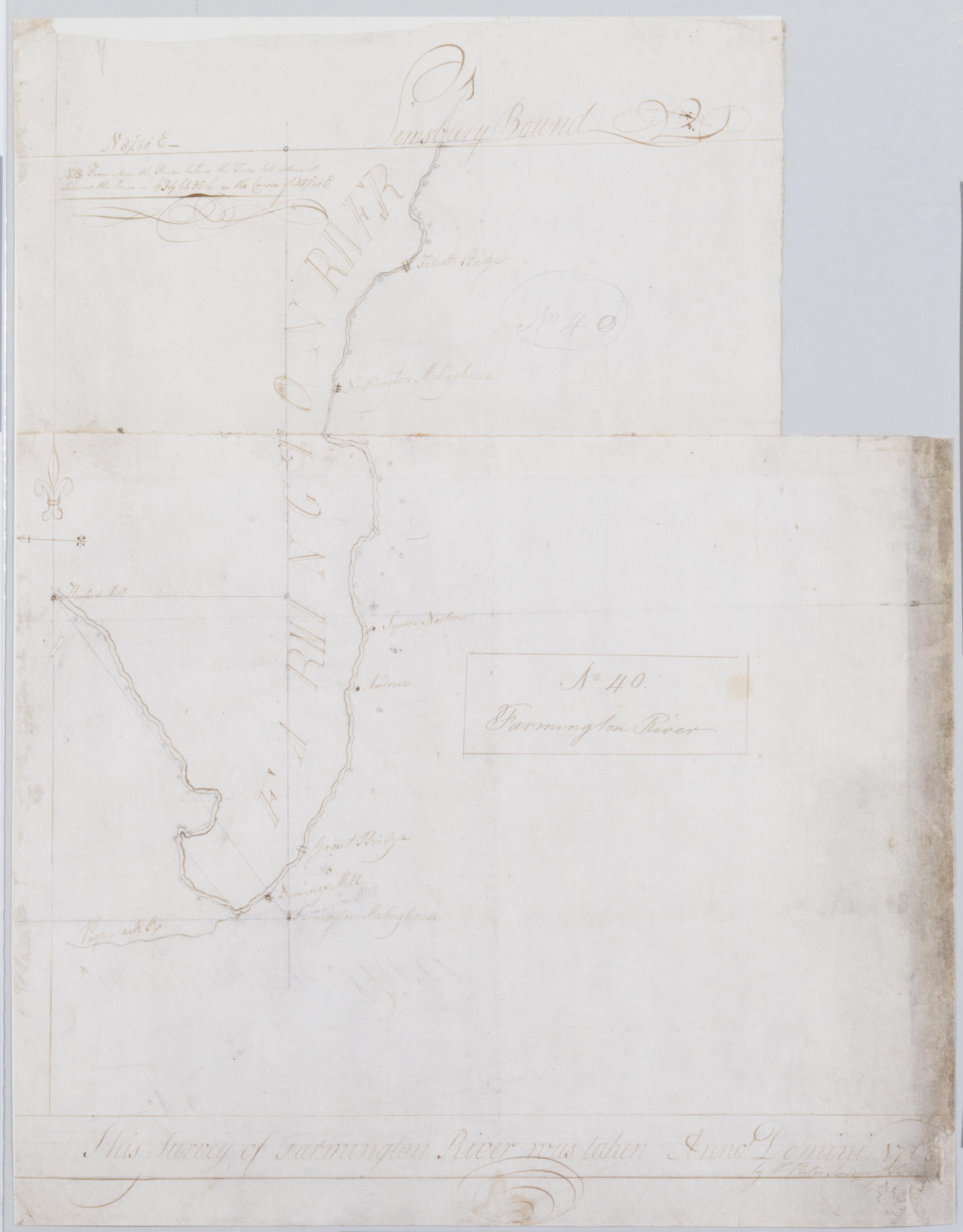
Cartographic Farmington River. No 40 / this survey of Farmington River was taken Anno Domini 1765 by Mr. Porter Surveyor of Farmin[gton] ; by Robert Erskine F.R.S. Geogr. A. U.S. and Assistants ; the bearings taken by Mr. Porter. Handwriting examination shows that this is a copy by Erskine of Porter's original. In pencil on recto: "No 40". Military topographic map. Covers the towns of Simsbury, Avon and Farmington in Hartford County, Connecticut. Shows buildings and owners' names, course of the river. Pen-and-ink, pencil on laid paper. Stained, frayed, and abraded. Mounted on cloth, bound and cropped, disbound and silked by subsequent owners. Cleaned after removal of backings 1999; some fill remains. Sheathed in mylar. View Item
Cartographic Contraction from Hartford New Haven Norwalk Bedford +c. No 102 / Robt Erskine F.R.S. Delt. 1779 ; by RE ; by Robert Erskine F.R.S. Geogr. A. U.S. and Assistants. Imperfect: lacking 2 x 3 cm. at left center. In ink on verso: "No. 102". In pencil on recto: "No 102". Military topographic map. Covers Westchester- Putnam- Nassau and Suffolk counties in New York- and also New York City; and Fairfield- Litchfield- New Haven and Hartford Counties in Connecticut. Pen-and-ink- pencil on laid paper. Planar projection. Soiled- stained- mildewed creased- frayed and abraded. Mounted on cloth- bound- disbound and silked by subsequent owners. Cleaned after removal of backings 1999; relined with China paper. Sheathed in mylar. View Item
Cartographic Farmington River. No 40 / this survey of Farmington River was taken Anno Domini 1765 by Mr. Porter Surveyor of Farmin[gton] ; by Robert Erskine F.R.S. Geogr. A. U.S. and Assistants ; the bearings taken by Mr. Porter. Handwriting examination shows that this is a copy by Erskine of Porter's original. In pencil on recto: "No 40". Military topographic map. Covers the towns of Simsbury- Avon and Farmington in Hartford County- Connecticut. Shows buildings and owners' names- course of the river. Pen-and-ink- pencil on laid paper. Stained- frayed- and abraded. Mounted on cloth- bound and cropped- disbound and silked by subsequent owners. Cleaned after removal of backings 1999; some fill remains. Sheathed in mylar. View Item