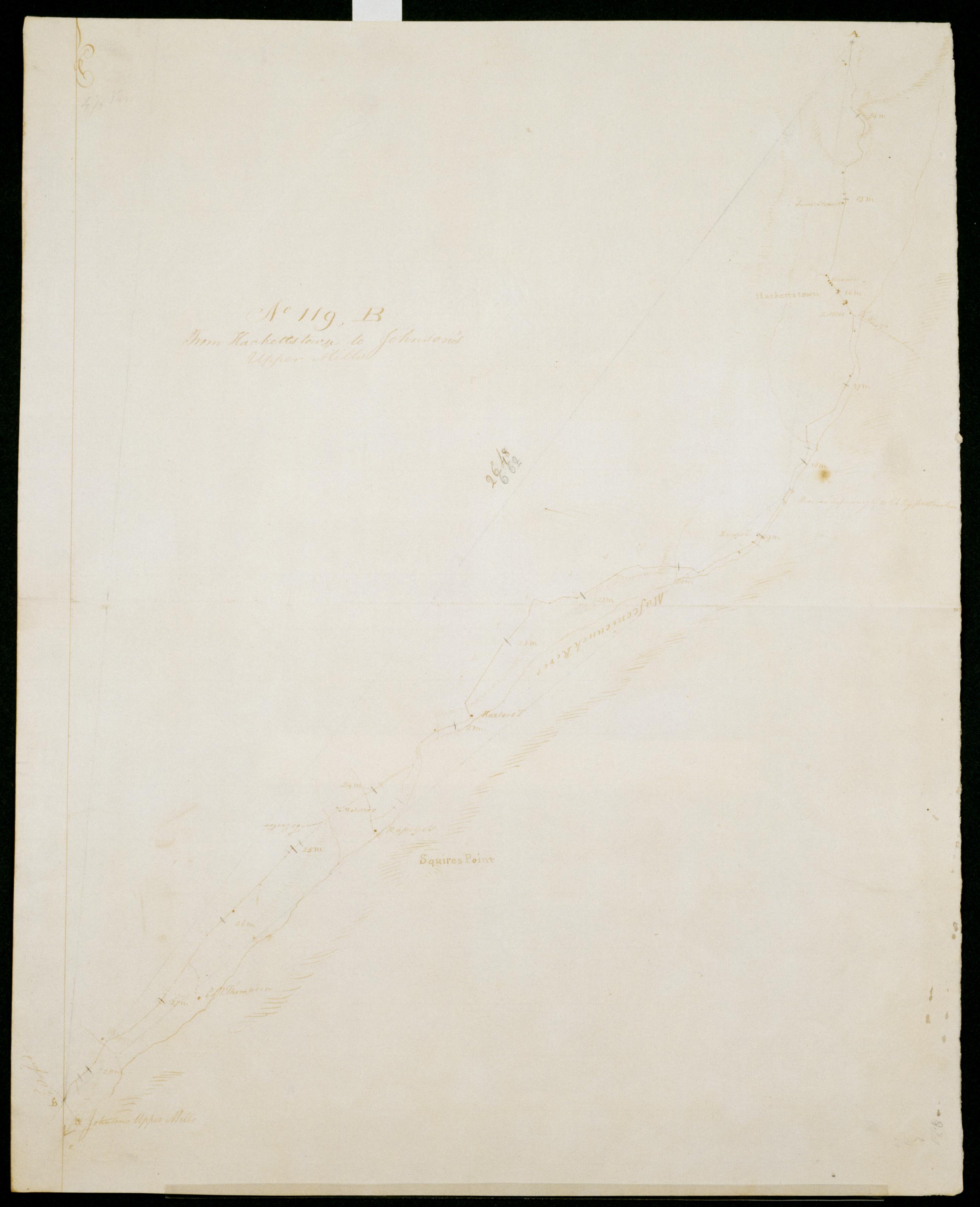
Cartographic From Hackettstown to Johnson's Upper Mills. No 119, B / S DeWitt Geographer to the Army of the United States ; by Robert Erskine F.R.S. Geogr. A. U.S. and Assistants. Date of 1780 or 1781 based on verso text to sheet 119,F of series. First statement of responsibility from verso text on sheet 119,F of series. In erased pencil on recto: "No 119 ..." Military topographic map. Covers the townships of Allamuchy, Independence, Mansfield and Washington in Warren County, New Jersey. Shows roads running through Hackettstown, Beatyestown, Penwell and Anderson. Also shows buildings and owners' names, landforms and streams. Pen-and-ink, pencil on laid paper. Shows relief by hachures. Stained, soiled , creased and abraded. View Item
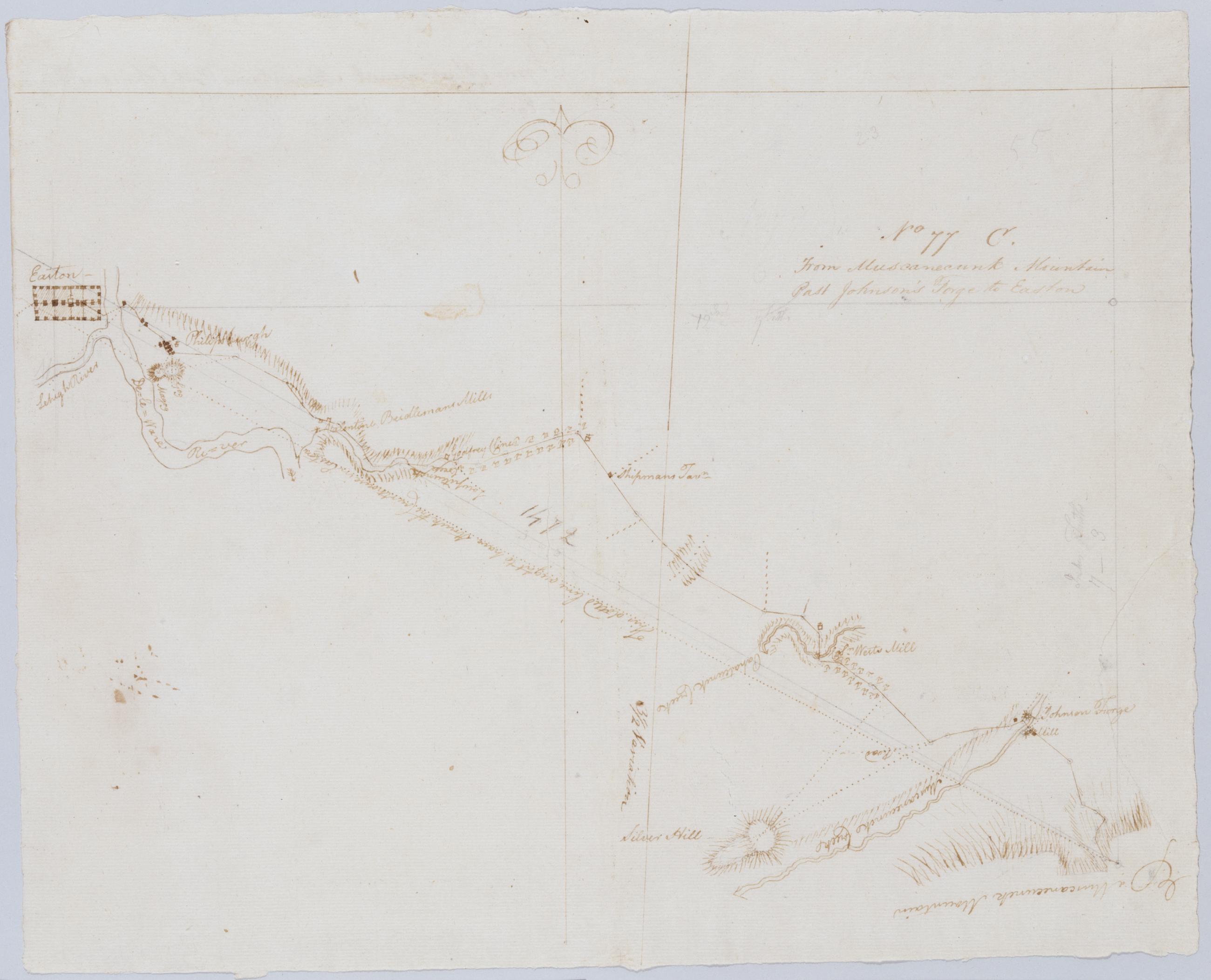
Cartographic From Muscanecunk Mountain Past Johnson's Forge to Easton. No 77 C / by Robert Erskine F.R.S. Geogr. A. U.S. and Assistants. In erased pencil on recto: "No 77 C". Military topographic map. Covers the townships of Greenwich and Pohatcong in Warren County and of Bethlehem in Hunterdon County, New Jersey; also covers part of Berks County, Pennsylvania. Shows roads running through Bloomsbury, Kennedy Mills, Still Valley and Phillipsburg in New Jersey as well as Easton, Pennsylvania. Also shows buildings and owners' names, landforms and streams. Pen-and-ink, pencil on laid paper. Shows relief by hachures. Title proper from recto is the work of a later editor--Simeon DeWitt or his assign--subsequent to 1820. View Item
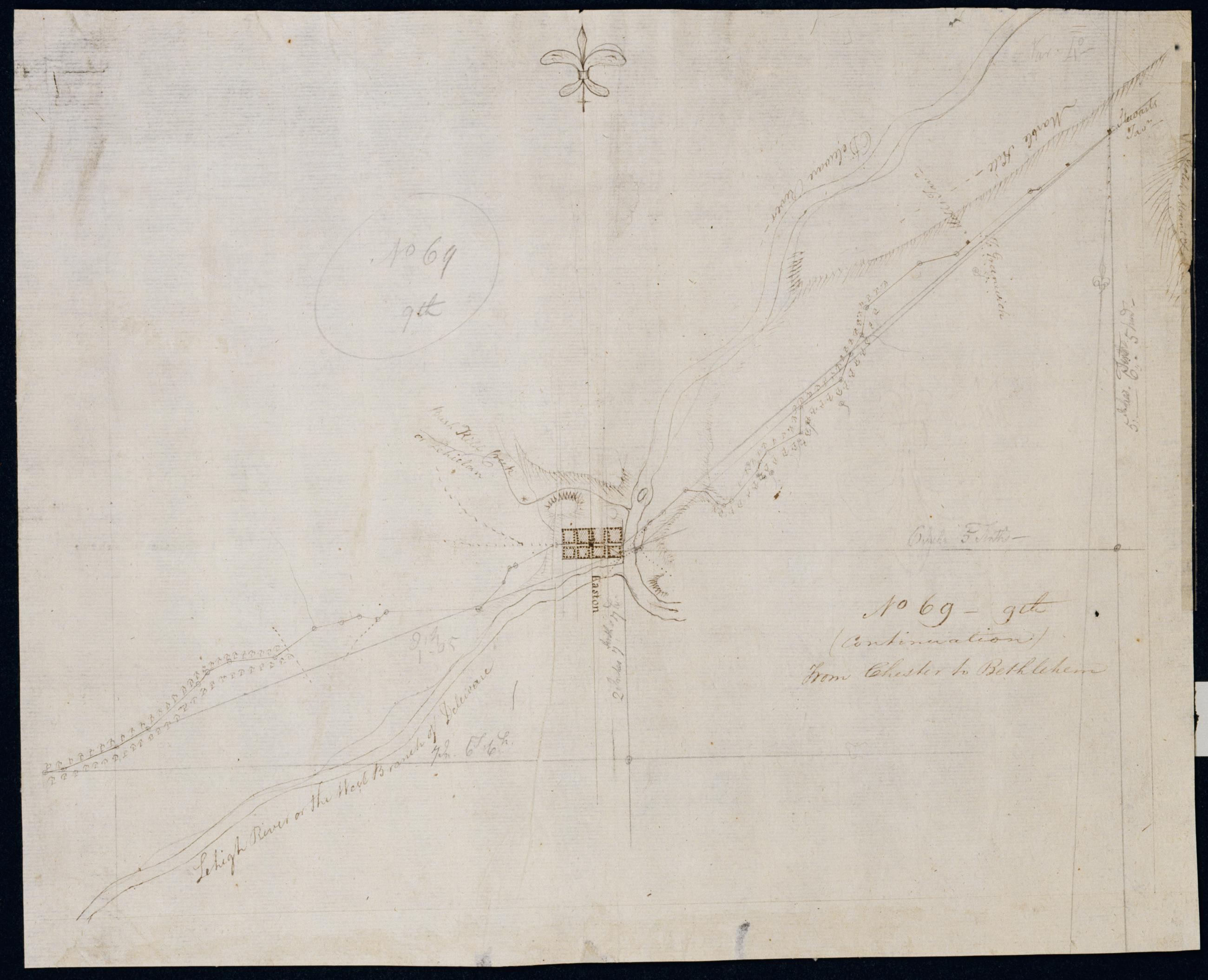
Cartographic (Continuation) From Chester to Bethlehem. No 69-9th / by Robert Erskine F.R.S. Geogr. A. U.S. and Assistants. In pencil on recto: "No 69 9th". Military topographic map. Covers the townships of Harmony and Lopatcong in Warren County, New Jersey, and of Easton and Bethlehem in Northampton County, Pennsylvania. Shows roads running through Phillipsburg, N.J., Easton and Farmersville, Pennsylvania. Also shows buildings and owners' names, landforms and streams. Pen-and-ink, pencil on laid paper. Shows relief by hachures. Stained, creased and abraded. Mounted on cloth, bound and cropped, disbound and silked by subsequent owners. Cleaned after removal of backings 1999; some fill remains. Sheathed in mylar. View Item
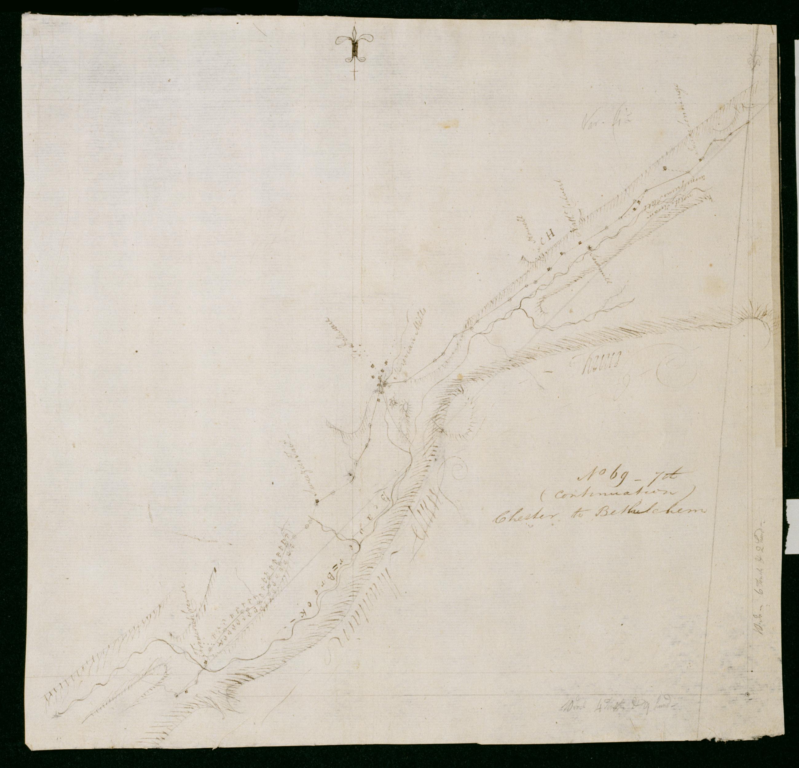
Cartographic (Continuation) Chester to Bethlehem. No 69-7th / by Robert Erskine F.R.S. Geogr. A. U.S. and Assistants. In pencil on recto: "No 69 7th". Military topographic map. Covers the townships of Frelinghuysen and Hope in Warren County, New Jersey. Shows roads running through Hope. Also shows buildings and owners' names, landforms and streams. Pen-and-ink, pencil on laid paper. Shows relief by hachures. Stained, creased and abraded. Mounted on cloth, bound and cropped, disbound and silked by subsequent owners. Cleaned after removal of backings 1999; some fill remains. Sheathed in mylar. Title proper on recto is the work of a later editor--Simeon DeWitt or his assign--subsequent to 1820. View Item
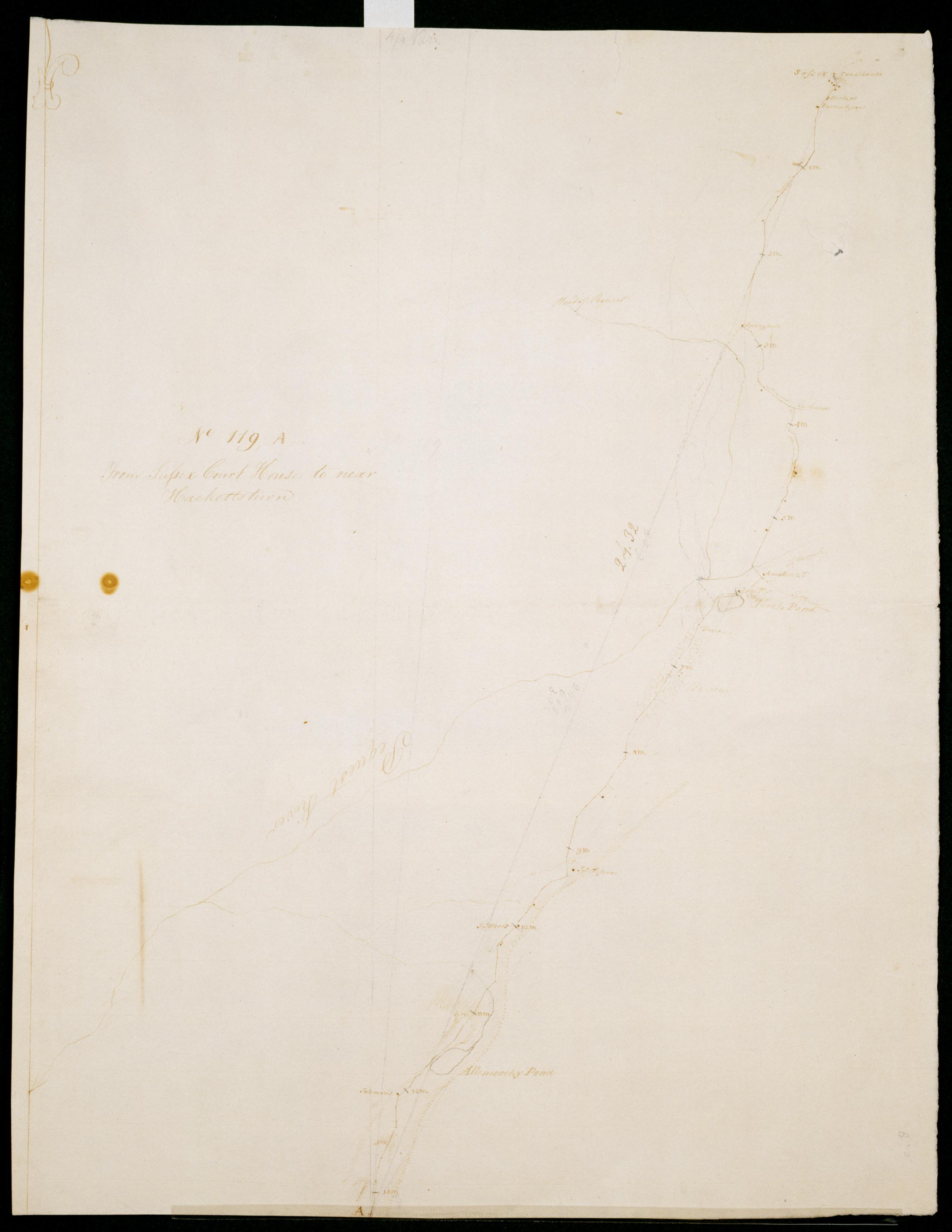
Cartographic From Sussex Court House to near Hackettstown. No 119, A / S DeWitt Geographer to the Army of the United States ; by Robert Erskine F.R.S. Geogr. A. U.S. and Assistants. Date of 1780 or 1781 based on verso text to sheet 119,F of series. First statement of responsibility from verso text on sheet 119,F of series. In erased pencil on recto: "No 119 A". Military topographic map. Covers the townships of Newton, Andover and Green in Sussex County and of Allamuchy in Warren County, New Jersey. Shows roads running through Newton, Brighton, Huntsville, Tranquillity and Warrenville. Also shows buildings and owners' names, landforms and streams. Pen-and-ink, pencil on laid paper. Shows relief by hachures. Stained, soiled , creased and abraded. View Item
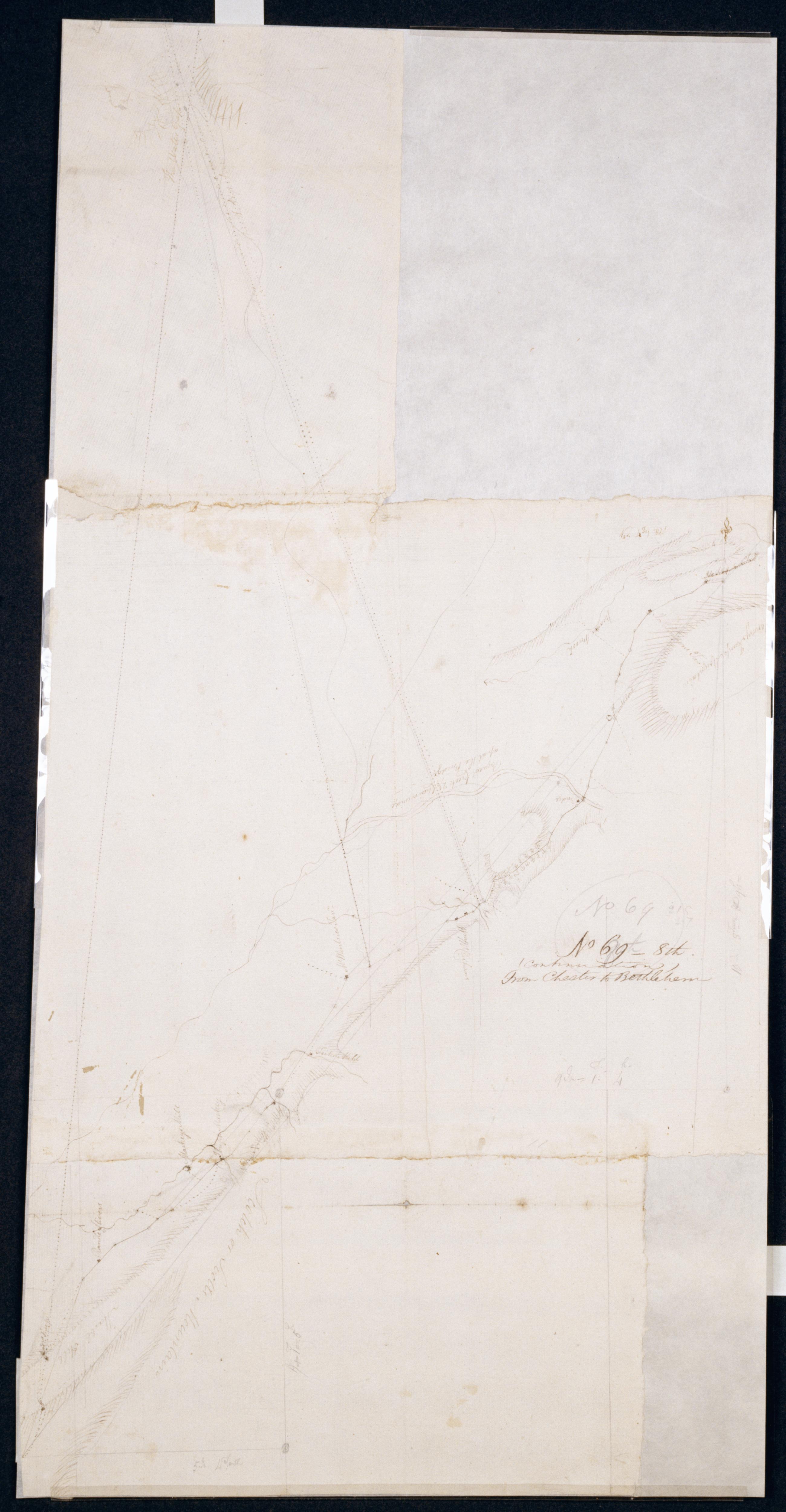
Cartographic (Continuation) From Chester to Bethlehem. No 69-8th / by Robert Erskine F.R.S. Geogr. A. U.S. and Assistants. Coordinates describe only that area of map showing the road, not the Delaware River and its watergap to north. In pencil on recto: "No 69 8th". Military topographic map. Covers the townships of Hope, Oxford and Harmony in Warren County, New Jersey. Shows roads running through Swayze Mills and Oxford Church. Also shows buildings and owners' names, landforms and streams. Pen-and-ink, pencil on laid paper. Shows relief by hachures. Stained, creased and abraded. Mounted on cloth, bound and cropped, disbound and silked by subsequent owners. View Item
Cartographic From Johnsons Upper Mills to Pittstown + Ringoe's. No 119, C / S DeWitt Geographer to the Army of the United States ; by Robert Erskine F.R.S. Geogr. A. U.S. and Assistants. Date of 1780 or 1781 based on verso text to sheet 119,F of series. First statement of responsibility from verso text on sheet 119,F of series is echoed on verso of this sheet: "DeWitt DeWitt DeWitt SD SD SD DeWitt SD DeWitt" The map itself is labeled at two points, "Surveyed by Captn McMurray." Military topographic map; right segment fits north of the left one. Covers the townships of Lebanon, Bethlehem, Union and Franklin in Hunterdon County, and of Washington in Warren County, New Jersey. View Item
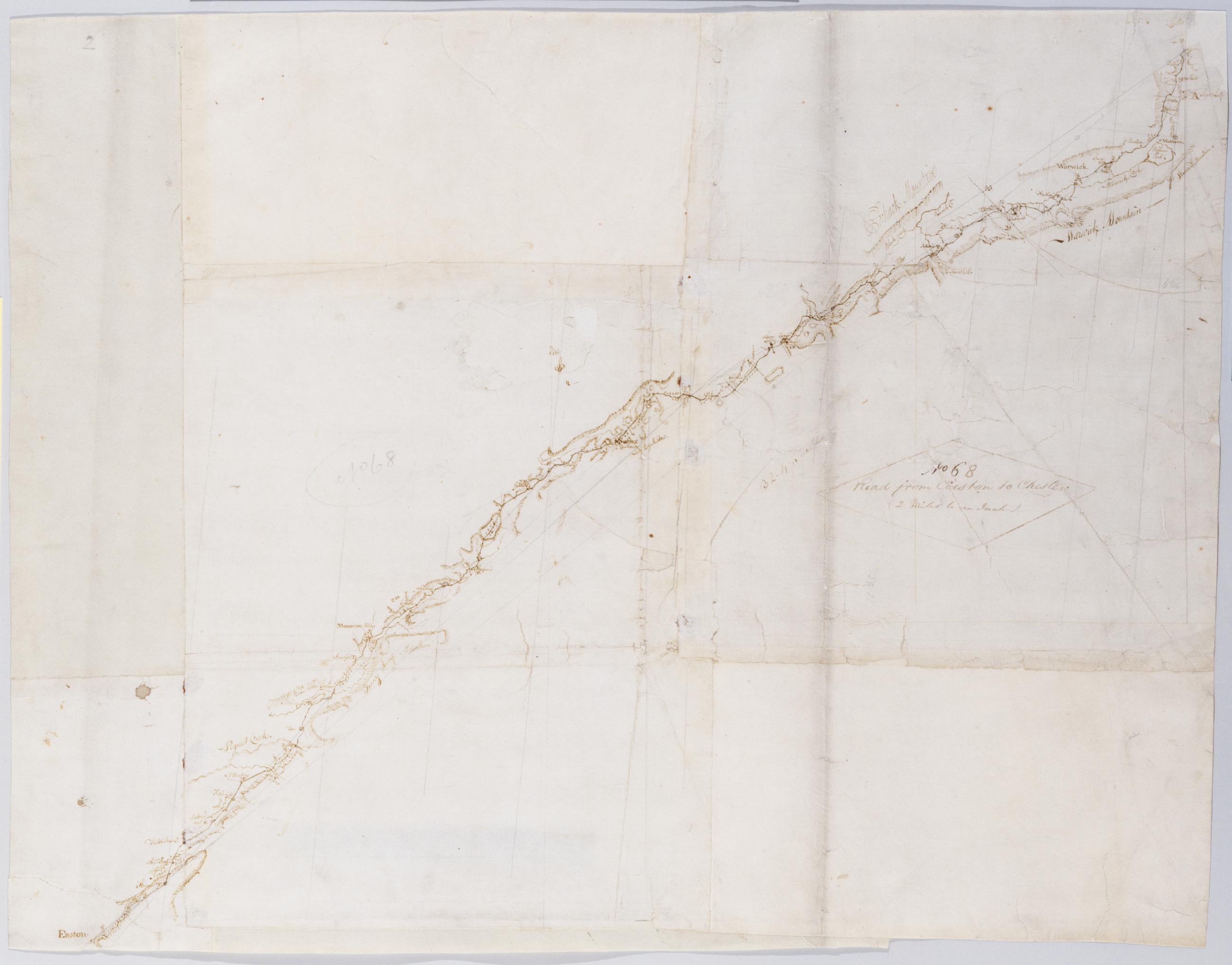
Cartographic Road from Easton to Chester (2 Miles to an Inch). No 68 / by Robert Erskine F.R.S. Geogr. A. U.S. and Assistants. Military topographic map. Covers Orange County in New York and Sussex and Warren counties in New Jersey. Shows roads running through East Chester, Sugarloaf, Warwick and New Milford in New York; and Maple Grange, Vernon, Hamburg, North Church, Newton (formerly Sussex), Hope, Swayze Mills, Oxford Church and Phillipsburg in New Jersey. Also shows buildings and owners' names, landforms and streams. Pen-and-ink, pencil on 3 assembled pieces laid paper; 4 pieces having a wove finish added later. Shows relief by hachures. Stained, foxed, creased, torn, frayed and abraded. View Item
Cartographic From Hackettstown to Johnson's Upper Mills. No 119 B / S DeWitt Geographer to the Army of the United States ; by Robert Erskine F.R.S. Geogr. A. U.S. and Assistants. Date of 1780 or 1781 based on verso text to sheet 119-F of series. First statement of responsibility from verso text on sheet 119-F of series. In erased pencil on recto: "No 119 ..." Military topographic map. Covers the townships of Allamuchy- Independence- Mansfield and Washington in Warren County- New Jersey. Shows roads running through Hackettstown- Beatyestown- Penwell and Anderson. Also shows buildings and owners' names- landforms and streams. Pen-and-ink- pencil on laid paper. Shows relief by hachures. Stained- soiled - creased and abraded. View Item
Cartographic From Muscanecunk Mountain Past Johnson's Forge to Easton. No 77 C / by Robert Erskine F.R.S. Geogr. A. U.S. and Assistants. In erased pencil on recto: "No 77 C". Military topographic map. Covers the townships of Greenwich and Pohatcong in Warren County and of Bethlehem in Hunterdon County- New Jersey; also covers part of Berks County- Pennsylvania. Shows roads running through Bloomsbury- Kennedy Mills- Still Valley and Phillipsburg in New Jersey as well as Easton- Pennsylvania. Also shows buildings and owners' names- landforms and streams. Pen-and-ink- pencil on laid paper. Shows relief by hachures. Title proper from recto is the work of a later editor--Simeon DeWitt or his assign--subsequent to 1820. View Item
Cartographic (Continuation) From Chester to Bethlehem. No 69-9th / by Robert Erskine F.R.S. Geogr. A. U.S. and Assistants. In pencil on recto: "No 69 9th". Military topographic map. Covers the townships of Harmony and Lopatcong in Warren County- New Jersey- and of Easton and Bethlehem in Northampton County- Pennsylvania. Shows roads running through Phillipsburg- N.J.- Easton and Farmersville- Pennsylvania. Also shows buildings and owners' names- landforms and streams. Pen-and-ink- pencil on laid paper. Shows relief by hachures. Stained- creased and abraded. Mounted on cloth- bound and cropped- disbound and silked by subsequent owners. Cleaned after removal of backings 1999; some fill remains. Sheathed in mylar. View Item
Cartographic (Continuation) Chester to Bethlehem. No 69-7th / by Robert Erskine F.R.S. Geogr. A. U.S. and Assistants. In pencil on recto: "No 69 7th". Military topographic map. Covers the townships of Frelinghuysen and Hope in Warren County- New Jersey. Shows roads running through Hope. Also shows buildings and owners' names- landforms and streams. Pen-and-ink- pencil on laid paper. Shows relief by hachures. Stained- creased and abraded. Mounted on cloth- bound and cropped- disbound and silked by subsequent owners. Cleaned after removal of backings 1999; some fill remains. Sheathed in mylar. Title proper on recto is the work of a later editor--Simeon DeWitt or his assign--subsequent to 1820. View Item
Cartographic From Sussex Court House to near Hackettstown. No 119 A / S DeWitt Geographer to the Army of the United States ; by Robert Erskine F.R.S. Geogr. A. U.S. and Assistants. Date of 1780 or 1781 based on verso text to sheet 119-F of series. First statement of responsibility from verso text on sheet 119-F of series. In erased pencil on recto: "No 119 A". Military topographic map. Covers the townships of Newton- Andover and Green in Sussex County and of Allamuchy in Warren County- New Jersey. Shows roads running through Newton- Brighton- Huntsville- Tranquillity and Warrenville. Also shows buildings and owners' names- landforms and streams. Pen-and-ink- pencil on laid paper. Shows relief by hachures. Stained- soiled - creased and abraded. View Item
Cartographic (Continuation) From Chester to Bethlehem. No 69-8th / by Robert Erskine F.R.S. Geogr. A. U.S. and Assistants. Coordinates describe only that area of map showing the road- not the Delaware River and its watergap to north. In pencil on recto: "No 69 8th". Military topographic map. Covers the townships of Hope- Oxford and Harmony in Warren County- New Jersey. Shows roads running through Swayze Mills and Oxford Church. Also shows buildings and owners' names- landforms and streams. Pen-and-ink- pencil on laid paper. Shows relief by hachures. Stained- creased and abraded. Mounted on cloth- bound and cropped- disbound and silked by subsequent owners. View Item
Cartographic From Johnsons Upper Mills to Pittstown + Ringoe's. No 119 C / S DeWitt Geographer to the Army of the United States ; by Robert Erskine F.R.S. Geogr. A. U.S. and Assistants. Date of 1780 or 1781 based on verso text to sheet 119-F of series. First statement of responsibility from verso text on sheet 119-F of series is echoed on verso of this sheet: "DeWitt DeWitt DeWitt SD SD SD DeWitt SD DeWitt" The map itself is labeled at two points- "Surveyed by Captn McMurray." Military topographic map; right segment fits north of the left one. Covers the townships of Lebanon- Bethlehem- Union and Franklin in Hunterdon County- and of Washington in Warren County- New Jersey. View Item
Cartographic Road from Easton to Chester (2 Miles to an Inch). No 68 / by Robert Erskine F.R.S. Geogr. A. U.S. and Assistants. Military topographic map. Covers Orange County in New York and Sussex and Warren counties in New Jersey. Shows roads running through East Chester- Sugarloaf- Warwick and New Milford in New York; and Maple Grange- Vernon- Hamburg- North Church- Newton (formerly Sussex)- Hope- Swayze Mills- Oxford Church and Phillipsburg in New Jersey. Also shows buildings and owners' names- landforms and streams. Pen-and-ink- pencil on 3 assembled pieces laid paper; 4 pieces having a wove finish added later. Shows relief by hachures. Stained- foxed- creased- torn- frayed and abraded. View Item