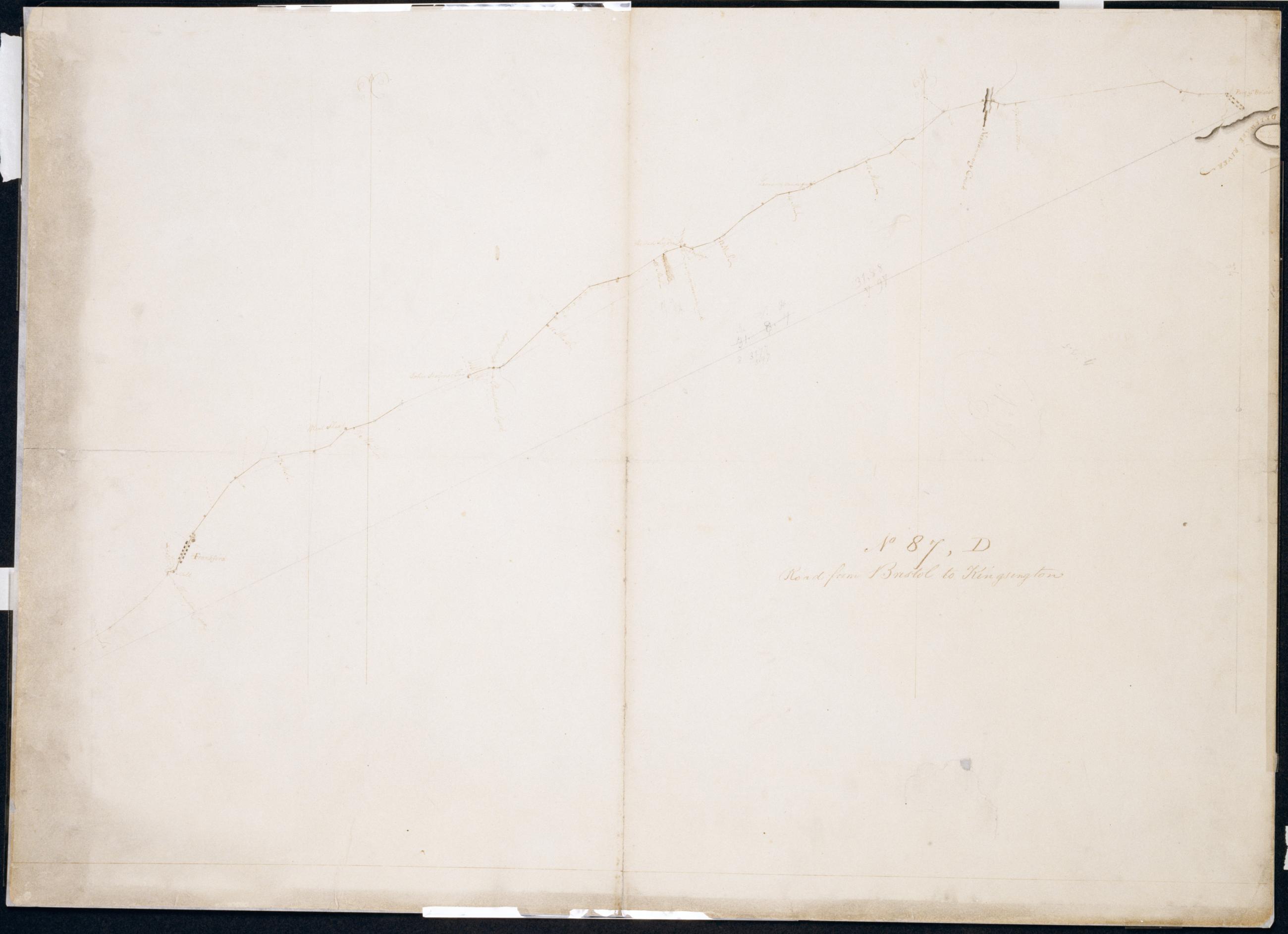
Cartographic Road from Bristol to Kingsington. No 87, D / by Robert Erskine F.R.S. Geogr. A. U.S. and Assistants. In pencil on recto: "No 87 D". Military topographic map. Covers the city of Philadelphia and the townships of Bristol and Bensalem in Bucks County, Pennsylvania. Shows roads running through Bristol, Eddington, Maud, Andalusia, Holmesburg and Frankford, now in Philadelphia. Also shows buildings and owners' names, landforms and streams. Pen-and-ink, pencil on laid paper. Shows relief by hachures. Soiled, creased, torn, frayed and abraded. Mounted on cloth, cropped, bound, disbound and silked by subsequent owners. Cleaned after removal of backings 1999; some fill remains. Lined with China paper. View Item
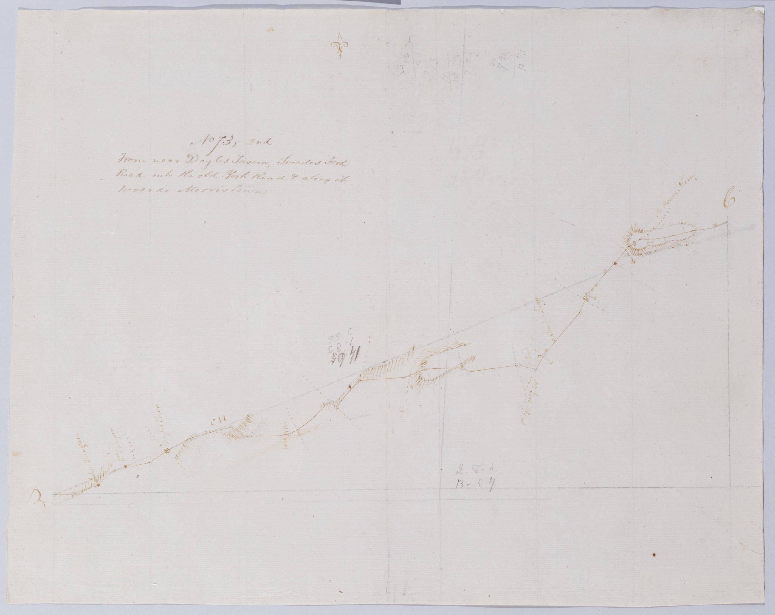
Cartographic From near Doyles Tavern, Swedes Ford Road into the old York Road + along it towards Morristown. No 73, 2nd / by Robert Erskine F.R.S. Geogr. A. U.S. and Assistants. Creased, torn, frayed and abraded. Mounted on cloth, bound and cropped, disbound and silked by subsequent owners. Cleaned after removal of backings 1999; some fill remains. Sheathed in mylar. Military topographic map. Covers Bucks County, Pennsylvania. Shows roads running through Doylestown, Buckingham and Lahaska. Also shows buildings and owners' names, landforms and streams. Pen-and-ink, pencil on laid paper. Shows relief by hachures. Title proper from recto is the work of a later editor--Simeon DeWitt or his assign--subsequent to 1820. View Item
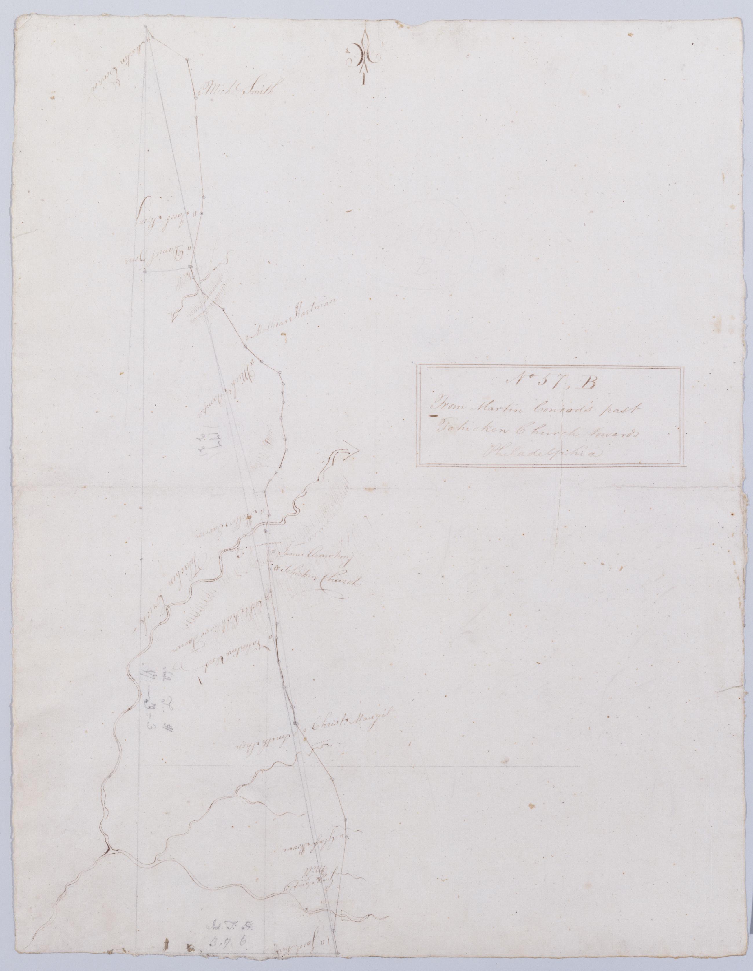
Cartographic From Martin Conrod's past Tohicken Church towards Philadelphia. No 57, B / by Robert Erskine F.R.S. Geogr. A. U.S. and Assistants. Foxed, creased and abraded. Mounted on cloth, bound and cropped, disbound and silked by subsequent owners. Cleaned after removal of backings 1999; some fill remains. Sheathed in mylar. In pencil on recto: "57 B". In pencil on verso: "B". Military topographic map. Covers Bucks County, Pennsylvania. Shows roads running through Strawntown, Keelersville and Hagersville. Also shows buildings and owners' names, landforms and streams. Pen-and-ink, pencil on laid paper. Shows relief by hachures. Title proper from recto is the work of a later editor--Simeon DeWitt or his assign--subsequent to 1820. View Item
Cartographic From Bethlehem to Broad Axe. No 58 / by Robert Erskine F.R.S. Geogr. A. U.S. and Assistants. In ink on verso: "No 58" (partly damaged by cropping). In pencil on recto: "58". Military topographic map. Covers Northhampton, Bucks and Montgomery counties, Pennsylvania. Shows roads running through Bethlehem, Hellertown, Pleasant Valley, Strawntown, Keelersville, Hagersville, Doyles Corner, Trewigtown, Montgomeryville, Spring House, Ambler and Fort Washington. Also shows buildings and owners' names, landforms and streams. Pen-and-ink, pencil on laid paper. Shows relief by hachures. Stained, foxed and abraded. Mounted on cloth, bound and cropped, disbound and silked by subsequent owners. View Item
Cartographic Road from Leahi Ferry towards Philadelphia. No 57, A / by Robert Erskine F.R.S. Geogr. A. U.S. and Assistants. In pencil on recto: "57 A". Military topographic map. Covers Northhampton and Bucks counties, Pennsylvania. Shows roads running through Bethlehem, Hellertown and Pleasant Valley. Also shows buildings and owners' names, landforms and streams. Pen-and-ink, pencil on laid paper. Shows relief by hachures. Soiled, creased and abraded. Mounted on cloth, bound and cropped, disbound and silked by subsequent owners. Cleaned after removal of backings 1999; some fill remains. Sheathed in mylar. Title proper from recto is the work of a later editor--Simeon DeWitt or his assign--subsequent to 1820. View Item
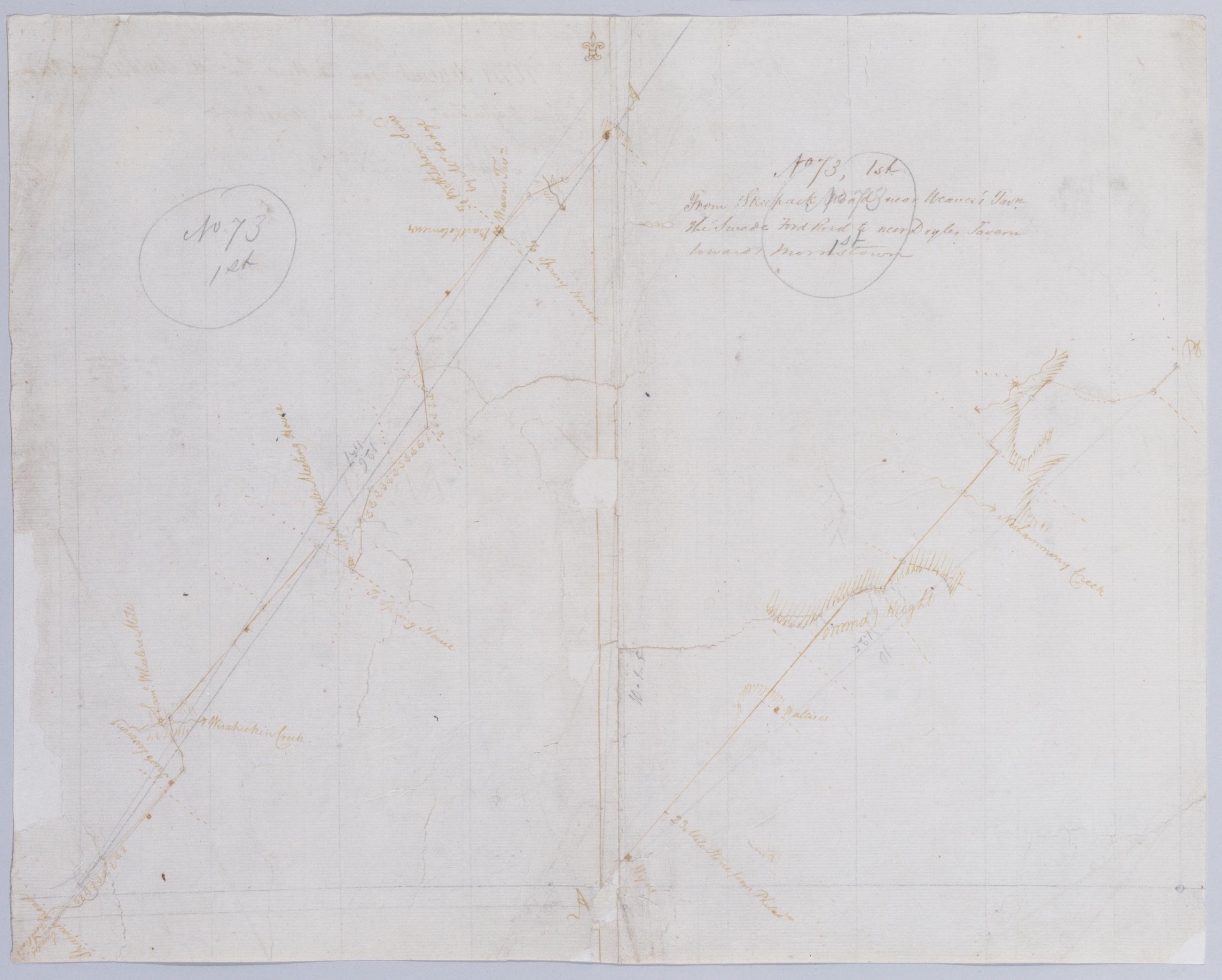
Cartographic From Skeepack Road near Weaver's Tavn. the Swede Ford Road to near Doyles Tavern towards Morristown. No 73, 1st / by Robert Erskine F.R.S. Geogr. A. U.S. and Assistants. Creased, torn, frayed and abraded. Mounted on cloth, bound and cropped, disbound and silked by subsequent owners. Cleaned after removal of backings 1999; some fill remains. Sheathed in mylar. Imperfect: lacking 2 x 2 cm. at center. In pencil on recto: "No 73 1st" (twice). Military topographic map. Covers Bucks and Montgomery counties, Pennsylvania. Shows roads running through Norristown, North Wales, New Britain and Doylestown. Also shows buildings and owners' names, landforms and streams. Pen-and-ink, pencil on laid paper. Shows relief by hachures. View Item
Cartographic Road from Trenton Ferry to Bristol. No 87, C / by Robert Erskine F.R.S. Geogr. A. U.S. and Assistants. In pencil on recto: "No 87 C". Military topographic map. Covers the townships of Falls and Bristol in Bucks County, Pennsylvania. Shows roads running from Trenton, New Jersey, through Morrisville, Wheat Sheaf, Tullytown and Bristol, Pennsylvania. Also shows buildings and owners' names, landforms and streams. Pen-and-ink, pencil on laid paper. Shows relief by hachures. Soiled, foxed, creased, frayed and abraded. Mounted on cloth, bound, disbound and silked by subsequent owners. Cleaned after removal of backings 1999; some fill remains. Sheathed in mylar. Title proper also in ink on verso. View Item
Cartographic Crossing Correll's Ferry towards Morristown to Ringoe's Tavern. No 73 - 3rd / by Robert Erskine F.R.S. Geogr. A. U.S. and Assistants. Heavily soiled, creased and abraded. Mounted on cloth, bound and cropped, disbound and silked by subsequent owners. Cleaned after removal of backings 1999; some fill remains. Sheathed in mylar. In pencil on recto: "No 73 3rd". Military topographic map. Covers the townships of Solebury in Bucks County, Pennsylvania, and of Delaware and West Amwell in Hunterdon County, New Jersey. Shows roads running through Deer Park and New Hope in Pennsylvania; Lambertville, Mount Airy and Ringoes in New Jersey. Also shows buildings and owners' names, landforms and streams. Pen-and-ink, pencil on laid paper. View Item
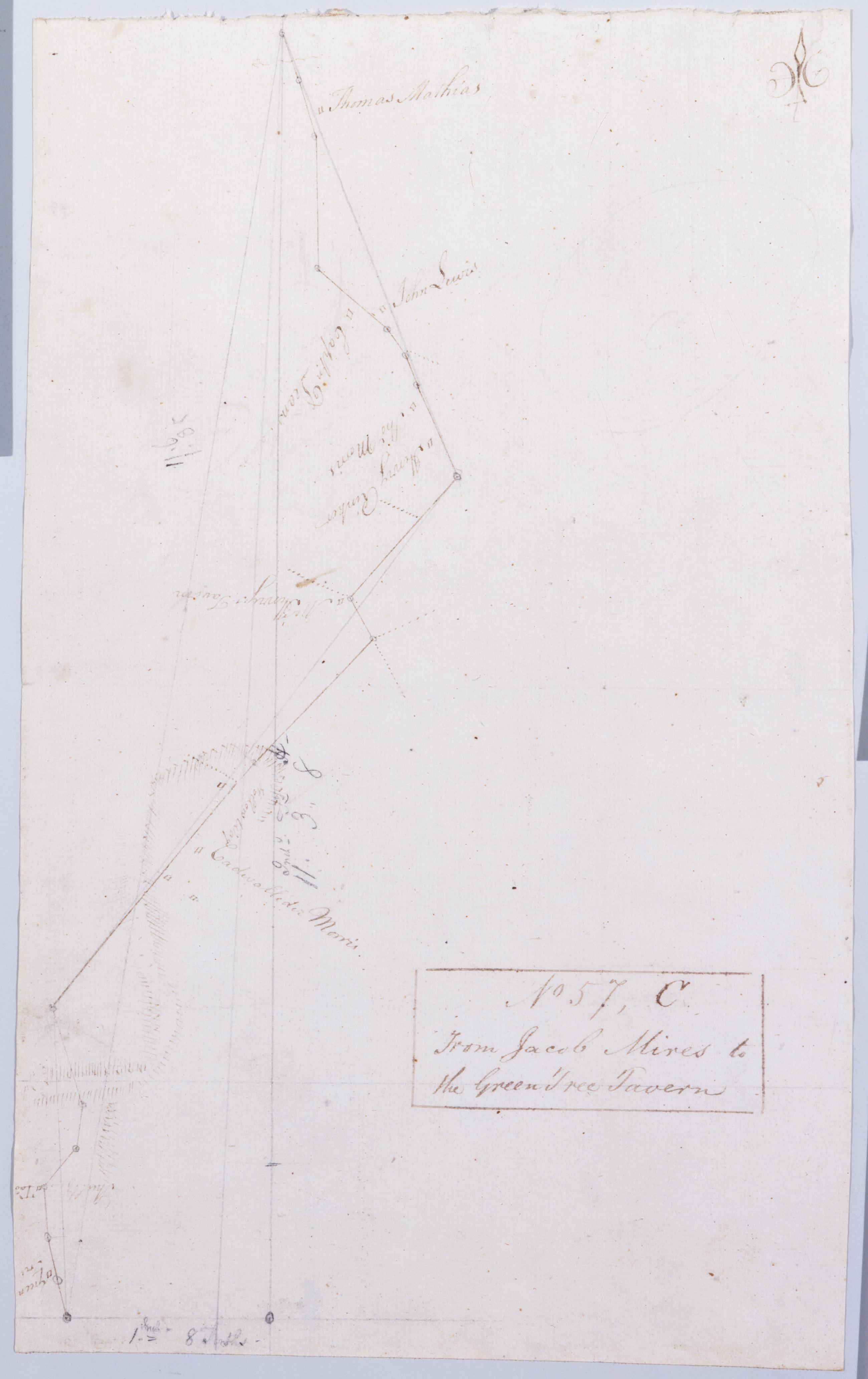
Cartographic From Jacob Mires to the Green Tree Tavern. No 57, C / by Robert Erskine F.R.S. Geogr. A. U.S. and Assistants. Also in ink on verso: "Monmouth Court House". Foxed, creased and abraded. Mounted on cloth, bound and cropped, disbound and silked by subsequent owners. Cleaned after removal of backings 1999; some fill remains. Sheathed in mylar. In pencil on recto: "57 C". Military topographic map. Covers Bucks and Montgomery counties, Pennsylvania. Shows roads running through Doyles Corner. Also shows buildings and owners' names, landforms and streams. Pen-and-ink, pencil on laid paper. Shows relief by hachures. View Item
Cartographic Road from Bristol to Kingsington. No 87 D / by Robert Erskine F.R.S. Geogr. A. U.S. and Assistants. In pencil on recto: "No 87 D". Military topographic map. Covers the city of Philadelphia and the townships of Bristol and Bensalem in Bucks County- Pennsylvania. Shows roads running through Bristol- Eddington- Maud- Andalusia- Holmesburg and Frankford- now in Philadelphia. Also shows buildings and owners' names- landforms and streams. Pen-and-ink- pencil on laid paper. Shows relief by hachures. Soiled- creased- torn- frayed and abraded. Mounted on cloth- cropped- bound- disbound and silked by subsequent owners. Cleaned after removal of backings 1999; some fill remains. Lined with China paper. View Item
Cartographic From near Doyles Tavern Swedes Ford Road into the old York Road + along it towards Morristown. No 73 2nd / by Robert Erskine F.R.S. Geogr. A. U.S. and Assistants. Creased- torn- frayed and abraded. Mounted on cloth- bound and cropped- disbound and silked by subsequent owners. Cleaned after removal of backings 1999; some fill remains. Sheathed in mylar. Military topographic map. Covers Bucks County- Pennsylvania. Shows roads running through Doylestown- Buckingham and Lahaska. Also shows buildings and owners' names- landforms and streams. Pen-and-ink- pencil on laid paper. Shows relief by hachures. Title proper from recto is the work of a later editor--Simeon DeWitt or his assign--subsequent to 1820. View Item
Cartographic From Martin Conrod's past Tohicken Church towards Philadelphia. No 57 B / by Robert Erskine F.R.S. Geogr. A. U.S. and Assistants. Foxed- creased and abraded. Mounted on cloth- bound and cropped- disbound and silked by subsequent owners. Cleaned after removal of backings 1999; some fill remains. Sheathed in mylar. In pencil on recto: "57 B". In pencil on verso: "B". Military topographic map. Covers Bucks County- Pennsylvania. Shows roads running through Strawntown- Keelersville and Hagersville. Also shows buildings and owners' names- landforms and streams. Pen-and-ink- pencil on laid paper. Shows relief by hachures. Title proper from recto is the work of a later editor--Simeon DeWitt or his assign--subsequent to 1820. View Item
Cartographic From Bethlehem to Broad Axe. No 58 / by Robert Erskine F.R.S. Geogr. A. U.S. and Assistants. In ink on verso: "No 58" (partly damaged by cropping). In pencil on recto: "58". Military topographic map. Covers Northhampton- Bucks and Montgomery counties- Pennsylvania. Shows roads running through Bethlehem- Hellertown- Pleasant Valley- Strawntown- Keelersville- Hagersville- Doyles Corner- Trewigtown- Montgomeryville- Spring House- Ambler and Fort Washington. Also shows buildings and owners' names- landforms and streams. Pen-and-ink- pencil on laid paper. Shows relief by hachures. Stained- foxed and abraded. Mounted on cloth- bound and cropped- disbound and silked by subsequent owners. View Item
Cartographic Road from Leahi Ferry towards Philadelphia. No 57 A / by Robert Erskine F.R.S. Geogr. A. U.S. and Assistants. In pencil on recto: "57 A". Military topographic map. Covers Northhampton and Bucks counties- Pennsylvania. Shows roads running through Bethlehem- Hellertown and Pleasant Valley. Also shows buildings and owners' names- landforms and streams. Pen-and-ink- pencil on laid paper. Shows relief by hachures. Soiled- creased and abraded. Mounted on cloth- bound and cropped- disbound and silked by subsequent owners. Cleaned after removal of backings 1999; some fill remains. Sheathed in mylar. Title proper from recto is the work of a later editor--Simeon DeWitt or his assign--subsequent to 1820. View Item
Cartographic From Skeepack Road near Weaver's Tavn. the Swede Ford Road to near Doyles Tavern towards Morristown. No 73 1st / by Robert Erskine F.R.S. Geogr. A. U.S. and Assistants. Creased- torn- frayed and abraded. Mounted on cloth- bound and cropped- disbound and silked by subsequent owners. Cleaned after removal of backings 1999; some fill remains. Sheathed in mylar. Imperfect: lacking 2 x 2 cm. at center. In pencil on recto: "No 73 1st" (twice). Military topographic map. Covers Bucks and Montgomery counties- Pennsylvania. Shows roads running through Norristown- North Wales- New Britain and Doylestown. Also shows buildings and owners' names- landforms and streams. Pen-and-ink- pencil on laid paper. Shows relief by hachures. View Item
Cartographic Road from Trenton Ferry to Bristol. No 87 C / by Robert Erskine F.R.S. Geogr. A. U.S. and Assistants. In pencil on recto: "No 87 C". Military topographic map. Covers the townships of Falls and Bristol in Bucks County- Pennsylvania. Shows roads running from Trenton- New Jersey- through Morrisville- Wheat Sheaf- Tullytown and Bristol- Pennsylvania. Also shows buildings and owners' names- landforms and streams. Pen-and-ink- pencil on laid paper. Shows relief by hachures. Soiled- foxed- creased- frayed and abraded. Mounted on cloth- bound- disbound and silked by subsequent owners. Cleaned after removal of backings 1999; some fill remains. Sheathed in mylar. Title proper also in ink on verso. View Item
Cartographic Crossing Correll's Ferry towards Morristown to Ringoe's Tavern. No 73 - 3rd / by Robert Erskine F.R.S. Geogr. A. U.S. and Assistants. Heavily soiled- creased and abraded. Mounted on cloth- bound and cropped- disbound and silked by subsequent owners. Cleaned after removal of backings 1999; some fill remains. Sheathed in mylar. In pencil on recto: "No 73 3rd". Military topographic map. Covers the townships of Solebury in Bucks County- Pennsylvania- and of Delaware and West Amwell in Hunterdon County- New Jersey. Shows roads running through Deer Park and New Hope in Pennsylvania; Lambertville- Mount Airy and Ringoes in New Jersey. Also shows buildings and owners' names- landforms and streams. Pen-and-ink- pencil on laid paper. View Item
Cartographic From Jacob Mires to the Green Tree Tavern. No 57 C / by Robert Erskine F.R.S. Geogr. A. U.S. and Assistants. Also in ink on verso: "Monmouth Court House". Foxed- creased and abraded. Mounted on cloth- bound and cropped- disbound and silked by subsequent owners. Cleaned after removal of backings 1999; some fill remains. Sheathed in mylar. In pencil on recto: "57 C". Military topographic map. Covers Bucks and Montgomery counties- Pennsylvania. Shows roads running through Doyles Corner. Also shows buildings and owners' names- landforms and streams. Pen-and-ink- pencil on laid paper. Shows relief by hachures. View Item