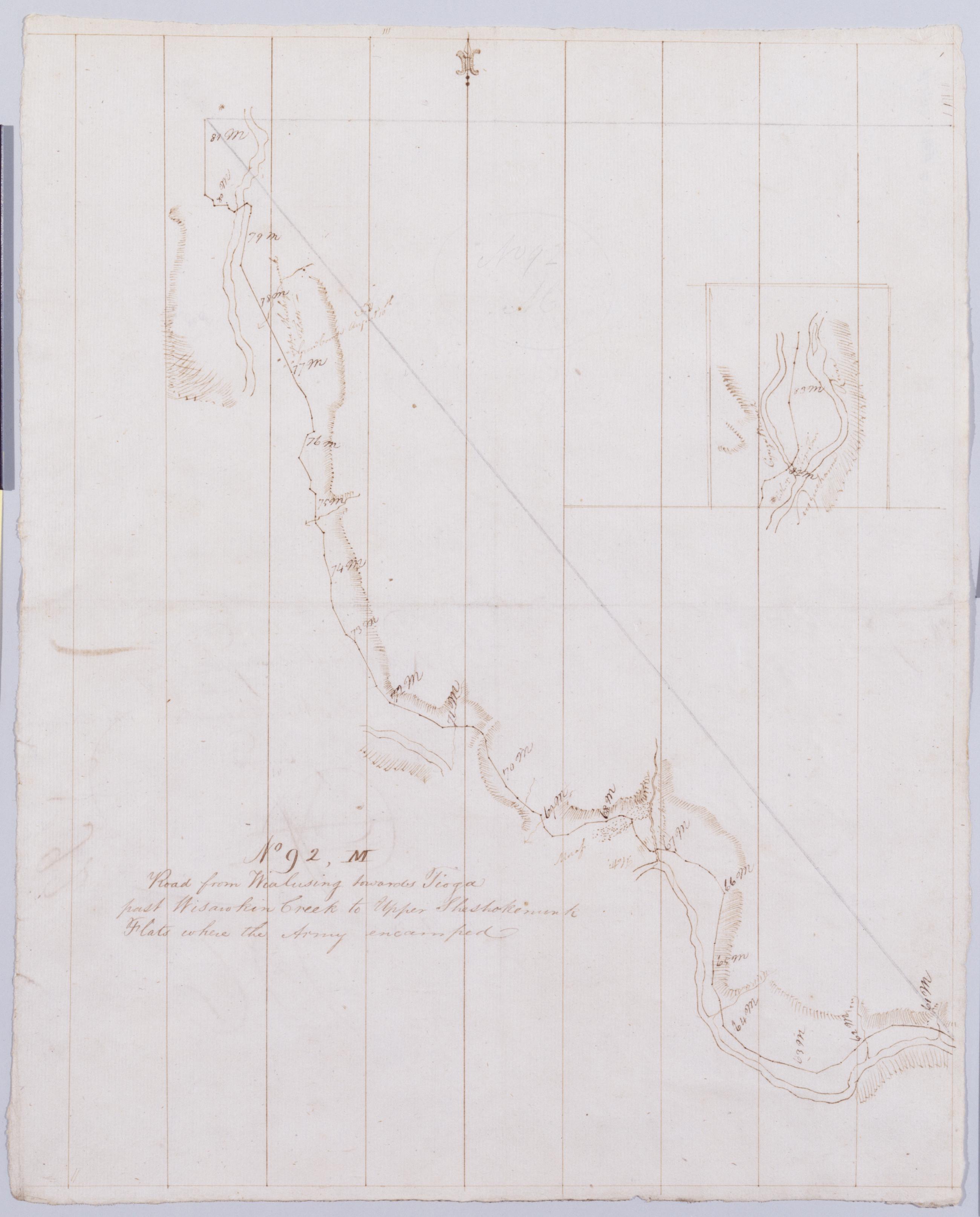
Cartographic Road from Wialusing towards Tioga past Wisawkin Creek to Upper Sheshokenunk Flats where the Army encamped. No 92, M / by Robert Erskine F.R.S. Geogr. A. U.S. and Assistants. Creased, soiled and abraded. Mounted on cloth, bound, disbound and silked by subsequent owners. Cleaned after removal of backings 1999; some fill remains. Sheathed in mylar. In erased pencil on recto: "No 92 M". Inset is northernmost extension of main map. Military topographic map. Covers Bradford County, Pennsylvania. Shows roads running through Sayre and East Athens. Also shows buildings and owners' names, landforms and streams. Number accompanying verso title written in different ink. Letter D accompanying verso title crossed out using ink and replaced by M. View Item
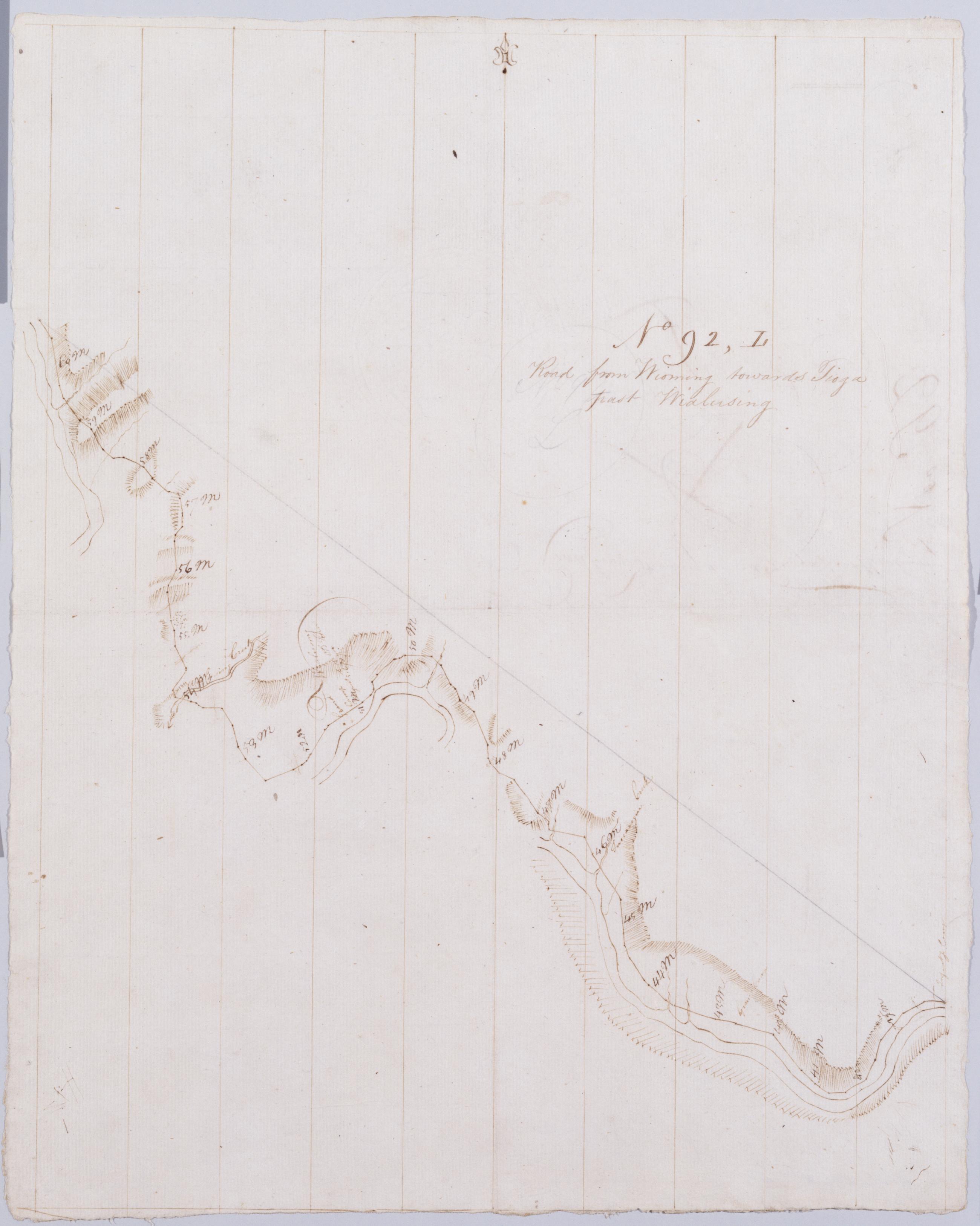
Cartographic Road from Wioming towards Tioga past Wialusing. No 92, L / by Robert Erskine F.R.S. Geogr. A. U.S. and Assistants. Creased, foxed, soiled and abraded. Mounted on cloth, bound, disbound and silked by subsequent owners. Cleaned after removal of backings 1999; some fill remains. Sheathed in mylar. In erased pencil on recto: "No 92 L". Military topographic map. Covers the counties of Wyoming and Bradford, Pennsylvania. Shows roads running through Wyalusing and Rummerfield. Also shows buildings and owners' names, landforms and streams. Number accompanying verso title written in different ink. Letter C accompanying verso title crossed out using ink and replaced by L. View Item
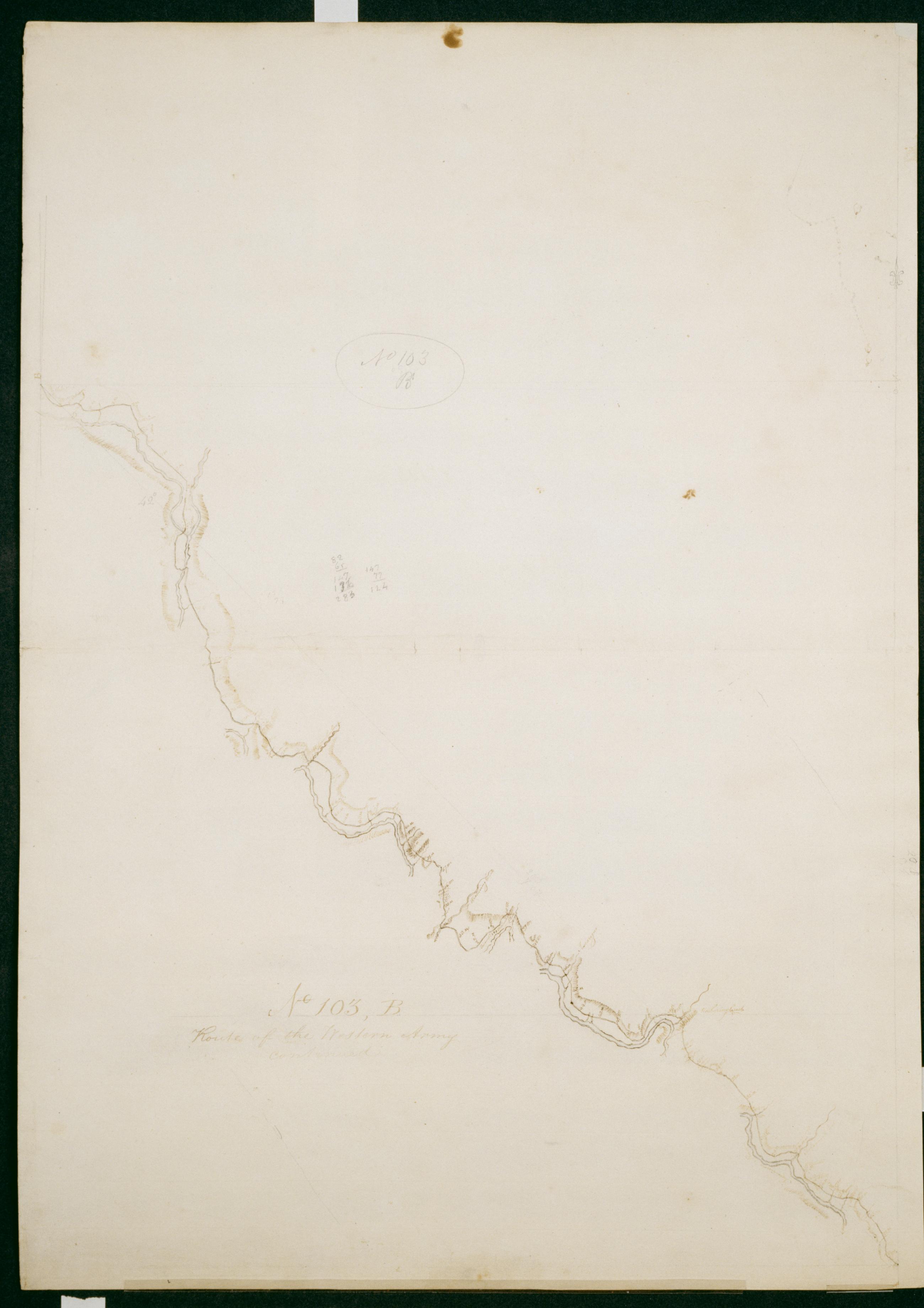
Cartographic Route of the Western Army continued. No. 103, B / by Lt. Lodge ; by Robert Erskine F.R.S. Geogr. A. U.S. and Assistants. Creased, soiled, stained and abraded. Mounted on cloth, bound and cropped, disbound and silked by subsequent owners. Cleaned after removal of backings 1999; some fill remains. Sheathed in mylar. In ink on verso "B No. 103-". In pencil on recto: "No 103 B". Military topographic map. Covers the counties of Wyoming and Bradford in Pennsylvania and of Chemung in New York. Also shows landforms and streams. Pen-and-ink, pencil on laid paper. Shows relief by hachures. Title proper from recto is the work of a later editor--Simeon DeWitt or his assign--subsequent to 1820. View Item
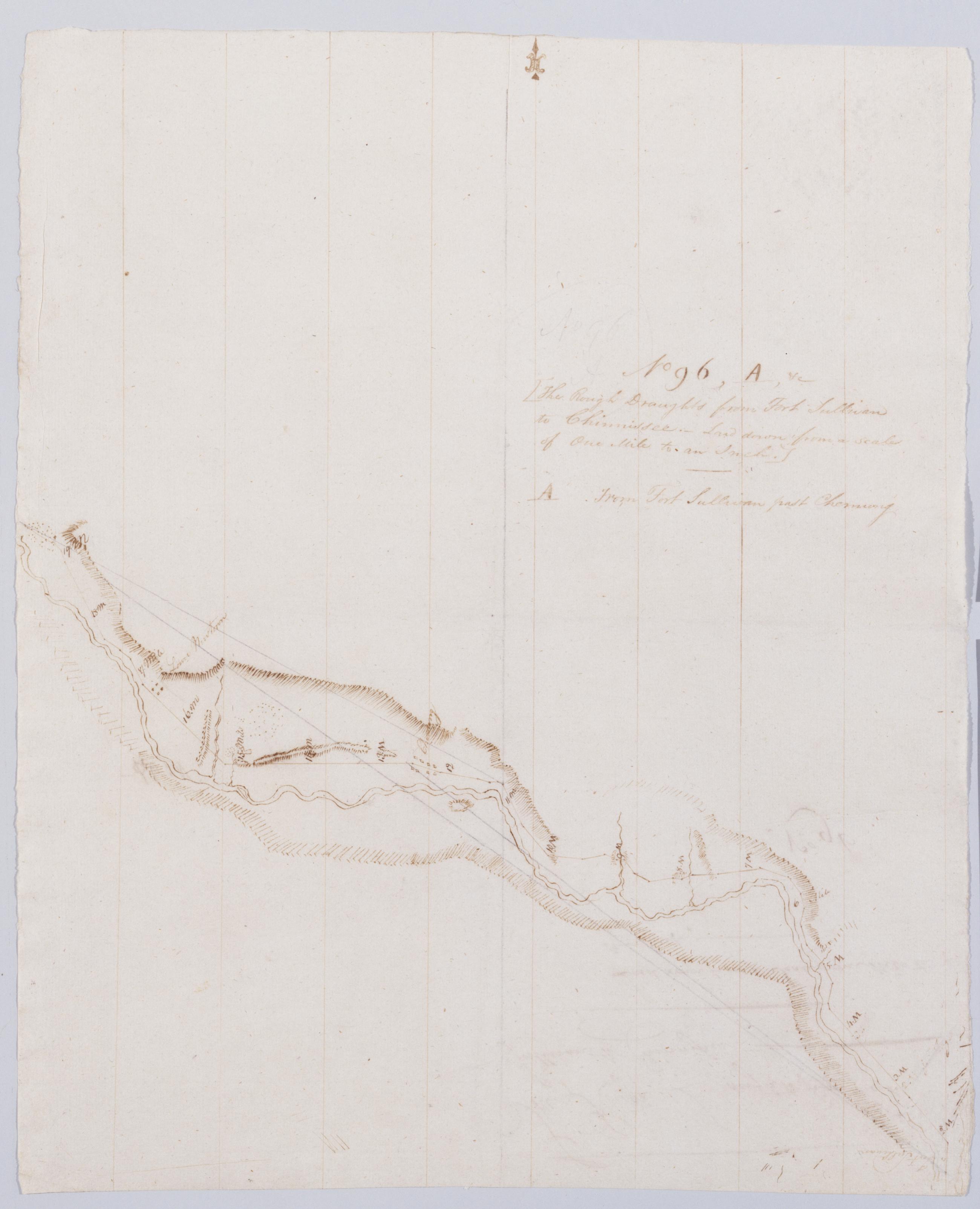
Cartographic From Fort Sullivan past Chemung. No 96, A / by Robert Erskine F.R.S. Geogr. A. U.S. and Assistants. Abraded. Mounted on cloth, bound, disbound and silked by subsequent owners. Cleaned after removal of backings 1999; some fill remains. Sheathed in mylar. In pencil on recto, "No 96 A". Military topographic map. Covers the towns of Ashland and Elmira in Chemung County, New York, and also part of Bradford County, Pennsylvania. Shows roads running through Waverly, Chemung and Wellsburg. Also shows landforms and streams. Pen-and-ink, pencil on laid paper. Scale statement from verso of this sheet. Shows relief by hachures. View Item
Cartographic Road from Wialusing towards Tioga past Wisawkin Creek to Upper Sheshokenunk Flats where the Army encamped. No 92 M / by Robert Erskine F.R.S. Geogr. A. U.S. and Assistants. Creased- soiled and abraded. Mounted on cloth- bound- disbound and silked by subsequent owners. Cleaned after removal of backings 1999; some fill remains. Sheathed in mylar. In erased pencil on recto: "No 92 M". Inset is northernmost extension of main map. Military topographic map. Covers Bradford County- Pennsylvania. Shows roads running through Sayre and East Athens. Also shows buildings and owners' names- landforms and streams. Number accompanying verso title written in different ink. Letter D accompanying verso title crossed out using ink and replaced by M. View Item
Cartographic Road from Wioming towards Tioga past Wialusing. No 92 L / by Robert Erskine F.R.S. Geogr. A. U.S. and Assistants. Creased- foxed- soiled and abraded. Mounted on cloth- bound- disbound and silked by subsequent owners. Cleaned after removal of backings 1999; some fill remains. Sheathed in mylar. In erased pencil on recto: "No 92 L". Military topographic map. Covers the counties of Wyoming and Bradford- Pennsylvania. Shows roads running through Wyalusing and Rummerfield. Also shows buildings and owners' names- landforms and streams. Number accompanying verso title written in different ink. Letter C accompanying verso title crossed out using ink and replaced by L. View Item
Cartographic Route of the Western Army continued. No. 103 B / by Lt. Lodge ; by Robert Erskine F.R.S. Geogr. A. U.S. and Assistants. Creased- soiled- stained and abraded. Mounted on cloth- bound and cropped- disbound and silked by subsequent owners. Cleaned after removal of backings 1999; some fill remains. Sheathed in mylar. In ink on verso "B No. 103-". In pencil on recto: "No 103 B". Military topographic map. Covers the counties of Wyoming and Bradford in Pennsylvania and of Chemung in New York. Also shows landforms and streams. Pen-and-ink- pencil on laid paper. Shows relief by hachures. Title proper from recto is the work of a later editor--Simeon DeWitt or his assign--subsequent to 1820. View Item
Cartographic From Fort Sullivan past Chemung. No 96 A / by Robert Erskine F.R.S. Geogr. A. U.S. and Assistants. Abraded. Mounted on cloth- bound- disbound and silked by subsequent owners. Cleaned after removal of backings 1999; some fill remains. Sheathed in mylar. In pencil on recto- "No 96 A". Military topographic map. Covers the towns of Ashland and Elmira in Chemung County- New York- and also part of Bradford County- Pennsylvania. Shows roads running through Waverly- Chemung and Wellsburg. Also shows landforms and streams. Pen-and-ink- pencil on laid paper. Scale statement from verso of this sheet. Shows relief by hachures. View Item