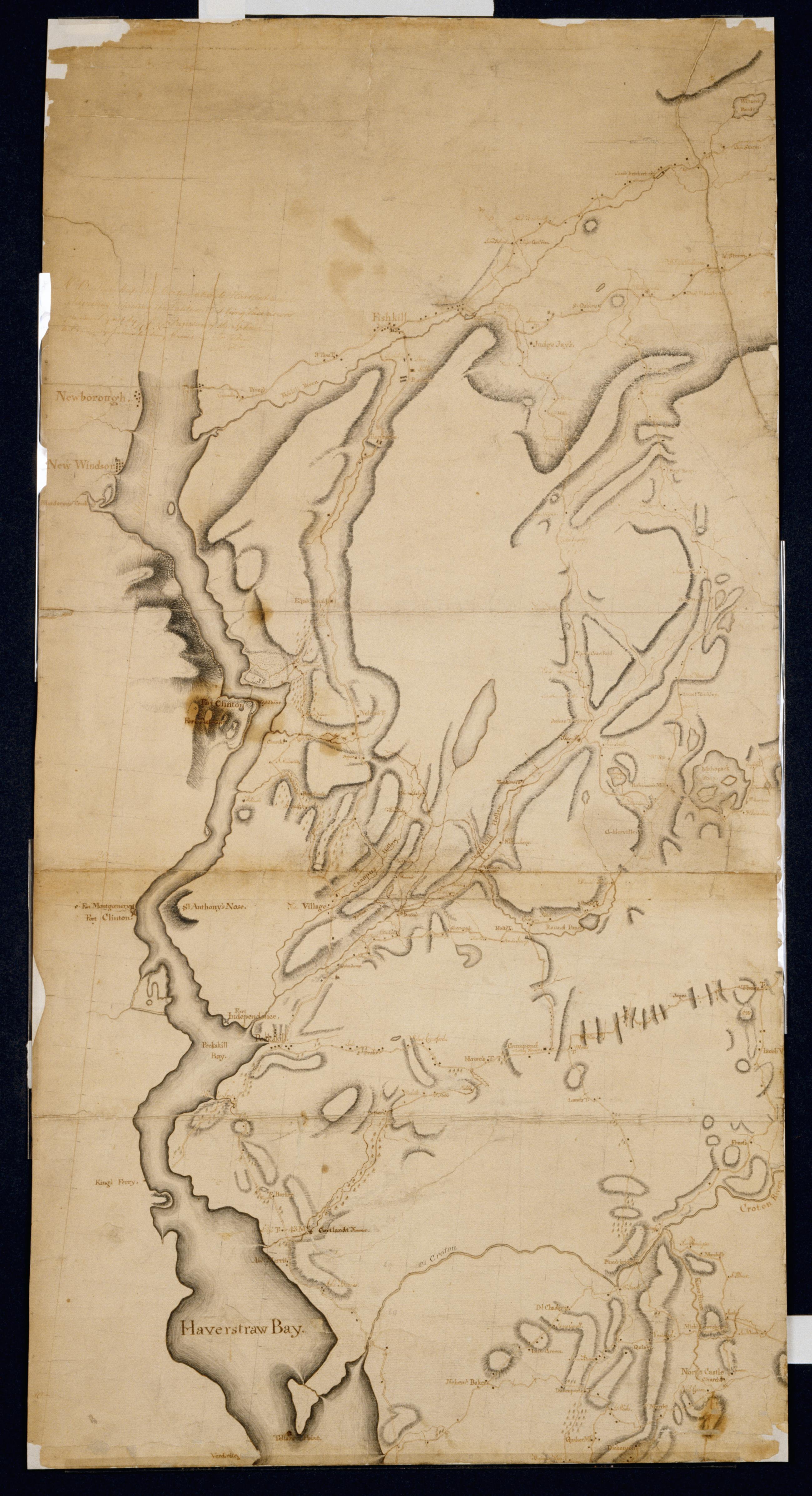
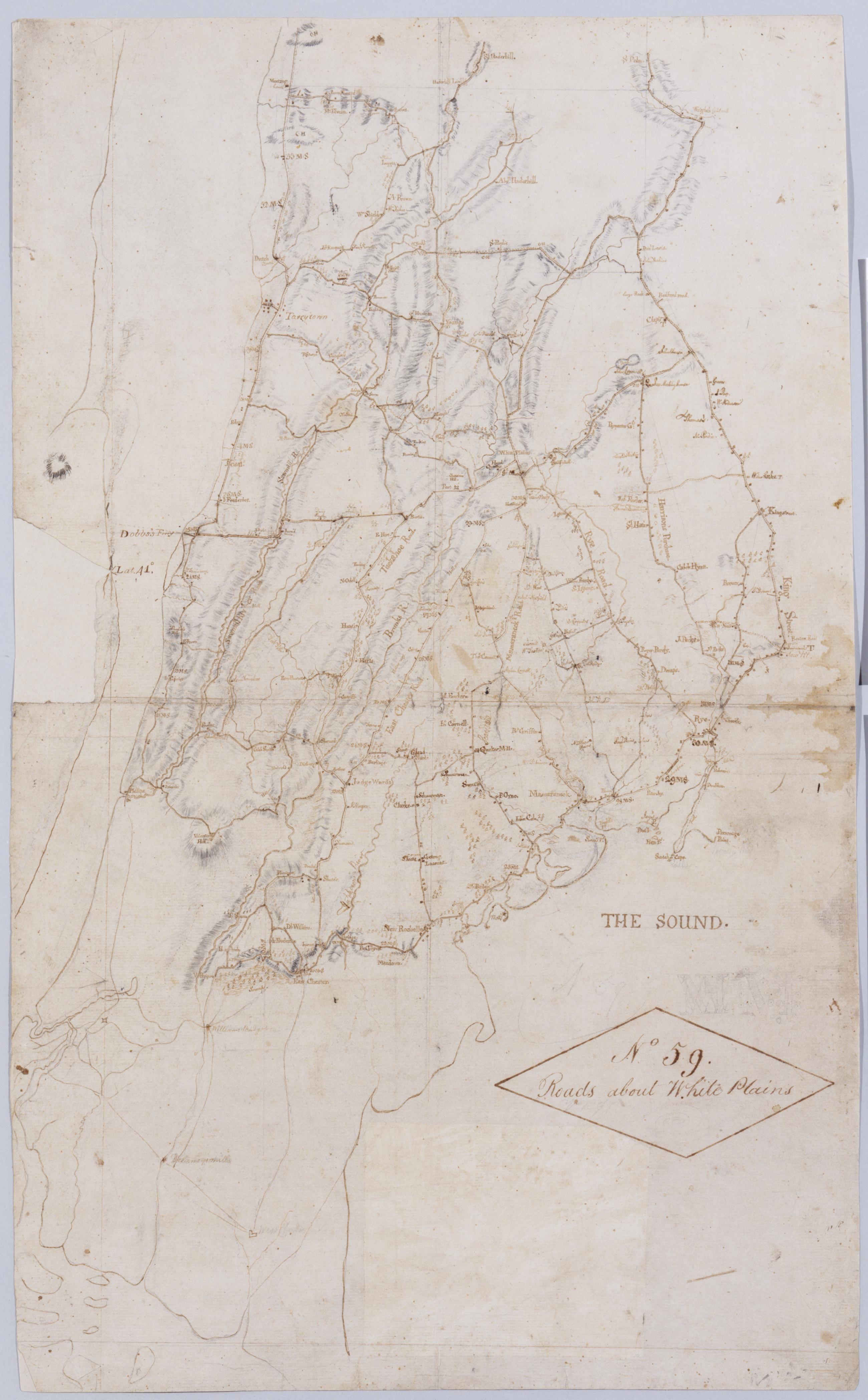
Cartographic Roads about White Plains. No 59 / by Robert Erskine F.R.S. Geogr. A. U.S. and Assistants. A variant of the title given by Guthorn: appears on map No. 120 of the series which, as soiling shows, was once pasted above the lower margin of this map, no. 59. In ink on verso: "No. 59 Joined to No. 25. 32 & 60." There is no evidence that these sheets were ever physically joined, although nos. 25 and 32 do cover adjacent areas. (Map no. 25 is missing.) No. 60 is a copy of this map, no. 59. Military topographic map. Covers most of Westchester County, New York and western Fairfield County, Connecticut; also covers northern New York City. View Item
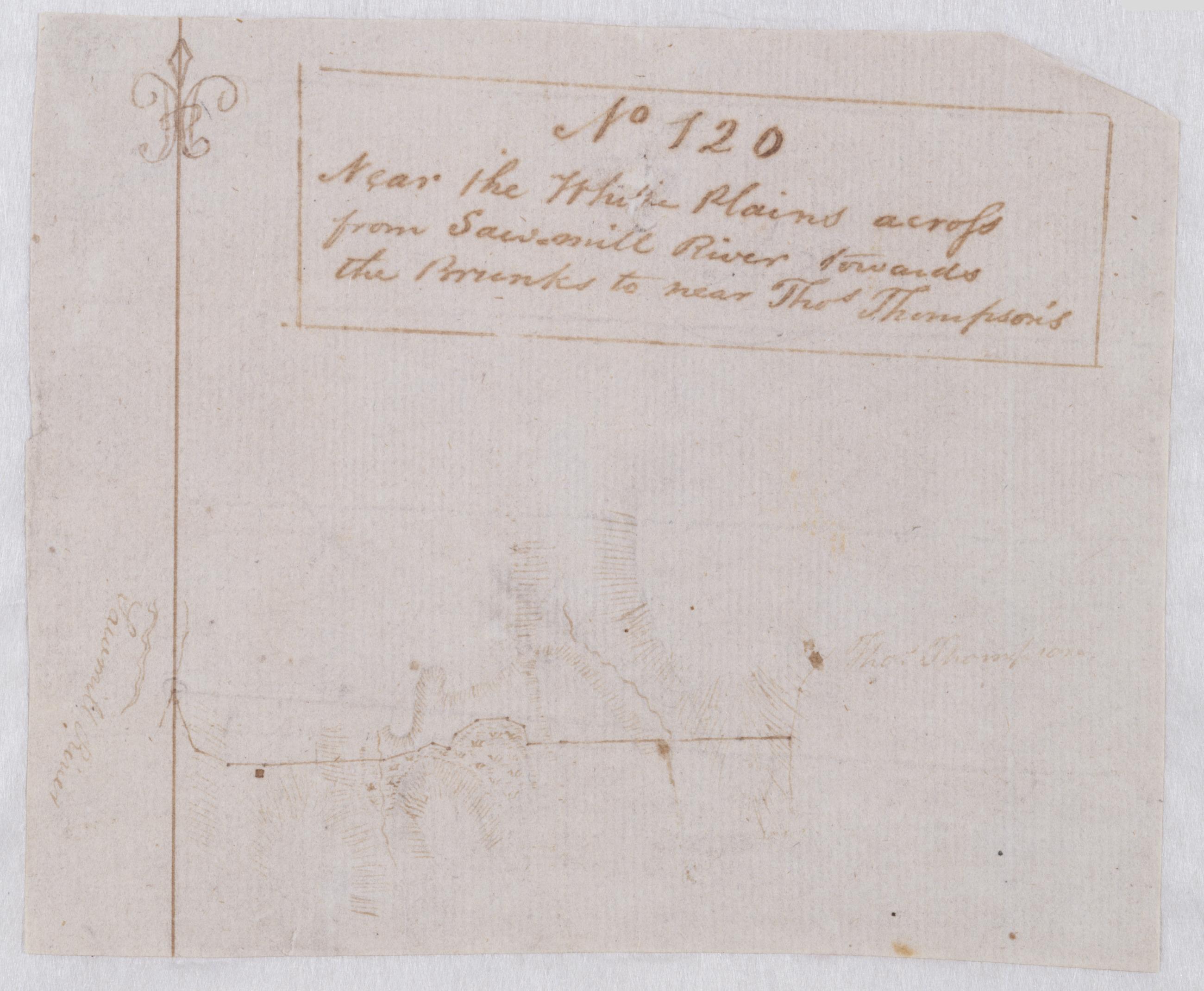
Cartographic Near the White Plains across from Sawmill River towards the Brunks to near Thos. Thompson's. No 120 / by Robert Erskine F.R.S. Geogr. A. U.S. and Assistants. Foxed and severely abraded. Cropped. For a time pasted above the lower margin of map No. 59 in series. Cleaned after removal of backings 1999; some fill remains. Sheathed in mylar. Military topographic map covering an area in Westchester County, New York. Probably the road shown as a dotted line on the map titled "A Draught of the Ground between the White Plains and Kingsbridge." This map shows buildings, landforms and streams. Pen-and-ink, pencil on laid paper. Shows relief by hachures. Title proper from recto is the work of a later editor--Simeon DeWitt or his assign--subsequent to 1820. View Item
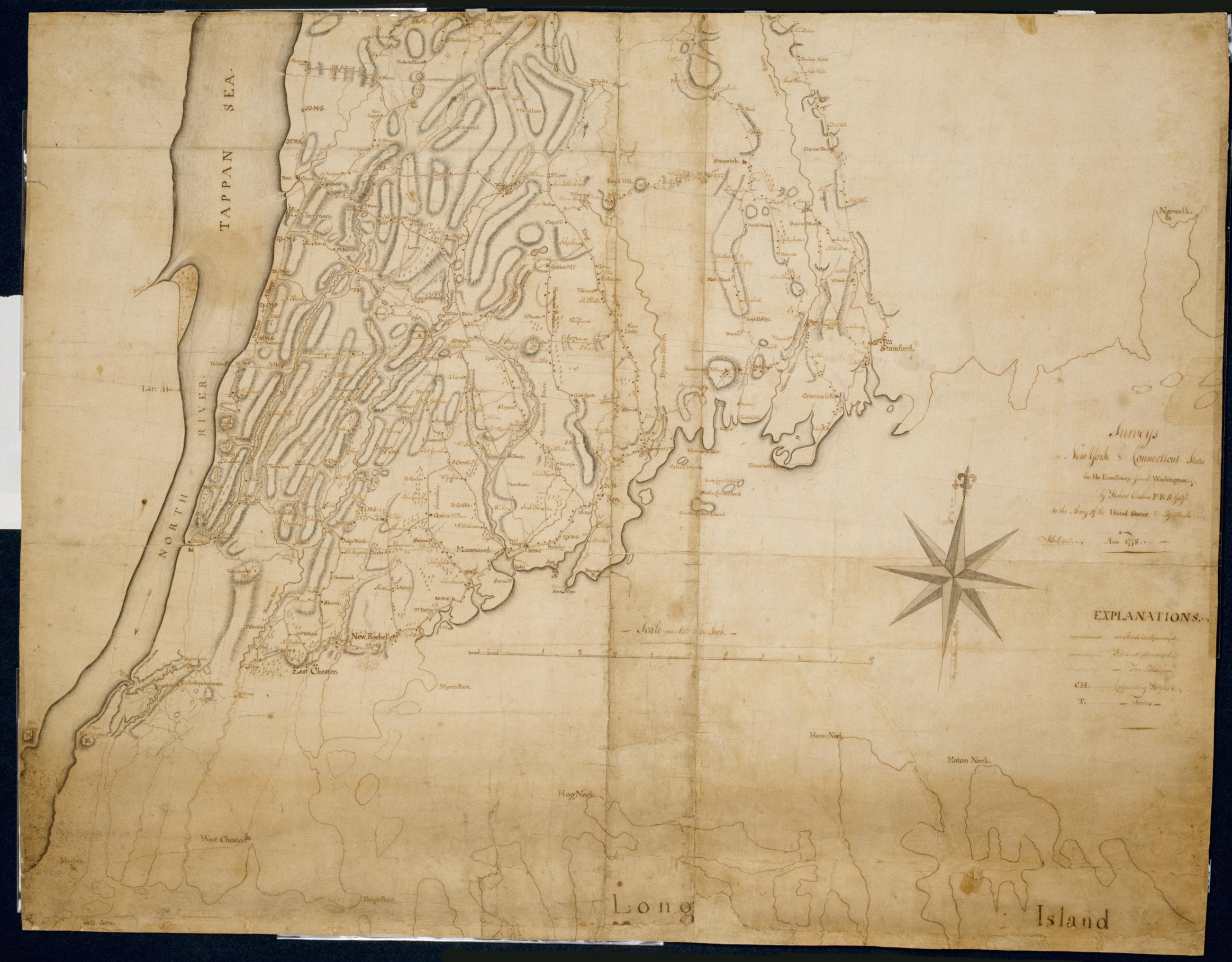
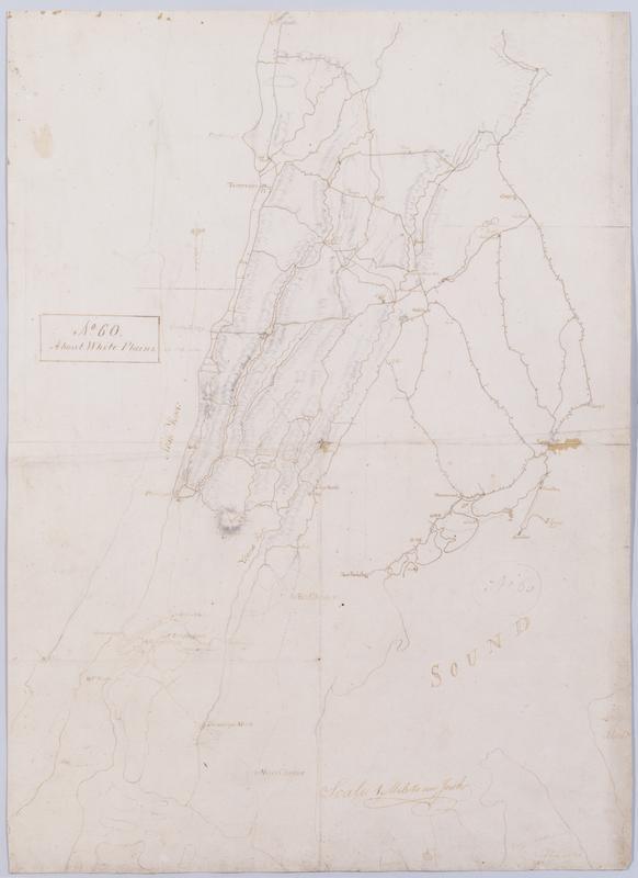
Cartographic About White Plains. No 60 / by Robert Erskine F.R.S. Geogr. A. U.S. and Assistants. In ink on recto: geometrical sketches, "No. 60". In pencil on recto: "No 60". Military topographic map. Covers most of Westchester County, New York and western Fairfield County, Connecticut; also covers northern New York City. Shows roads, buildings and owners' names, also landforms and streams. Pen-and-ink, pencil on laid paper. Shows relief by hachures. Stained, soiled, foxed, creased, frayed and abraded. Mounted on cloth, bound and cropped, disbound and silked by subsequent owners. Cleaned after removal of backings 1999; some fill remains. Sheathed in mylar. View Item
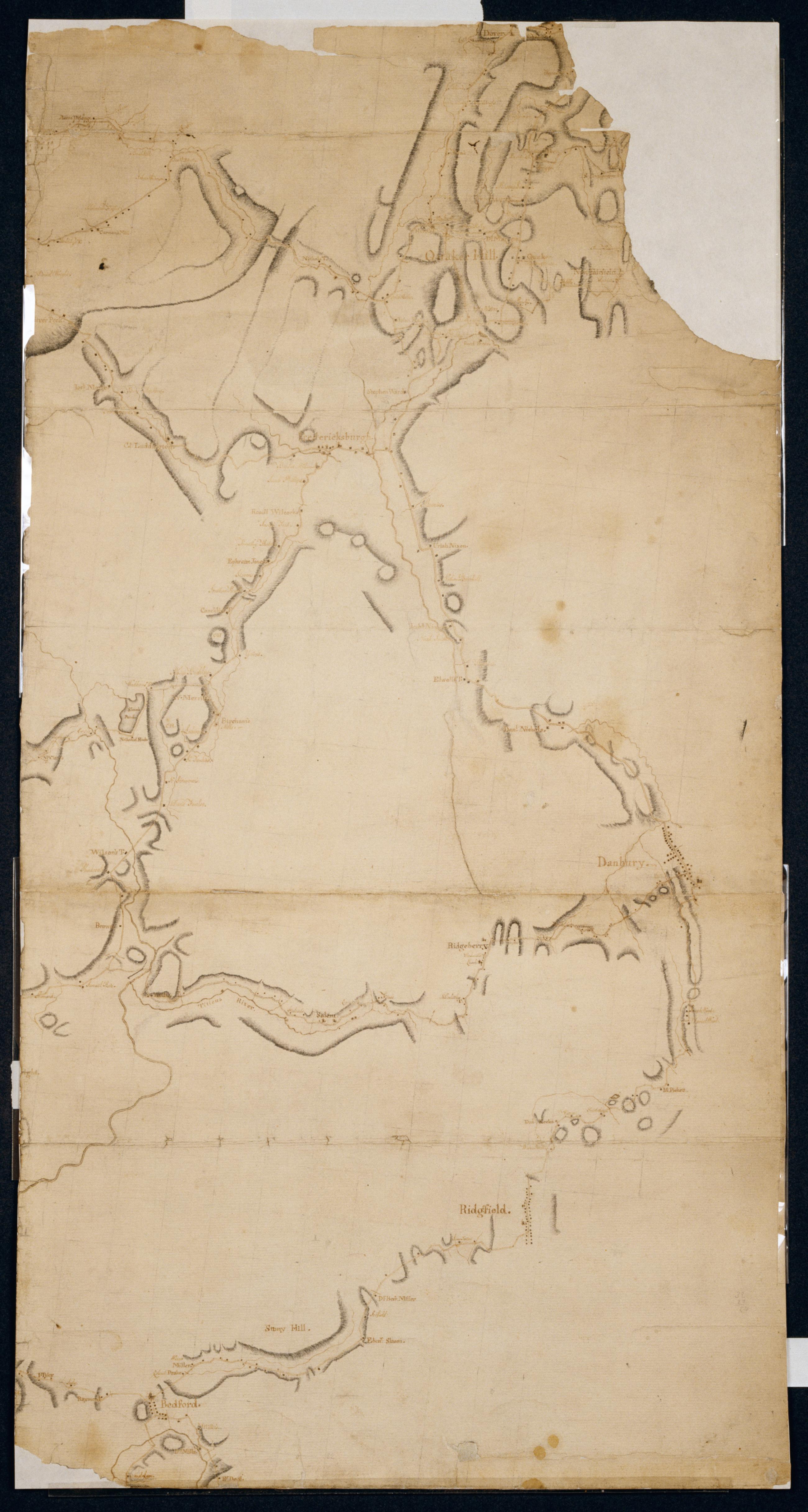
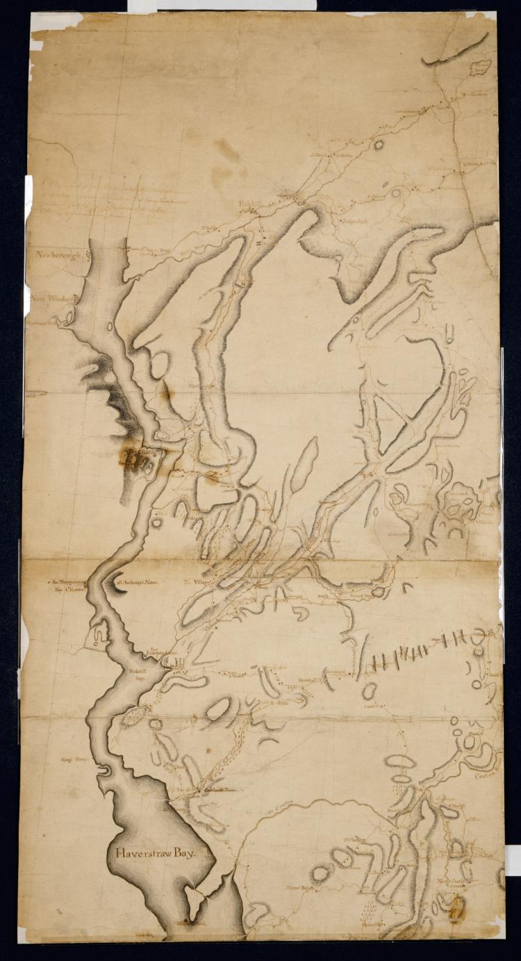
Cartographic Surveys in New York & Connecticut States for His Excellency General Washington : Anno 1778 by Robert Erskine F.R.S. Geogr: to the Army of the United States & Assistants ; W Scull delint., first fragment Has projection grid in faint pencil. Imperfect: lacks 19 x 12 at upper right corner and 3 x 8 cm. at center. Minor losses along frayed top and left edge. Military topographic map; not listed in Heusser nor Guthorn. Covers the counties of Fairfield in Connecticut and of Dutchess, Putnam and Westchester in New York; New York City and the northern shore of Long Island are also shown, but with less detail. Shows some buildings and owners' names, landforms and streams. Pen-and-ink, pencil on laid paper. View Item
Cartographic Surveys in New York & Connecticut States for His Excellency General Washington : Anno 1778 by Robert Erskine F.R.S. Geogr: to the Army of the United States & Assistants ; W Scull delint., third fragment Has projection grid in faint pencil. Imperfect: lacks 19 x 12 at upper right corner and 3 x 8 cm. at center. Minor losses along frayed top and left edge. Military topographic map; not listed in Heusser nor Guthorn. Covers the counties of Fairfield in Connecticut and of Dutchess, Putnam and Westchester in New York; New York City and the northern shore of Long Island are also shown, but with less detail. Shows some buildings and owners' names, landforms and streams. Pen-and-ink, pencil on laid paper. View Item
Cartographic Surveys in New York & Connecticut States for His Excellency General Washington : Anno 1778 by Robert Erskine F.R.S. Geogr: to the Army of the United States & Assistants ; W Scull delint., second fragment Has projection grid in faint pencil. Imperfect: lacks 19 x 12 at upper right corner and 3 x 8 cm. at center. Minor losses along frayed top and left edge. Military topographic map; not listed in Heusser nor Guthorn. Covers the counties of Fairfield in Connecticut and of Dutchess, Putnam and Westchester in New York; New York City and the northern shore of Long Island are also shown, but with less detail. Shows some buildings and owners' names, landforms and streams. Pen-and-ink, pencil on laid paper. View Item
Image Cartographic 3 Items Surveys in New York & Connecticut States for His Excellency General Washington : Anno 1778 by Robert Erskine F.R.S. Geogr: to the Army of the United States & Assistants ; W Scull delint. Has projection grid in faint pencil. Imperfect: lacks 19 x 12 at upper right corner and 3 x 8 cm. at center. Minor losses along frayed top and left edge. Military topographic map; not listed in Heusser nor Guthorn. Covers the counties of Fairfield in Connecticut and of Dutchess, Putnam and Westchester in New York; New York City and the northern shore of Long Island are also shown, but with less detail. Shows some buildings and owners' names, landforms and streams. Pen-and-ink, pencil on laid paper. View Item
Cartographic Roads about White Plains. No 59 / by Robert Erskine F.R.S. Geogr. A. U.S. and Assistants. A variant of the title given by Guthorn: appears on map No. 120 of the series which- as soiling shows- was once pasted above the lower margin of this map- no. 59. In ink on verso: "No. 59 Joined to No. 25. 32 & 60." There is no evidence that these sheets were ever physically joined- although nos. 25 and 32 do cover adjacent areas. (Map no. 25 is missing.) No. 60 is a copy of this map- no. 59. Military topographic map. Covers most of Westchester County- New York and western Fairfield County- Connecticut; also covers northern New York City. View Item
Cartographic Near the White Plains across from Sawmill River towards the Brunks to near Thos. Thompson's. No 120 / by Robert Erskine F.R.S. Geogr. A. U.S. and Assistants. Foxed and severely abraded. Cropped. For a time pasted above the lower margin of map No. 59 in series. Cleaned after removal of backings 1999; some fill remains. Sheathed in mylar. Military topographic map covering an area in Westchester County- New York. Probably the road shown as a dotted line on the map titled "A Draught of the Ground between the White Plains and Kingsbridge." This map shows buildings- landforms and streams. Pen-and-ink- pencil on laid paper. Shows relief by hachures. Title proper from recto is the work of a later editor--Simeon DeWitt or his assign--subsequent to 1820. View Item
Cartographic About White Plains. No 60 / by Robert Erskine F.R.S. Geogr. A. U.S. and Assistants. In ink on recto: geometrical sketches- "No. 60". In pencil on recto: "No 60". Military topographic map. Covers most of Westchester County- New York and western Fairfield County- Connecticut; also covers northern New York City. Shows roads- buildings and owners' names- also landforms and streams. Pen-and-ink- pencil on laid paper. Shows relief by hachures. Stained- soiled- foxed- creased- frayed and abraded. Mounted on cloth- bound and cropped- disbound and silked by subsequent owners. Cleaned after removal of backings 1999; some fill remains. Sheathed in mylar. View Item
Cartographic Surveys in New York & Connecticut States for His Excellency General Washington : Anno 1778 by Robert Erskine F.R.S. Geogr: to the Army of the United States & Assistants ; W Scull delint. Has projection grid in faint pencil. Imperfect: lacks 19 x 12 at upper right corner and 3 x 8 cm. at center. Minor losses along frayed top and left edge. Military topographic map; not listed in Heusser nor Guthorn. Covers the counties of Fairfield in Connecticut and of Dutchess- Putnam and Westchester in New York; New York City and the northern shore of Long Island are also shown- but with less detail. Shows some buildings and owners' names- landforms and streams. Pen-and-ink- pencil on laid paper. View Item