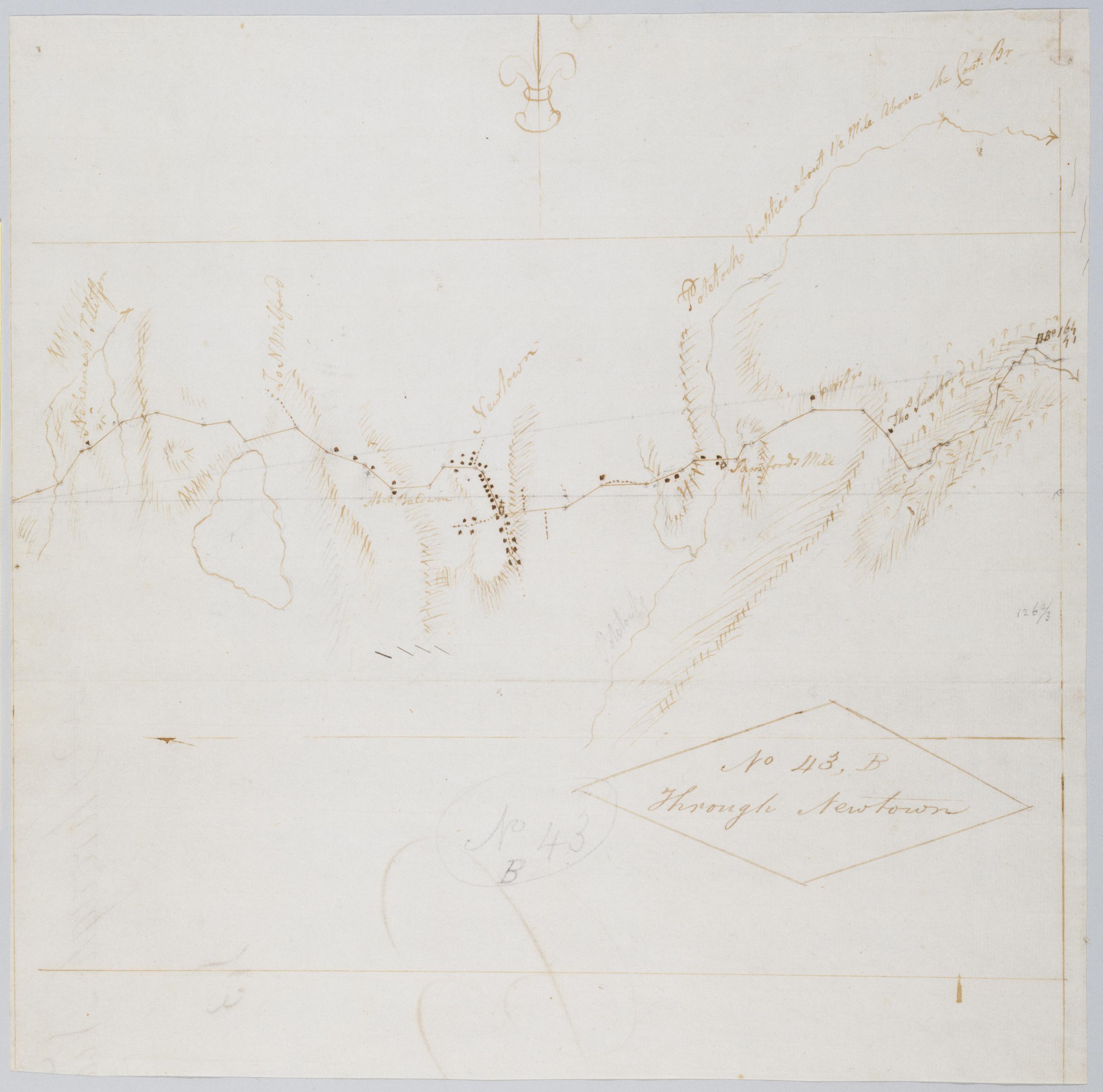
Cartographic Through Newtown. No 43, B / by Robert Erskine F.R.S. Geogr. A. U.S. and Assistants. Foxed, creased, frayed, and abraded. Mounted on cloth, bound and cropped, disbound and silked by subsequent owners. Cleaned after removal of backings 1999; some fill remains. Sheathed in mylar. In pencil on recto: "No 43 B". Military topographic map. Covers the township of Newtown in Fairfield County, Connecticut. Shows roads running through Sandy Hook and Newtown. Also shows buildings and owners' names, landforms and streams. Pen-and-ink, pencil on laid paper. Shows relief by hachures. Title proper from recto is the work of a later editor--Simeon DeWitt or his assign--subsequent to 1820. View Item
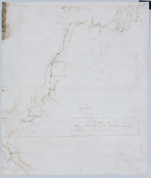
Cartographic From Woodbury to the Continental Bridge, near Newtown. No 43, A / by Robert Erskine F.R.S. Geogr. A. U.S. and Assistants. In pencil on recto: "No 43 A". Military topographic map. Covers the townships of Southbury, Woodbury and Middlebury in New Haven County and of Newtown in Fairfield County, Connecticut. Shows roads running through Woodbury, White Oaks, Southbury, Pomperaug Valley and Bennetts Bridge. Also shows buildings and owners' names, landforms and streams. Pen-and-ink, pencil on laid paper. Shows relief by hachures. Soiled, foxed, creased, frayed, and abraded. Mounted on cloth, bound and cropped, disbound and silked by subsequent owners. Cleaned after removal of backings 1999; some fill remains. View Item
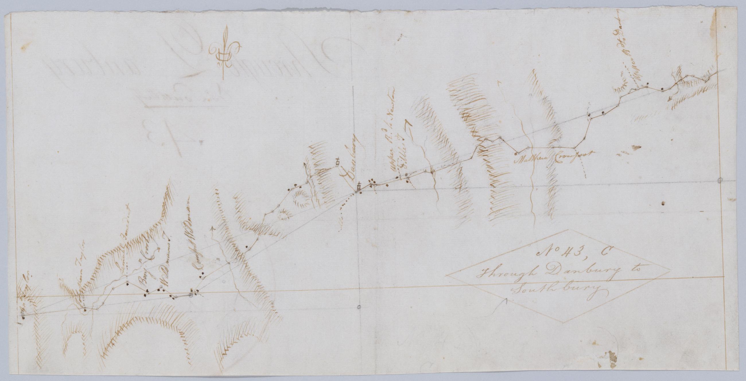
Cartographic Through Danbury to Southbury. No 43, C / by Robert Erskine F.R.S. Geogr. A. U.S. and Assistants. Foxed, creased, frayed, and abraded. Mounted on cloth, bound and cropped, disbound and silked by subsequent owners. Cleaned after removal of backings 1999; some fill remains. Sheathed in mylar. Military topographic map. Covers the townships of Bethel, Danbury and Ridgefield in Fairfield County, Connecticut. Shows roads running through East Danbury and Danbury. Also shows buildings and owners' names, landforms and streams. Pen-and-ink, pencil on laid paper. Shows relief by hachures. Title proper from recto is the work of a later editor--Simeon DeWitt or his assign--subsequent to 1820. View Item
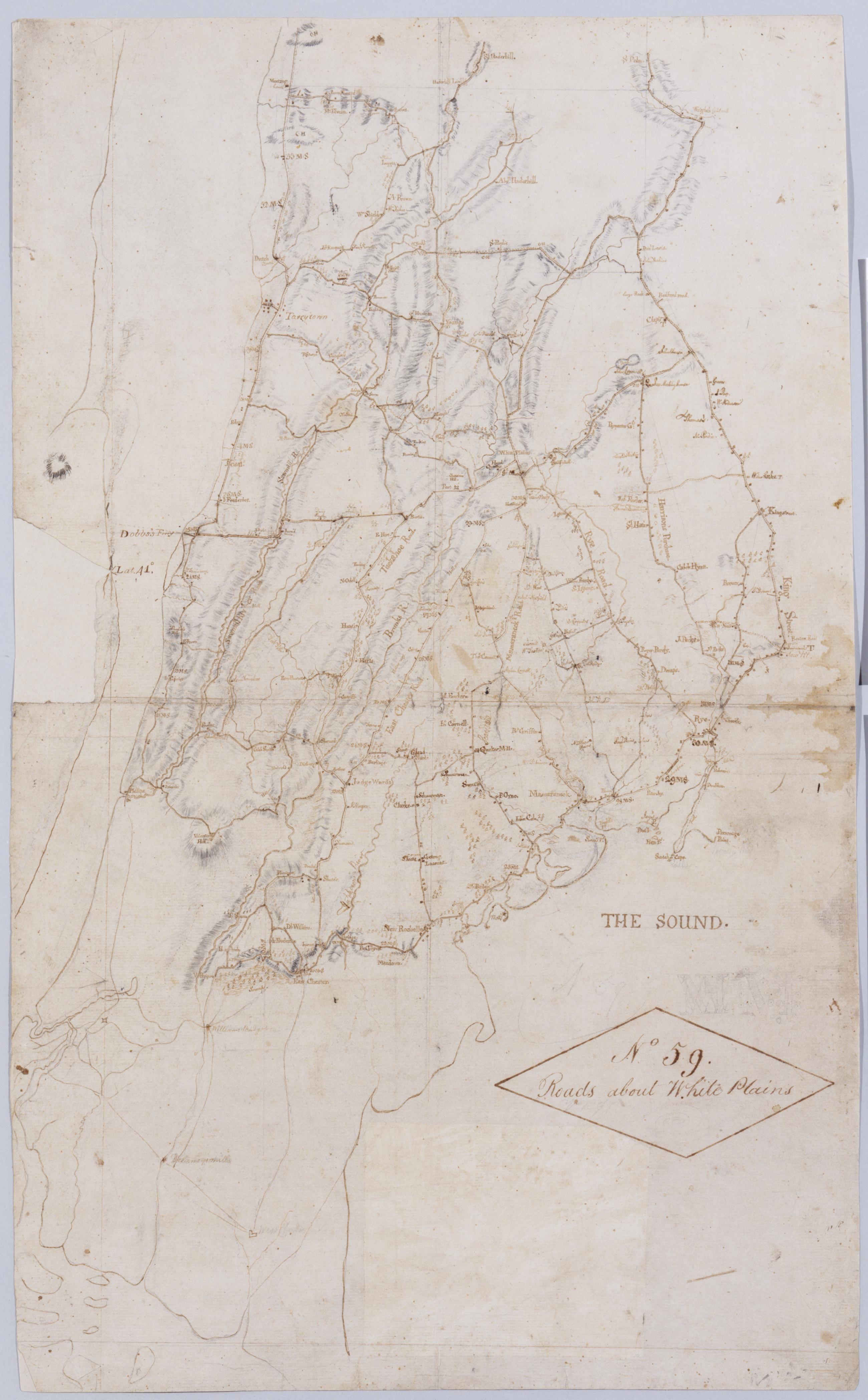
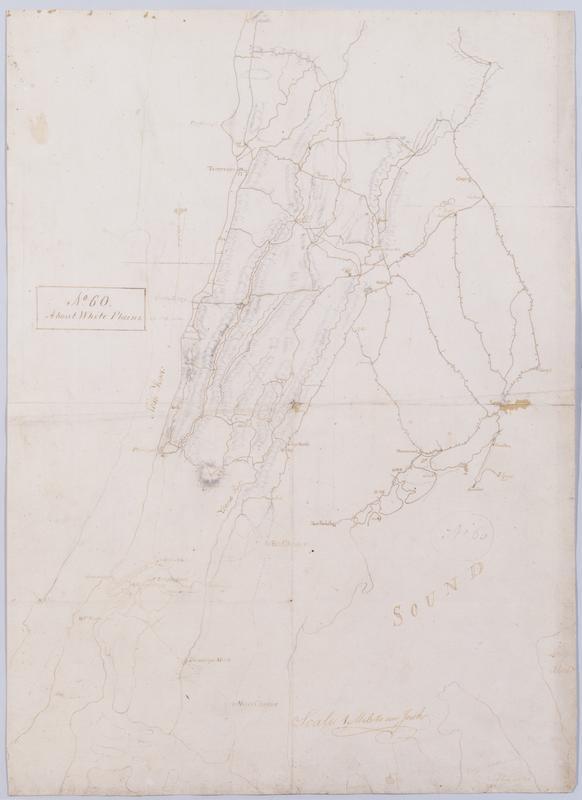
Cartographic Roads about White Plains. No 59 / by Robert Erskine F.R.S. Geogr. A. U.S. and Assistants. A variant of the title given by Guthorn: appears on map No. 120 of the series which, as soiling shows, was once pasted above the lower margin of this map, no. 59. In ink on verso: "No. 59 Joined to No. 25. 32 & 60." There is no evidence that these sheets were ever physically joined, although nos. 25 and 32 do cover adjacent areas. (Map no. 25 is missing.) No. 60 is a copy of this map, no. 59. Military topographic map. Covers most of Westchester County, New York and western Fairfield County, Connecticut; also covers northern New York City. View Item
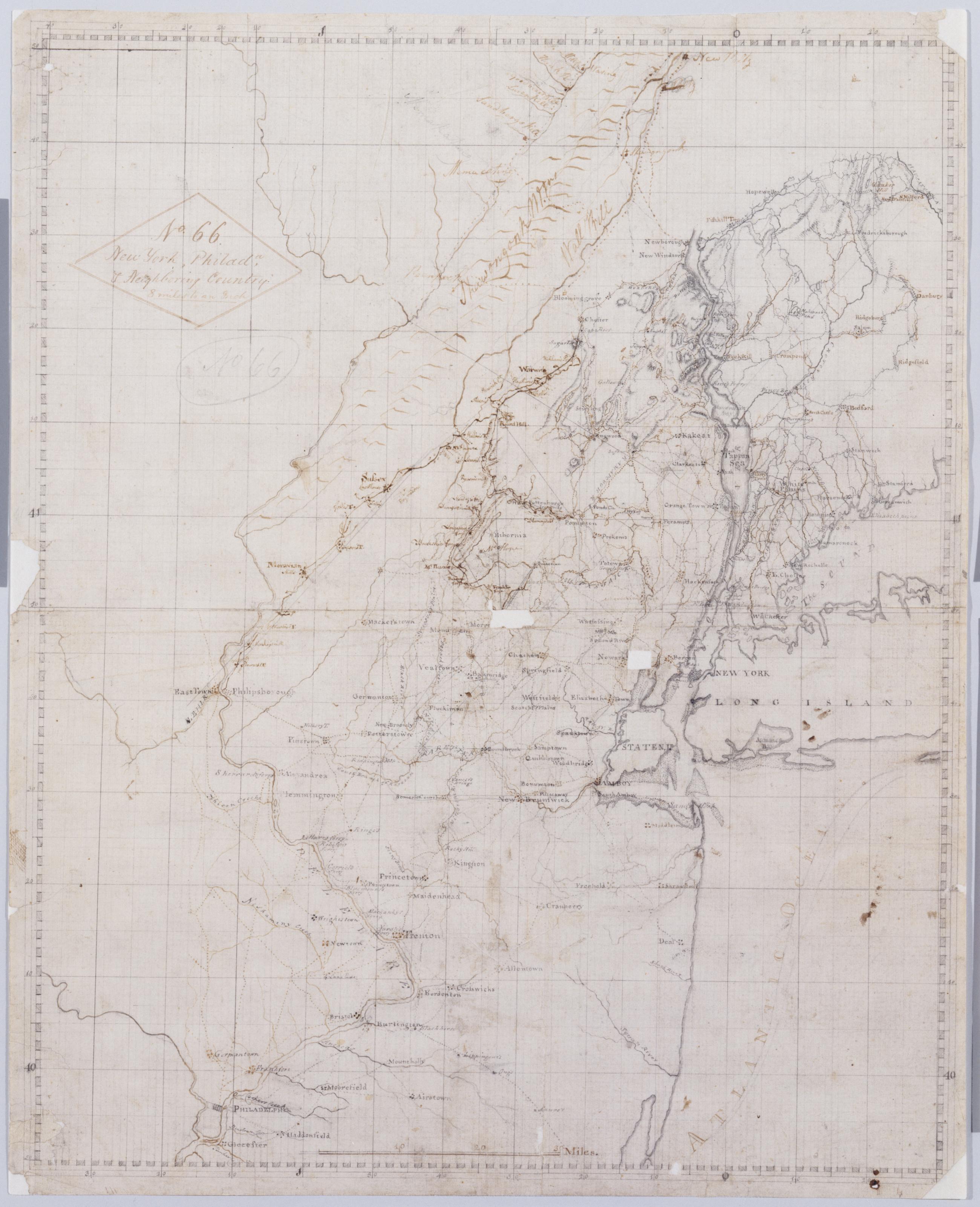
Cartographic New York, Philada, + Neighboring Country : 8 miles to an Inch. No. 66 / [fr.] S. Dewitt ; by Robert Erskine F.R.S. Geogr. A. U.S. and Assistants. Imperfect: lacking two 1 x 1 cm. patches near center of map. In ink on verso: "No. 66-". In pencil on recto: "No 66". Military topographic map. Covers northern New Jersey and adjacent parts of Pennsylvania, New York south of New Paltz, and western Connecticut. Shows roads, towns, streams. Pen-and-ink, grey wash, pencil on laid paper. Prime meridian New York (N.Y.). Shows some relief by hachures. Stained, creased, frayed and abraded. Mounted on cloth, bound and cropped, disbound and silked by subsequent owners. Cleaned after removal of backings 1999; some fill remains. Lined with China paper. View Item
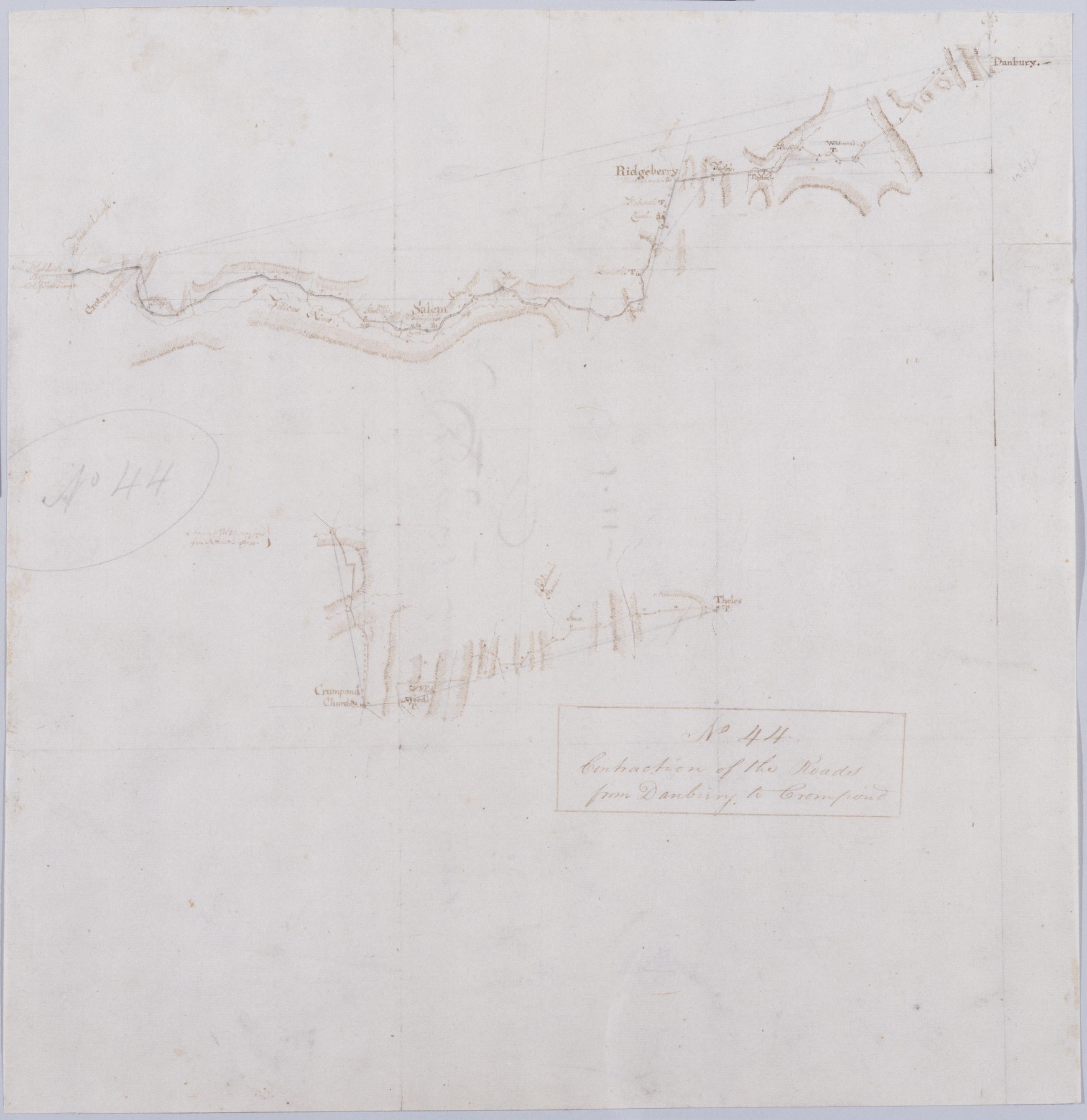
Cartographic Contraction of the Roads from Danbury to Crompond. No 44 / by Robert Erskine F.R.S. Geogr. A. U.S. and Assistants. Foxed, creased, frayed, and abraded. Razorcut along roads for copying. Mounted on cloth, bound and cropped, disbound and silked by subsequent owners. Cleaned after removal of backings 1999; some fill remains. Sheathed in mylar. In pencil on recto: "No 44". Military topographic map; lower segment lies to west of upper segment. Map covers the towns of Ridgefield and Bethel in Fairfield County, Connecticut, and of Yorktown, Somers and North Salem in Westchester County, New York. View Item
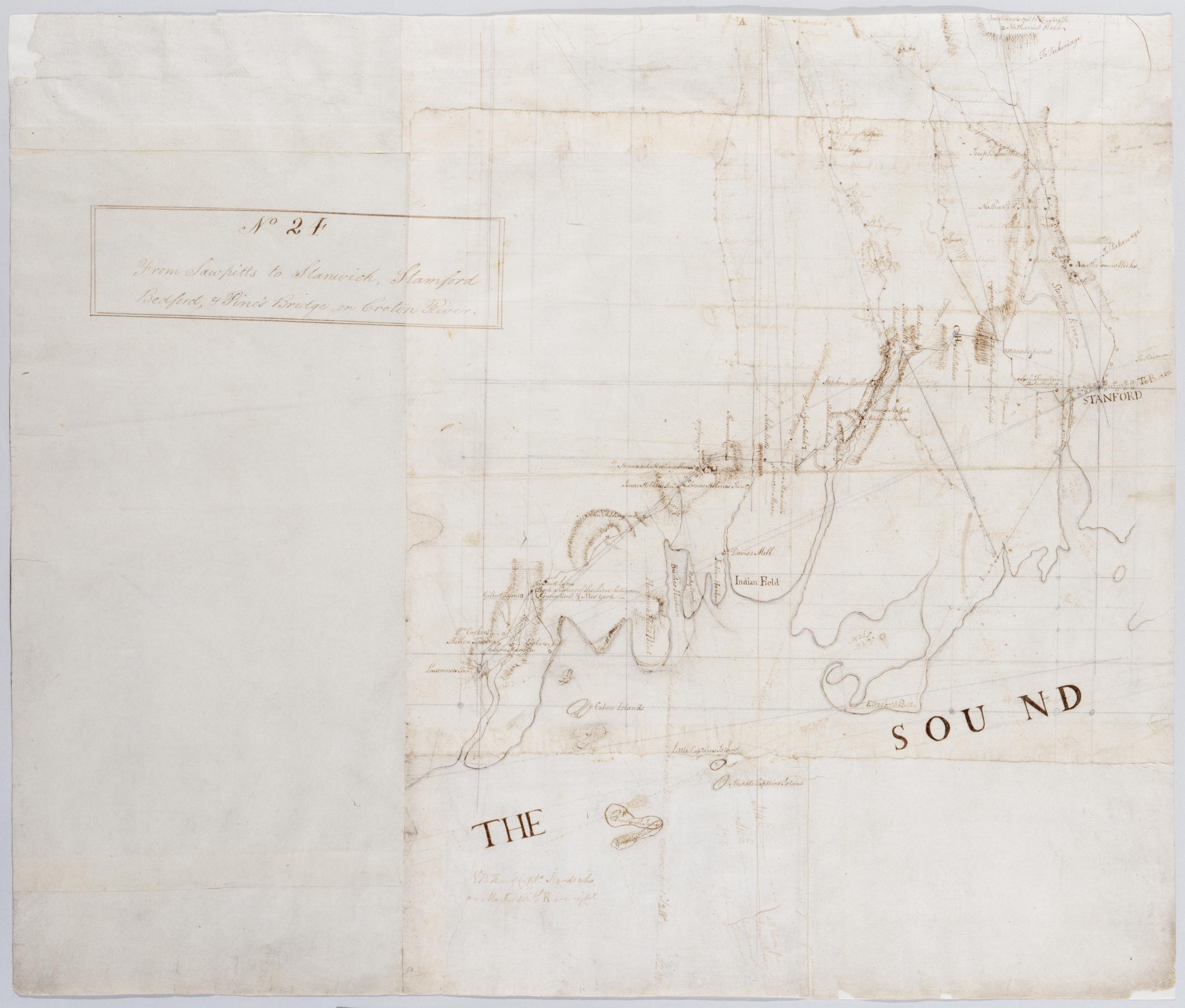
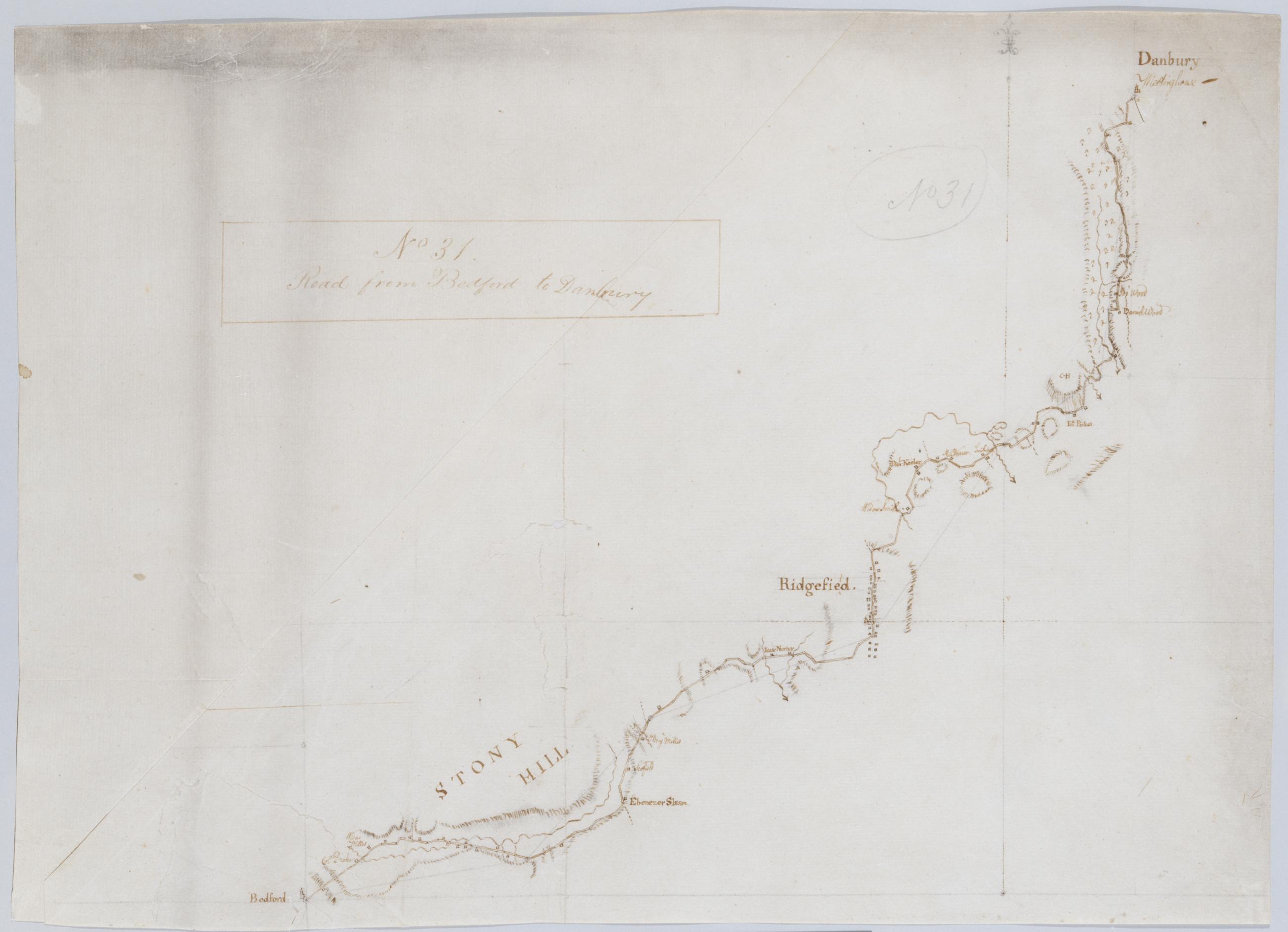
Cartographic Road from Bedford to Danbury. No 31 / by Robert Erskine F.R.S. Geogr. A. U.S. and Assistants. Foxed, creased, frayed, and abraded. Mounted on cloth, bound and cropped, disbound and silked by subsequent owners. Cleaned after removal of backings 1999; some fill remains. Sheathed in mylar. In pencil on recto: "No 31". Military topographic map. Covers the towns of Bedford, Poundridge and Lewisboro in Westchester County, New York and the towns of Bethel and Ridgefield in Fairfield County, Connecticut. Map shows roads running through Danbury, Ridgefield and Bedford. Also shows buildings and owners' names, landforms and streams. Pen-and-ink, pencil on laid paper. View Item
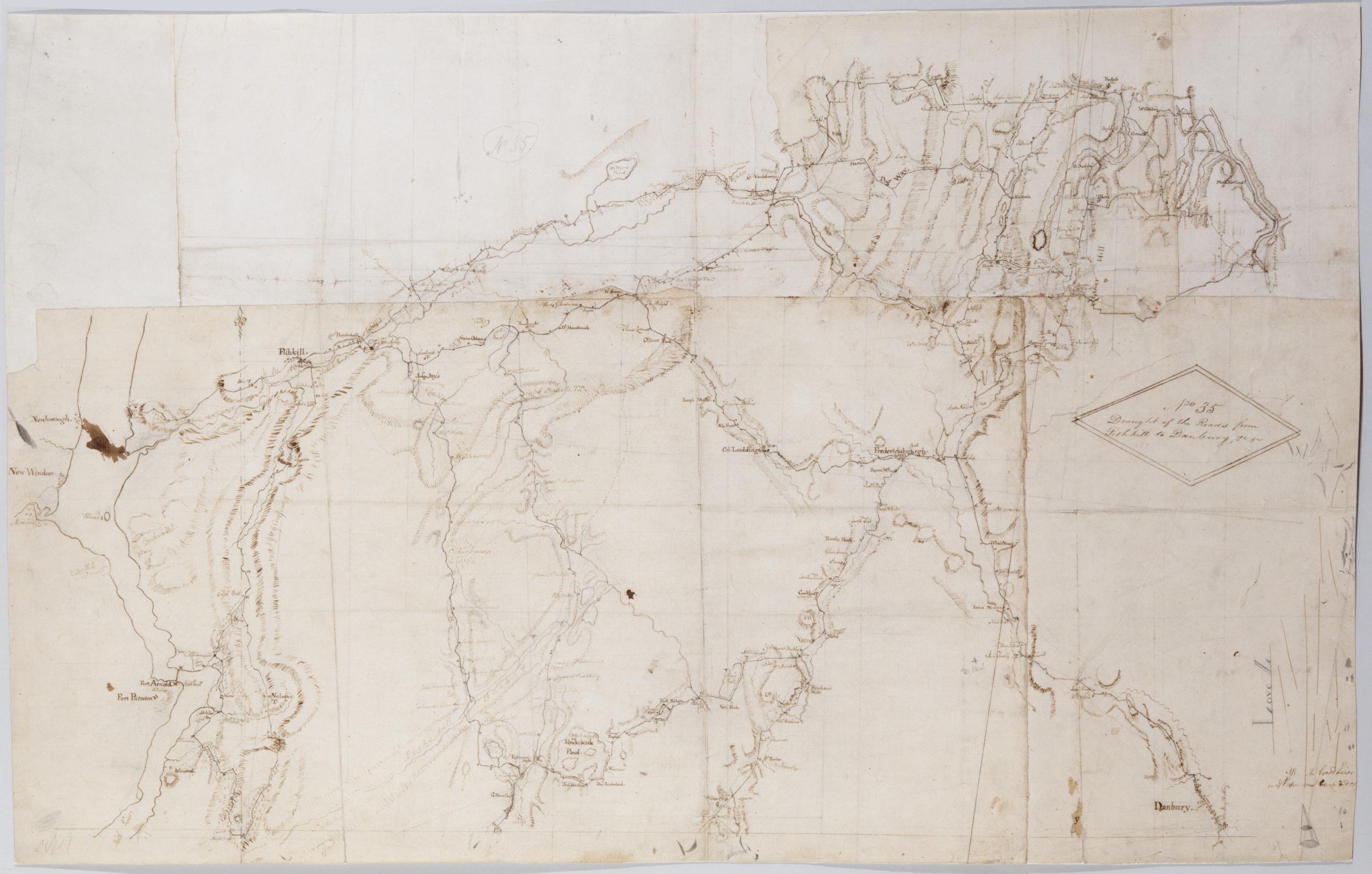
Cartographic Draught of the Roads from Fishkill to Danbury &c. &c. No 35 / by Robert Erskine F.R.S. Geogr. A. U.S. and Assistants. In pencil on recto: "No 35," "Love L". Military topographic map. Covers an area between the Hudson and Houstonic Rivers; i.e., most of Putnam and Dutchess Counties in New York, northern Fairfield County and part of Litchfield County in Connecticut. Shows roads, buildings and owners' names, also landforms and streams. Pen-and-ink, pencil on five pieces laid paper, assembled. Sixth piece at upper left has wove finish. Shows relief by hachures. Title proper from recto is the work of a later editor--Simeon DeWitt or his assign--subsequent to 1820. View Item
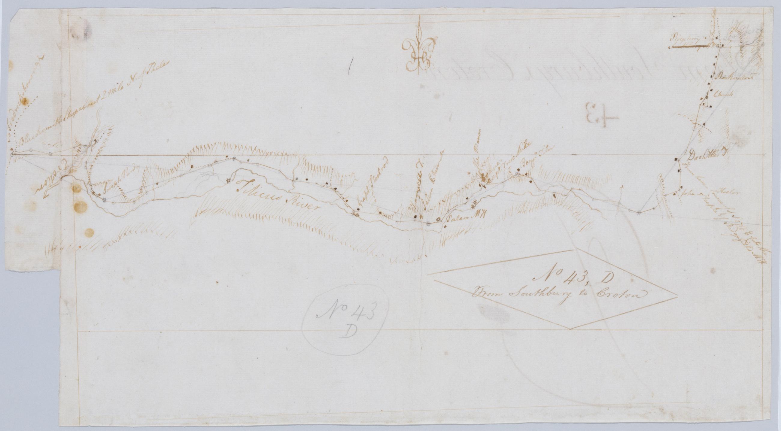
Cartographic From Southbury to Croton. No 43, D / by Robert Erskine F.R.S. Geogr. A. U.S. and Assistants. Foxed, creased, frayed, and abraded. Mounted on cloth, bound and cropped, disbound and silked by subsequent owners. Cleaned after removal of backings 1999; some fill remains. Sheathed in mylar. In pencil on recto: "No 43 D". Military topographic map. Covers the townships of North Salem and Somers in Westchester County, New York, and of Ridgefield in Fairfield County, Connecticut. Shows roads running through Ridgebury, North Salem, Salem Center, Purdy and Somers. Also shows buildings and owners' names, landforms and streams. Pen-and-ink, pencil on laid paper. Shows relief by hachures. View Item
Cartographic About White Plains. No 60 / by Robert Erskine F.R.S. Geogr. A. U.S. and Assistants. In ink on recto: geometrical sketches, "No. 60". In pencil on recto: "No 60". Military topographic map. Covers most of Westchester County, New York and western Fairfield County, Connecticut; also covers northern New York City. Shows roads, buildings and owners' names, also landforms and streams. Pen-and-ink, pencil on laid paper. Shows relief by hachures. Stained, soiled, foxed, creased, frayed and abraded. Mounted on cloth, bound and cropped, disbound and silked by subsequent owners. Cleaned after removal of backings 1999; some fill remains. Sheathed in mylar. View Item
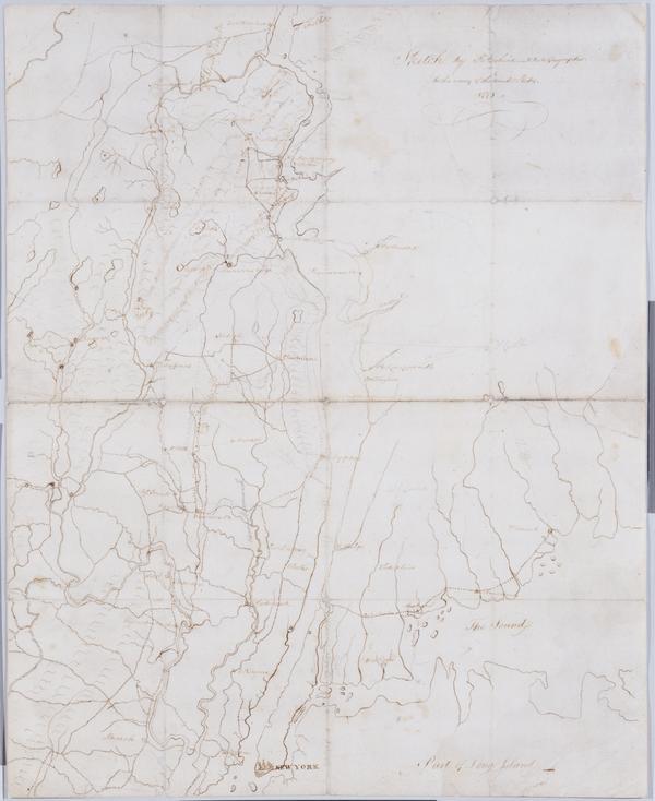
Cartographic Sketch : 1778 / by R Erskine F.R.S., Geographer to the army of the United States. Military topographic map. Covers western Connecticut, the southernmost tip of New York and northwestern New Jersey. Pen-and-ink, pencil on laid paper. Shows relief by hachures and pictorially. Stained, soiled, foxed, creased, frayed and abraded. Mounted on cloth, bound and cropped, disbound and silked by subsequent owners. Cleaned after removal of backings 1999; some fill remains. Newly backed with China paper. Sheathed in mylar. Title proper and statement of responsibility from recto is original. Watermark: "L V GERREVINK" beneath crest, similar to Gravell and Miller foreign watermark no. View Item
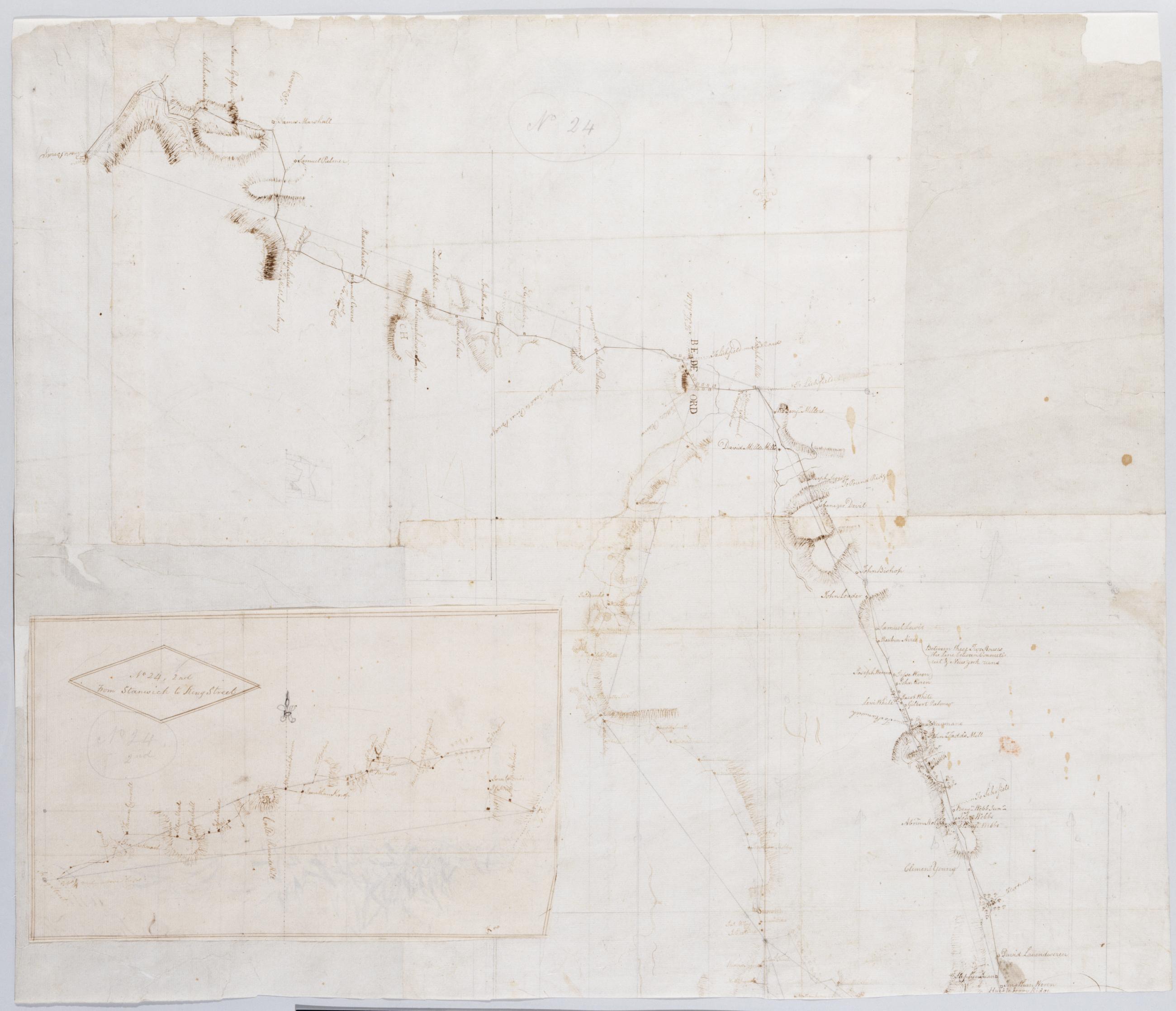
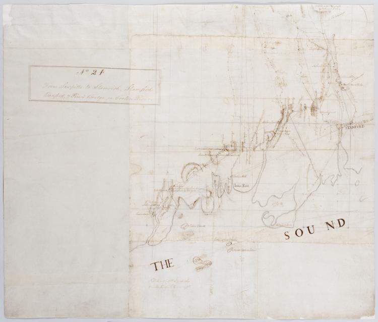
Cartographic From Sawpitts to Stanwich, Stamford Bedford, & Pine's Bridge on Croton River. No. 24 / by Robert Erskine F.R.S. Geogr. A. U.S. and Assistants, inset. Military topographic map. Covers the towns of Yorktown, Newcastle, Bedford, North Castle and Pound Ridge in eastern Westchester County, New York, and the towns of Stamford and Greenwich in Fairfield County, Connecticut. The map itself gives Stamford as "Stanford" and the Mill or Rippowam River as the "Stanford River." It shows roads, buildings and owners' names, also landforms and streams. Maps shows relief by hachures. Titles proper from recto and recto of inset are the work of a later editor--Simeon DeWitt or his assign--subsequent to 1820. View Item
Cartographic From Sawpitts to Stanwich, Stamford Bedford, & Pine's Bridge on Croton River. No. 24 / by Robert Erskine F.R.S. Geogr. A. U.S. and Assistants. Military topographic map. Covers the towns of Yorktown, Newcastle, Bedford, North Castle and Pound Ridge in eastern Westchester County, New York, and the towns of Stamford and Greenwich in Fairfield County, Connecticut. The map itself gives Stamford as "Stanford" and the Mill or Rippowam River as the "Stanford River." It shows roads, buildings and owners' names, also landforms and streams. Maps shows relief by hachures. Titles proper from recto and recto of inset are the work of a later editor--Simeon DeWitt or his assign--subsequent to 1820. View Item
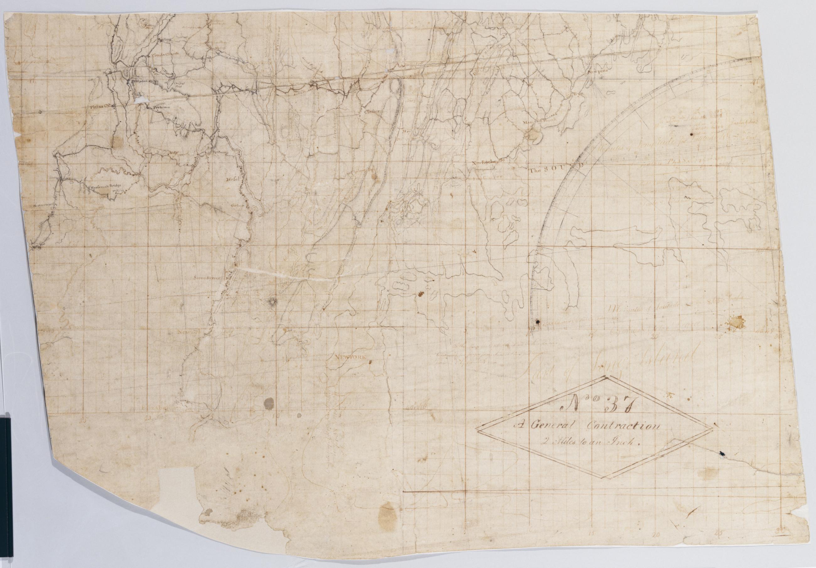
Cartographic A General Contraction 2 Miles to an Inch. No 37 / by R.E. ; by Robert Erskine F.R.S. Geogr. A. U.S. and Assistants, bottom Military topographic map. Covers the lower Hudson River Valley in New York, New Jersey and Connecticut, from Warwick (N.Y.) and Pompton Plains (N.J.) to New Milford and Danbury (Conn.), and from Newburgh (N.Y.) to Staten Island (N.Y.). Shows roads, buildings and owners' names, also landforms and streams. Shows relief by hachures. Title proper from recto is the work of a later editor--Simeon DeWitt or his assign--subsequent to 1820. Index title, both statements of responsibility, date, series title and series numbering by Erskine, but on separate index sheet filed at head of series. View Item
Cartographic A General Contraction 2 Miles to an Inch. No 37 / by R.E. ; by Robert Erskine F.R.S. Geogr. A. U.S. and Assistants, top Military topographic map. Covers the lower Hudson River Valley in New York, New Jersey and Connecticut, from Warwick (N.Y.) and Pompton Plains (N.J.) to New Milford and Danbury (Conn.), and from Newburgh (N.Y.) to Staten Island (N.Y.). Shows roads, buildings and owners' names, also landforms and streams. Shows relief by hachures. Title proper from recto is the work of a later editor--Simeon DeWitt or his assign--subsequent to 1820. Index title, both statements of responsibility, date, series title and series numbering by Erskine, but on separate index sheet filed at head of series. View Item
Image Cartographic 2 Items From Sawpitts to Stanwich, Stamford Bedford, & Pine's Bridge on Croton River. No. 24 / by Robert Erskine F.R.S. Geogr. A. U.S. and Assistants. Military topographic map. Covers the towns of Yorktown, Newcastle, Bedford, North Castle and Pound Ridge in eastern Westchester County, New York, and the towns of Stamford and Greenwich in Fairfield County, Connecticut. The map itself gives Stamford as "Stanford" and the Mill or Rippowam River as the "Stanford River." It shows roads, buildings and owners' names, also landforms and streams. Maps shows relief by hachures. Titles proper from recto and recto of inset are the work of a later editor--Simeon DeWitt or his assign--subsequent to 1820. View Item
Image Cartographic 2 Items A General Contraction 2 Miles to an Inch. No 37 / by R.E. ; by Robert Erskine F.R.S. Geogr. A. U.S. and Assistants. Military topographic map. Covers the lower Hudson River Valley in New York, New Jersey and Connecticut, from Warwick (N.Y.) and Pompton Plains (N.J.) to New Milford and Danbury (Conn.), and from Newburgh (N.Y.) to Staten Island (N.Y.). Shows roads, buildings and owners' names, also landforms and streams. Shows relief by hachures. Title proper from recto is the work of a later editor--Simeon DeWitt or his assign--subsequent to 1820. Index title, both statements of responsibility, date, series title and series numbering by Erskine, but on separate index sheet filed at head of series. View Item
Cartographic Through Newtown. No 43 B / by Robert Erskine F.R.S. Geogr. A. U.S. and Assistants. Foxed- creased- frayed- and abraded. Mounted on cloth- bound and cropped- disbound and silked by subsequent owners. Cleaned after removal of backings 1999; some fill remains. Sheathed in mylar. In pencil on recto: "No 43 B". Military topographic map. Covers the township of Newtown in Fairfield County- Connecticut. Shows roads running through Sandy Hook and Newtown. Also shows buildings and owners' names- landforms and streams. Pen-and-ink- pencil on laid paper. Shows relief by hachures. Title proper from recto is the work of a later editor--Simeon DeWitt or his assign--subsequent to 1820. View Item
Cartographic From Woodbury to the Continental Bridge near Newtown. No 43 A / by Robert Erskine F.R.S. Geogr. A. U.S. and Assistants. In pencil on recto: "No 43 A". Military topographic map. Covers the townships of Southbury- Woodbury and Middlebury in New Haven County and of Newtown in Fairfield County- Connecticut. Shows roads running through Woodbury- White Oaks- Southbury- Pomperaug Valley and Bennetts Bridge. Also shows buildings and owners' names- landforms and streams. Pen-and-ink- pencil on laid paper. Shows relief by hachures. Soiled- foxed- creased- frayed- and abraded. Mounted on cloth- bound and cropped- disbound and silked by subsequent owners. Cleaned after removal of backings 1999; some fill remains. View Item
Cartographic Through Danbury to Southbury. No 43 C / by Robert Erskine F.R.S. Geogr. A. U.S. and Assistants. Foxed- creased- frayed- and abraded. Mounted on cloth- bound and cropped- disbound and silked by subsequent owners. Cleaned after removal of backings 1999; some fill remains. Sheathed in mylar. Military topographic map. Covers the townships of Bethel- Danbury and Ridgefield in Fairfield County- Connecticut. Shows roads running through East Danbury and Danbury. Also shows buildings and owners' names- landforms and streams. Pen-and-ink- pencil on laid paper. Shows relief by hachures. Title proper from recto is the work of a later editor--Simeon DeWitt or his assign--subsequent to 1820. View Item
Cartographic Roads about White Plains. No 59 / by Robert Erskine F.R.S. Geogr. A. U.S. and Assistants. A variant of the title given by Guthorn: appears on map No. 120 of the series which- as soiling shows- was once pasted above the lower margin of this map- no. 59. In ink on verso: "No. 59 Joined to No. 25. 32 & 60." There is no evidence that these sheets were ever physically joined- although nos. 25 and 32 do cover adjacent areas. (Map no. 25 is missing.) No. 60 is a copy of this map- no. 59. Military topographic map. Covers most of Westchester County- New York and western Fairfield County- Connecticut; also covers northern New York City. View Item
Cartographic New York Philada + Neighboring Country : 8 miles to an Inch. No. 66 / [fr.] S. Dewitt ; by Robert Erskine F.R.S. Geogr. A. U.S. and Assistants. Imperfect: lacking two 1 x 1 cm. patches near center of map. In ink on verso: "No. 66-". In pencil on recto: "No 66". Military topographic map. Covers northern New Jersey and adjacent parts of Pennsylvania- New York south of New Paltz- and western Connecticut. Shows roads- towns- streams. Pen-and-ink- grey wash- pencil on laid paper. Prime meridian New York (N.Y.). Shows some relief by hachures. Stained- creased- frayed and abraded. Mounted on cloth- bound and cropped- disbound and silked by subsequent owners. Cleaned after removal of backings 1999; some fill remains. Lined with China paper. View Item
Cartographic Contraction of the Roads from Danbury to Crompond. No 44 / by Robert Erskine F.R.S. Geogr. A. U.S. and Assistants. Foxed- creased- frayed- and abraded. Razorcut along roads for copying. Mounted on cloth- bound and cropped- disbound and silked by subsequent owners. Cleaned after removal of backings 1999; some fill remains. Sheathed in mylar. In pencil on recto: "No 44". Military topographic map; lower segment lies to west of upper segment. Map covers the towns of Ridgefield and Bethel in Fairfield County- Connecticut- and of Yorktown- Somers and North Salem in Westchester County- New York. View Item
Cartographic Road from Bedford to Danbury. No 31 / by Robert Erskine F.R.S. Geogr. A. U.S. and Assistants. Foxed- creased- frayed- and abraded. Mounted on cloth- bound and cropped- disbound and silked by subsequent owners. Cleaned after removal of backings 1999; some fill remains. Sheathed in mylar. In pencil on recto: "No 31". Military topographic map. Covers the towns of Bedford- Poundridge and Lewisboro in Westchester County- New York and the towns of Bethel and Ridgefield in Fairfield County- Connecticut. Map shows roads running through Danbury- Ridgefield and Bedford. Also shows buildings and owners' names- landforms and streams. Pen-and-ink- pencil on laid paper. View Item
Cartographic Draught of the Roads from Fishkill to Danbury &c. &c. No 35 / by Robert Erskine F.R.S. Geogr. A. U.S. and Assistants. In pencil on recto: "No 35-" "Love L". Military topographic map. Covers an area between the Hudson and Houstonic Rivers; i.e.- most of Putnam and Dutchess Counties in New York- northern Fairfield County and part of Litchfield County in Connecticut. Shows roads- buildings and owners' names- also landforms and streams. Pen-and-ink- pencil on five pieces laid paper- assembled. Sixth piece at upper left has wove finish. Shows relief by hachures. Title proper from recto is the work of a later editor--Simeon DeWitt or his assign--subsequent to 1820. View Item
Cartographic From Southbury to Croton. No 43 D / by Robert Erskine F.R.S. Geogr. A. U.S. and Assistants. Foxed- creased- frayed- and abraded. Mounted on cloth- bound and cropped- disbound and silked by subsequent owners. Cleaned after removal of backings 1999; some fill remains. Sheathed in mylar. In pencil on recto: "No 43 D". Military topographic map. Covers the townships of North Salem and Somers in Westchester County- New York- and of Ridgefield in Fairfield County- Connecticut. Shows roads running through Ridgebury- North Salem- Salem Center- Purdy and Somers. Also shows buildings and owners' names- landforms and streams. Pen-and-ink- pencil on laid paper. Shows relief by hachures. View Item
Cartographic About White Plains. No 60 / by Robert Erskine F.R.S. Geogr. A. U.S. and Assistants. In ink on recto: geometrical sketches- "No. 60". In pencil on recto: "No 60". Military topographic map. Covers most of Westchester County- New York and western Fairfield County- Connecticut; also covers northern New York City. Shows roads- buildings and owners' names- also landforms and streams. Pen-and-ink- pencil on laid paper. Shows relief by hachures. Stained- soiled- foxed- creased- frayed and abraded. Mounted on cloth- bound and cropped- disbound and silked by subsequent owners. Cleaned after removal of backings 1999; some fill remains. Sheathed in mylar. View Item
Cartographic Sketch : 1778 / by R Erskine F.R.S. Geographer to the army of the United States. Military topographic map. Covers western Connecticut- the southernmost tip of New York and northwestern New Jersey. Pen-and-ink- pencil on laid paper. Shows relief by hachures and pictorially. Stained- soiled- foxed- creased- frayed and abraded. Mounted on cloth- bound and cropped- disbound and silked by subsequent owners. Cleaned after removal of backings 1999; some fill remains. Newly backed with China paper. Sheathed in mylar. Title proper and statement of responsibility from recto is original. Watermark: "L V GERREVINK" beneath crest- similar to Gravell and Miller foreign watermark no. View Item
Cartographic From Sawpitts to Stanwich Stamford Bedford & Pine's Bridge on Croton River. No. 24 / by Robert Erskine F.R.S. Geogr. A. U.S. and Assistants. Military topographic map. Covers the towns of Yorktown- Newcastle- Bedford- North Castle and Pound Ridge in eastern Westchester County- New York- and the towns of Stamford and Greenwich in Fairfield County- Connecticut. The map itself gives Stamford as "Stanford" and the Mill or Rippowam River as the "Stanford River." It shows roads- buildings and owners' names- also landforms and streams. Maps shows relief by hachures. Titles proper from recto and recto of inset are the work of a later editor--Simeon DeWitt or his assign--subsequent to 1820. View Item
Cartographic A General Contraction 2 Miles to an Inch. No 37 / by R.E. ; by Robert Erskine F.R.S. Geogr. A. U.S. and Assistants. Military topographic map. Covers the lower Hudson River Valley in New York- New Jersey and Connecticut- from Warwick (N.Y.) and Pompton Plains (N.J.) to New Milford and Danbury (Conn.)- and from Newburgh (N.Y.) to Staten Island (N.Y.). Shows roads- buildings and owners' names- also landforms and streams. Shows relief by hachures. Title proper from recto is the work of a later editor--Simeon DeWitt or his assign--subsequent to 1820. Index title- both statements of responsibility- date- series title and series numbering by Erskine- but on separate index sheet filed at head of series. View Item