Cartographic Projections +c for closing and trying the meeting of Surveys. No. 99, C / Large paper by Capt. Scull ; by Robert Erskine F.R.S. Geogr. A. U.S. and Assistants. In ink on verso: "No. 99 C". In pencil on recto: "No 99 C". Military topographic map; an early draft. Covers Mercer, Burlington and Camden counties in New Jersey, Montgomery County and Philadelphia in Pennsylvania. Pen-and-ink, pencil on laid paper. Soiled, stained, creased and abraded. Mounted on cloth, bound and cropped, disbound and silked by subsequent owners. Cleaned after removal of backings 1999; some fill remains. Sheathed in mylar. Title proper from recto is the work of a later editor--Simeon DeWitt or his assign--subsequent to 1820. View Item
Cartographic From Bethlehem to Broad Axe. No 58 / by Robert Erskine F.R.S. Geogr. A. U.S. and Assistants. In ink on verso: "No 58" (partly damaged by cropping). In pencil on recto: "58". Military topographic map. Covers Northhampton, Bucks and Montgomery counties, Pennsylvania. Shows roads running through Bethlehem, Hellertown, Pleasant Valley, Strawntown, Keelersville, Hagersville, Doyles Corner, Trewigtown, Montgomeryville, Spring House, Ambler and Fort Washington. Also shows buildings and owners' names, landforms and streams. Pen-and-ink, pencil on laid paper. Shows relief by hachures. Stained, foxed and abraded. Mounted on cloth, bound and cropped, disbound and silked by subsequent owners. View Item
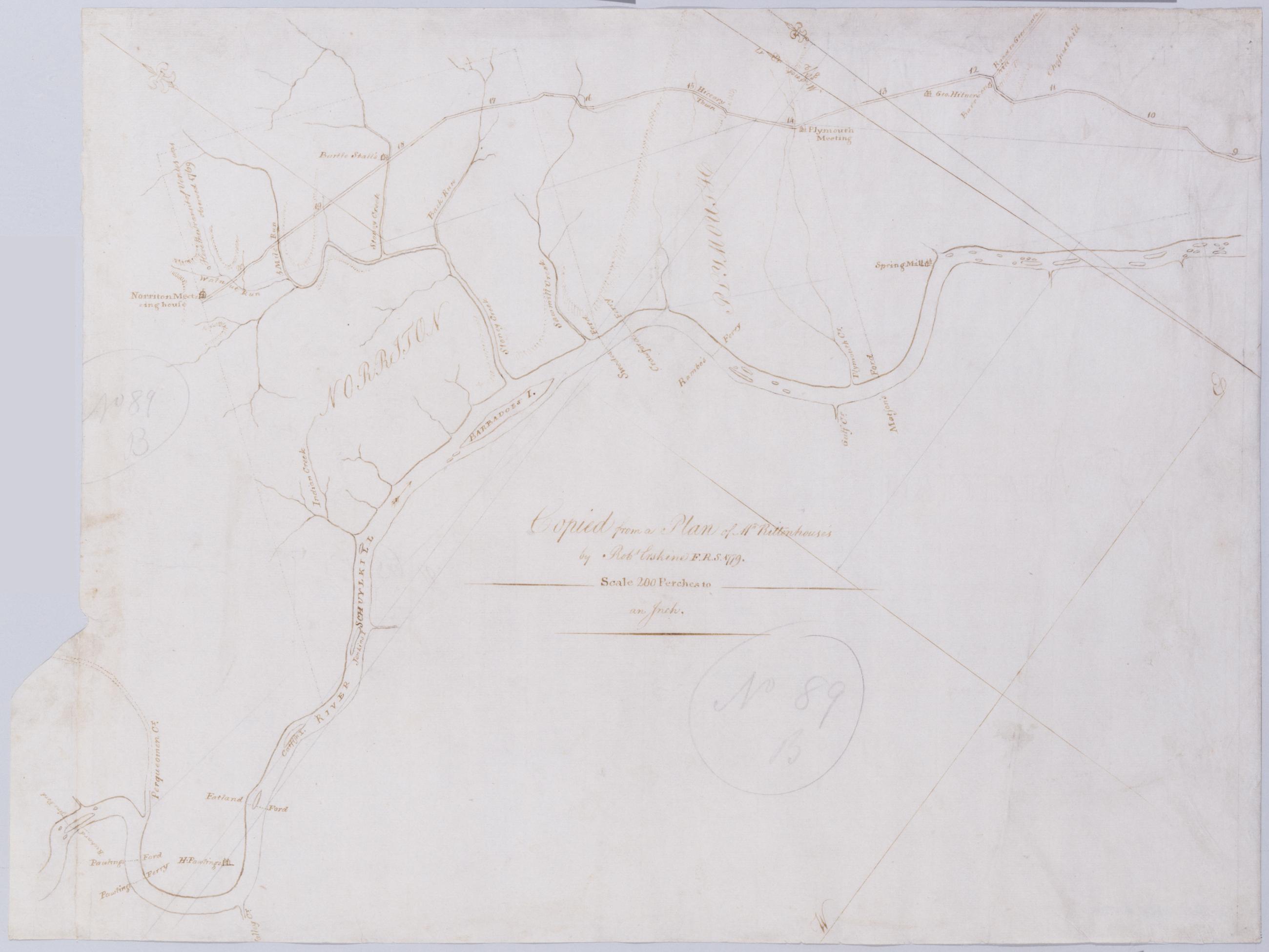
Cartographic [A Contraction of Do.] No. 89 B. / Copied from a Plan of Mr Rittenhouse's by Robt Erskine F.R.S. 1779 ; by Robert Erskine F.R.S. Geogr. A. U.S. and Assistants. Foxed, soiled, frayed. Sheathed in mylar. In ink on verso: "No. 89 B." In pencil on recto: "No 89 B". Military topographic map. Covers the counties of Chester, Montgomery and Delaware, Pennsylvania. Shows roads running through Norristown and Philadelphia. Also shows buildings and owners' names, landforms and streams. No title on recto or verso; title proper supplied by cataloger. Title number from map verso. First statement of responsibility from map recto. View Item
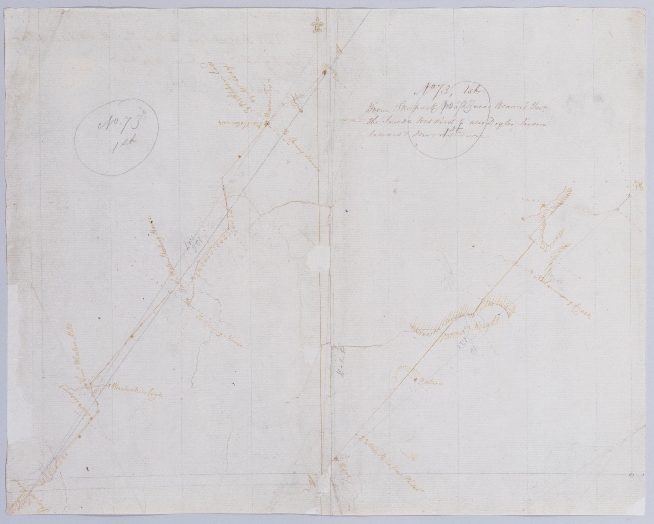
Cartographic From Skeepack Road near Weaver's Tavn. the Swede Ford Road to near Doyles Tavern towards Morristown. No 73, 1st / by Robert Erskine F.R.S. Geogr. A. U.S. and Assistants. Creased, torn, frayed and abraded. Mounted on cloth, bound and cropped, disbound and silked by subsequent owners. Cleaned after removal of backings 1999; some fill remains. Sheathed in mylar. Imperfect: lacking 2 x 2 cm. at center. In pencil on recto: "No 73 1st" (twice). Military topographic map. Covers Bucks and Montgomery counties, Pennsylvania. Shows roads running through Norristown, North Wales, New Britain and Doylestown. Also shows buildings and owners' names, landforms and streams. Pen-and-ink, pencil on laid paper. Shows relief by hachures. View Item
Cartographic From the Green Tree Tavern to the Broad Axe Tavern. No 57, D / by Robert Erskine F.R.S. Geogr. A. U.S. and Assistants. Foxed, creased and abraded. Mounted on cloth, bound and cropped, disbound and silked by subsequent owners. Cleaned after removal of backings 1999; some fill remains. Sheathed in mylar. In pencil on recto: "57 D". Military topographic map. Covers Montgomery County, Pennsylvania. Shows roads running through Trewigtown, Colmar, Montgomeryville, Spring House, Ambler and Fort Washington. Also shows buildings and owners' names, landforms and streams. Pen-and-ink, pencil on laid paper. Second sheet is a mere 5 x 8 cm. tab at lower margin of main sheet. Shows relief by hachures. View Item
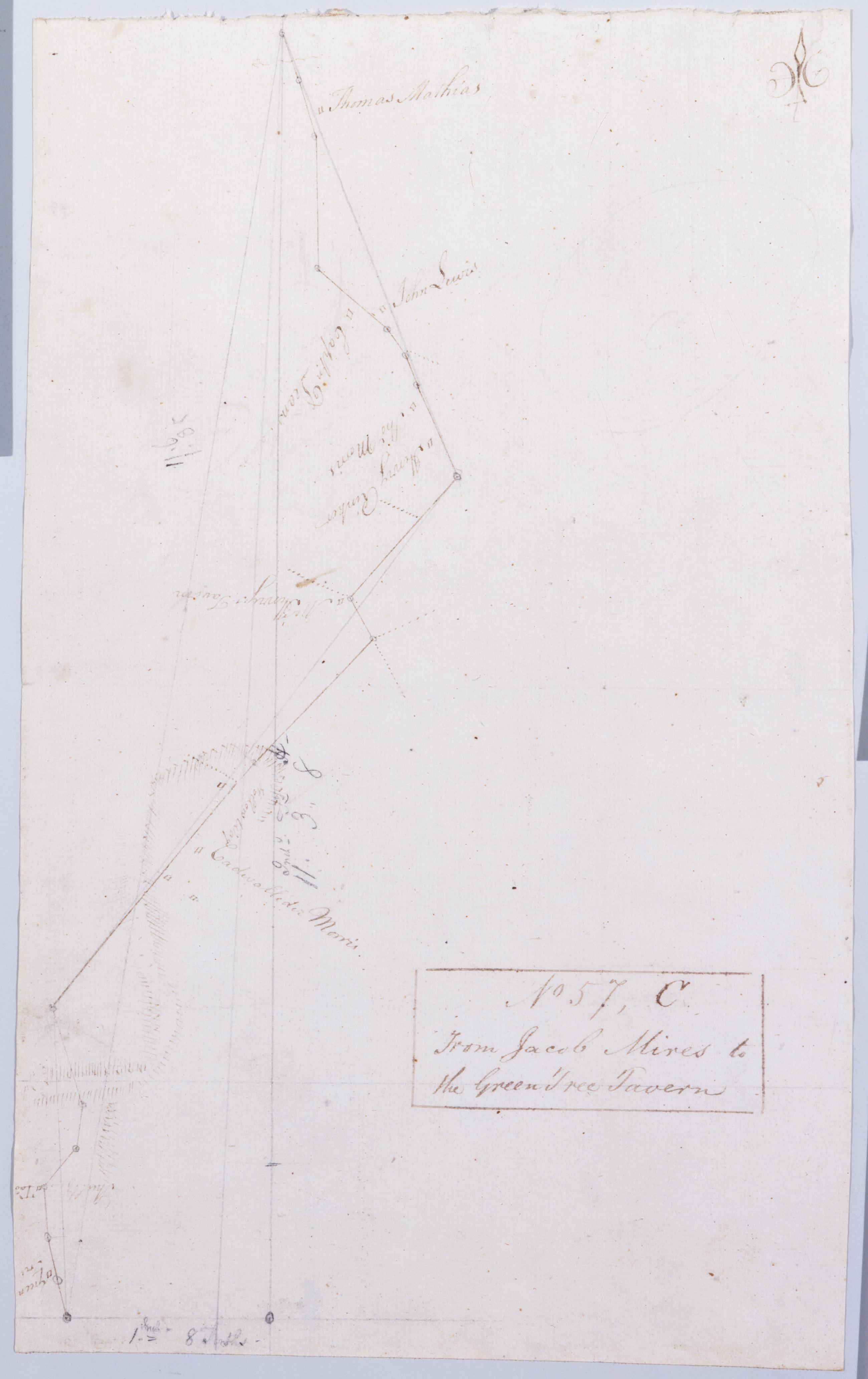
Cartographic From Jacob Mires to the Green Tree Tavern. No 57, C / by Robert Erskine F.R.S. Geogr. A. U.S. and Assistants. Also in ink on verso: "Monmouth Court House". Foxed, creased and abraded. Mounted on cloth, bound and cropped, disbound and silked by subsequent owners. Cleaned after removal of backings 1999; some fill remains. Sheathed in mylar. In pencil on recto: "57 C". Military topographic map. Covers Bucks and Montgomery counties, Pennsylvania. Shows roads running through Doyles Corner. Also shows buildings and owners' names, landforms and streams. Pen-and-ink, pencil on laid paper. Shows relief by hachures. View Item
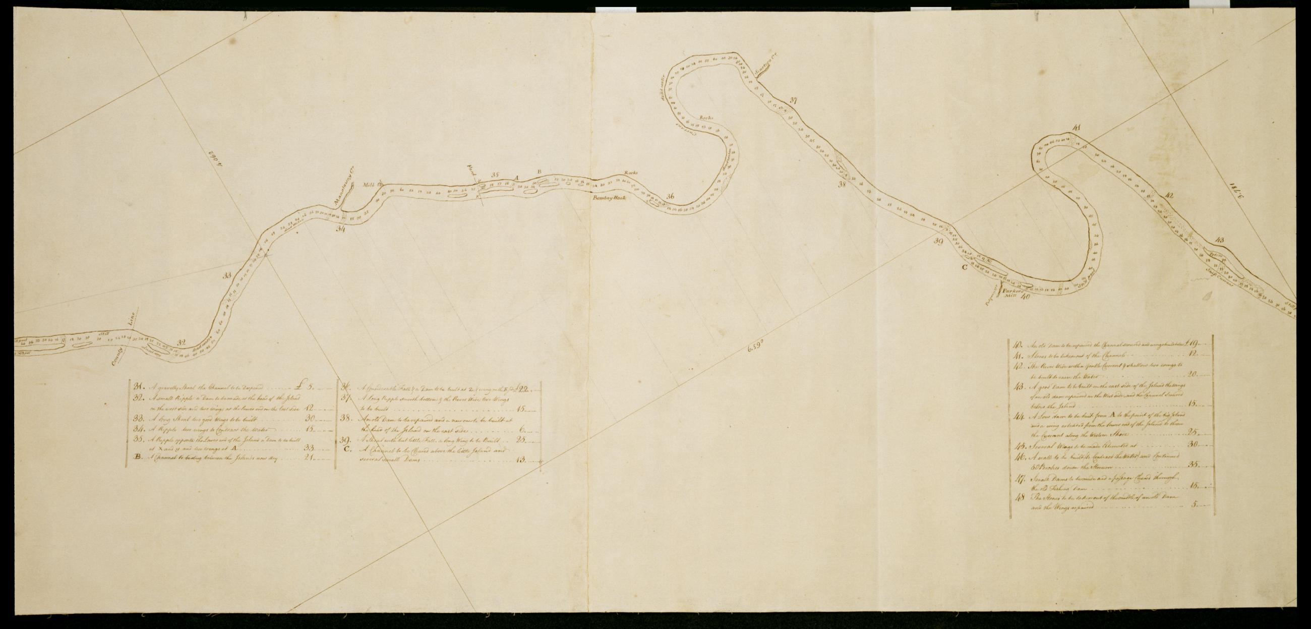
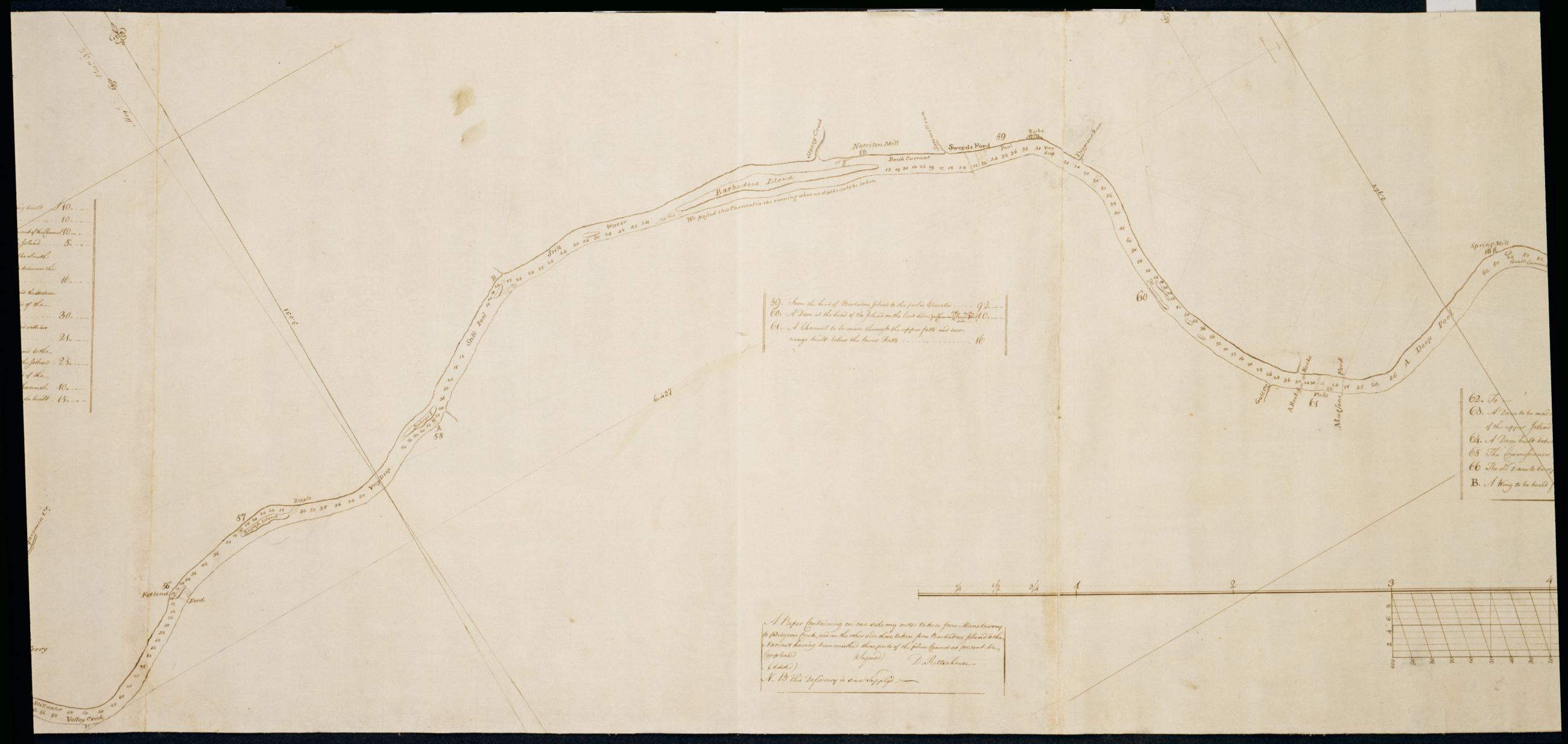
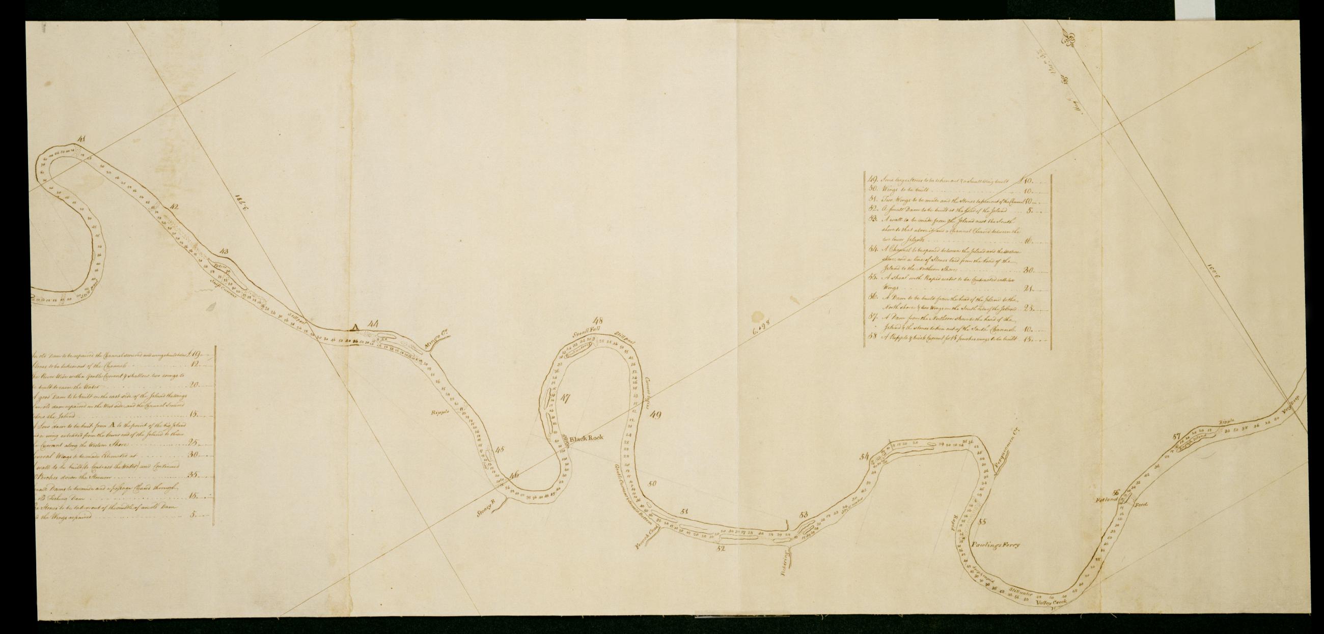
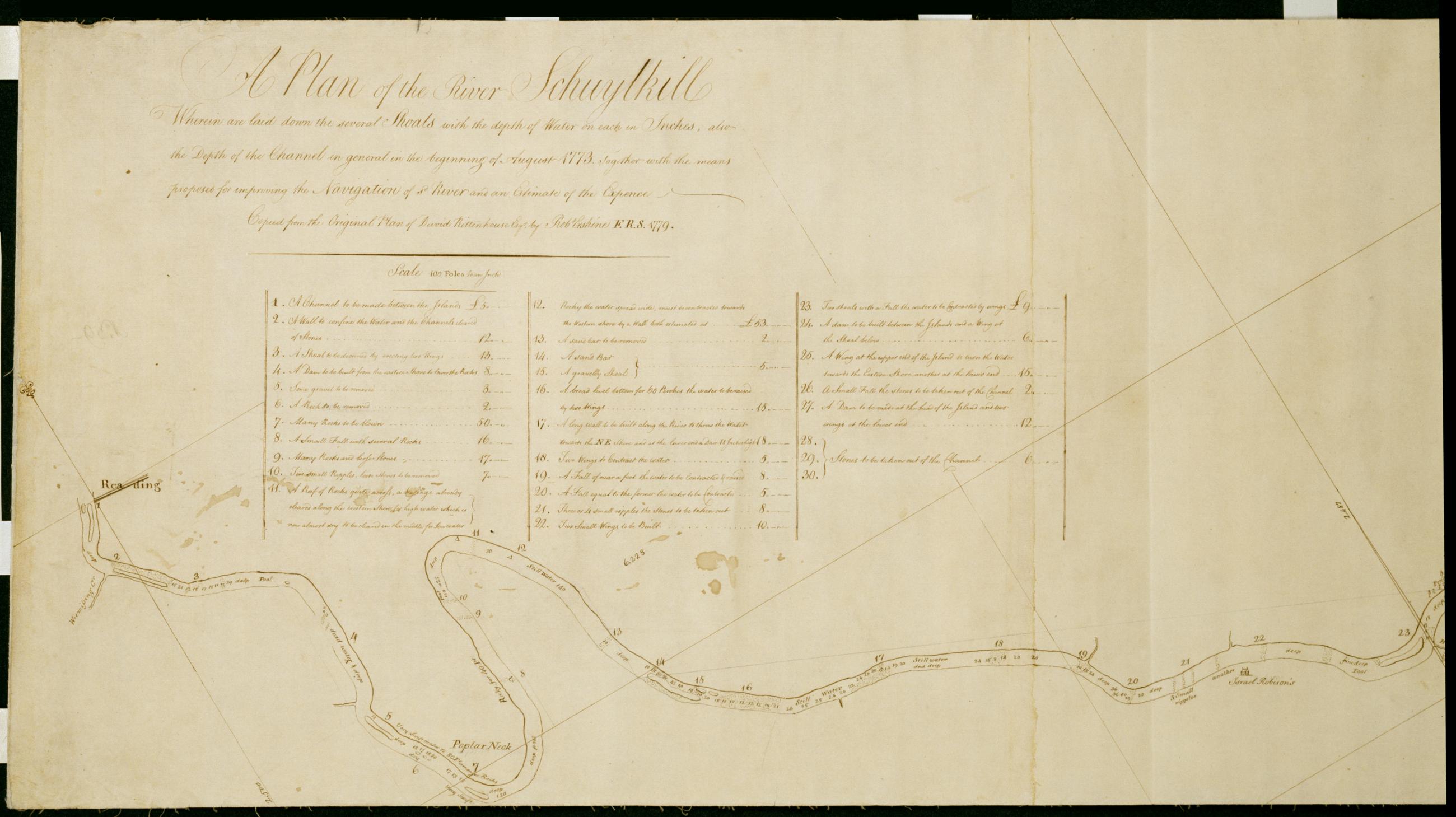
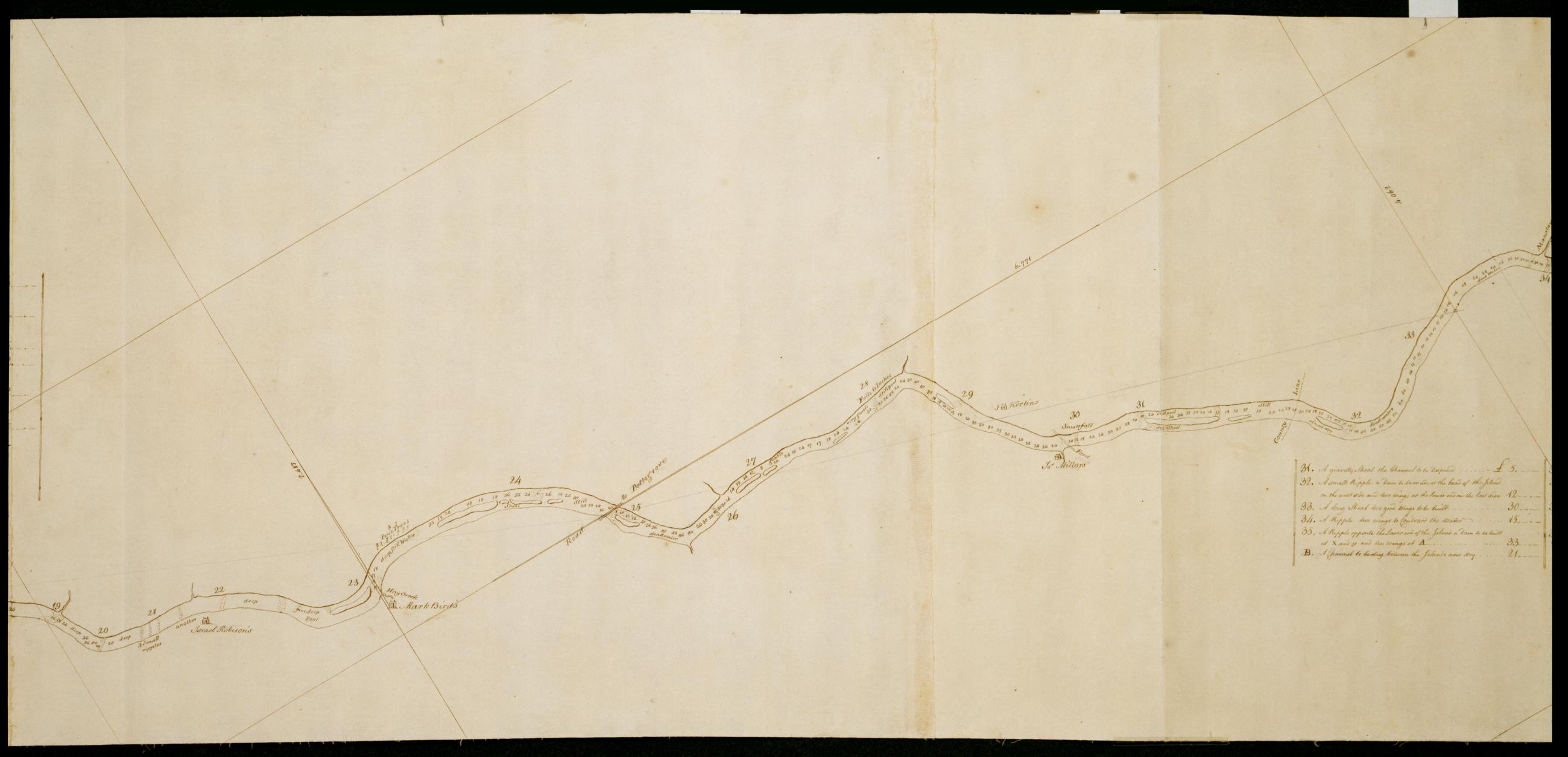
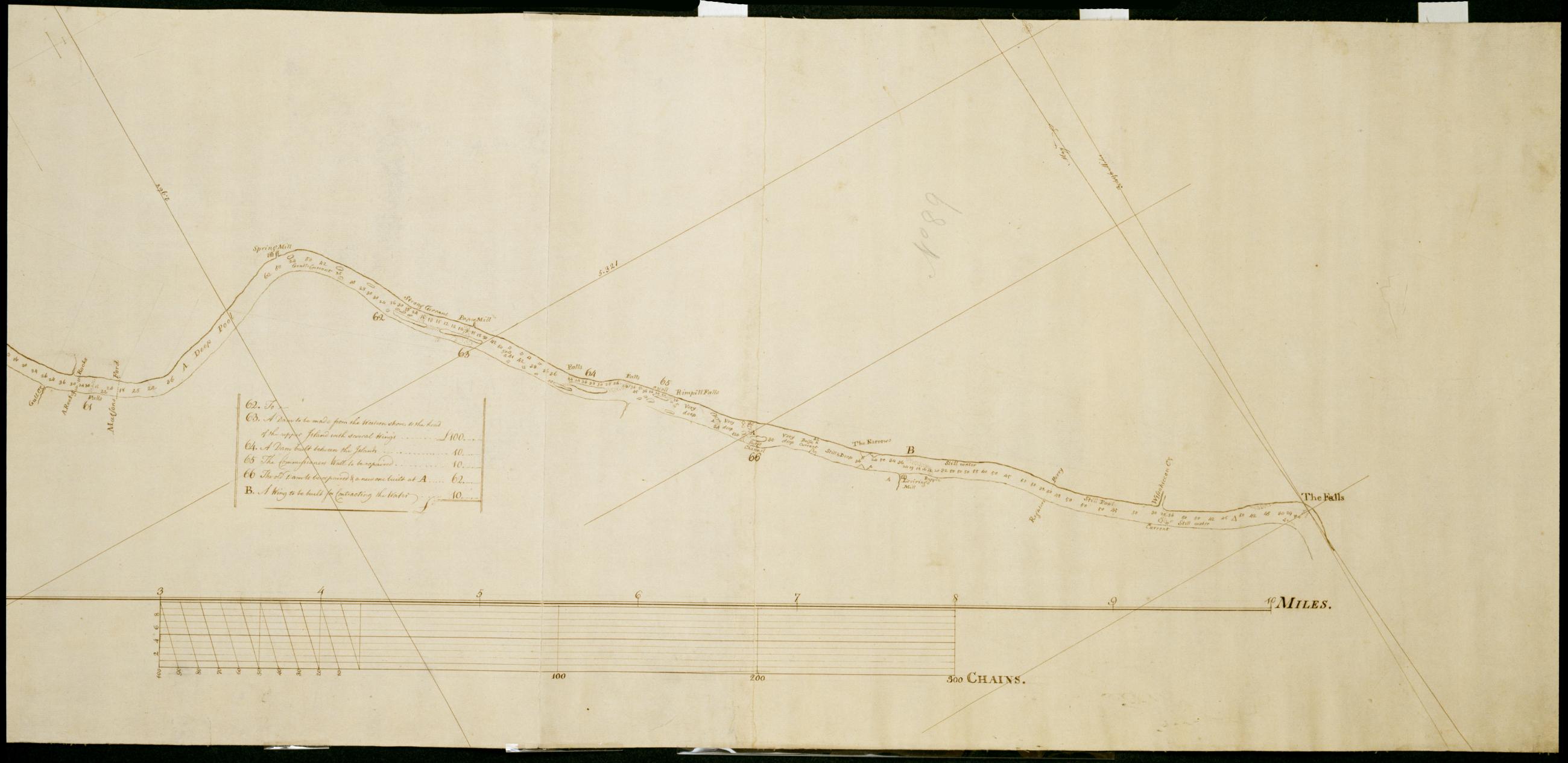
Cartographic A Plan of the River Schuylkill Wherein are laid down the several Shoals with the depth of Water on each in Inches, also the Depth of the Channel in general in the beginning of August 1773, Together with the means proposed for improving the Navigation of s Foxed, soiled, stained and creased. Mounted on cloth and cropped. In pencil on recto: "No 89". Includes index to 66 numbered features. Military topographic map. Covers the counties of Berks, Chester, Montgomery and Philadelphia, Pennsylvania, between Reading and Philadelphia. Shows river features and depths by soundings. Does not show landward features. Pen-and-ink, pencil on laid paper. Title proper and first statement of responsibility from map recto. Title number supplied by cataloger. View Item
Cartographic A Plan of the River Schuylkill Wherein are laid down the several Shoals with the depth of Water on each in Inches, also the Depth of the Channel in general in the beginning of August 1773, Together with the means proposed for improving the Navigation of s Foxed, soiled, stained and creased. Mounted on cloth and cropped. In pencil on recto: "No 89". Includes index to 66 numbered features. Military topographic map. Covers the counties of Berks, Chester, Montgomery and Philadelphia, Pennsylvania, between Reading and Philadelphia. Shows river features and depths by soundings. Does not show landward features. Pen-and-ink, pencil on laid paper. Title proper and first statement of responsibility from map recto. Title number supplied by cataloger. View Item
Cartographic A Plan of the River Schuylkill Wherein are laid down the several Shoals with the depth of Water on each in Inches, also the Depth of the Channel in general in the beginning of August 1773, Together with the means proposed for improving the Navigation of s Foxed, soiled, stained and creased. Mounted on cloth and cropped. In pencil on recto: "No 89". Includes index to 66 numbered features. Military topographic map. Covers the counties of Berks, Chester, Montgomery and Philadelphia, Pennsylvania, between Reading and Philadelphia. Shows river features and depths by soundings. Does not show landward features. Pen-and-ink, pencil on laid paper. Title proper and first statement of responsibility from map recto. Title number supplied by cataloger. View Item
Cartographic A Plan of the River Schuylkill Wherein are laid down the several Shoals with the depth of Water on each in Inches, also the Depth of the Channel in general in the beginning of August 1773, Together with the means proposed for improving the Navigation of s Foxed, soiled, stained and creased. Mounted on cloth and cropped. In pencil on recto: "No 89". Includes index to 66 numbered features. Military topographic map. Covers the counties of Berks, Chester, Montgomery and Philadelphia, Pennsylvania, between Reading and Philadelphia. Shows river features and depths by soundings. Does not show landward features. Pen-and-ink, pencil on laid paper. Title proper and first statement of responsibility from map recto. Title number supplied by cataloger. View Item
Cartographic A Plan of the River Schuylkill Wherein are laid down the several Shoals with the depth of Water on each in Inches, also the Depth of the Channel in general in the beginning of August 1773, Together with the means proposed for improving the Navigation of s Foxed, soiled, stained and creased. Mounted on cloth and cropped. In pencil on recto: "No 89". Includes index to 66 numbered features. Military topographic map. Covers the counties of Berks, Chester, Montgomery and Philadelphia, Pennsylvania, between Reading and Philadelphia. Shows river features and depths by soundings. Does not show landward features. Pen-and-ink, pencil on laid paper. Title proper and first statement of responsibility from map recto. Title number supplied by cataloger. View Item
Cartographic A Plan of the River Schuylkill Wherein are laid down the several Shoals with the depth of Water on each in Inches, also the Depth of the Channel in general in the beginning of August 1773, Together with the means proposed for improving the Navigation of s Foxed, soiled, stained and creased. Mounted on cloth and cropped. In pencil on recto: "No 89". Includes index to 66 numbered features. Military topographic map. Covers the counties of Berks, Chester, Montgomery and Philadelphia, Pennsylvania, between Reading and Philadelphia. Shows river features and depths by soundings. Does not show landward features. Pen-and-ink, pencil on laid paper. Title proper and first statement of responsibility from map recto. Title number supplied by cataloger. View Item
Cartographic A Plan of the River Schuylkill Wherein are laid down the several Shoals with the depth of Water on each in Inches, also the Depth of the Channel in general in the beginning of August 1773, Together with the means proposed for improving the Navigation of s Foxed, soiled, stained and creased. Mounted on cloth and cropped. In pencil on recto: "No 89". Includes index to 66 numbered features. Military topographic map. Covers the counties of Berks, Chester, Montgomery and Philadelphia, Pennsylvania, between Reading and Philadelphia. Shows river features and depths by soundings. Does not show landward features. Pen-and-ink, pencil on laid paper. Title proper and first statement of responsibility from map recto. Title number supplied by cataloger. View Item
Image Cartographic 7 Items A Plan of the River Schuylkill Wherein are laid down the several Shoals with the depth of Water on each in Inches, also the Depth of the Channel in general in the beginning of August 1773, Together with the means proposed for improving the Navigation of s Foxed, soiled, stained and creased. Mounted on cloth and cropped. In pencil on recto: "No 89". Includes index to 66 numbered features. Military topographic map. Covers the counties of Berks, Chester, Montgomery and Philadelphia, Pennsylvania, between Reading and Philadelphia. Shows river features and depths by soundings. Does not show landward features. Pen-and-ink, pencil on laid paper. Title proper and first statement of responsibility from map recto. Title number supplied by cataloger. View Item
Cartographic Projections +c for closing and trying the meeting of Surveys. No. 99 C / Large paper by Capt. Scull ; by Robert Erskine F.R.S. Geogr. A. U.S. and Assistants. In ink on verso: "No. 99 C". In pencil on recto: "No 99 C". Military topographic map; an early draft. Covers Mercer- Burlington and Camden counties in New Jersey- Montgomery County and Philadelphia in Pennsylvania. Pen-and-ink- pencil on laid paper. Soiled- stained- creased and abraded. Mounted on cloth- bound and cropped- disbound and silked by subsequent owners. Cleaned after removal of backings 1999; some fill remains. Sheathed in mylar. Title proper from recto is the work of a later editor--Simeon DeWitt or his assign--subsequent to 1820. View Item
Cartographic From Bethlehem to Broad Axe. No 58 / by Robert Erskine F.R.S. Geogr. A. U.S. and Assistants. In ink on verso: "No 58" (partly damaged by cropping). In pencil on recto: "58". Military topographic map. Covers Northhampton- Bucks and Montgomery counties- Pennsylvania. Shows roads running through Bethlehem- Hellertown- Pleasant Valley- Strawntown- Keelersville- Hagersville- Doyles Corner- Trewigtown- Montgomeryville- Spring House- Ambler and Fort Washington. Also shows buildings and owners' names- landforms and streams. Pen-and-ink- pencil on laid paper. Shows relief by hachures. Stained- foxed and abraded. Mounted on cloth- bound and cropped- disbound and silked by subsequent owners. View Item
Cartographic [A Contraction of Do.] No. 89 B. / Copied from a Plan of Mr Rittenhouse's by Robt Erskine F.R.S. 1779 ; by Robert Erskine F.R.S. Geogr. A. U.S. and Assistants. Foxed- soiled- frayed. Sheathed in mylar. In ink on verso: "No. 89 B." In pencil on recto: "No 89 B". Military topographic map. Covers the counties of Chester- Montgomery and Delaware- Pennsylvania. Shows roads running through Norristown and Philadelphia. Also shows buildings and owners' names- landforms and streams. No title on recto or verso; title proper supplied by cataloger. Title number from map verso. First statement of responsibility from map recto. View Item
Cartographic From Skeepack Road near Weaver's Tavn. the Swede Ford Road to near Doyles Tavern towards Morristown. No 73 1st / by Robert Erskine F.R.S. Geogr. A. U.S. and Assistants. Creased- torn- frayed and abraded. Mounted on cloth- bound and cropped- disbound and silked by subsequent owners. Cleaned after removal of backings 1999; some fill remains. Sheathed in mylar. Imperfect: lacking 2 x 2 cm. at center. In pencil on recto: "No 73 1st" (twice). Military topographic map. Covers Bucks and Montgomery counties- Pennsylvania. Shows roads running through Norristown- North Wales- New Britain and Doylestown. Also shows buildings and owners' names- landforms and streams. Pen-and-ink- pencil on laid paper. Shows relief by hachures. View Item
Cartographic From the Green Tree Tavern to the Broad Axe Tavern. No 57 D / by Robert Erskine F.R.S. Geogr. A. U.S. and Assistants. Foxed- creased and abraded. Mounted on cloth- bound and cropped- disbound and silked by subsequent owners. Cleaned after removal of backings 1999; some fill remains. Sheathed in mylar. In pencil on recto: "57 D". Military topographic map. Covers Montgomery County- Pennsylvania. Shows roads running through Trewigtown- Colmar- Montgomeryville- Spring House- Ambler and Fort Washington. Also shows buildings and owners' names- landforms and streams. Pen-and-ink- pencil on laid paper. Second sheet is a mere 5 x 8 cm. tab at lower margin of main sheet. Shows relief by hachures. View Item
Cartographic From Jacob Mires to the Green Tree Tavern. No 57 C / by Robert Erskine F.R.S. Geogr. A. U.S. and Assistants. Also in ink on verso: "Monmouth Court House". Foxed- creased and abraded. Mounted on cloth- bound and cropped- disbound and silked by subsequent owners. Cleaned after removal of backings 1999; some fill remains. Sheathed in mylar. In pencil on recto: "57 C". Military topographic map. Covers Bucks and Montgomery counties- Pennsylvania. Shows roads running through Doyles Corner. Also shows buildings and owners' names- landforms and streams. Pen-and-ink- pencil on laid paper. Shows relief by hachures. View Item
Cartographic A Plan of the River Schuylkill Wherein are laid down the several Shoals with the depth of Water on each in Inches also the Depth of the Channel in general in the beginning of August 1773 Together with the means proposed for improving the Navigation of s Foxed- soiled- stained and creased. Mounted on cloth and cropped. In pencil on recto: "No 89". Includes index to 66 numbered features. Military topographic map. Covers the counties of Berks- Chester- Montgomery and Philadelphia- Pennsylvania- between Reading and Philadelphia. Shows river features and depths by soundings. Does not show landward features. Pen-and-ink- pencil on laid paper. Title proper and first statement of responsibility from map recto. Title number supplied by cataloger. View Item