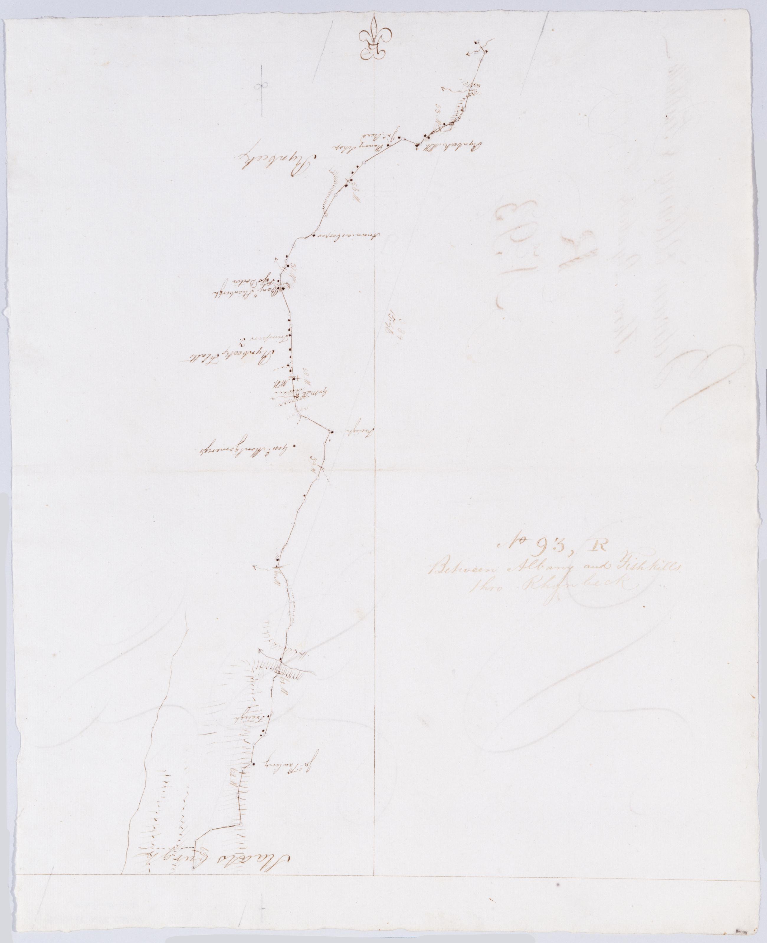
Cartographic Between Albany and Fishkills thro Rhynbeck. No 93, R / by Robert Erskine F.R.S. Geogr. A. U.S. and Assistants ; [P]r Simeon DeWitt. Foxed, creased and abraded. Mounted on cloth, bound, disbound and silked by subsequent owners. Cleaned after removal of backings 1999; some fill remains. Sheathed in mylar. In erased pencil on recto: "No 93 R". In ink on verso: "R R R". Military topographic map. Covers the townships of Red Hook, Rhinebeck and Hyde Park in Dutchess County, New York. Shows roads running through Rhinebeck and Staatsburg. Also shows buildings and owners' names, landforms and streams. Pen-and-ink, pencil on laid paper. Shows relief by hachures. View Item
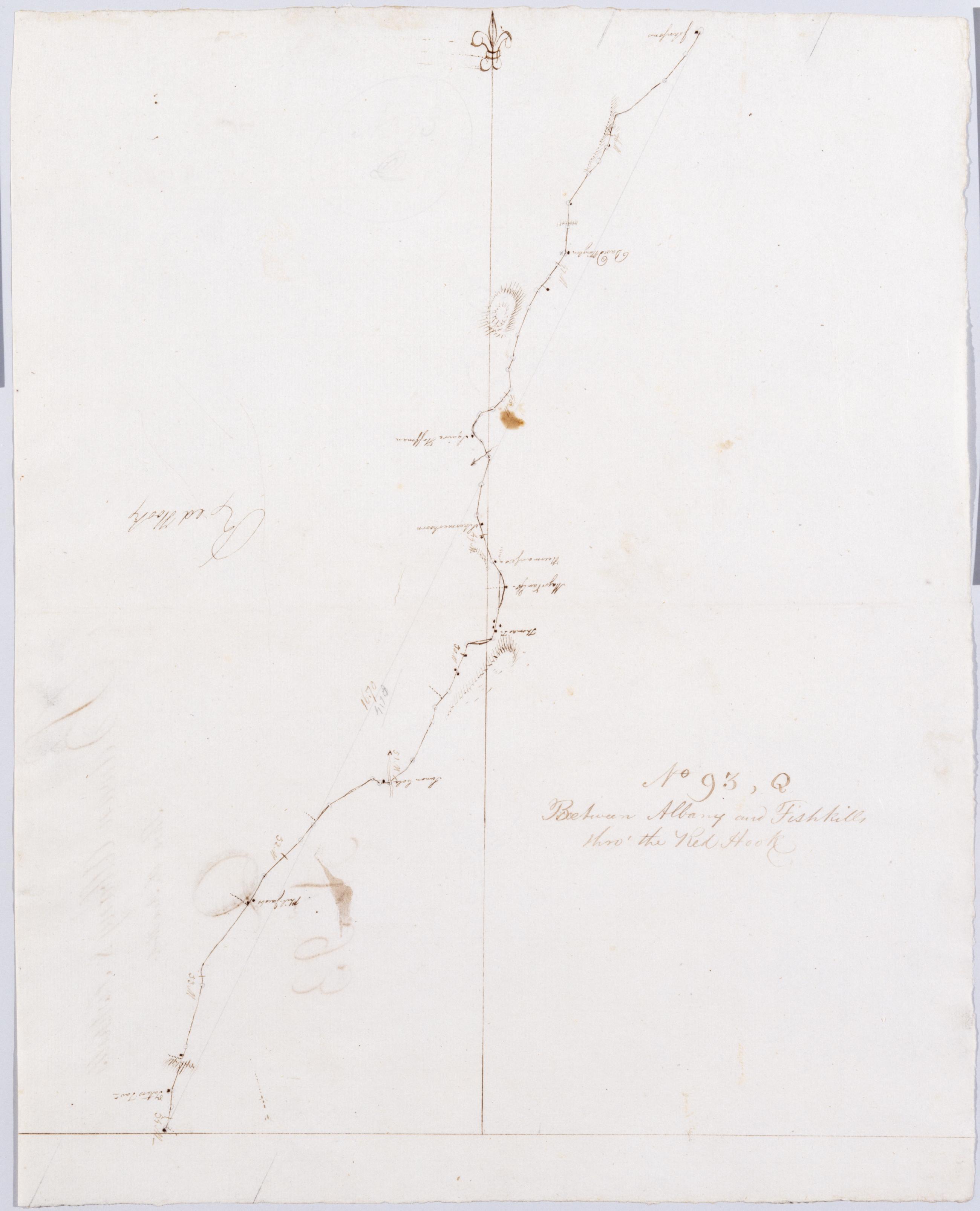
Cartographic Between Albany and Fishkills thro' the Red Hook. No 93, Q / by Robert Erskine F.R.S. Geogr. A. U.S. and Assistants. In erased pencil on recto: "No 93 Q". Military topographic map. Covers the townships of Clermont in Columbia County and Red Hook in Dutchess County, New York. Shows roads running through Clermont, Nevis, Upper Red Hook and Red Hook. Also shows buildings and owners' names, landforms and streams. Pen-and-ink, pencil on laid paper. Shows relief by hachures. Stained, soiled, creased and abraded. Mounted on cloth, bound, disbound and silked by subsequent owners. Cleaned after removal of backings 1999; some fill remains. Sheathed in mylar. View Item
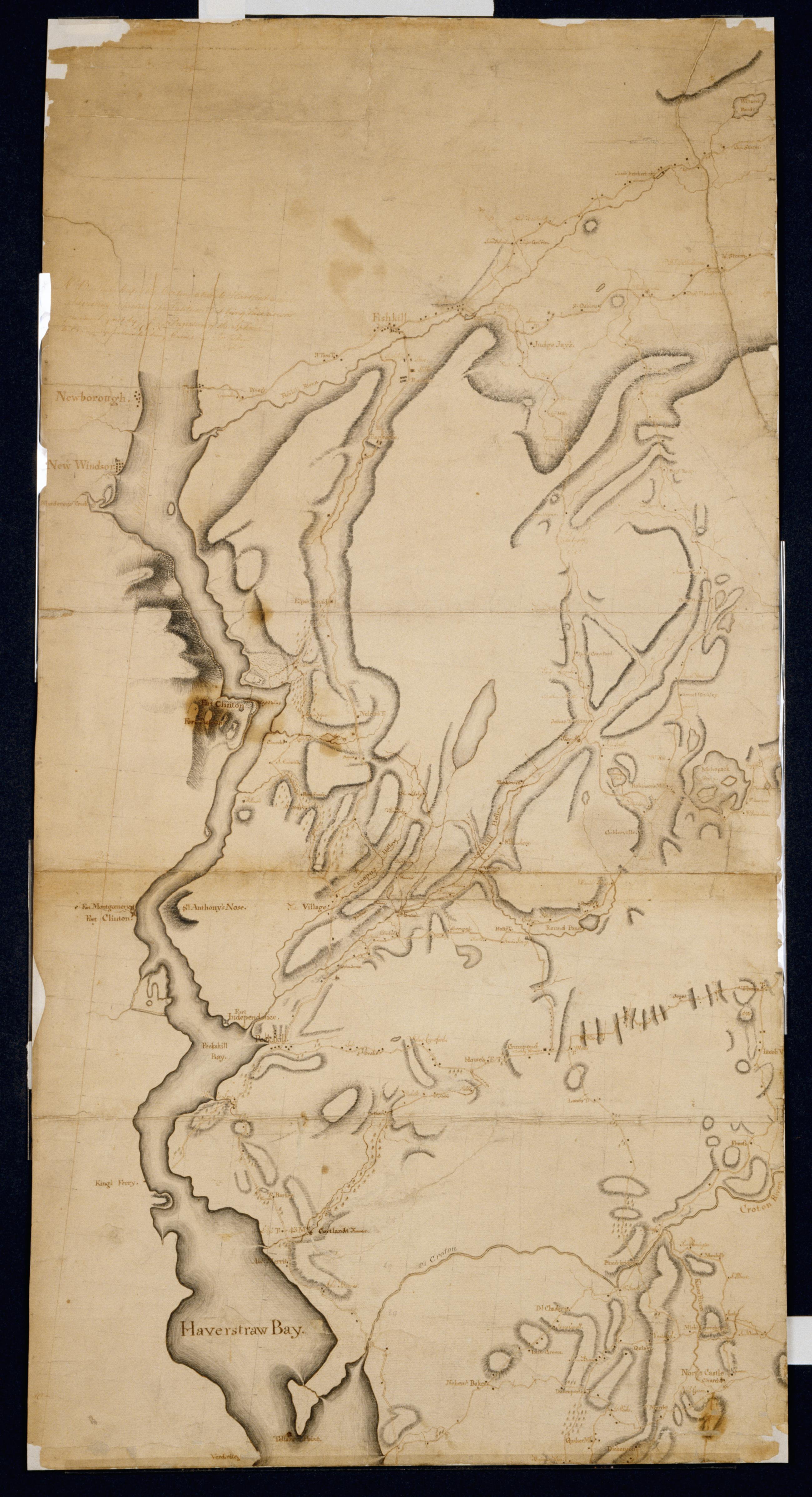
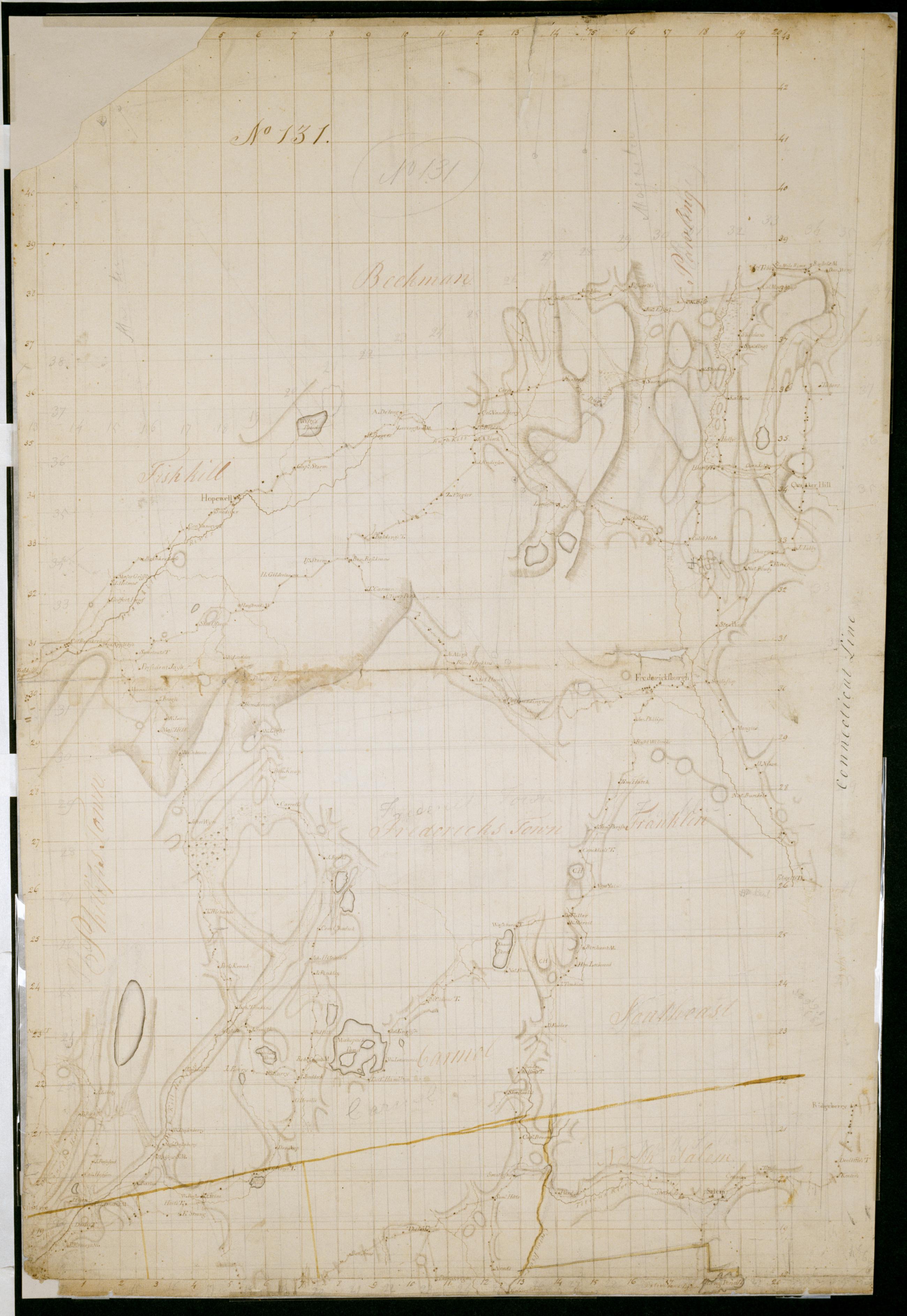
Cartographic [Map of roads in the area bounded by Peekskill and Fishkill (N.Y.), Quaker Hill and Ridgeberry (Conn.)] No 131 Attributed to Eskine by cataloger. Date based on attribution to Erskine. In pencil on recto: "No 131". Military topographic map. Covers the towns of Dover, Pawling, Beekman and East Fishkill in Dutchess County; of Phillipstown, Putnam Valley, Kent, Carmel, South East and Patterson in Putnam County; and of North Salem, Somers, Yorktown and Cortlandt in Westchester County, New York; also the town of Ridgefield in Fairfield County, Connecticut. Map shows buildings and owners' names, landforms and streams. Pen-and-ink, pencil on laid paper. Watercolor for some township boundary lines. View Item
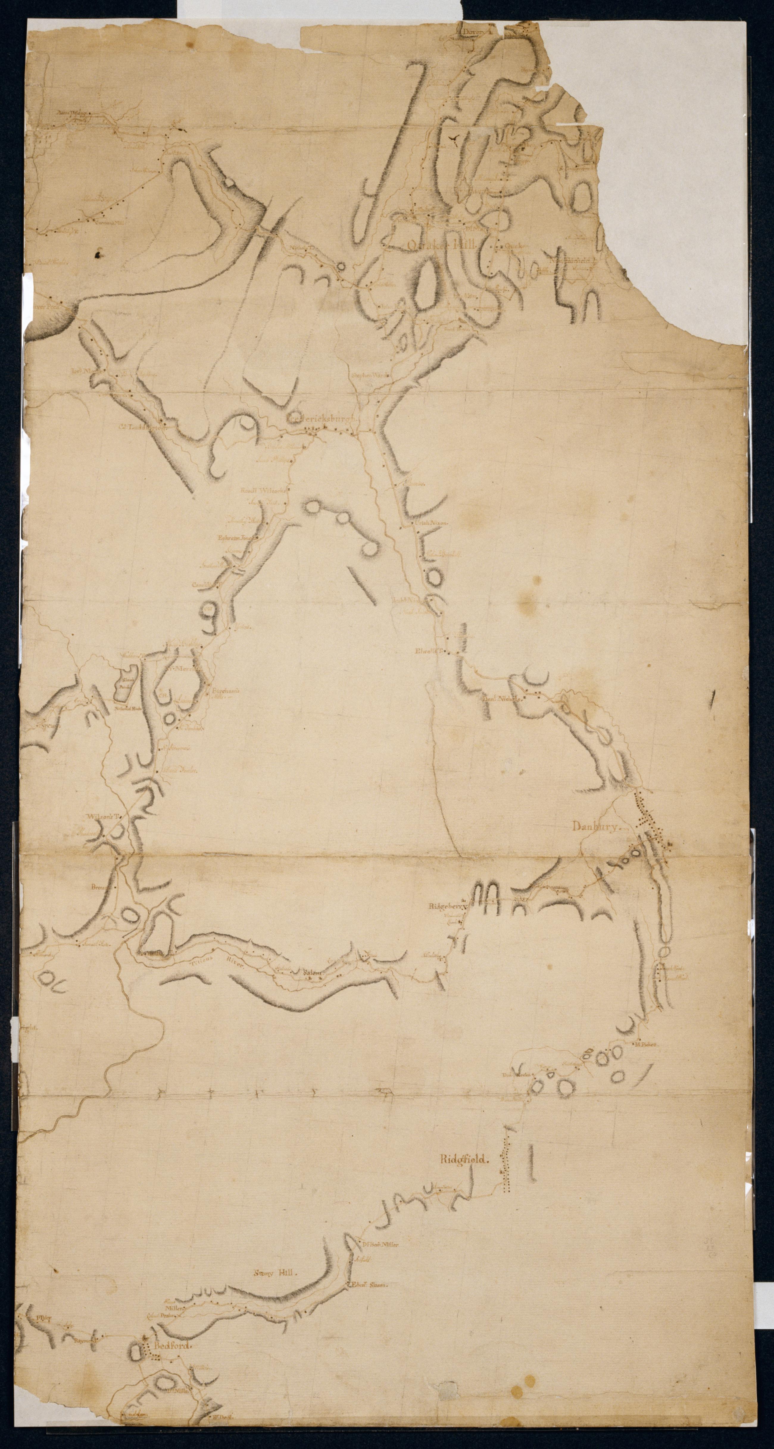
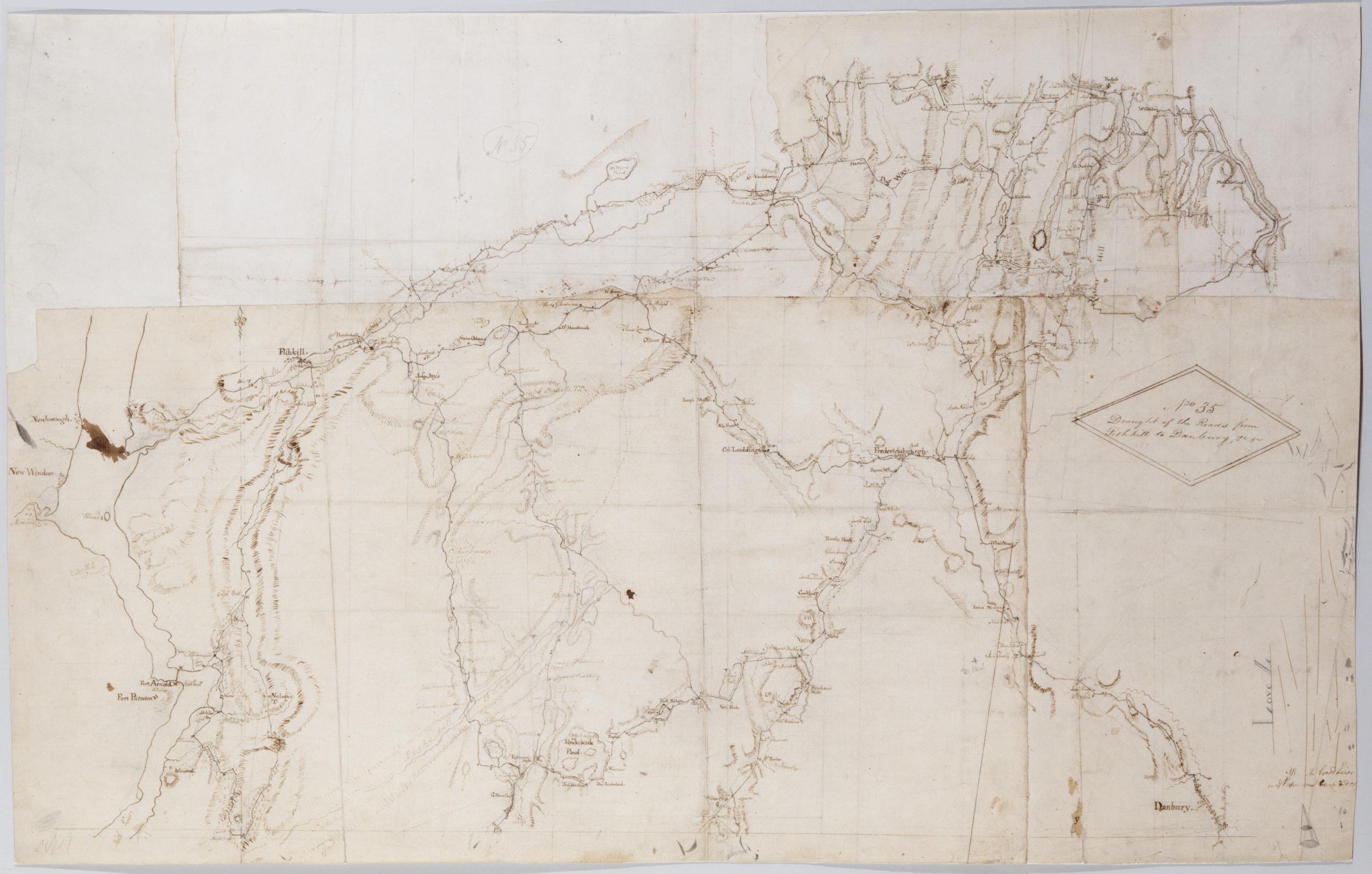
Cartographic Draught of the Roads from Fishkill to Danbury &c. &c. No 35 / by Robert Erskine F.R.S. Geogr. A. U.S. and Assistants. In pencil on recto: "No 35," "Love L". Military topographic map. Covers an area between the Hudson and Houstonic Rivers; i.e., most of Putnam and Dutchess Counties in New York, northern Fairfield County and part of Litchfield County in Connecticut. Shows roads, buildings and owners' names, also landforms and streams. Pen-and-ink, pencil on five pieces laid paper, assembled. Sixth piece at upper left has wove finish. Shows relief by hachures. Title proper from recto is the work of a later editor--Simeon DeWitt or his assign--subsequent to 1820. View Item
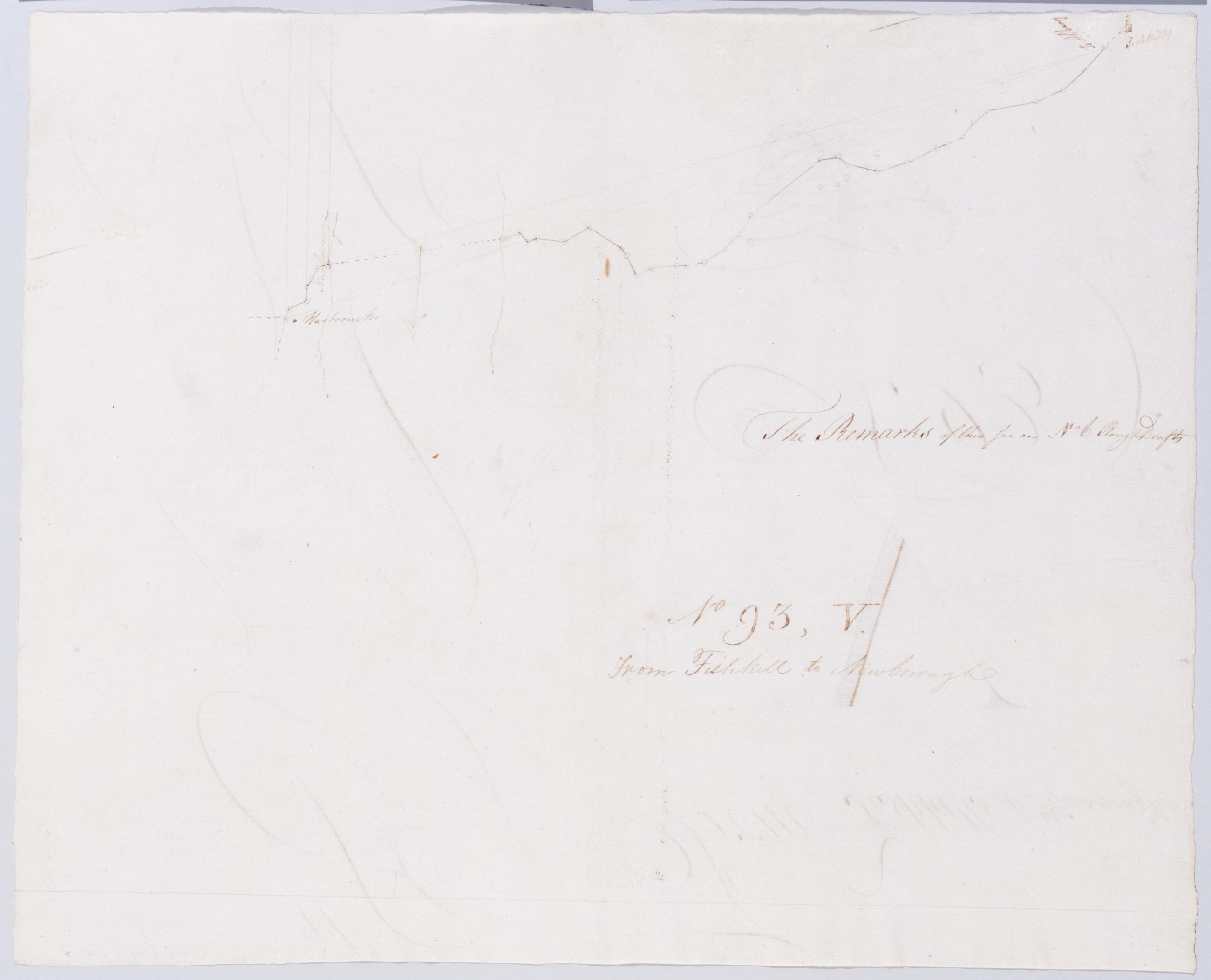
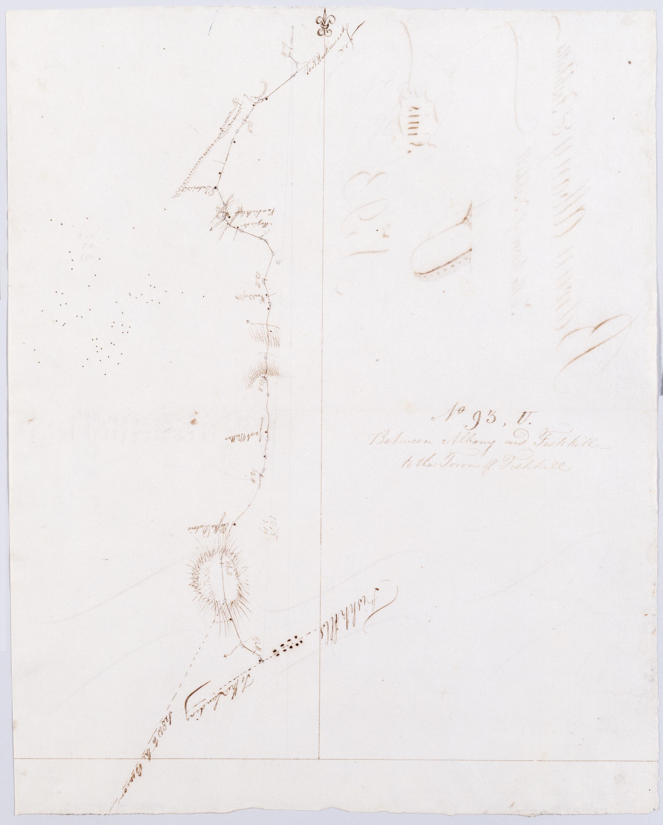
Cartographic From Fishkill to Newborough. No 93, V / by Robert Erskine F.R.S. Geogr. A. U.S. and Assistants. In ink on verso: lots of squiggles. In pencil on recto: "No 93 V". Includes text: "The Remarks of this See on No 6 Rough Drafts". Military topographic map. Covers the township of Fishkill in Dutchess County, New York. Shows roads running through Fishkill Village, Glenham, Groveville and Fishkill. Also shows buildings and owners' names, landforms and streams. Pen-and-ink, pencil on laid paper. Shows relief by hachures. Stained, creased and abraded. Mounted on cloth, bound, disbound and silked by subsequent owners. Cleaned after removal of backings 1999; some fill remains. Sheathed in mylar. View Item
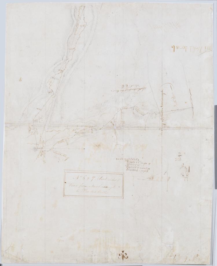
Cartographic Between Albany + Fishkill - to the Town of Fishkill. No 93, U / by Robert Erskine F.R.S. Geogr. A. U.S. and Assistants. Foxed, stained, creased and abraded. Mounted on cloth, cropped and bound, disbound and silked by subsequent owners. Cleaned after removal of backings 1999; some fill remains. Sheathed in mylar. In ink on verso: "U U U" and "Finis". In pencil on recto: "No 93 U". Military topographic map. Covers the townships of Poughkeepsie, Wappinger and Fishkill in Dutchess County, New York. Shows roads running through Channingville, Wappinger Falls and Fishkill Village. Also shows buildings and owners' names, landforms and streams. Pen-and-ink, pencil on laid paper. Shows relief by hachures. View Item
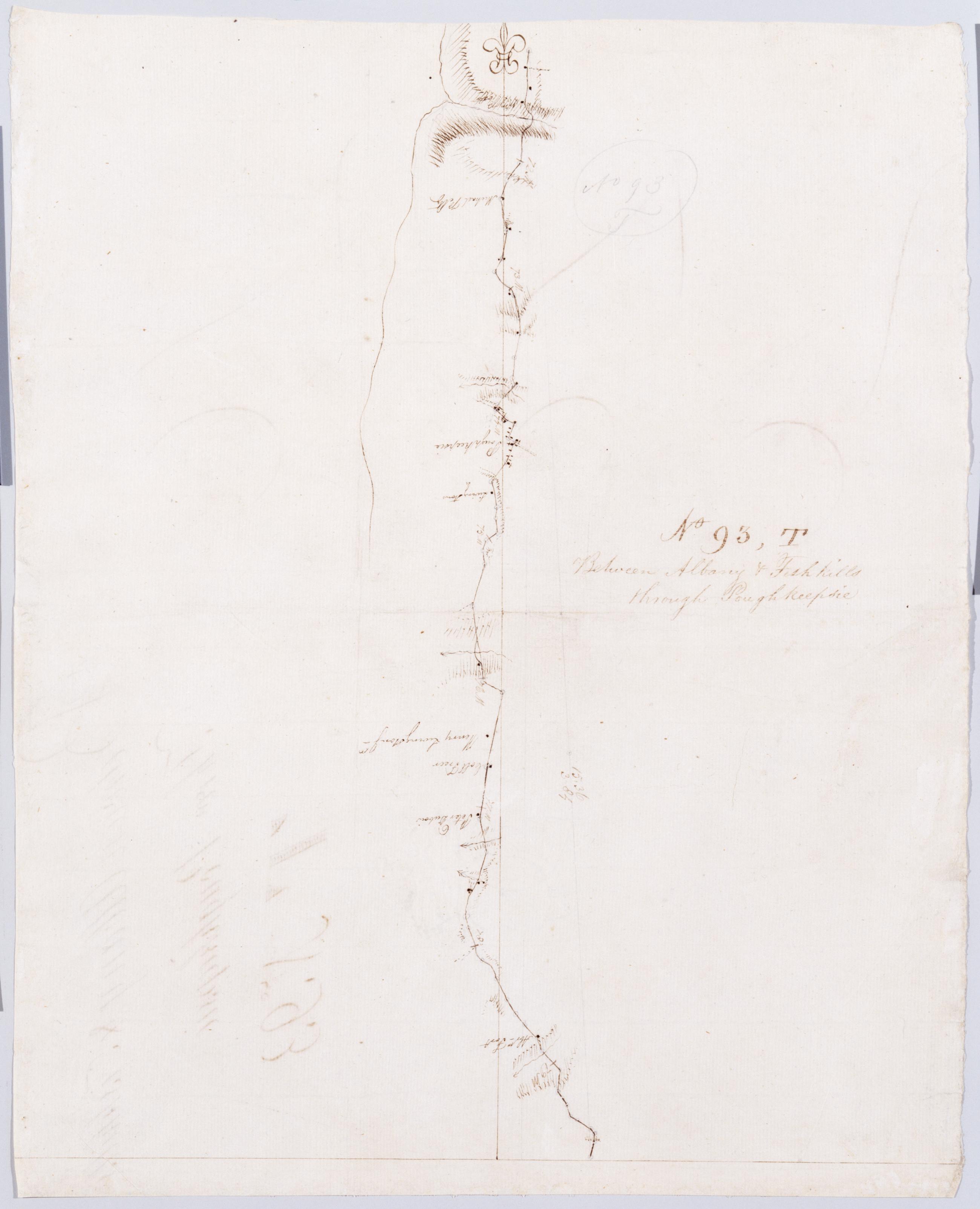
Cartographic Between Albany + Fishkills through Poughkeepsie. No 93, T / by Robert Erskine F.R.S. Geogr. A. U.S. and Assistants. Foxed, soiled, creased and abraded. Mounted on cloth, cropped and bound, disbound and silked by subsequent owners. Cleaned after removal of backings 1999; some fill remains. Sheathed in mylar. In ink on verso: "T T T". In pencil on recto: "No 93 T". Military topographic map. Covers the township of Hyde Park and Poughkeepsie in Dutchess County, New York. Shows roads running through Poughkeepsie. Also shows buildings and owners' names, landforms and streams. Pen-and-ink, pencil on laid paper. Shows relief by hachures. View Item
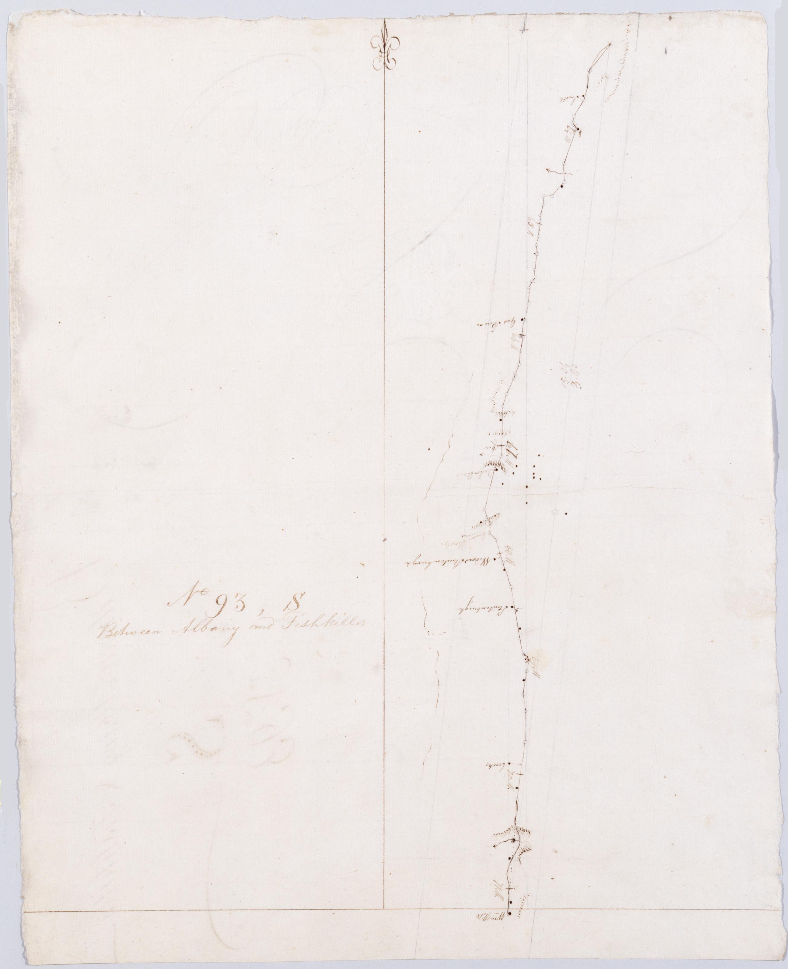
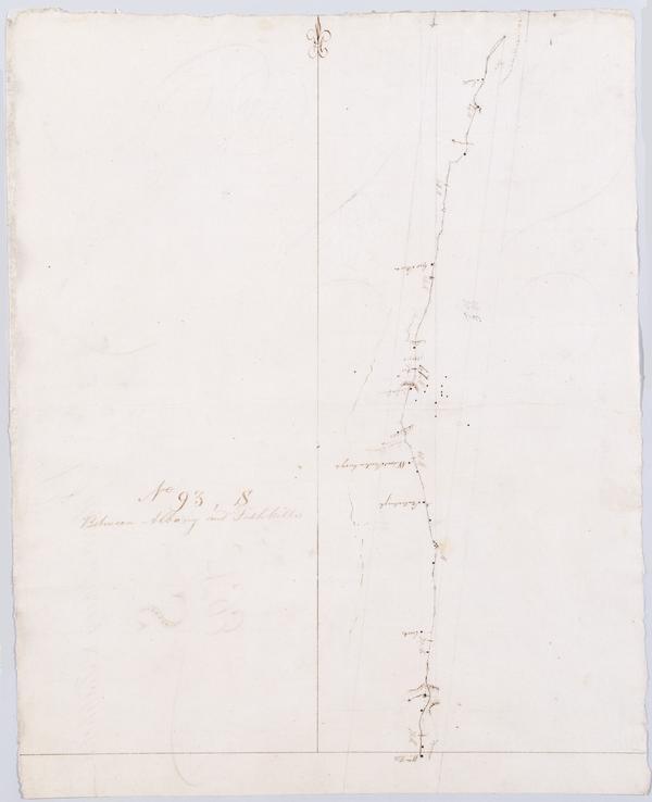
Cartographic Between Albany and Fishkills. No 93, S / by Robert Erskine F.R.S. Geogr. A. U.S. and Assistants. In erased pencil on recto: "No 93 S". In ink on verso: "S S S". Military topographic map. Covers the township of Hyde Park in Dutchess County, New York. Shows roads running through Staatsburg and Hyde Park. Also shows buildings and owners' names, landforms and streams. Pen-and-ink, pencil on laid paper. Shows relief by hachures. Stained, soiled, creased and abraded. Mounted on cloth, bound, disbound and silked by subsequent owners. Cleaned after removal of backings 1999; some fill remains. Sheathed in mylar. View Item
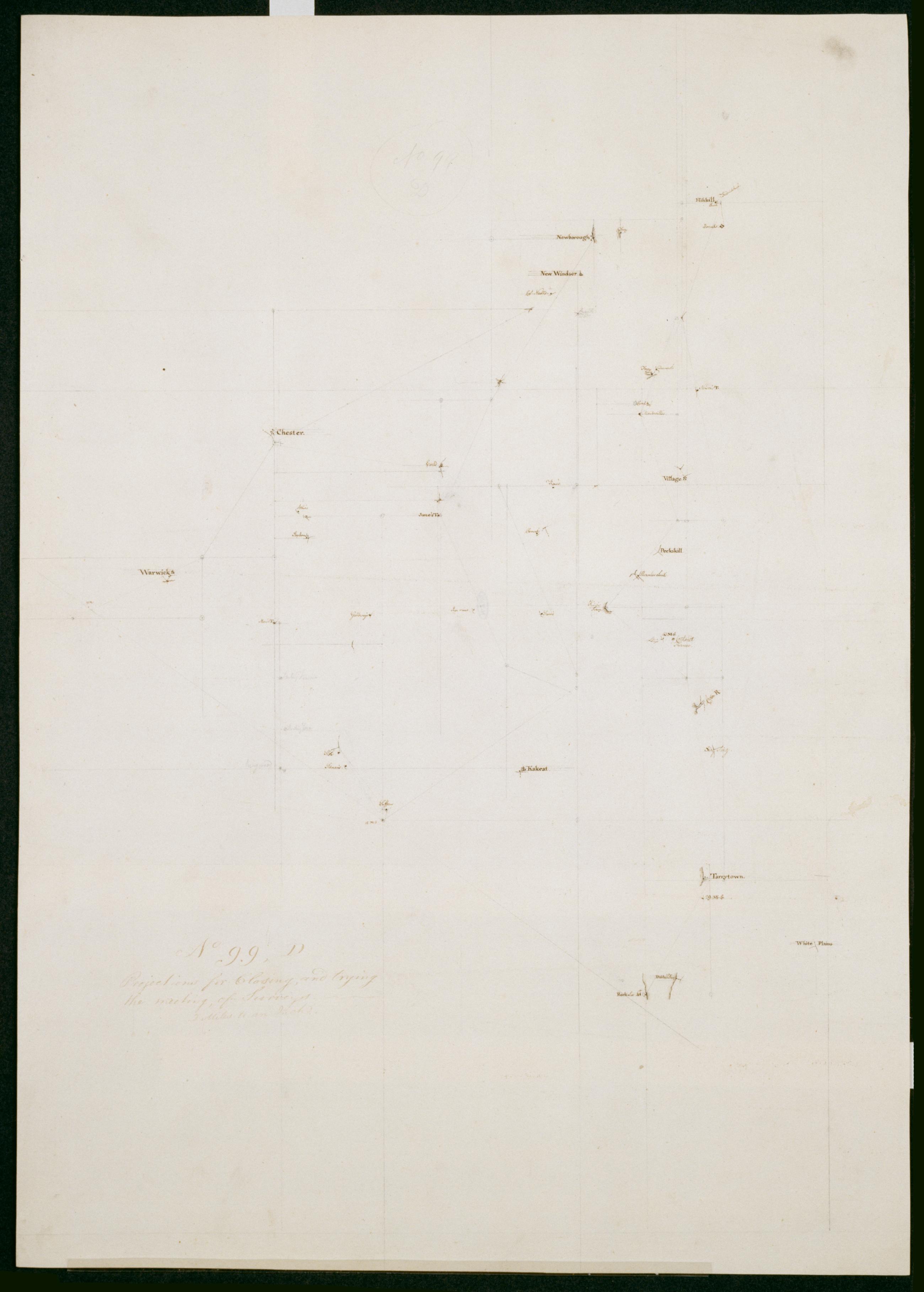
Cartographic Projections for Closing, and trying the meeting of Surveys. No 99, D / Large paper by Capt. Scull ; by Robert Erskine F.R.S. Geogr. A. U.S. and Assistants. In ink on verso: "No. 99 D". In pencil on recto: "No 99 D". Military topographic map; an early draft. Covers Dutchess, Orange, Putnam, Rockland and Westchester counties in New York. Pen-and-ink, pencil on laid paper. Soiled, creased and abraded. Mounted on cloth, bound and cropped, disbound and silked by subsequent owners. Cleaned after removal of backings 1999; some fill remains. Sheathed in mylar. Title proper from recto is the work of a later editor--Simeon DeWitt or his assign--subsequent to 1820. View Item
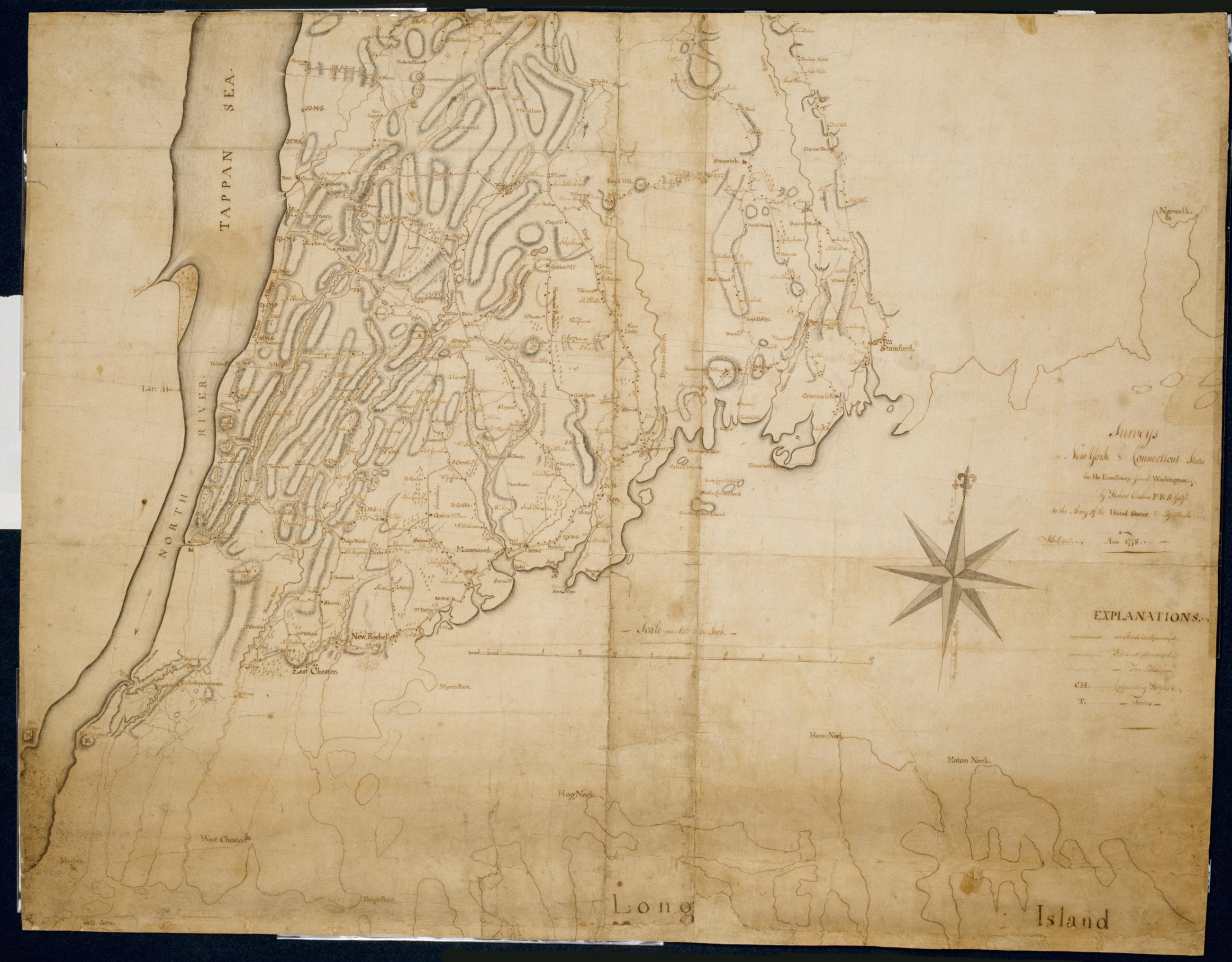
Cartographic Surveys in New York & Connecticut States for His Excellency General Washington : Anno 1778 by Robert Erskine F.R.S. Geogr: to the Army of the United States & Assistants ; W Scull delint., first fragment Has projection grid in faint pencil. Imperfect: lacks 19 x 12 at upper right corner and 3 x 8 cm. at center. Minor losses along frayed top and left edge. Military topographic map; not listed in Heusser nor Guthorn. Covers the counties of Fairfield in Connecticut and of Dutchess, Putnam and Westchester in New York; New York City and the northern shore of Long Island are also shown, but with less detail. Shows some buildings and owners' names, landforms and streams. Pen-and-ink, pencil on laid paper. View Item
Cartographic Surveys in New York & Connecticut States for His Excellency General Washington : Anno 1778 by Robert Erskine F.R.S. Geogr: to the Army of the United States & Assistants ; W Scull delint., third fragment Has projection grid in faint pencil. Imperfect: lacks 19 x 12 at upper right corner and 3 x 8 cm. at center. Minor losses along frayed top and left edge. Military topographic map; not listed in Heusser nor Guthorn. Covers the counties of Fairfield in Connecticut and of Dutchess, Putnam and Westchester in New York; New York City and the northern shore of Long Island are also shown, but with less detail. Shows some buildings and owners' names, landforms and streams. Pen-and-ink, pencil on laid paper. View Item
Cartographic Surveys in New York & Connecticut States for His Excellency General Washington : Anno 1778 by Robert Erskine F.R.S. Geogr: to the Army of the United States & Assistants ; W Scull delint., second fragment Has projection grid in faint pencil. Imperfect: lacks 19 x 12 at upper right corner and 3 x 8 cm. at center. Minor losses along frayed top and left edge. Military topographic map; not listed in Heusser nor Guthorn. Covers the counties of Fairfield in Connecticut and of Dutchess, Putnam and Westchester in New York; New York City and the northern shore of Long Island are also shown, but with less detail. Shows some buildings and owners' names, landforms and streams. Pen-and-ink, pencil on laid paper. View Item
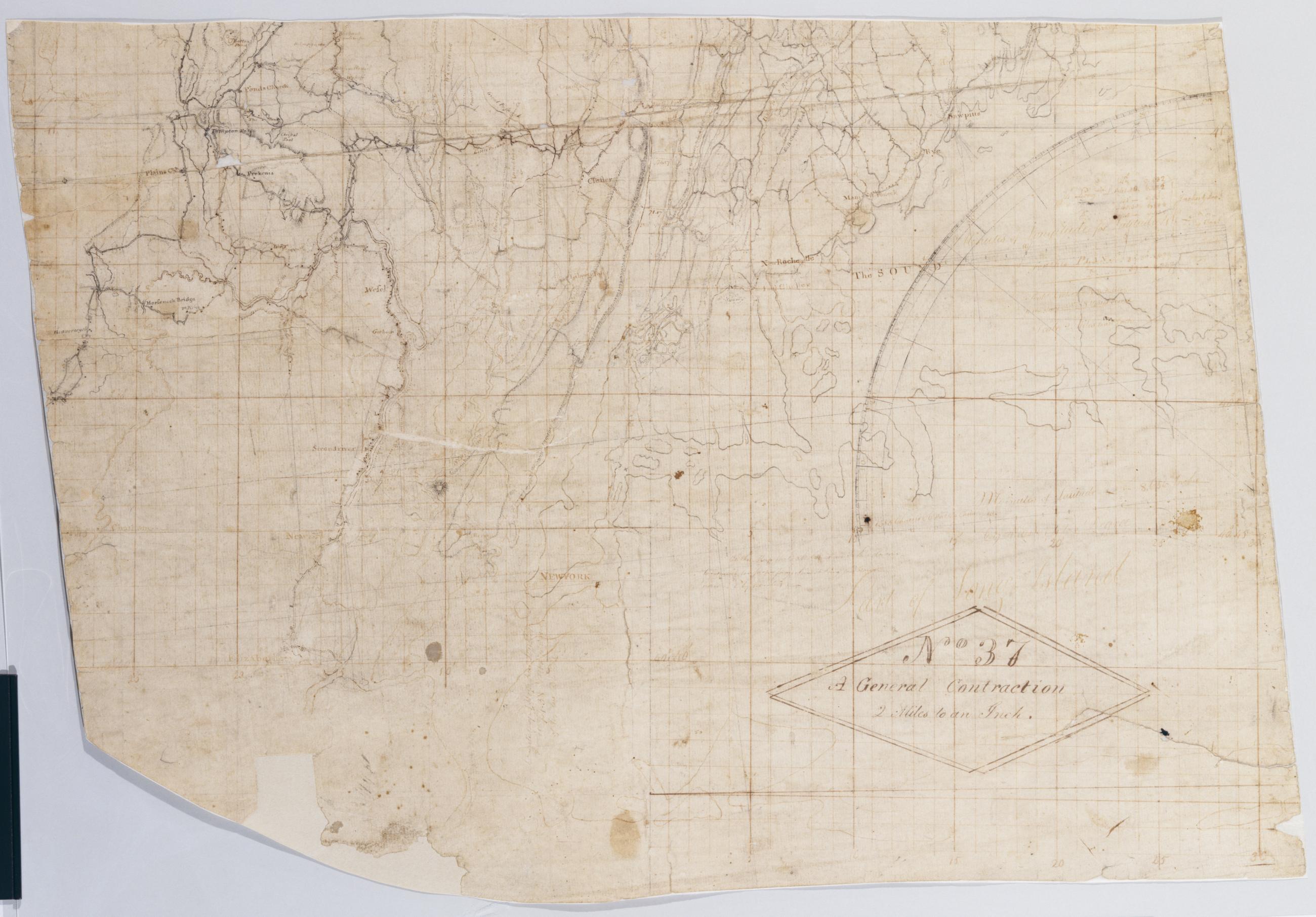
Cartographic A General Contraction 2 Miles to an Inch. No 37 / by R.E. ; by Robert Erskine F.R.S. Geogr. A. U.S. and Assistants, bottom Military topographic map. Covers the lower Hudson River Valley in New York, New Jersey and Connecticut, from Warwick (N.Y.) and Pompton Plains (N.J.) to New Milford and Danbury (Conn.), and from Newburgh (N.Y.) to Staten Island (N.Y.). Shows roads, buildings and owners' names, also landforms and streams. Shows relief by hachures. Title proper from recto is the work of a later editor--Simeon DeWitt or his assign--subsequent to 1820. Index title, both statements of responsibility, date, series title and series numbering by Erskine, but on separate index sheet filed at head of series. View Item
Cartographic A General Contraction 2 Miles to an Inch. No 37 / by R.E. ; by Robert Erskine F.R.S. Geogr. A. U.S. and Assistants, top Military topographic map. Covers the lower Hudson River Valley in New York, New Jersey and Connecticut, from Warwick (N.Y.) and Pompton Plains (N.J.) to New Milford and Danbury (Conn.), and from Newburgh (N.Y.) to Staten Island (N.Y.). Shows roads, buildings and owners' names, also landforms and streams. Shows relief by hachures. Title proper from recto is the work of a later editor--Simeon DeWitt or his assign--subsequent to 1820. Index title, both statements of responsibility, date, series title and series numbering by Erskine, but on separate index sheet filed at head of series. View Item
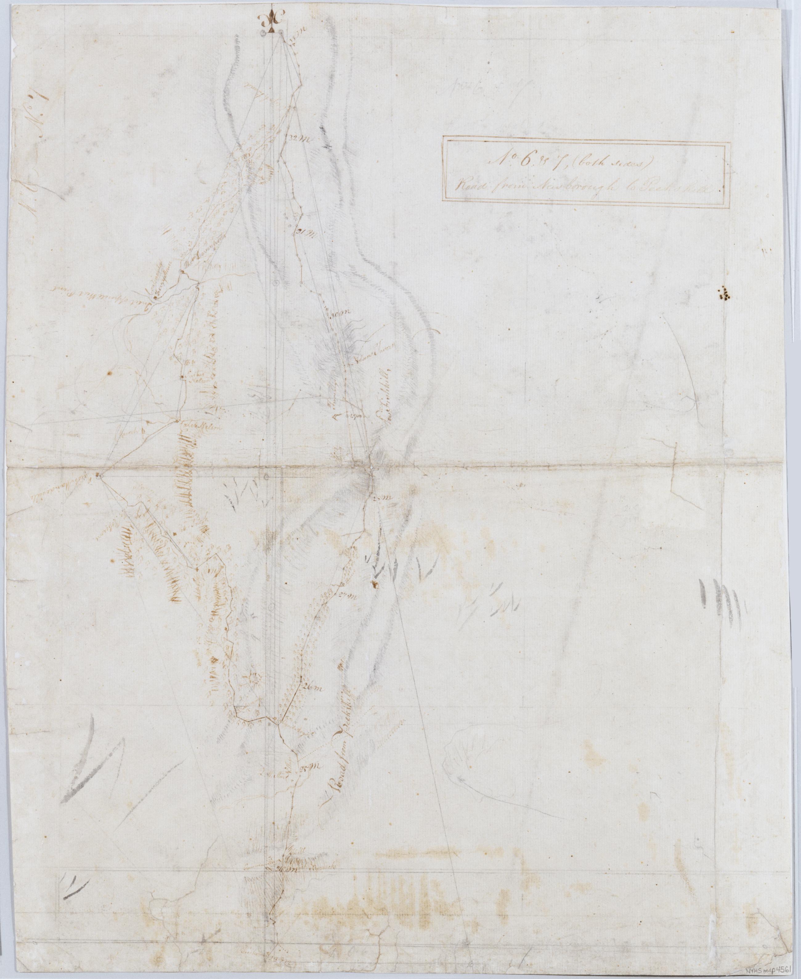
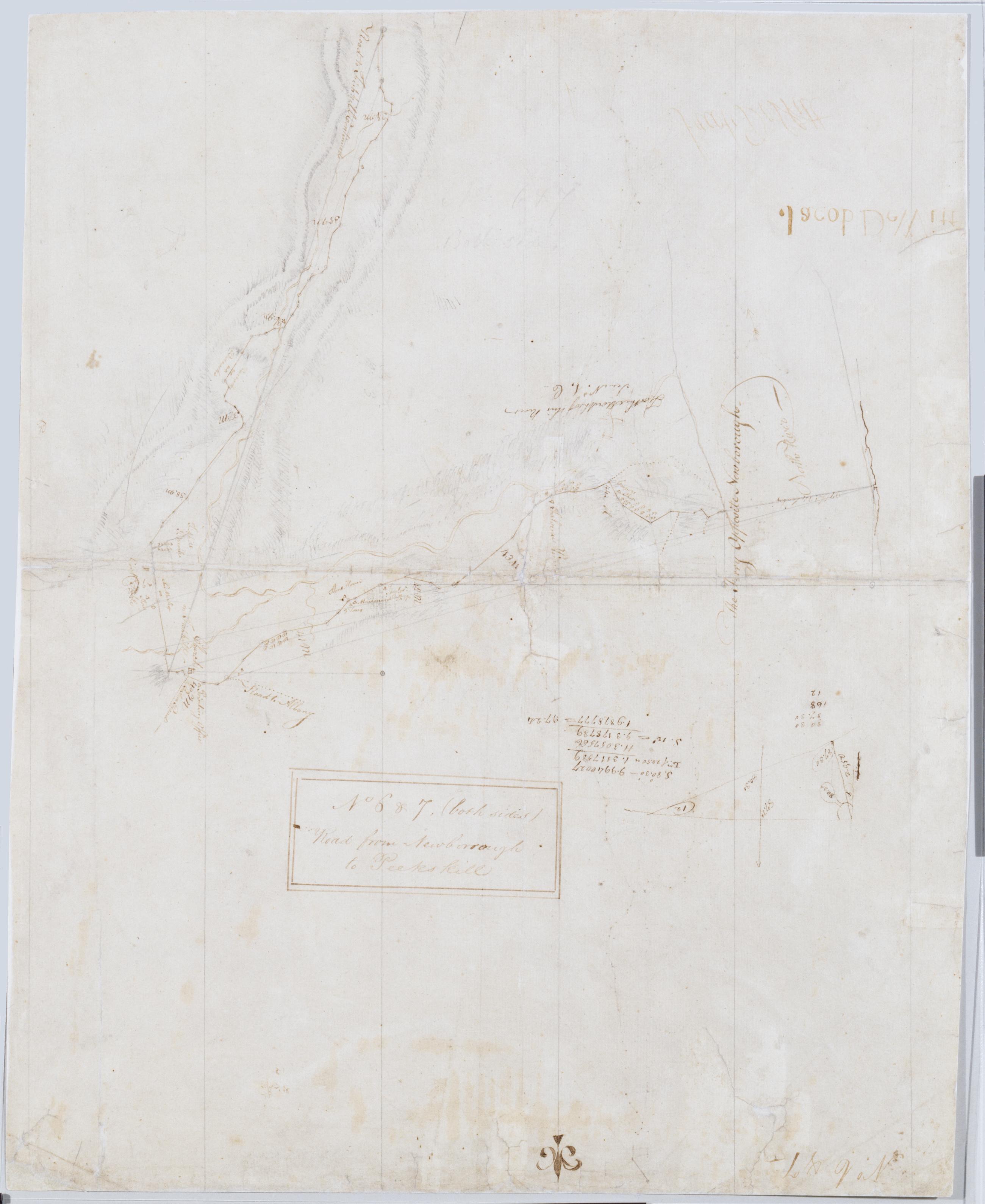
Cartographic Road from Newborough to Peeks kill. No. 6. & 7 (both sides) ; Road from Newborrough to Peeks kill. No. 6 & 7, (both sides) / by Robert Erskine F.R.S. Geogr. A. U.S. and Assistants, verso [no. 7] Frayed, creased, foxed and abraded. Mounted on cloth, bound and cropped, disbound, silked by later owners. Cleaned after removal of backings 1999. Sheathed in mylar. In ink on recto, but in reverse writing: "Jacob DeWitt" (printed), "Jacob DeWitt" (signature). In ink on recto: "No. 6 - No. 7". In ink on verso: "No. 6 + 7". Maps show relief by hachures. Military topographic maps. Maps cover the towns of Fishkill and Phillipstown in Putnam County and of Peekskill in Westchester County, New York. View Item
Cartographic Road from Newborough to Peeks kill. No. 6. & 7 (both sides) ; Road from Newborrough to Peeks kill. No. 6 & 7, (both sides) / by Robert Erskine F.R.S. Geogr. A. U.S. and Assistants, recto [no. 6] Frayed, creased, foxed and abraded. Mounted on cloth, bound and cropped, disbound, silked by later owners. Cleaned after removal of backings 1999. Sheathed in mylar. In ink on recto, but in reverse writing: "Jacob DeWitt" (printed), "Jacob DeWitt" (signature). In ink on recto: "No. 6 - No. 7". In ink on verso: "No. 6 + 7". Maps show relief by hachures. Military topographic maps. Maps cover the towns of Fishkill and Phillipstown in Putnam County and of Peekskill in Westchester County, New York. View Item
Image Cartographic 3 Items Surveys in New York & Connecticut States for His Excellency General Washington : Anno 1778 by Robert Erskine F.R.S. Geogr: to the Army of the United States & Assistants ; W Scull delint. Has projection grid in faint pencil. Imperfect: lacks 19 x 12 at upper right corner and 3 x 8 cm. at center. Minor losses along frayed top and left edge. Military topographic map; not listed in Heusser nor Guthorn. Covers the counties of Fairfield in Connecticut and of Dutchess, Putnam and Westchester in New York; New York City and the northern shore of Long Island are also shown, but with less detail. Shows some buildings and owners' names, landforms and streams. Pen-and-ink, pencil on laid paper. View Item
Image Cartographic 2 Items A General Contraction 2 Miles to an Inch. No 37 / by R.E. ; by Robert Erskine F.R.S. Geogr. A. U.S. and Assistants. Military topographic map. Covers the lower Hudson River Valley in New York, New Jersey and Connecticut, from Warwick (N.Y.) and Pompton Plains (N.J.) to New Milford and Danbury (Conn.), and from Newburgh (N.Y.) to Staten Island (N.Y.). Shows roads, buildings and owners' names, also landforms and streams. Shows relief by hachures. Title proper from recto is the work of a later editor--Simeon DeWitt or his assign--subsequent to 1820. Index title, both statements of responsibility, date, series title and series numbering by Erskine, but on separate index sheet filed at head of series. View Item
Image Cartographic 2 Items Road from Newborough to Peeks kill. No. 6. & 7 (both sides) ; Road from Newborrough to Peeks kill. No. 6 & 7, (both sides) / by Robert Erskine F.R.S. Geogr. A. U.S. and Assistants. Frayed, creased, foxed and abraded. Mounted on cloth, bound and cropped, disbound, silked by later owners. Cleaned after removal of backings 1999. Sheathed in mylar. In ink on recto, but in reverse writing: "Jacob DeWitt" (printed), "Jacob DeWitt" (signature). In ink on recto: "No. 6 - No. 7". In ink on verso: "No. 6 + 7". Maps show relief by hachures. Military topographic maps. Maps cover the towns of Fishkill and Phillipstown in Putnam County and of Peekskill in Westchester County, New York. View Item
Cartographic Between Albany and Fishkills thro Rhynbeck. No 93 R / by Robert Erskine F.R.S. Geogr. A. U.S. and Assistants ; [P]r Simeon DeWitt. Foxed- creased and abraded. Mounted on cloth- bound- disbound and silked by subsequent owners. Cleaned after removal of backings 1999; some fill remains. Sheathed in mylar. In erased pencil on recto: "No 93 R". In ink on verso: "R R R". Military topographic map. Covers the townships of Red Hook- Rhinebeck and Hyde Park in Dutchess County- New York. Shows roads running through Rhinebeck and Staatsburg. Also shows buildings and owners' names- landforms and streams. Pen-and-ink- pencil on laid paper. Shows relief by hachures. View Item
Cartographic Between Albany and Fishkills thro' the Red Hook. No 93 Q / by Robert Erskine F.R.S. Geogr. A. U.S. and Assistants. In erased pencil on recto: "No 93 Q". Military topographic map. Covers the townships of Clermont in Columbia County and Red Hook in Dutchess County- New York. Shows roads running through Clermont- Nevis- Upper Red Hook and Red Hook. Also shows buildings and owners' names- landforms and streams. Pen-and-ink- pencil on laid paper. Shows relief by hachures. Stained- soiled- creased and abraded. Mounted on cloth- bound- disbound and silked by subsequent owners. Cleaned after removal of backings 1999; some fill remains. Sheathed in mylar. View Item
Cartographic [Map of roads in the area bounded by Peekskill and Fishkill (N.Y.) Quaker Hill and Ridgeberry (Conn.)] No 131 Attributed to Eskine by cataloger. Date based on attribution to Erskine. In pencil on recto: "No 131". Military topographic map. Covers the towns of Dover- Pawling- Beekman and East Fishkill in Dutchess County; of Phillipstown- Putnam Valley- Kent- Carmel- South East and Patterson in Putnam County; and of North Salem- Somers- Yorktown and Cortlandt in Westchester County- New York; also the town of Ridgefield in Fairfield County- Connecticut. Map shows buildings and owners' names- landforms and streams. Pen-and-ink- pencil on laid paper. Watercolor for some township boundary lines. View Item
Cartographic Draught of the Roads from Fishkill to Danbury &c. &c. No 35 / by Robert Erskine F.R.S. Geogr. A. U.S. and Assistants. In pencil on recto: "No 35-" "Love L". Military topographic map. Covers an area between the Hudson and Houstonic Rivers; i.e.- most of Putnam and Dutchess Counties in New York- northern Fairfield County and part of Litchfield County in Connecticut. Shows roads- buildings and owners' names- also landforms and streams. Pen-and-ink- pencil on five pieces laid paper- assembled. Sixth piece at upper left has wove finish. Shows relief by hachures. Title proper from recto is the work of a later editor--Simeon DeWitt or his assign--subsequent to 1820. View Item
Cartographic From Fishkill to Newborough. No 93 V / by Robert Erskine F.R.S. Geogr. A. U.S. and Assistants. In ink on verso: lots of squiggles. In pencil on recto: "No 93 V". Includes text: "The Remarks of this See on No 6 Rough Drafts". Military topographic map. Covers the township of Fishkill in Dutchess County- New York. Shows roads running through Fishkill Village- Glenham- Groveville and Fishkill. Also shows buildings and owners' names- landforms and streams. Pen-and-ink- pencil on laid paper. Shows relief by hachures. Stained- creased and abraded. Mounted on cloth- bound- disbound and silked by subsequent owners. Cleaned after removal of backings 1999; some fill remains. Sheathed in mylar. View Item
Cartographic Between Albany + Fishkill - to the Town of Fishkill. No 93 U / by Robert Erskine F.R.S. Geogr. A. U.S. and Assistants. Foxed- stained- creased and abraded. Mounted on cloth- cropped and bound- disbound and silked by subsequent owners. Cleaned after removal of backings 1999; some fill remains. Sheathed in mylar. In ink on verso: "U U U" and "Finis". In pencil on recto: "No 93 U". Military topographic map. Covers the townships of Poughkeepsie- Wappinger and Fishkill in Dutchess County- New York. Shows roads running through Channingville- Wappinger Falls and Fishkill Village. Also shows buildings and owners' names- landforms and streams. Pen-and-ink- pencil on laid paper. Shows relief by hachures. View Item
Cartographic Between Albany + Fishkills through Poughkeepsie. No 93 T / by Robert Erskine F.R.S. Geogr. A. U.S. and Assistants. Foxed- soiled- creased and abraded. Mounted on cloth- cropped and bound- disbound and silked by subsequent owners. Cleaned after removal of backings 1999; some fill remains. Sheathed in mylar. In ink on verso: "T T T". In pencil on recto: "No 93 T". Military topographic map. Covers the township of Hyde Park and Poughkeepsie in Dutchess County- New York. Shows roads running through Poughkeepsie. Also shows buildings and owners' names- landforms and streams. Pen-and-ink- pencil on laid paper. Shows relief by hachures. View Item
Cartographic Between Albany and Fishkills. No 93 S / by Robert Erskine F.R.S. Geogr. A. U.S. and Assistants. In erased pencil on recto: "No 93 S". In ink on verso: "S S S". Military topographic map. Covers the township of Hyde Park in Dutchess County- New York. Shows roads running through Staatsburg and Hyde Park. Also shows buildings and owners' names- landforms and streams. Pen-and-ink- pencil on laid paper. Shows relief by hachures. Stained- soiled- creased and abraded. Mounted on cloth- bound- disbound and silked by subsequent owners. Cleaned after removal of backings 1999; some fill remains. Sheathed in mylar. View Item
Cartographic Projections for Closing and trying the meeting of Surveys. No 99 D / Large paper by Capt. Scull ; by Robert Erskine F.R.S. Geogr. A. U.S. and Assistants. In ink on verso: "No. 99 D". In pencil on recto: "No 99 D". Military topographic map; an early draft. Covers Dutchess- Orange- Putnam- Rockland and Westchester counties in New York. Pen-and-ink- pencil on laid paper. Soiled- creased and abraded. Mounted on cloth- bound and cropped- disbound and silked by subsequent owners. Cleaned after removal of backings 1999; some fill remains. Sheathed in mylar. Title proper from recto is the work of a later editor--Simeon DeWitt or his assign--subsequent to 1820. View Item
Cartographic Surveys in New York & Connecticut States for His Excellency General Washington : Anno 1778 by Robert Erskine F.R.S. Geogr: to the Army of the United States & Assistants ; W Scull delint. Has projection grid in faint pencil. Imperfect: lacks 19 x 12 at upper right corner and 3 x 8 cm. at center. Minor losses along frayed top and left edge. Military topographic map; not listed in Heusser nor Guthorn. Covers the counties of Fairfield in Connecticut and of Dutchess- Putnam and Westchester in New York; New York City and the northern shore of Long Island are also shown- but with less detail. Shows some buildings and owners' names- landforms and streams. Pen-and-ink- pencil on laid paper. View Item
Cartographic A General Contraction 2 Miles to an Inch. No 37 / by R.E. ; by Robert Erskine F.R.S. Geogr. A. U.S. and Assistants. Military topographic map. Covers the lower Hudson River Valley in New York- New Jersey and Connecticut- from Warwick (N.Y.) and Pompton Plains (N.J.) to New Milford and Danbury (Conn.)- and from Newburgh (N.Y.) to Staten Island (N.Y.). Shows roads- buildings and owners' names- also landforms and streams. Shows relief by hachures. Title proper from recto is the work of a later editor--Simeon DeWitt or his assign--subsequent to 1820. Index title- both statements of responsibility- date- series title and series numbering by Erskine- but on separate index sheet filed at head of series. View Item