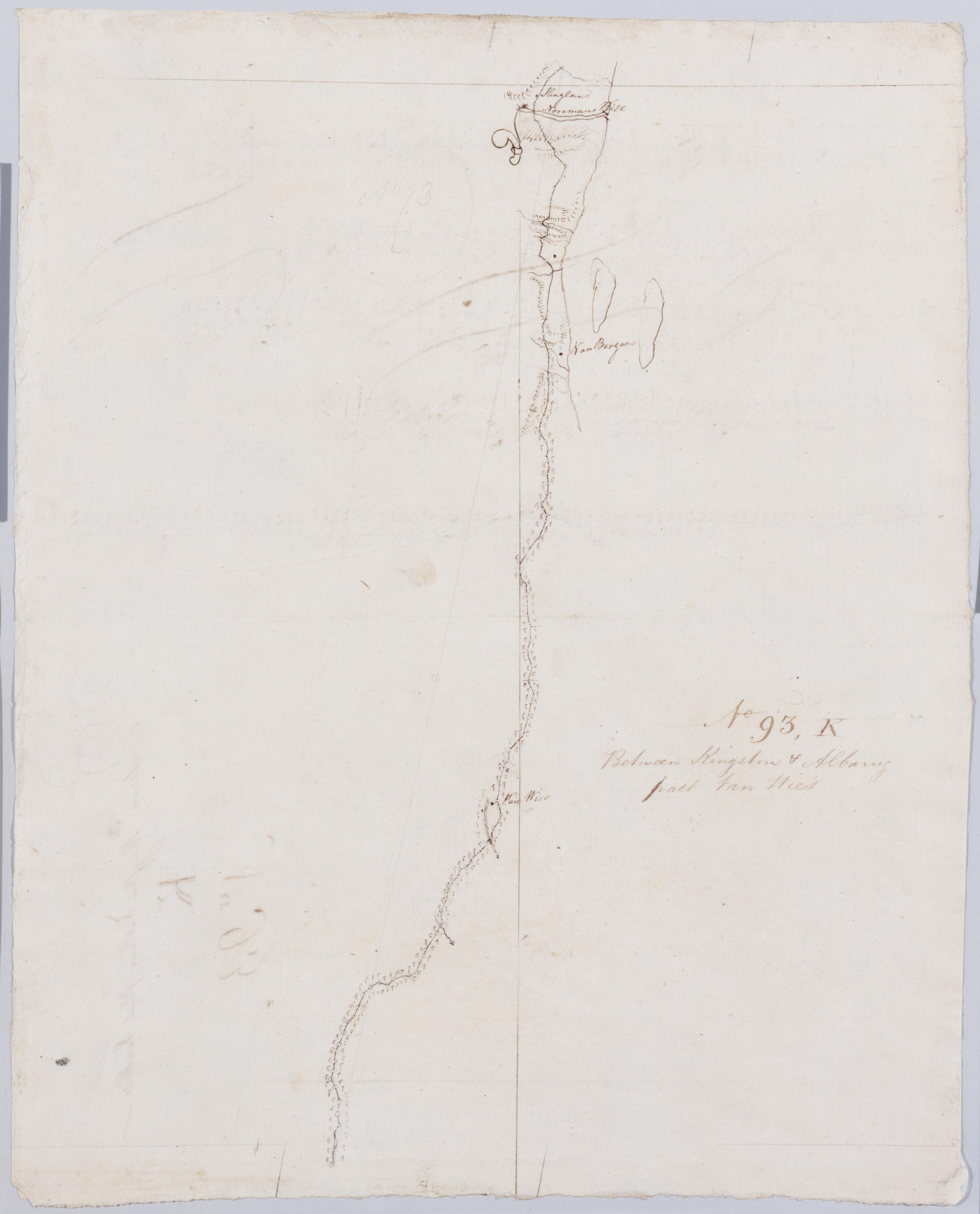
Cartographic Between Kingston + Albany past Van Wie's. No 93, K / by Robert Erskine F.R.S. Geogr. A. U.S. and Assistants. Foxed, stained, soiled, creased and abraded. Mounted on cloth, bound and cropped, disbound and silked by subsequent owners. Cleaned after removal of backings 1999; some fill remains. Sheathed in mylar. In ink on verso: "K K K". In pencil on recto: "No 93 K". Military topographic map. Covers the townships of Coeyman and Bethlehem in Albany County, New York. Shows roads running through Cedar Hill and Glenmont. Also shows buildings and owners' names, landforms and streams. Pen-and-ink, pencil on laid paper. Shows relief by hachures. View Item
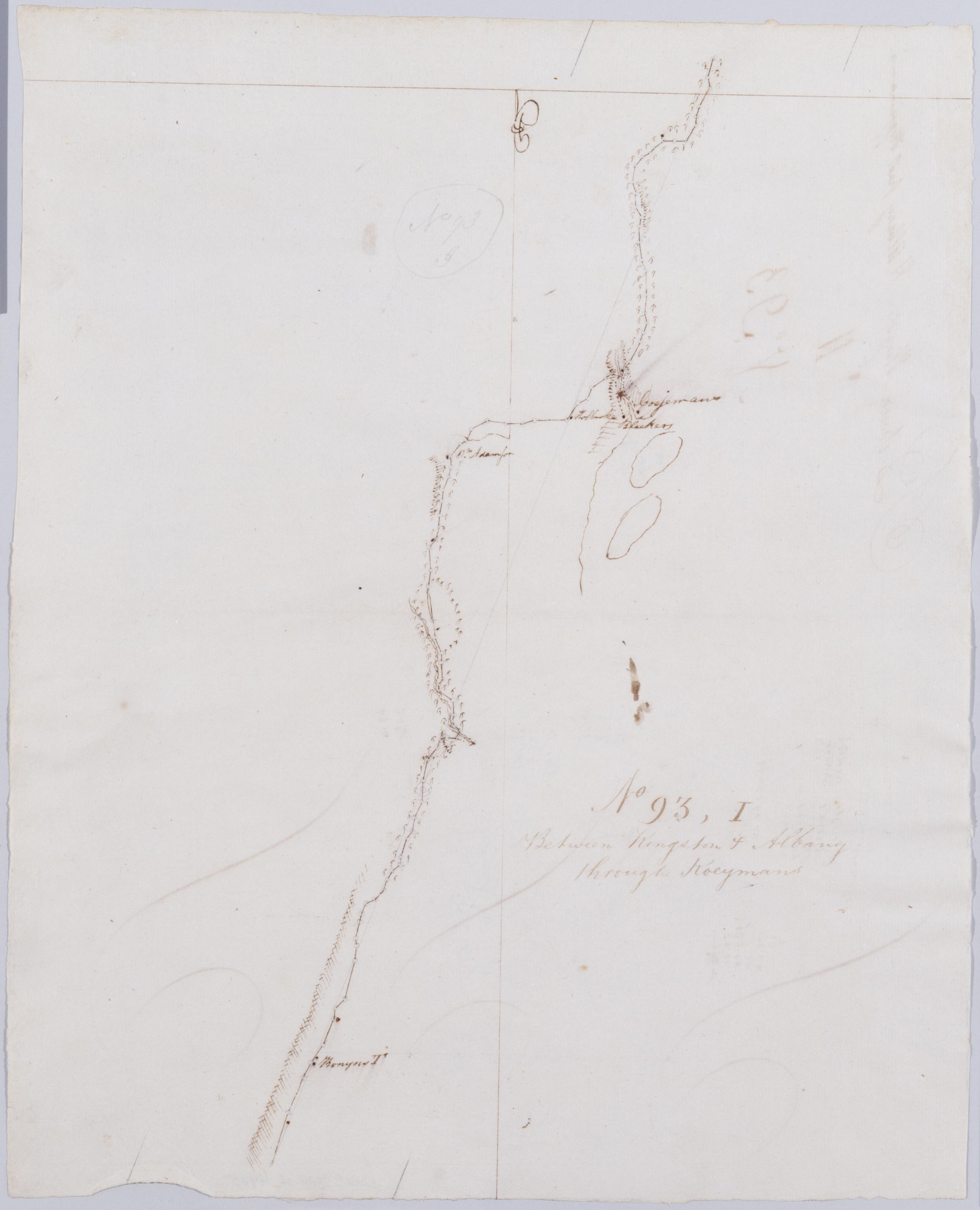
Cartographic Between Kingston + Albany thro' Koeymans. No 93, I / by Robert Erskine F.R.S. Geogr. A. U.S. and Assistants. Foxed, stained, creased and abraded. Mounted on cloth, bound and cropped, disbound and silked by subsequent owners. Cleaned after removal of backings 1999; some fill remains. Sheathed in mylar. In ink on verso: "I I I". In pencil on recto: "No 93 I". Military topographic map. Covers the townships of New Baltimore in Green County and of Coeyman in Albany County, New York. Shows roads running through Ravena and Coeyman. Also shows buildings and owners' names, landforms and streams. Pen-and-ink, pencil on laid paper. Shows relief by hachures. View Item
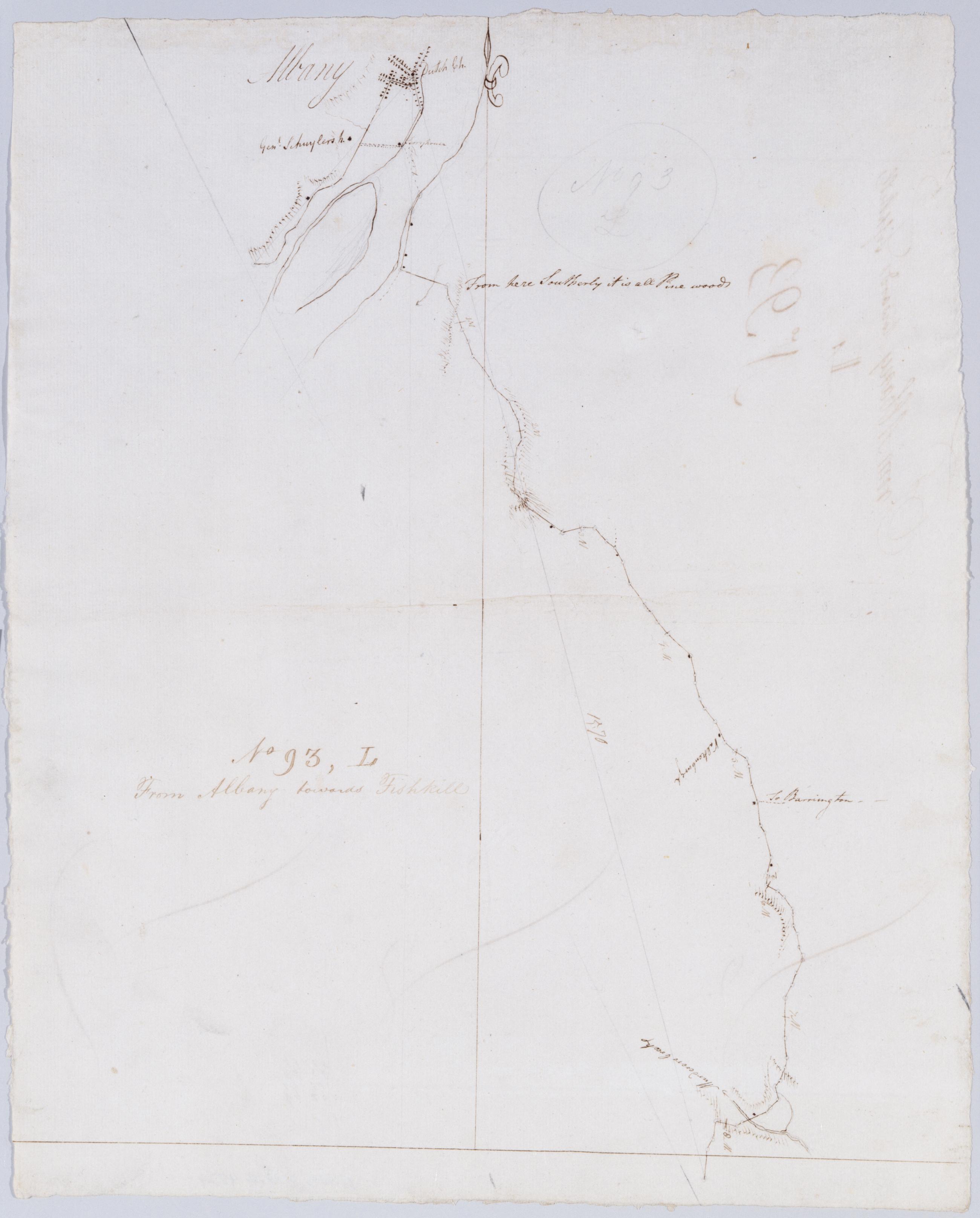
Cartographic From Albany towards Fishkill. No 93, L / by Robert Erskine F.R.S. Geogr. A. U.S. and Assistants. In ink on verso: "L L L". In pencil on recto: "No 93 L". Military topographic map. Covers the townships of Bethlehem in Albany County, East Greenbush and Schodack in Rensselaer County, New York. Shows roads running through Albany, East Greenbush and Schodack Center. Also shows buildings and owners names, landforms and streams. Pen-and-ink, pencil on laid paper. Shows relief by hachures. Stained, soiled, creased and abraded. Mounted on cloth, bound, disbound and silked by subsequent owners. Cleaned after removal of backings 1999; some fill remains. Sheathed in mylar. View Item
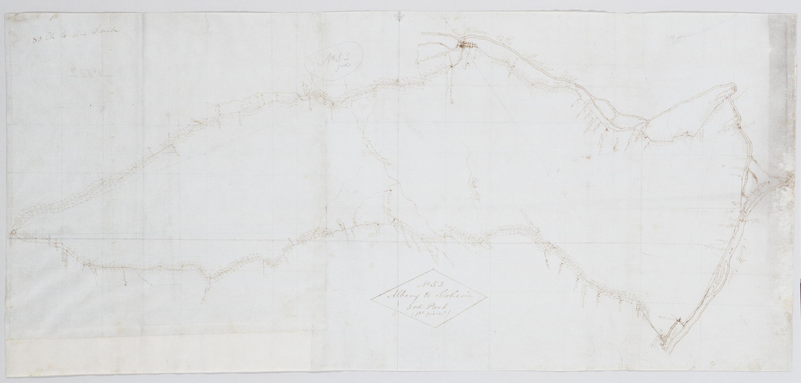
Cartographic Albany to Scoharie. No 52 3rd Part (1st piece) [sic]/ by Robert Erskine F.R.S. Geogr. A. U.S. and Assistants ; by Capt. Gray. Foxed, soiled, frayed, and abraded. Mounted on cloth, bound and cropped, disbound and silked by subsequent owners. Cleaned after removal of backings 1999; some fill remains. Sheathed in mylar. In pencil on recto and in ink on verso is written, incorrectly, "No. 52 3d" However, the handwriting is in neither case Erskine's. Index title, both statements of responsbility, date, series title and series numbering by Erskine, but on separate index sheet filed at head of series. Military topographic map. Covers the counties of Albany, Schenectady and Scoharie, New York. View Item
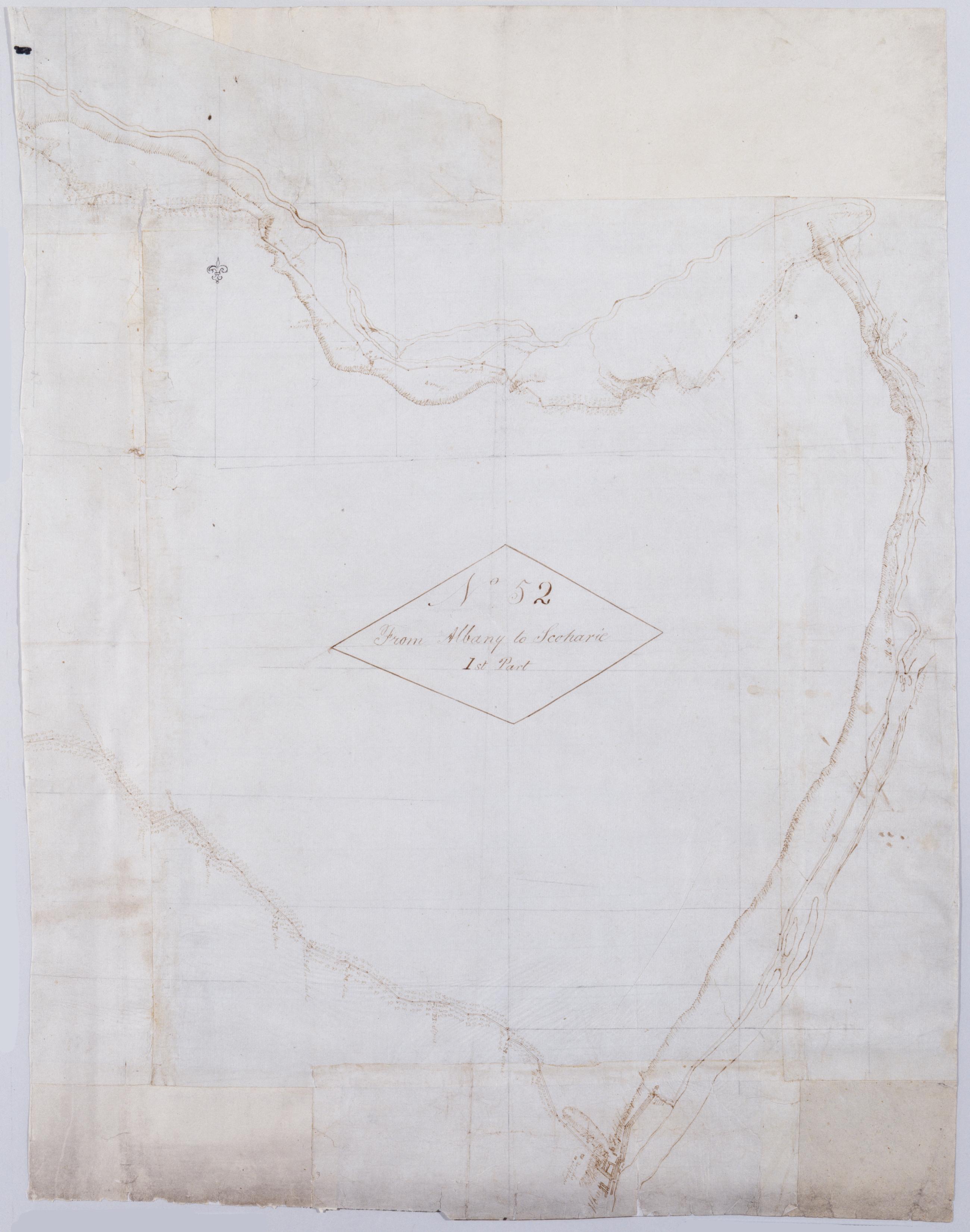
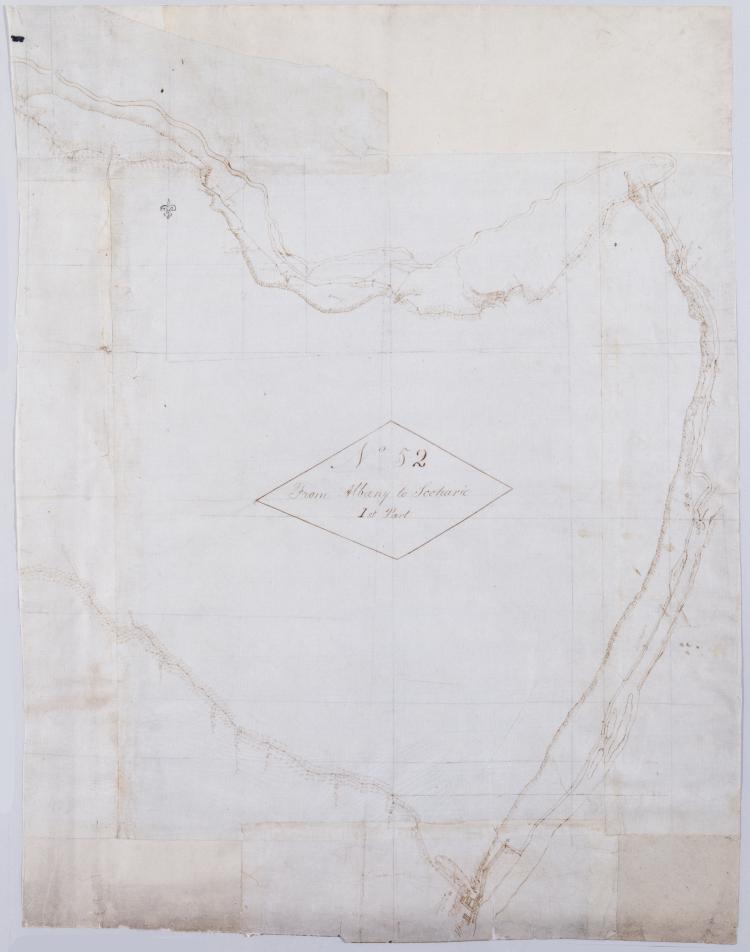
Cartographic From Albany to Scoharie. No 52 1st Part [sic] / by Robert Erskine F.R.S. Geogr. A. U.S. and Assistants ; by Capt. Gray, second sheet Military topographic map. Covers the counties of Albany, Schenectady and Scoharie, New York. Shows roads running through Albany, Westmere, Guilderland, Hartmans Corners, Guilderland Center, Altamont, Knox, Gallupville, Shutter Corners and, just north of Schoharie, Vrooman Corners; also Quaker Street, Duanesburg, Princeton or Kelley Station, Rotterdam, Schnectady, Hawthorne Hill, Niskayuna, Freligh, Crescent Station to near Crescent, Cohoes and Watervliet. Map also shows buildings and owners' names, landforms and streams. Shows relief by hachures. View Item
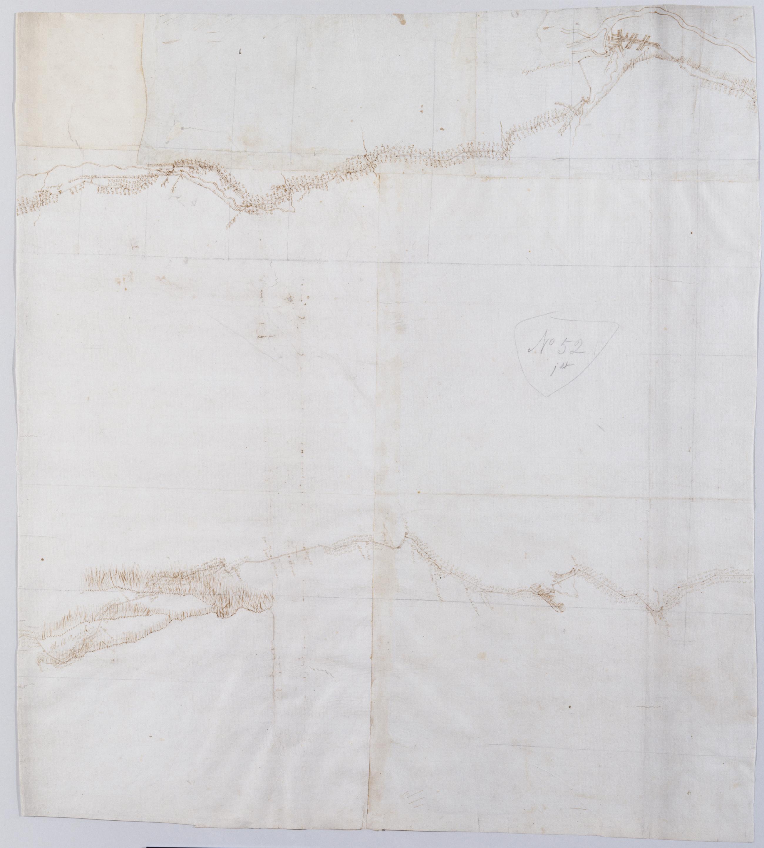
Cartographic From Albany to Scoharie. No 52 1st Part [sic] / by Robert Erskine F.R.S. Geogr. A. U.S. and Assistants ; by Capt. Gray, first sheet Military topographic map. Covers the counties of Albany, Schenectady and Scoharie, New York. Shows roads running through Albany, Westmere, Guilderland, Hartmans Corners, Guilderland Center, Altamont, Knox, Gallupville, Shutter Corners and, just north of Schoharie, Vrooman Corners; also Quaker Street, Duanesburg, Princeton or Kelley Station, Rotterdam, Schnectady, Hawthorne Hill, Niskayuna, Freligh, Crescent Station to near Crescent, Cohoes and Watervliet. Map also shows buildings and owners' names, landforms and streams. Shows relief by hachures. View Item
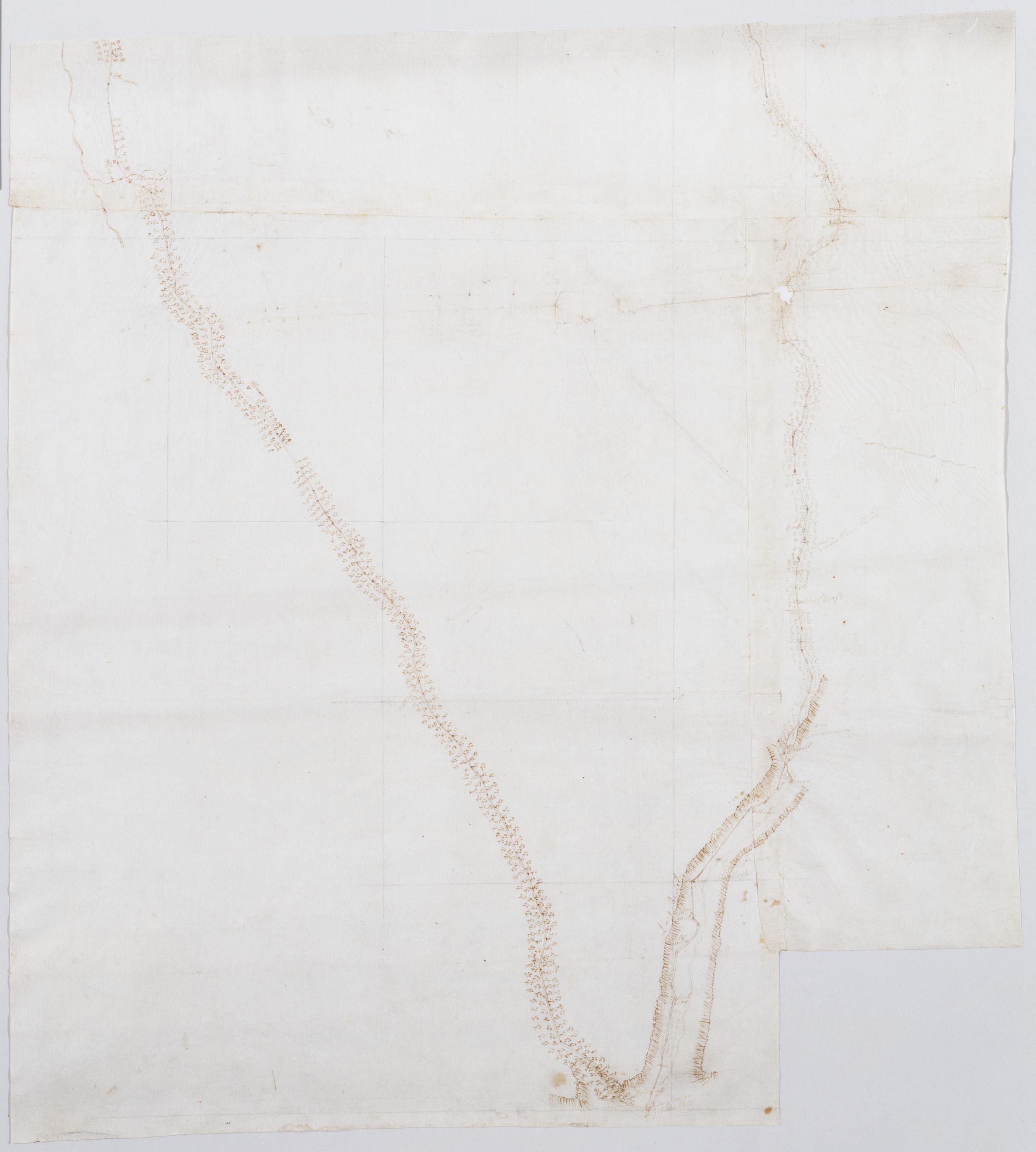
Cartographic From Albany to Scoharie. No 52 1st Part [sic] / by Robert Erskine F.R.S. Geogr. A. U.S. and Assistants ; by Capt. Gray, third sheet Military topographic map. Covers the counties of Albany, Schenectady and Scoharie, New York. Shows roads running through Albany, Westmere, Guilderland, Hartmans Corners, Guilderland Center, Altamont, Knox, Gallupville, Shutter Corners and, just north of Schoharie, Vrooman Corners; also Quaker Street, Duanesburg, Princeton or Kelley Station, Rotterdam, Schnectady, Hawthorne Hill, Niskayuna, Freligh, Crescent Station to near Crescent, Cohoes and Watervliet. Map also shows buildings and owners' names, landforms and streams. Shows relief by hachures. View Item
Image Cartographic 3 Items From Albany to Scoharie. No 52 1st Part [sic] / by Robert Erskine F.R.S. Geogr. A. U.S. and Assistants ; by Capt. Gray. Military topographic map. Covers the counties of Albany, Schenectady and Scoharie, New York. Shows roads running through Albany, Westmere, Guilderland, Hartmans Corners, Guilderland Center, Altamont, Knox, Gallupville, Shutter Corners and, just north of Schoharie, Vrooman Corners; also Quaker Street, Duanesburg, Princeton or Kelley Station, Rotterdam, Schnectady, Hawthorne Hill, Niskayuna, Freligh, Crescent Station to near Crescent, Cohoes and Watervliet. Map also shows buildings and owners' names, landforms and streams. Shows relief by hachures. View Item
Cartographic Between Kingston + Albany past Van Wie's. No 93 K / by Robert Erskine F.R.S. Geogr. A. U.S. and Assistants. Foxed- stained- soiled- creased and abraded. Mounted on cloth- bound and cropped- disbound and silked by subsequent owners. Cleaned after removal of backings 1999; some fill remains. Sheathed in mylar. In ink on verso: "K K K". In pencil on recto: "No 93 K". Military topographic map. Covers the townships of Coeyman and Bethlehem in Albany County- New York. Shows roads running through Cedar Hill and Glenmont. Also shows buildings and owners' names- landforms and streams. Pen-and-ink- pencil on laid paper. Shows relief by hachures. View Item
Cartographic Between Kingston + Albany thro' Koeymans. No 93 I / by Robert Erskine F.R.S. Geogr. A. U.S. and Assistants. Foxed- stained- creased and abraded. Mounted on cloth- bound and cropped- disbound and silked by subsequent owners. Cleaned after removal of backings 1999; some fill remains. Sheathed in mylar. In ink on verso: "I I I". In pencil on recto: "No 93 I". Military topographic map. Covers the townships of New Baltimore in Green County and of Coeyman in Albany County- New York. Shows roads running through Ravena and Coeyman. Also shows buildings and owners' names- landforms and streams. Pen-and-ink- pencil on laid paper. Shows relief by hachures. View Item
Cartographic From Albany towards Fishkill. No 93 L / by Robert Erskine F.R.S. Geogr. A. U.S. and Assistants. In ink on verso: "L L L". In pencil on recto: "No 93 L". Military topographic map. Covers the townships of Bethlehem in Albany County- East Greenbush and Schodack in Rensselaer County- New York. Shows roads running through Albany- East Greenbush and Schodack Center. Also shows buildings and owners names- landforms and streams. Pen-and-ink- pencil on laid paper. Shows relief by hachures. Stained- soiled- creased and abraded. Mounted on cloth- bound- disbound and silked by subsequent owners. Cleaned after removal of backings 1999; some fill remains. Sheathed in mylar. View Item
Cartographic Albany to Scoharie. No 52 3rd Part (1st piece) [sic]/ by Robert Erskine F.R.S. Geogr. A. U.S. and Assistants ; by Capt. Gray. Foxed- soiled- frayed- and abraded. Mounted on cloth- bound and cropped- disbound and silked by subsequent owners. Cleaned after removal of backings 1999; some fill remains. Sheathed in mylar. In pencil on recto and in ink on verso is written- incorrectly- "No. 52 3d" However- the handwriting is in neither case Erskine's. Index title- both statements of responsbility- date- series title and series numbering by Erskine- but on separate index sheet filed at head of series. Military topographic map. Covers the counties of Albany- Schenectady and Scoharie- New York. View Item
Cartographic From Albany to Scoharie. No 52 1st Part [sic] / by Robert Erskine F.R.S. Geogr. A. U.S. and Assistants ; by Capt. Gray. Military topographic map. Covers the counties of Albany- Schenectady and Scoharie- New York. Shows roads running through Albany- Westmere- Guilderland- Hartmans Corners- Guilderland Center- Altamont- Knox- Gallupville- Shutter Corners and- just north of Schoharie- Vrooman Corners; also Quaker Street- Duanesburg- Princeton or Kelley Station- Rotterdam- Schnectady- Hawthorne Hill- Niskayuna- Freligh- Crescent Station to near Crescent- Cohoes and Watervliet. Map also shows buildings and owners' names- landforms and streams. Shows relief by hachures. View Item