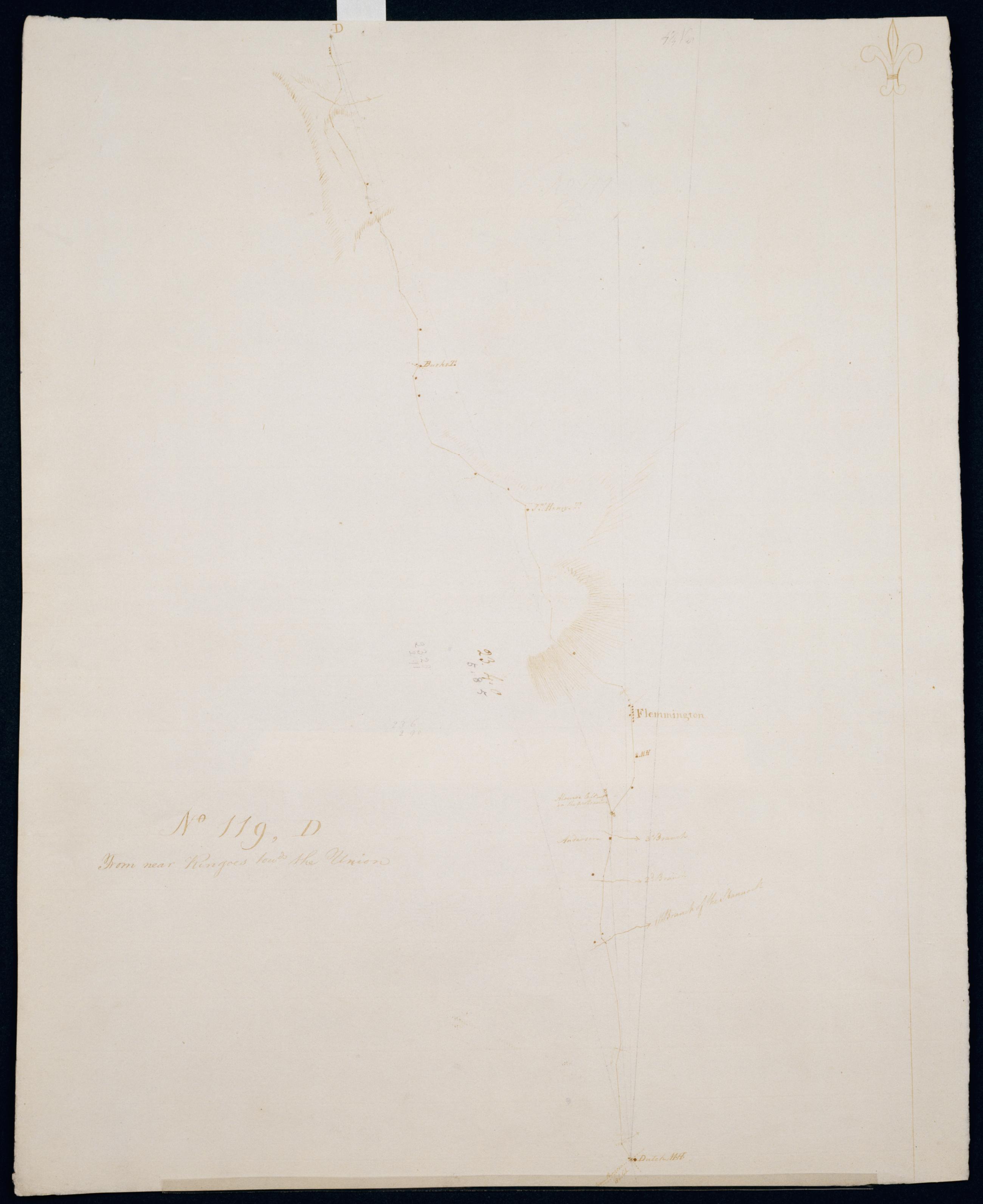
Cartographic From near Ringoes towds the Union. No 119, D / S DeWitt Geographer to the Army of the United States ; by Robert Erskine F.R.S. Geogr. A. U.S. and Assistants. Date of 1780 or 1781 based on verso text to sheet 119,F of series. First statement of responsibility from verso text on sheet 119,F of series. Military topographic map. Covers the townships of Raritan and Franklin in Hunterdon County, New Jersey. Shows roads running through Clinton, Sidney, Cherryville, Klinesville, Flemington, Copper Hill, Muirhead and Larison Corner. Also shows buildings and owners' names, landforms and streams. Pen-and-ink, pencil on laid paper. Shows relief by hachures. Stained, soiled , creased and abraded. View Item
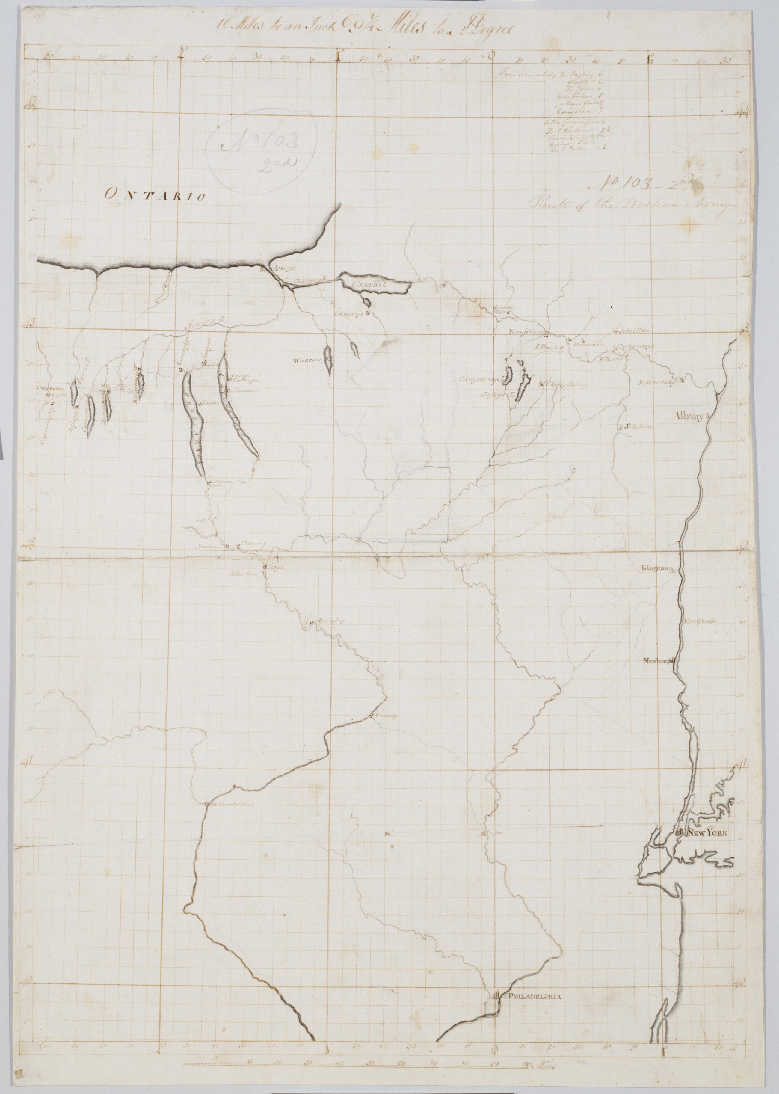
Cartographic Route of the Western Army. No 103-2nd [i.e., No. 101-4th] by R.E. ; by Robert Erskine F.R.S. Geogr. A. U.S. and Assistants. In pencil on recto: "No 103 2nd" and on verso "No: 103." Military topographical map. Covers parts of New York, Pennsylvania and New Jersey. Pen-and-ink, pencil on laid paper. Sheet carries no title on verso. Shows relief by hachures. Soiled, stained, creased and abraded. Mounted on cloth, bound and cropped, disbound and silked by subsequent owners. Cleaned after removal of backings 1999; some fill remains. Sheathed in mylar. Title proper from recto is the work of a later editor--Simeon DeWitt or his assign--subsequent to 1820. View Item
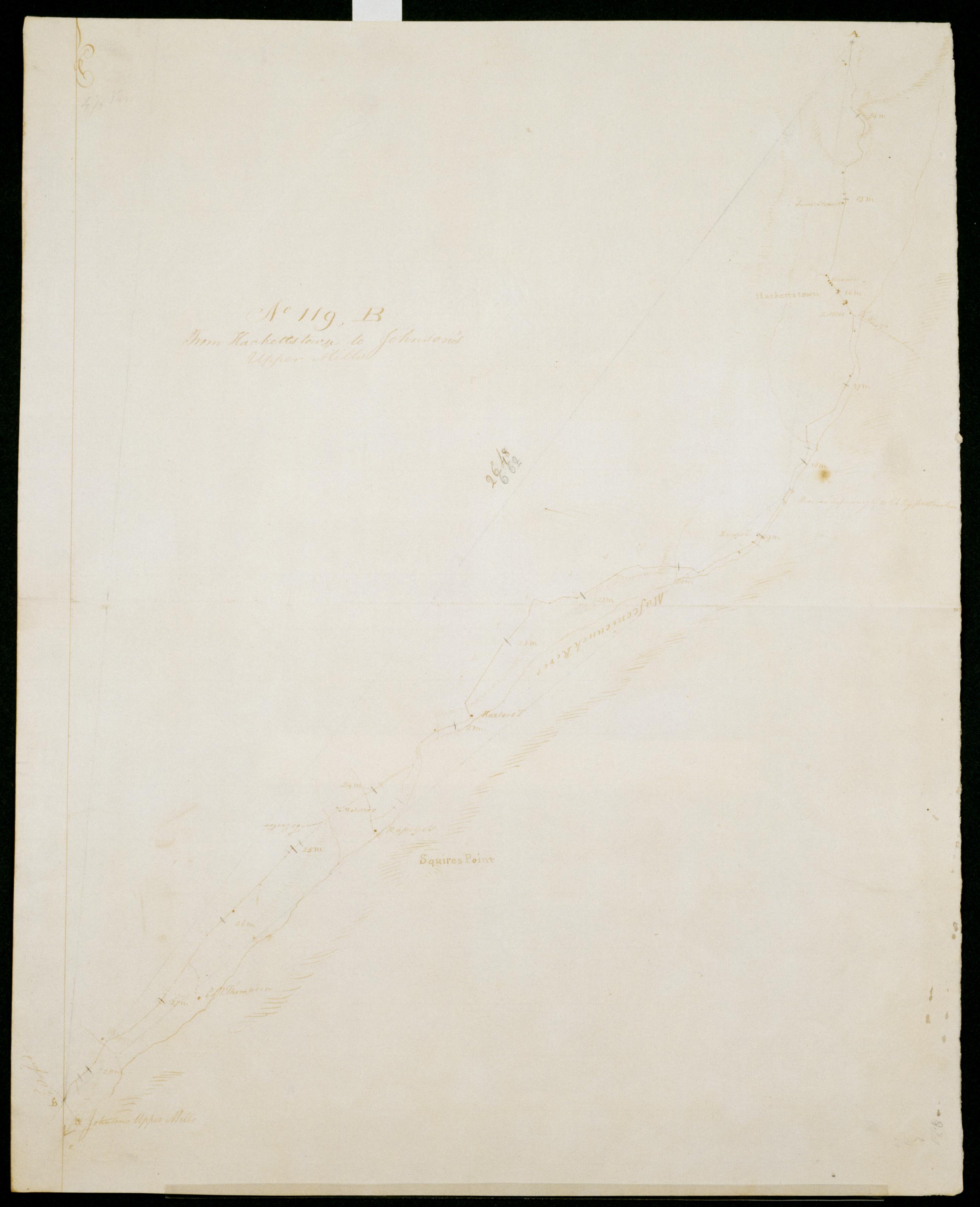
Cartographic From Hackettstown to Johnson's Upper Mills. No 119, B / S DeWitt Geographer to the Army of the United States ; by Robert Erskine F.R.S. Geogr. A. U.S. and Assistants. Date of 1780 or 1781 based on verso text to sheet 119,F of series. First statement of responsibility from verso text on sheet 119,F of series. In erased pencil on recto: "No 119 ..." Military topographic map. Covers the townships of Allamuchy, Independence, Mansfield and Washington in Warren County, New Jersey. Shows roads running through Hackettstown, Beatyestown, Penwell and Anderson. Also shows buildings and owners' names, landforms and streams. Pen-and-ink, pencil on laid paper. Shows relief by hachures. Stained, soiled , creased and abraded. View Item
Cartographic Road from near the 14 M. S. from Burlington thro' Moorstown & Mount Holly to one James Sippingwill's. No 87, F / by Robert Erskine F.R.S. Geogr. A. U.S. and Assistants. In ink on verso: "No. 87 F." In pencil on recto: "No 87 F". Military topographic map. Covers the townships of Northampton, Lumberton, Mount Laurel, Chester and Cinnaminson in Burlington County and of Pensauken in Camden County, New Jersey. Shows roads running through Morrisville, Parry, New Albany, Union Mills, Hainesport and Mount Holly. Also shows buildings and owners' names, landforms and streams. Pen-and-ink, pencil on laid paper. Shows relief by hachures. Soiled, foxed, creased, frayed and abraded. Mounted on cloth, cropped, bound, disbound and silked by subsequent owners. View Item
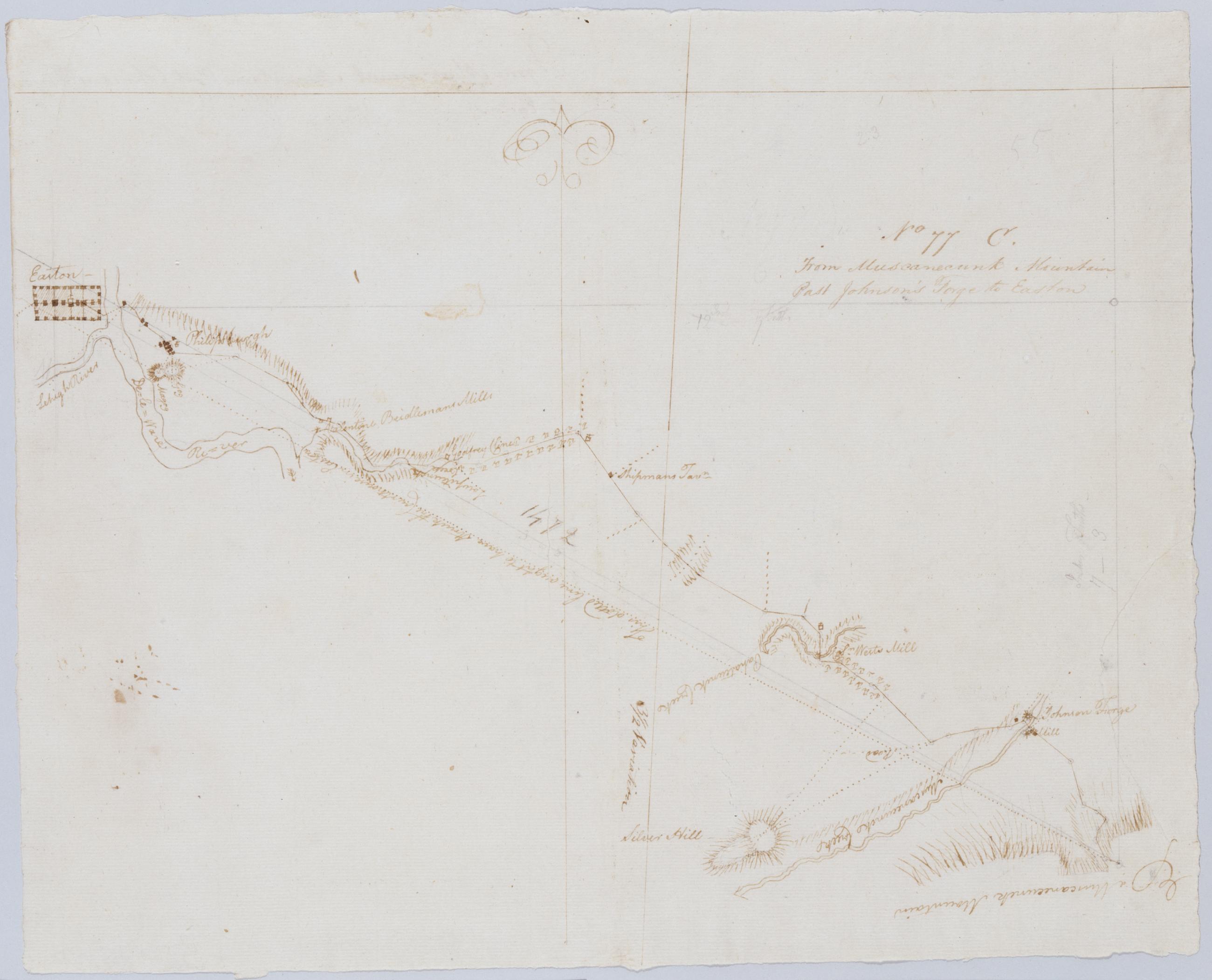
Cartographic From Muscanecunk Mountain Past Johnson's Forge to Easton. No 77 C / by Robert Erskine F.R.S. Geogr. A. U.S. and Assistants. In erased pencil on recto: "No 77 C". Military topographic map. Covers the townships of Greenwich and Pohatcong in Warren County and of Bethlehem in Hunterdon County, New Jersey; also covers part of Berks County, Pennsylvania. Shows roads running through Bloomsbury, Kennedy Mills, Still Valley and Phillipsburg in New Jersey as well as Easton, Pennsylvania. Also shows buildings and owners' names, landforms and streams. Pen-and-ink, pencil on laid paper. Shows relief by hachures. Title proper from recto is the work of a later editor--Simeon DeWitt or his assign--subsequent to 1820. View Item
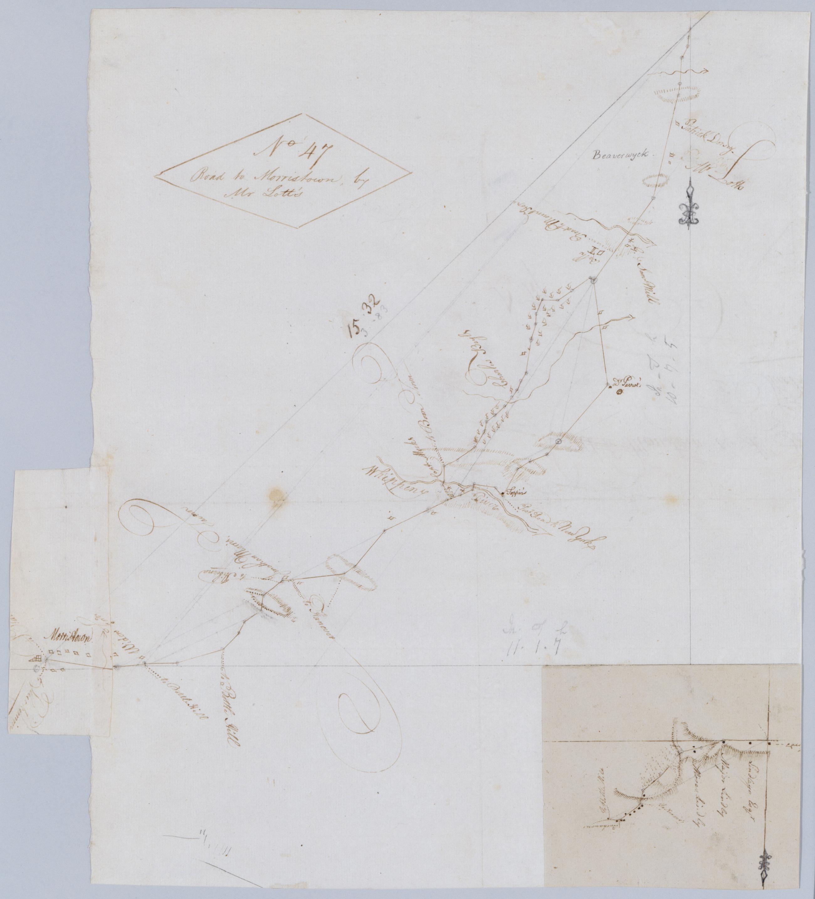
Cartographic Road to Morristown, by Mr Lott's. No 47 / by Robert Erskine F.R.S. Geogr. A. U.S. and Assistants. Foxed, creased, frayed, and abraded. Mounted on cloth, bound and cropped, disbound and silked by subsequent owners. Cleaned after removal of backings 1999; some fill remains. Sheathed in mylar. In ink on verso: William. Includes an untitled inset map pasted upside down at lower right of main sheet. This inset shows the road between Morristown and Monroe in greater detail. Military topographic map. Covers the township of Hanover in Morris County, New Jersey. Shows roads running through Morristown, Monroe, Whippany and Troy Hills. Also shows buildings and owners' names, landforms and streams. View Item
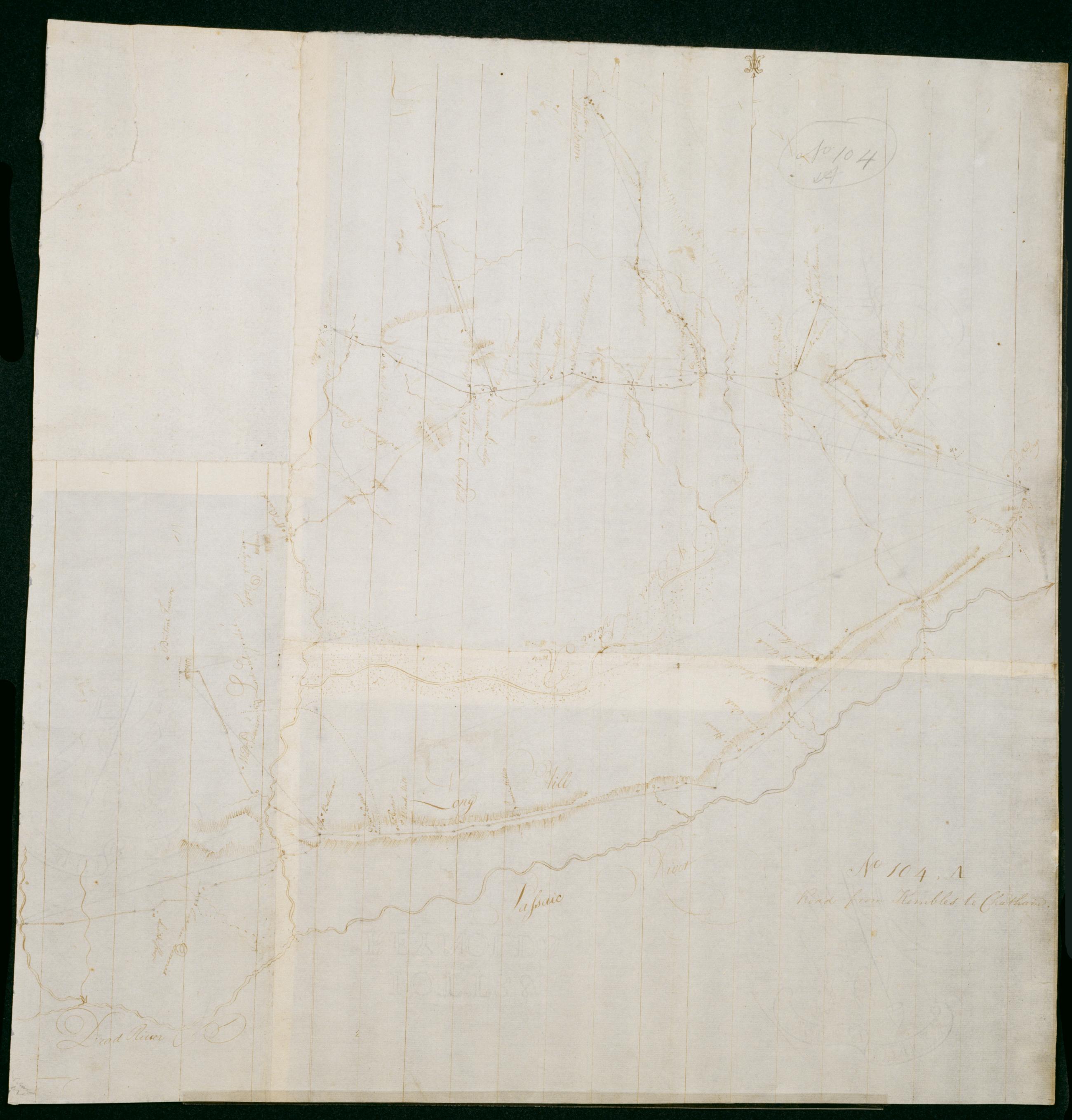
Cartographic Road from Kembles to Chatham. No 104, A / by Robert Erskine F.R.S. Geogr. A. U.S. and Assistants. Foxed, creased, frayed and abraded. Mounted on cloth, bound and cropped, disbound and silked by subsequent owners. Cleaned after removal of backings 1999; some fill remains. Sheathed in mylar. In pencil on recto: "No 104 A". Military topographic map. Covers the townships of Passaic and Morris in Morris County and of Bernard in Somerset County, New Jersey. Shows roads running through Chatham, Morristown, Logansville, Millington and Liberty Corner. Also shows buildings and owners' names, landforms and streams. Pen-and-ink, pencil on laid paper. Shows relief by hachures. View Item
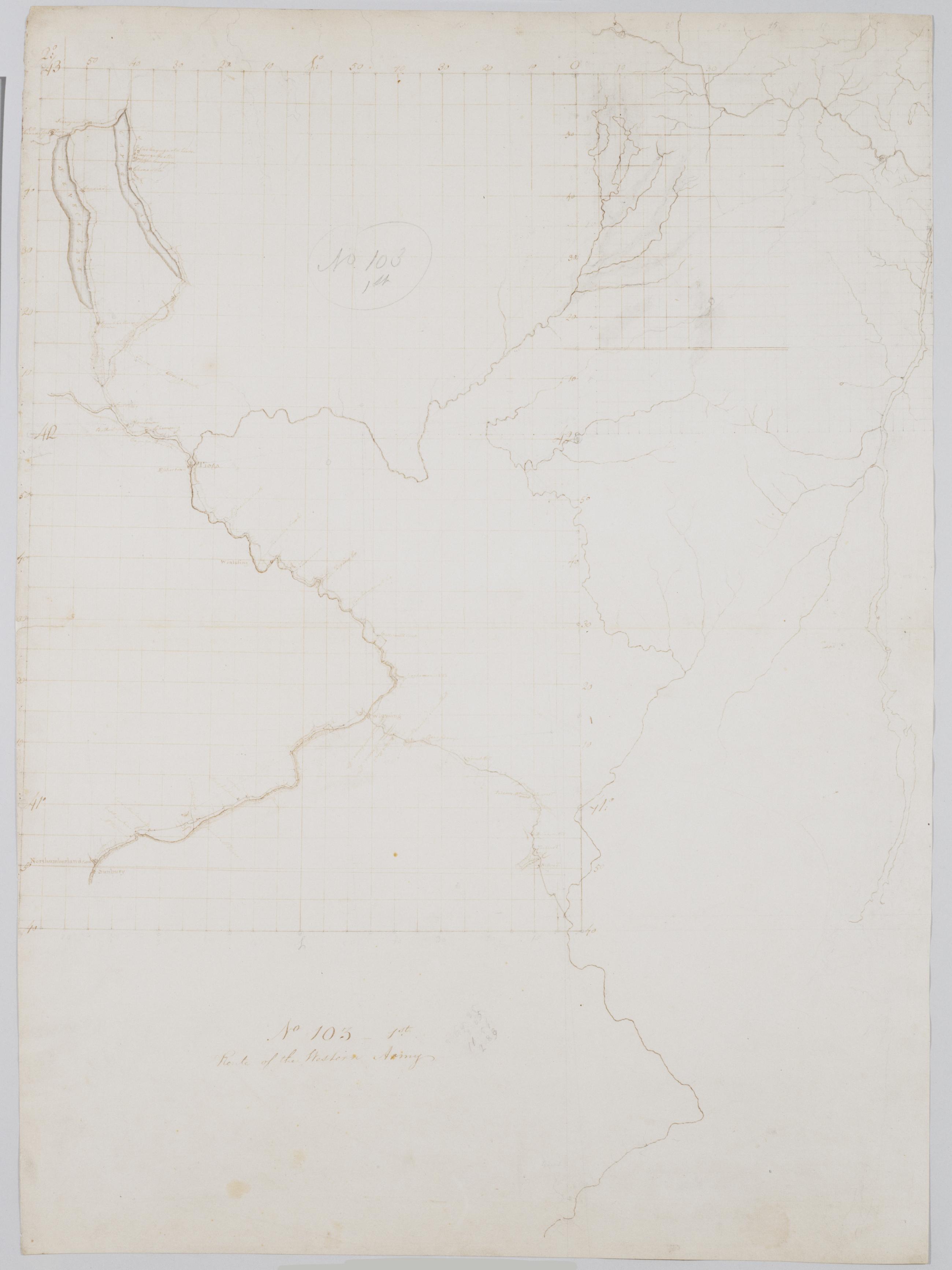
Cartographic Route of the Western Army. No 103-1st [i.e., No. 101-3rd] by R.E. ; by Robert Erskine F.R.S. Geogr. A. U.S. and Assistants. In pencil on recto: "No 103 1st" and on verso "No 103." Military topographical map. Covers parts of New York, Pennsylvania and New Jersey. Pen-and-ink, pencil on laid paper. Sheet carries no title on verso. Shows relief by hachures. Soiled, stained, creased and abraded. Mounted on cloth, bound and cropped, disbound and silked by subsequent owners. Cleaned after removal of backings 1999; some fill remains. Sheathed in mylar. Title proper from recto is the work of a later editor--Simeon DeWitt or his assign--subsequent to 1820. View Item
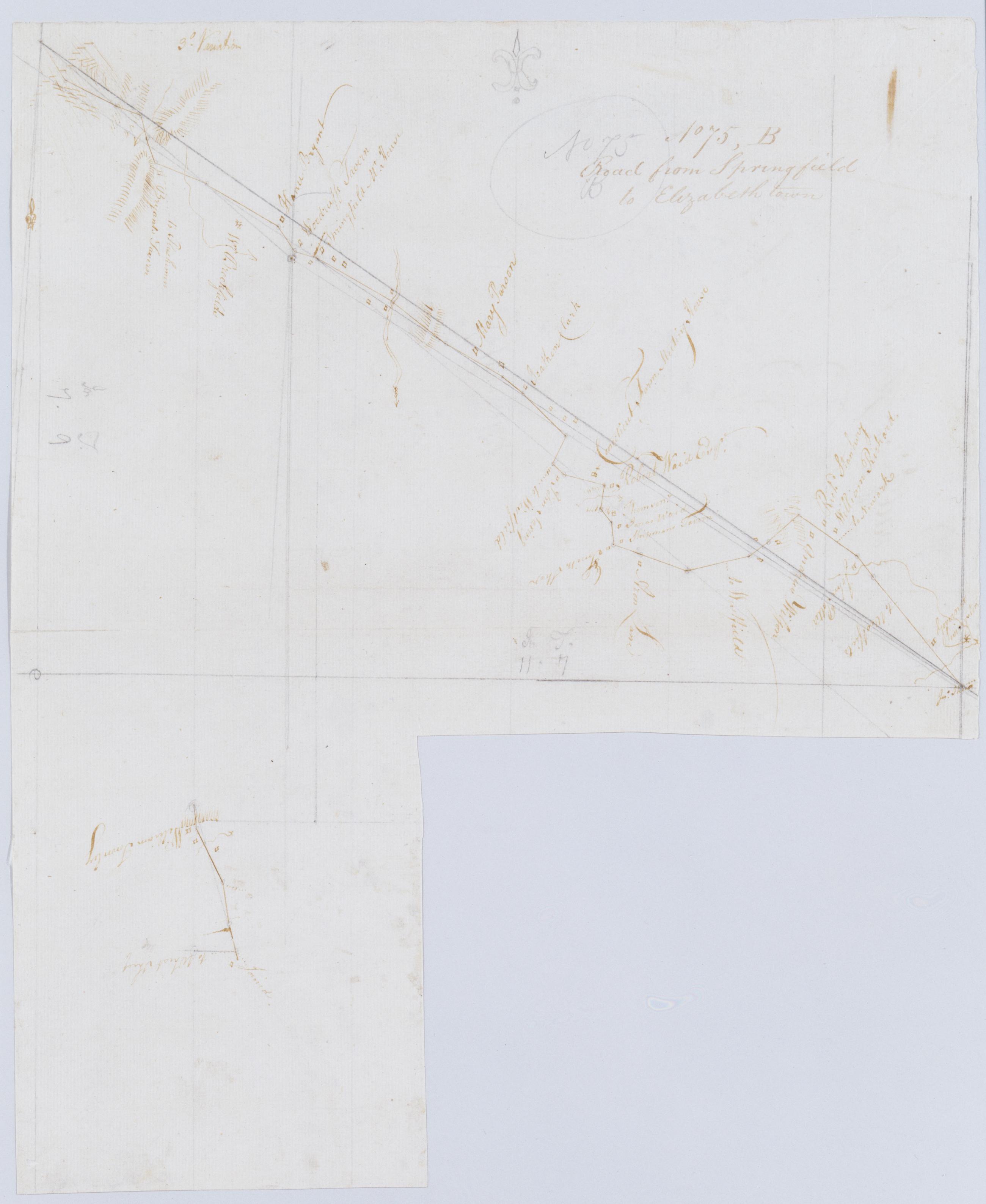
Cartographic Road from Springfield to Elizabeth town. No 75, B / by Robert Erskine F.R.S. Geogr. A. U.S. and Assistants. Imperfect: 15 x 19 cm. at lower right corner cut out after drawing complete; compare cuts to those on 75,A. In pencil on recto: "No 75 B". Military topographic map; lower segment fits to the southeast of the upper one. Map covers the townships of Summit, Springfield and Union in Union County, New Jersey. Shows roads running through Springfield and Elizabeth. Also shows buildings and owners' names, landforms and streams. Pen-and-ink, pencil on laid paper. Shows relief by hachures. Stained, creased and abraded. Mounted on cloth, bound and cropped, disbound and silked by subsequent owners. View Item
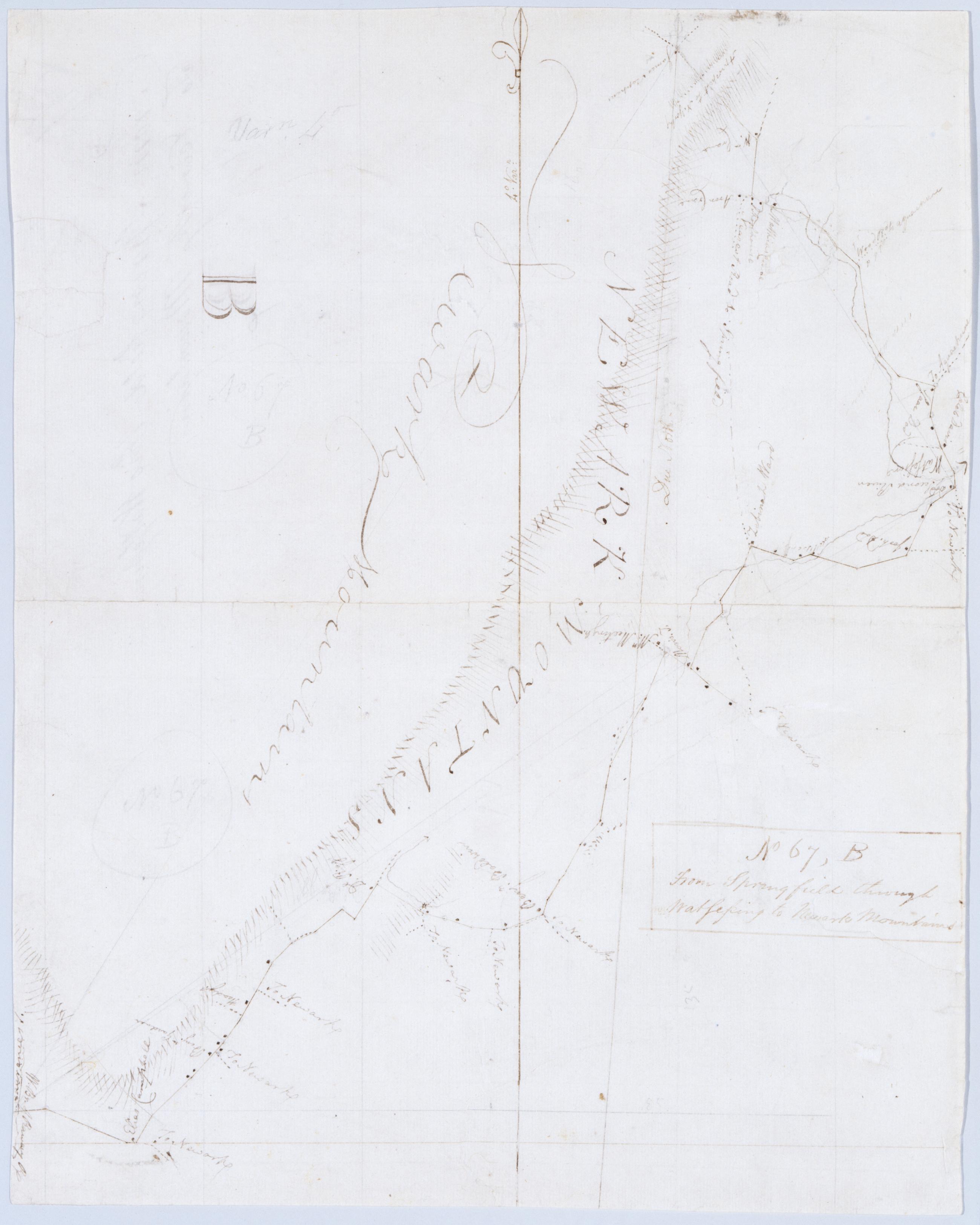
Cartographic From Springfield through Watsessing to Newark Mountains. No 67, B / by Robert Erskine F.R.S. Geogr. A. U.S. and Assistants. In ink on recto: "B". In pencil on recto: "No 67 B". Military topographic map. Covers the townships of Montclair, Plainfield, West Orange, South Orange and Milburn in Essex County, New Jersey. Shows roads running through Brookdale, Franklin, Bloomfield, Watsessing, South Orange and Wyoming. Also shows buildings and owners' names, also landforms and streams. Pen-and-ink, pencil on laid paper. Shows relief by hachures. Stained, foxed, creased, frayed and abraded. Mounted on cloth, bound and cropped, disbound and silked by subsequent owners. View Item
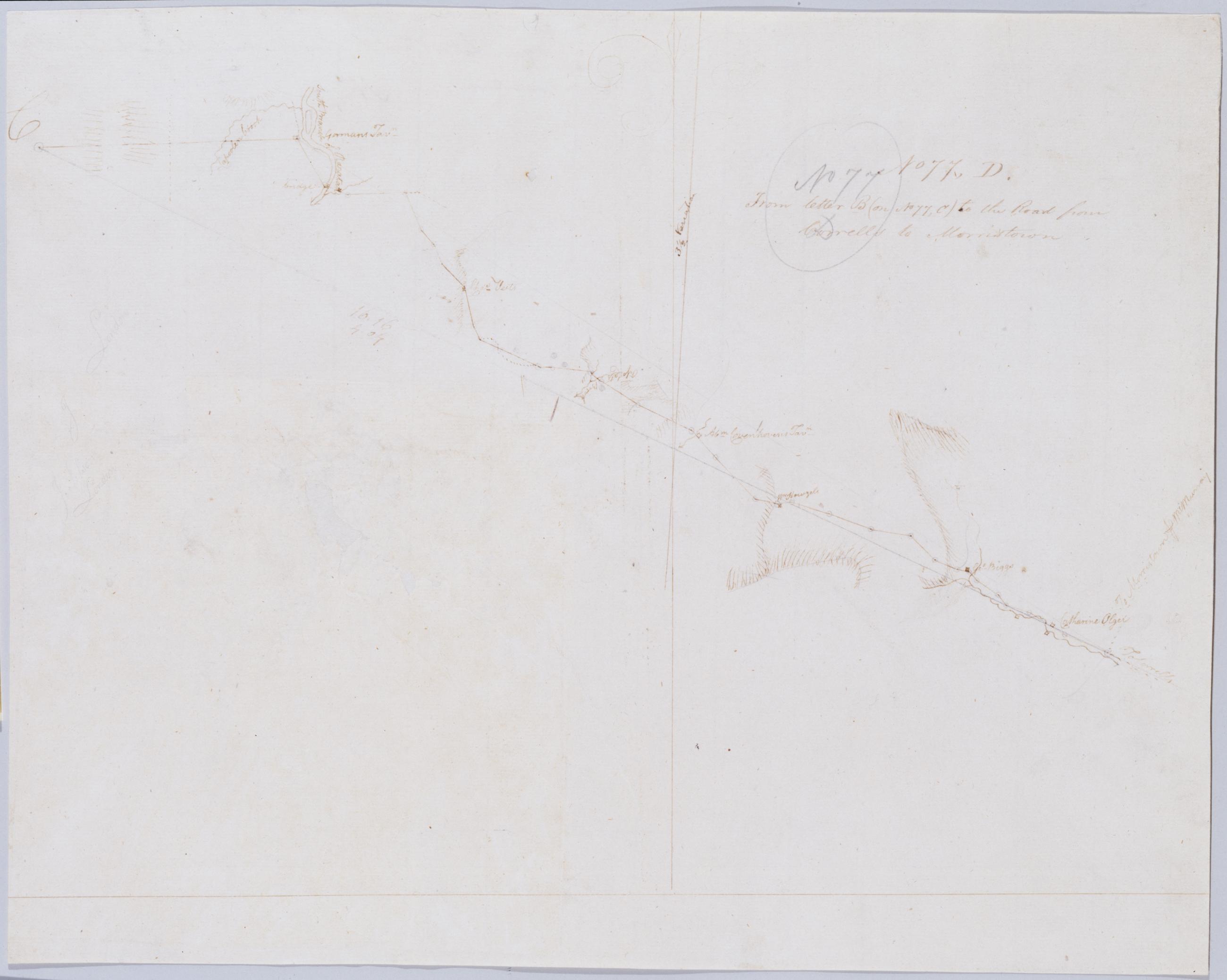
Cartographic From letter B (on No 77, C) to the Road from Corrells to Morristown. No 77, D / by Robert Erskine F.R.S. Geogr. A. U.S. and Assistants. In erased pencil on recto: "No 77 C". Military topographic map. Covers the townships of Franklin and Readington in Hunterdon County, New Jersey. Shows roads running through Lansdowne, Hamden, Sunnyside, Stanton and Pleasant Run. Also shows buildings and owners' names, landforms and streams. Notice that the verso title's "Letter B of the same number" properly refers to sheet 77,B not to any mark on sheet 77,C. Pen-and-ink, pencil on laid paper. Shows relief by hachures. Title proper from recto is the work of a later editor--Simeon DeWitt or his assign--subsequent to 1820. View Item
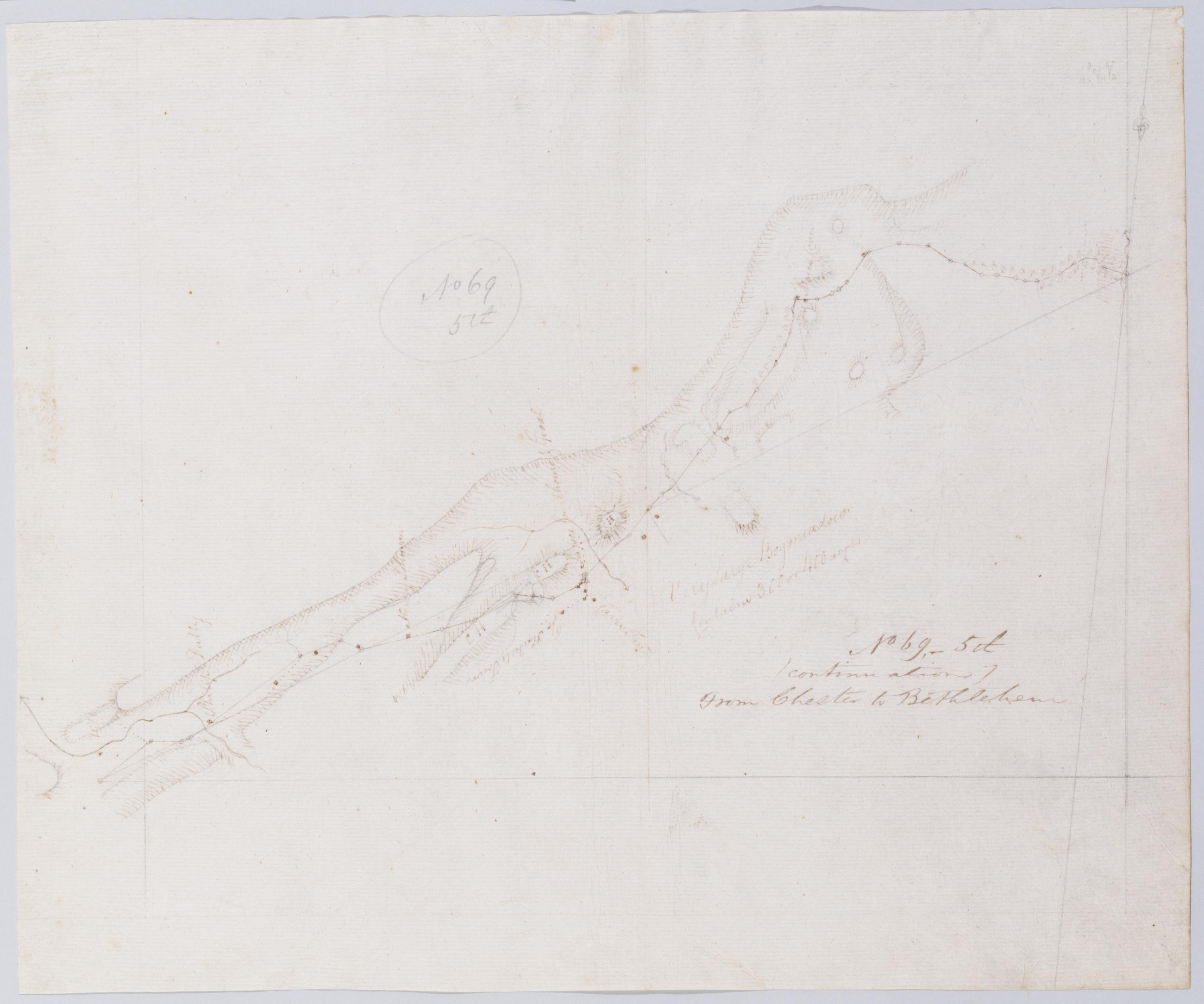
Cartographic (Continuation) From Chester to Bethlehem. No 69-5th / by Robert Erskine F.R.S. Geogr. A. U.S. and Assistants. In pencil on recto: "No 69 5th". Military topographic map. Covers the townships of Lafayette and Hampton in Sussex County, New Jersey. Shows roads running through Newton. Also shows buildings and owners' names, landforms and streams. Pen-and-ink, pencil on laid paper. Shows relief by hachures. Stained, foxed, creased and abraded. Mounted on cloth, bound and cropped, disbound and silked by subsequent owners. Cleaned after removal of backings 1999; some fill remains. Sheathed in mylar. Title proper on recto is the work of a later editor--Simeon DeWitt or his assign--subsequent to 1820. View Item
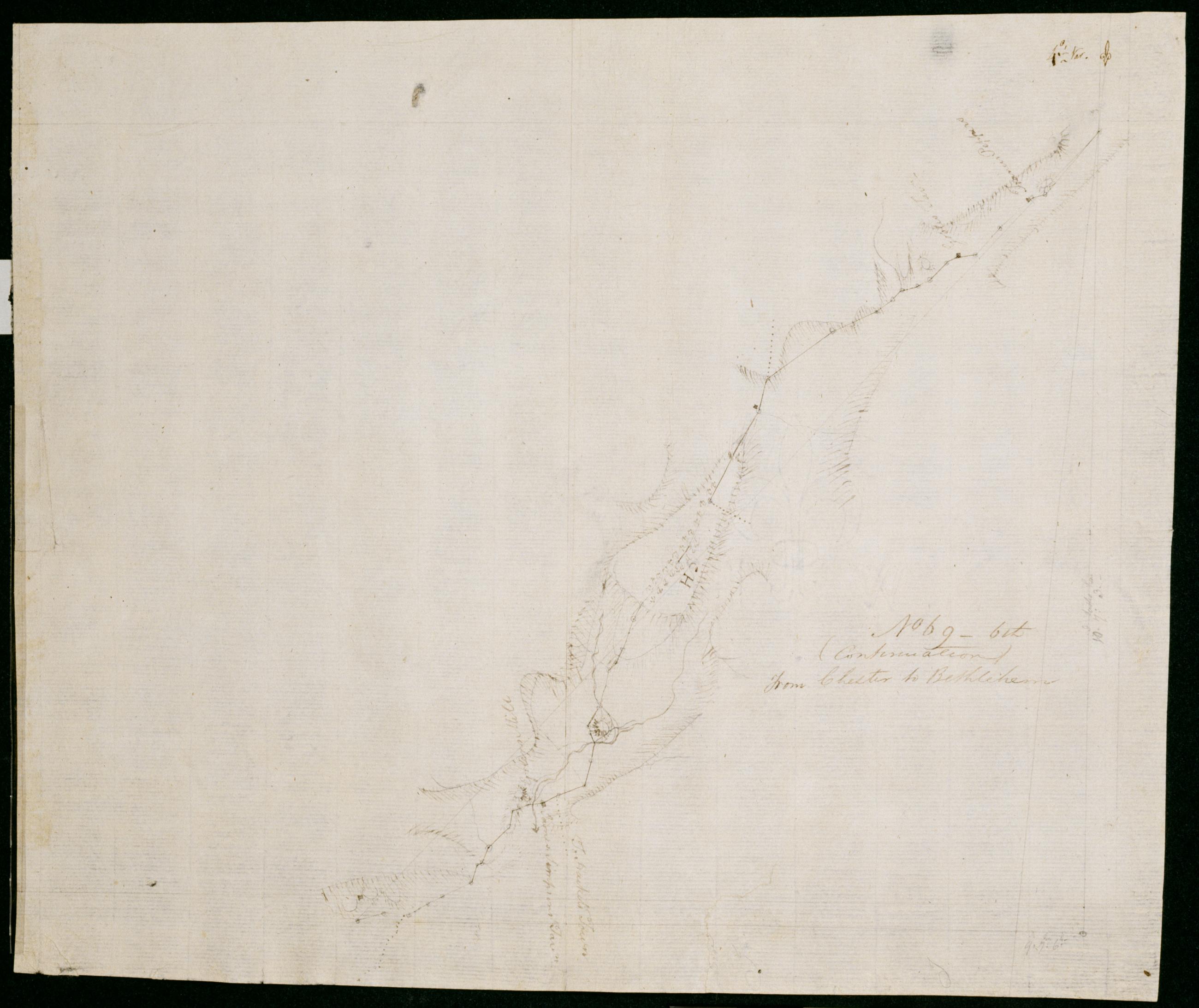
Cartographic (Continuation) From Chester to Bethlehem. No 69-6th / by Robert Erskine F.R.S. Geogr. A. U.S. and Assistants. In ink on verso: "No. 69 6th. Sheet SD SD SD SD SD SD". In pencil on recto: "No 69 6th". Military topographic map. Covers the township of Frelinghuysen in Warren County, New Jersey. Also shows buildings and owners' names, landforms and streams. Pen-and-ink, pencil on laid paper. Shows relief by hachures. Stained, creased and abraded. Mounted on cloth, bound and cropped, disbound and silked by subsequent owners. Cleaned after removal of backings 1999; some fill remains. Sheathed in mylar. Title proper on recto is the work of a later editor--Simeon DeWitt or his assign--subsequent to 1820. View Item
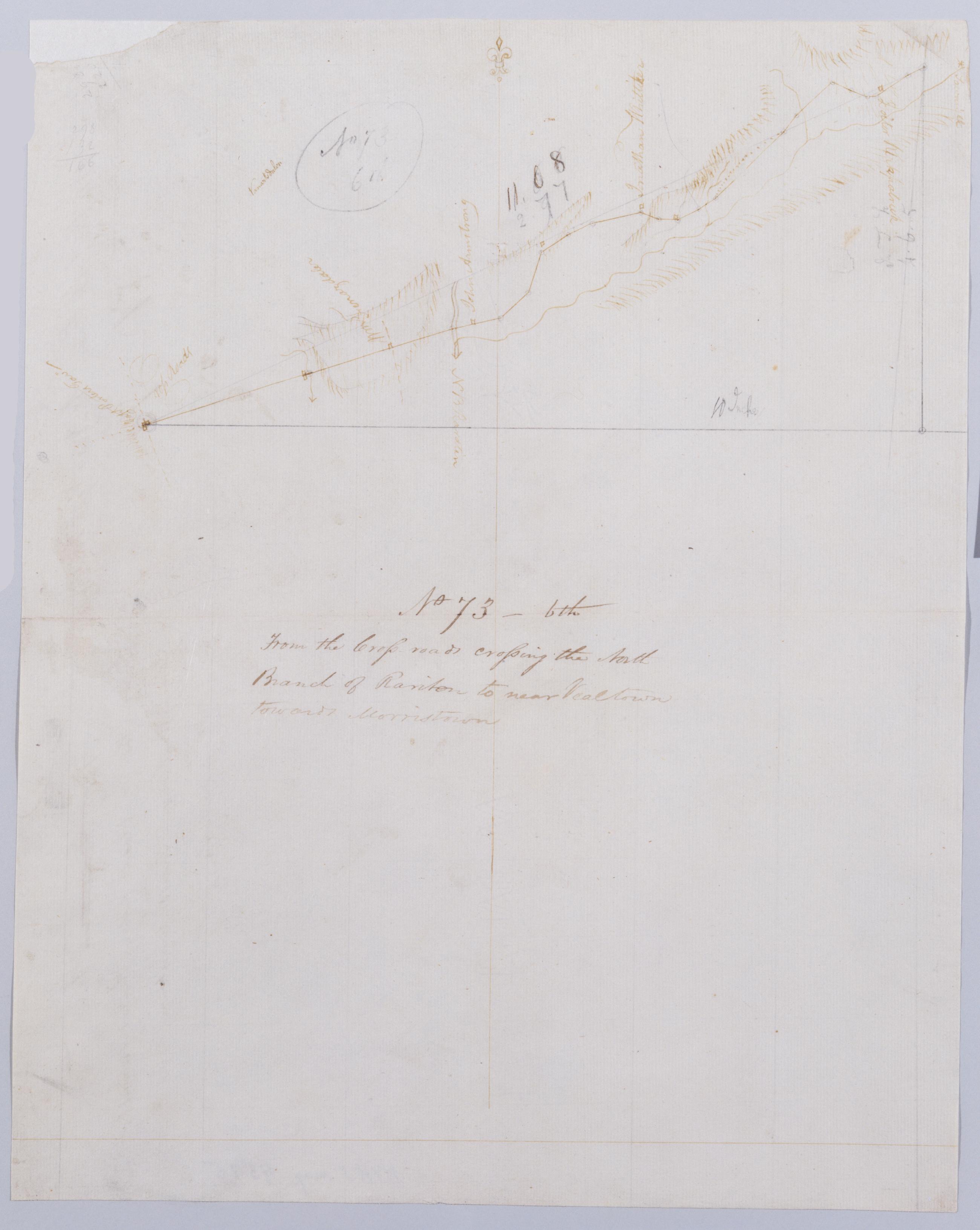
Cartographic From the Cross-roads crossing the North Branch of Rariton to near Vealtown towards Morristown. No 73, 6th / by Robert Erskine F.R.S. Geogr. A. U.S. and Assistants. Also in ink on verso: "Road from near Veal". Foxed, creased, torn, frayed and abraded. Mounted on cloth, bound and cropped, disbound and silked by subsequent owners. Cleaned after removal of backings 1999; some fill remains. Sheathed in mylar. In pencil on recto: "No 73 6th". Military topographic map. Covers the townships of Bedminster and Bernard in Somerset County, New Jersey. Shows roads running through Greater Crossroads, Bedminster and Far Hills. Also shows buildings and owners' names, landforms and streams. Pen-and-ink, pencil on laid paper. Shows relief by hachures. View Item
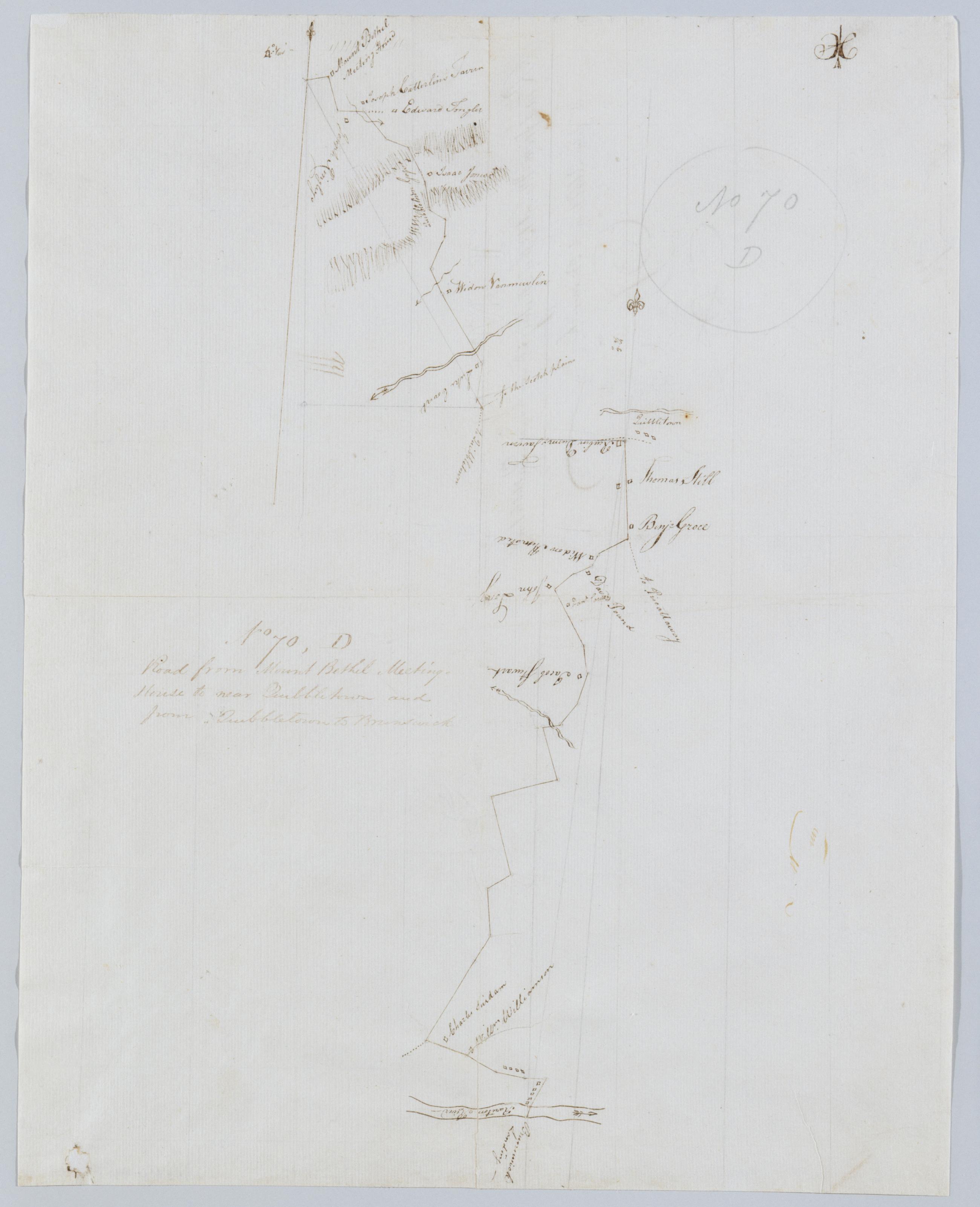
Cartographic Road from Mount Bethel Meeting House to near Quibbletown and from Quibbletown to Brunswick. No 70, D / by Robert Erskine F.R.S. Geogr. A. U.S. and Assistants. Foxed, creased and abraded. Mounted on cloth, bound and cropped, disbound and silked by subsequent owners. Cleaned after removal of backings 1999; some fill remains. Sheathed in mylar. Imperfect: lacking small piece at lower left corner. In pencil on recto: "No 70 D". Military topographic map. Covers the townships of Warren and North Plainfield in Somerset County and of Piscataway in Middlesex County, New Jersey. Shows roads running through Mt. Bethel, Newmarket, Newtown and New Brunswick. Also shows buildings and owners' names, landforms and streams. Pen-and-ink, pencil on laid paper. View Item
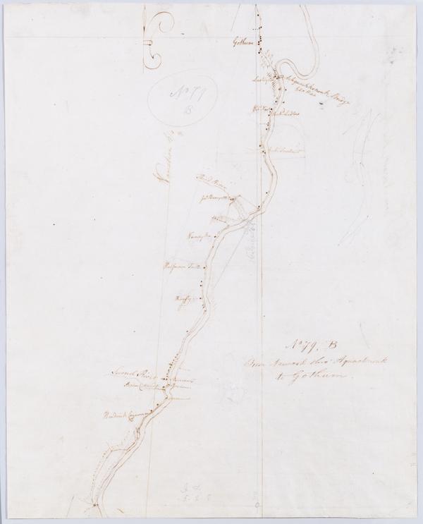
Cartographic From Newark thro' Aquacknonk to Gothum. No 79, B / by Robert Erskine F.R.S. Geogr. A. U.S. and Assistants ; this is Surveyd by Mr. Lodge .... In pencil on recto: "No 79 B". Military topographic map. Covers part of Passaic and Essex counties in New Jersey. Shows roads running through Newark, Belleville and Clifton. Also shows buildings and owners' names, landforms and streams. Pen-and-ink, pencil on laid paper. Shows relief by hachures. Stained, torn and abraded. Mounted on cloth, bound and cropped, disbound and silked by subsequent owners. Cleaned after removal of backings 1999; some fill remains. Sheathed in mylar. Title proper from recto is the work of a later editor--Simeon DeWitt or his assign--subsequent to 1820. View Item
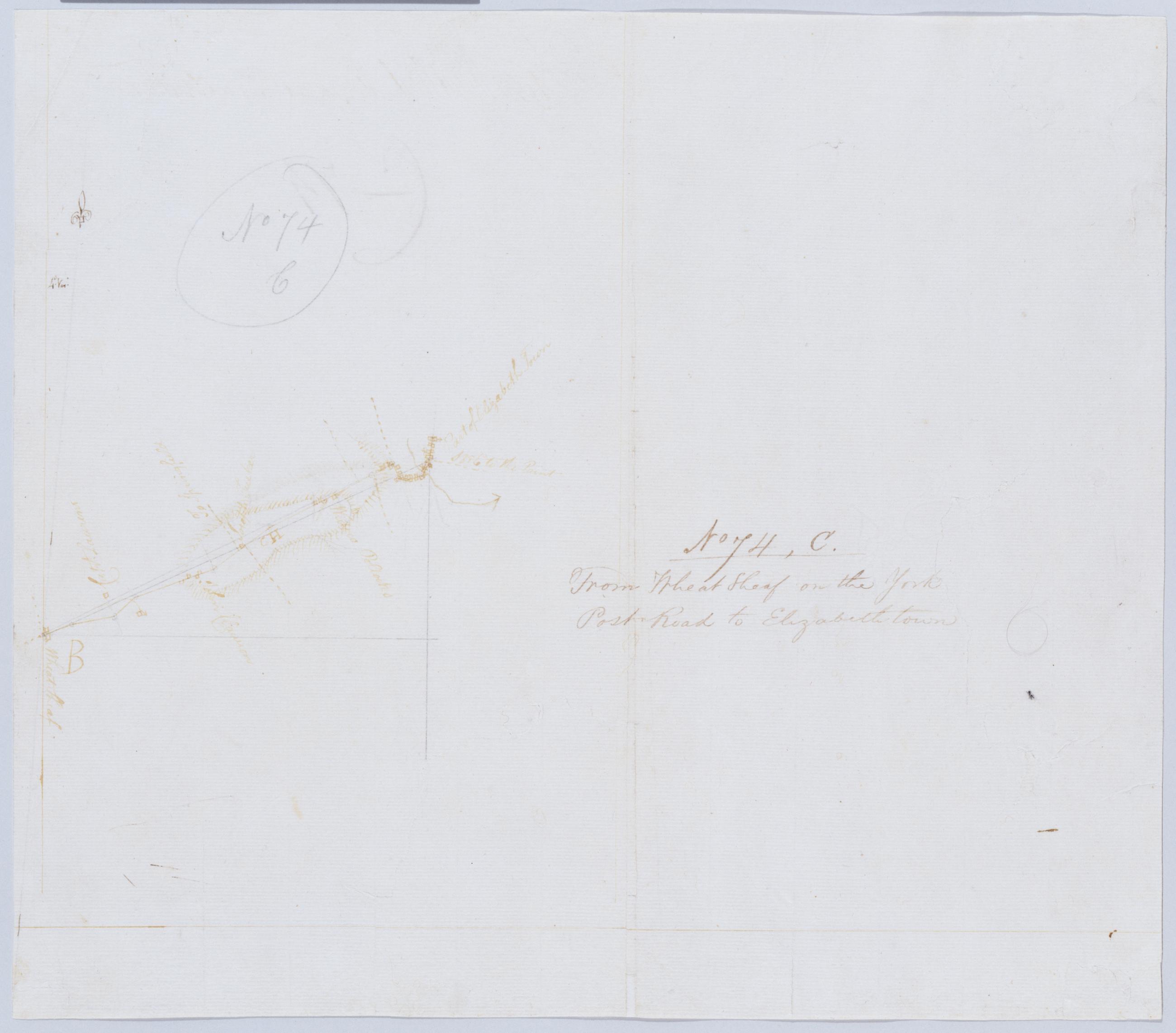
Cartographic From Wheat Sheaf on the York Post Road to Elizabethtown. No 74, C / by Robert Erskine F.R.S. Geogr. A. U.S. and Assistants. In pencil on recto: "No 74 C". Military topographic map. Covers the townships of Union and Linden in Union County, New Jersey. Shows roads running through Wheatsheaf, Linden and Elizabeth. Also shows buildings and owners' names, landforms and streams. Pen-and-ink, pencil on laid paper. Shows relief by hachures. Stained, creased, torn, frayed and abraded. Mounted on cloth, bound and cropped, disbound and silked by subsequent owners. Cleaned after removal of backings 1999; some fill remains. Sheathed in mylar. View Item
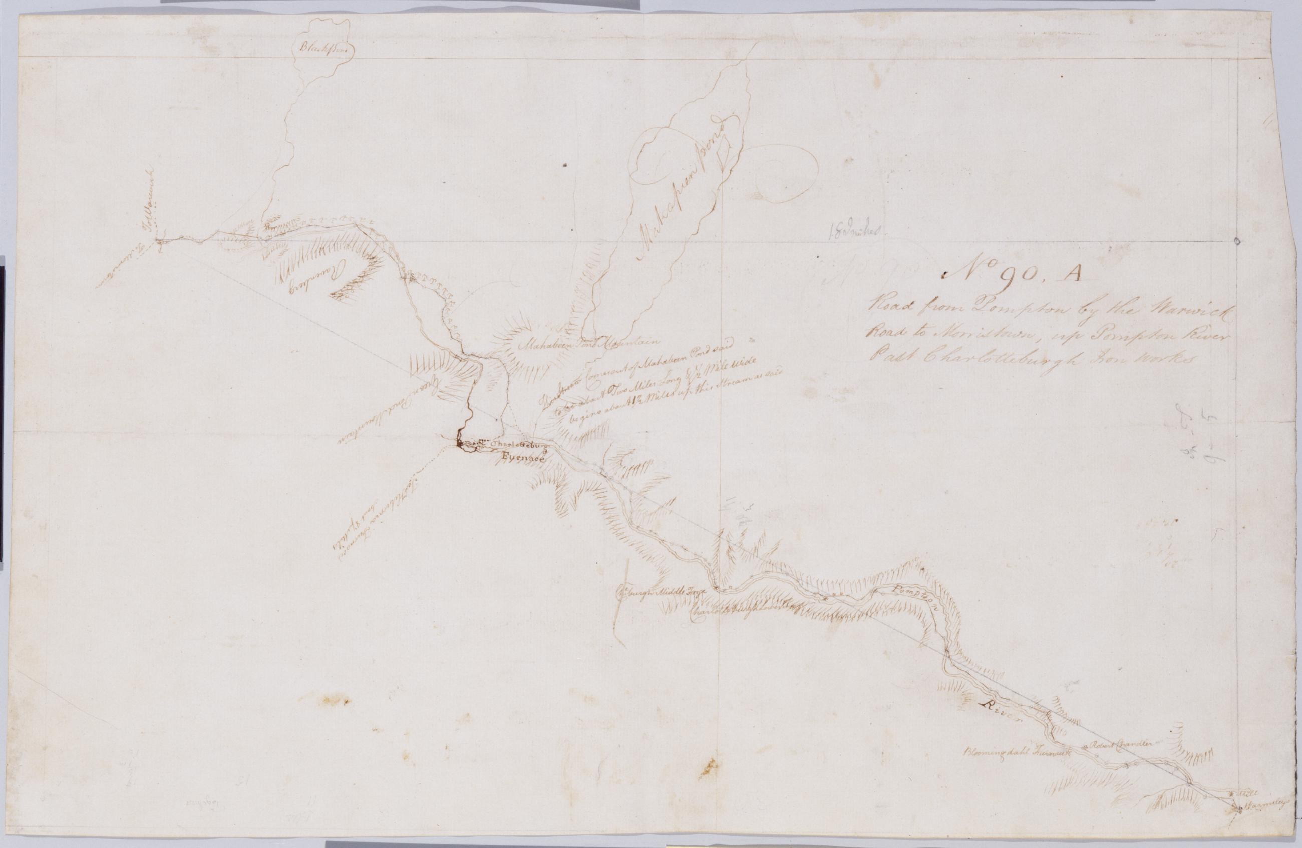
Cartographic Road from Pompton by the Warwick Road to Morristown, up Pompton River Past Charlotteburgh Iron Works No 90, A / by Robert Erskine F.R.S. Geogr. A. U.S. and Assistants. Foxed, soiled, creased and abraded. Mounted on cloth, bound and cropped, disbound and silked by subsequent owners. Cleaned after removal of backings 1999; some fill remains. Sheathed in mylar. In pencil on recto: "No 90 ..." (erased). Military topographic map. Covers the townships of West Milford and Pompton in Passaic County and of Rockaway and Pequanac in Morris County, New Jersey. Shows roads running though Oak Ridge, Newfoundland, Smith Mills and Bloomingdale. Also shows buildings and owners' names, landforms and streams. Pen-and-ink, pencil on laid paper. Shows relief by hachures. View Item
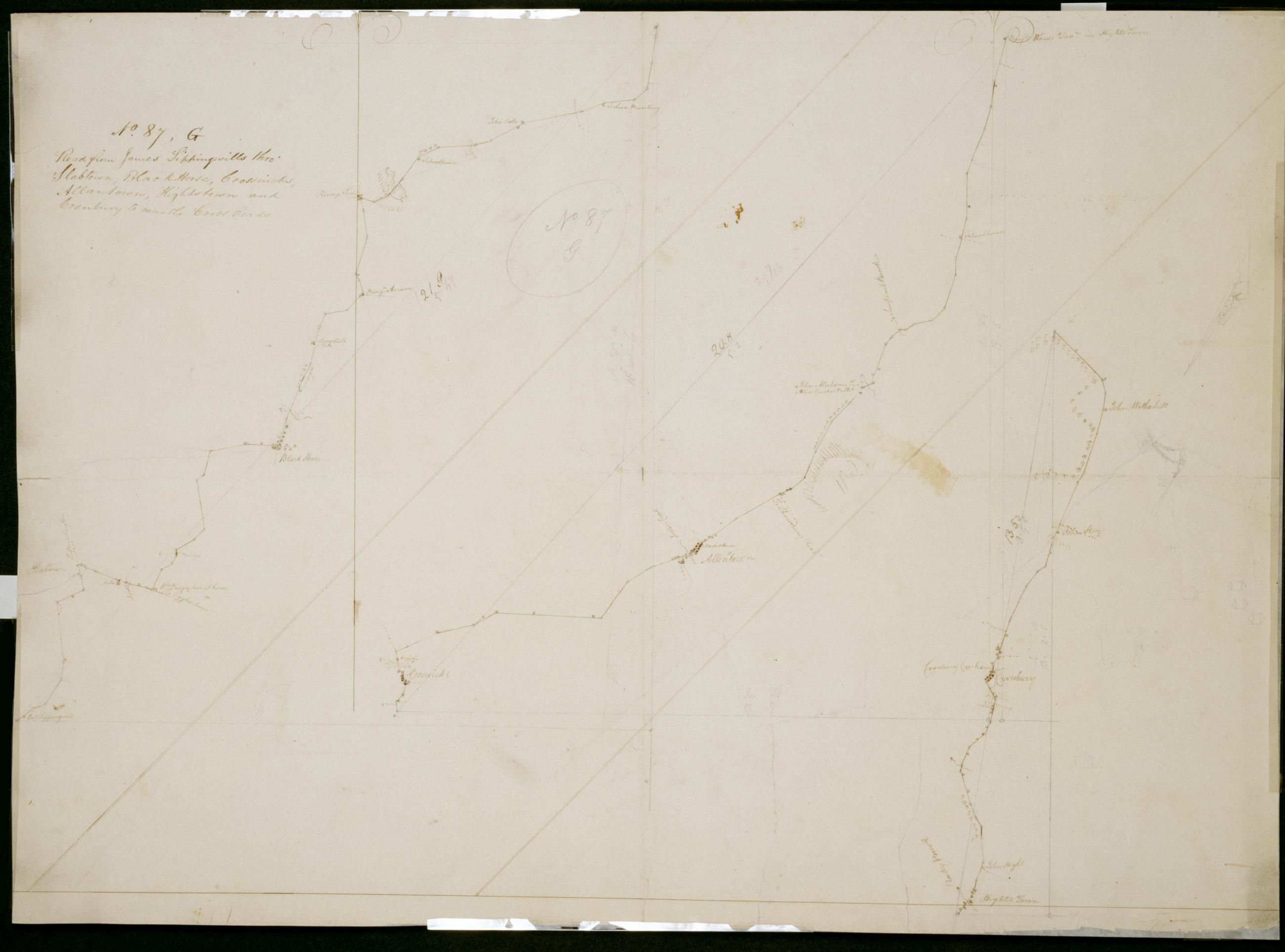
Cartographic Road from James Sippingwills thro' Slabtown, Black Horse, Crosswicks, Allantown, Hightstown and Cranbury to near the Cross Roads. No. 87, G / by Robert Erskine F.R.S. Geogr. A. U.S. and Assistants. In pencil on recto: "No 87 G". Military topographic map in 3 segments; those to right of sheet fit north of the leftmost. Map covers the townships of Chesterfield, Mansfield, Springfield, Easthampton and Hamilton in Burlington County, East Windsor and Washington in Mercer County, and Upper Freehold in Monmouth County, New Jersey. Shows roads running through Mount Holly, Jacksonville, Columbus, Mansfield and Mansfield Square; Crosswicks, Allentown, New Canton and New Sharon; Hightstown and Cranbury. Also shows buildings and owners' names, landforms and streams. View Item
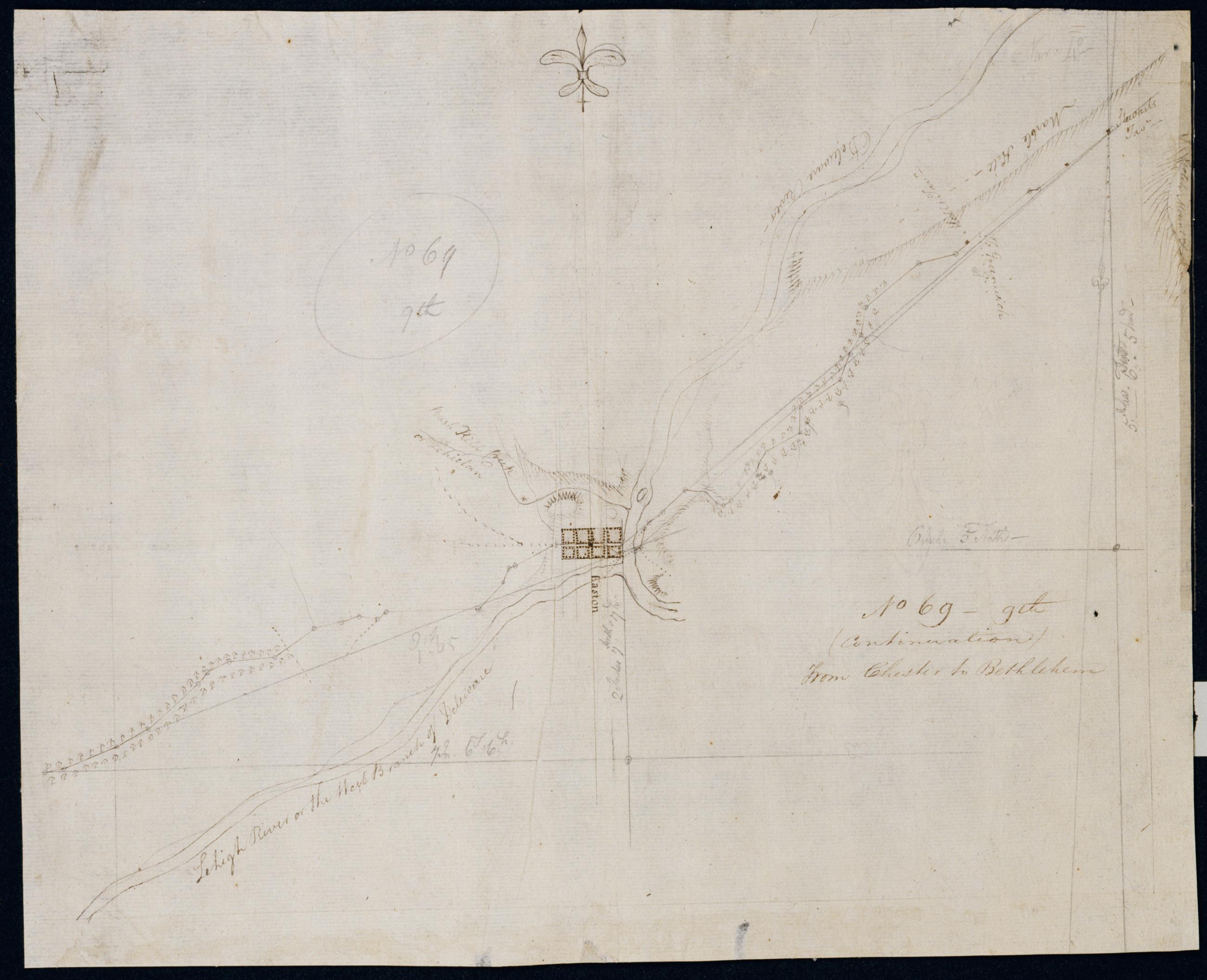
Cartographic (Continuation) From Chester to Bethlehem. No 69-9th / by Robert Erskine F.R.S. Geogr. A. U.S. and Assistants. In pencil on recto: "No 69 9th". Military topographic map. Covers the townships of Harmony and Lopatcong in Warren County, New Jersey, and of Easton and Bethlehem in Northampton County, Pennsylvania. Shows roads running through Phillipsburg, N.J., Easton and Farmersville, Pennsylvania. Also shows buildings and owners' names, landforms and streams. Pen-and-ink, pencil on laid paper. Shows relief by hachures. Stained, creased and abraded. Mounted on cloth, bound and cropped, disbound and silked by subsequent owners. Cleaned after removal of backings 1999; some fill remains. Sheathed in mylar. View Item
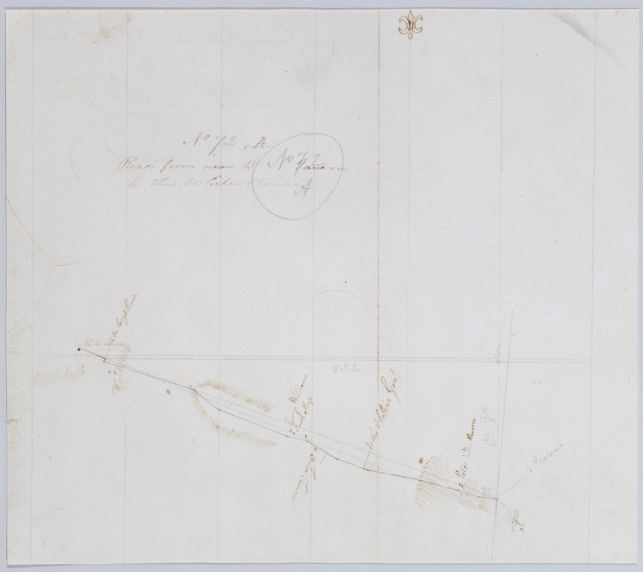
Cartographic Road from near B Tavern to the White House. No 72, A / by Robert Erskine F.R.S. Geogr. A. U.S. and Assistants. Foxed, creased, cracked and abraded. Mounted on cloth, bound and cropped, disbound and silked by subsequent owners. Cleaned after removal of backings 1999; some fill remains. Sheathed in mylar. In pencil on recto: "No 72 A". Military topographic map. Covers the townships of Branchburg and Readington in Hunterdon County, New Jersey. Shows roads running through White House and North Branch. Also shows buildings and owners' names, landforms and streams. Pen-and-ink, pencil on laid paper. Shows relief by hachures. View Item
Cartographic Road from Penny Town to Slack's Ferry and from do. to Trenton and Howell's Ferries. No 87, B / by Robert Erskine F.R.S. Geogr. A. U.S. and Assistants. In ink on verso: "... Howells Ferries No. 87-B" First part of text lost to cropping. In pencil on recto: "No 87 B". Military topographic map. Covers the townships of Ewing and Hopewell in Mercer County, New Jersey. Shows roads running through Pennington, Bear Tavern and Trenton. Also shows buildings and owners' names, landforms and streams. Pen-and-ink, pencil on laid paper. Shows relief by hachures. Soiled, stained, creased, frayed and abraded. Mounted on cloth, bound and cropped, disbound and silked by subsequent owners. Cleaned after removal of backings 1999; some fill remains. View Item
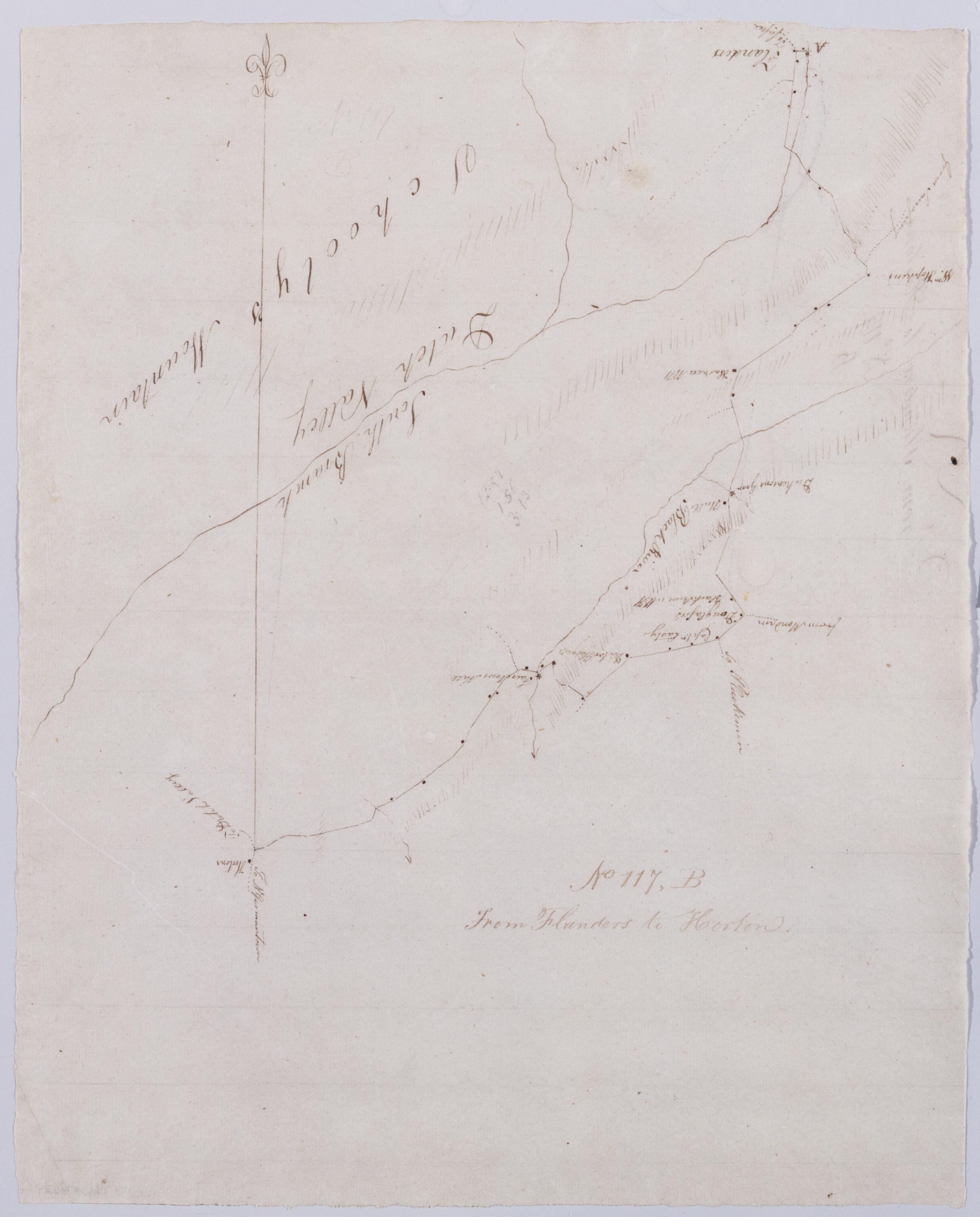
Cartographic From Flanders to Horton. No 117, B / by Robert Erskine F.R.S. Geogr. A. U.S. and Assistants. Drawing attributed to Simeon DeWitt, based on attribution made for sheet 117,A of series. In erased pencil on recto: "No 117 B". Military topographic map. Covers the townships of Mount Olive, Chester, Washington and Parker in Morris County, New Jersey. Shows roads running through Flanders and Chester. Also shows buildings and owners' names, landforms and streams. Pen-and-ink, pencil on laid paper. Shows relief by hachures. Soiled, creased and abraded. Mounted on cloth, bound, disbound and silked by subsequent owners. Cleaned after removal of backings 1999; some fill remains. View Item
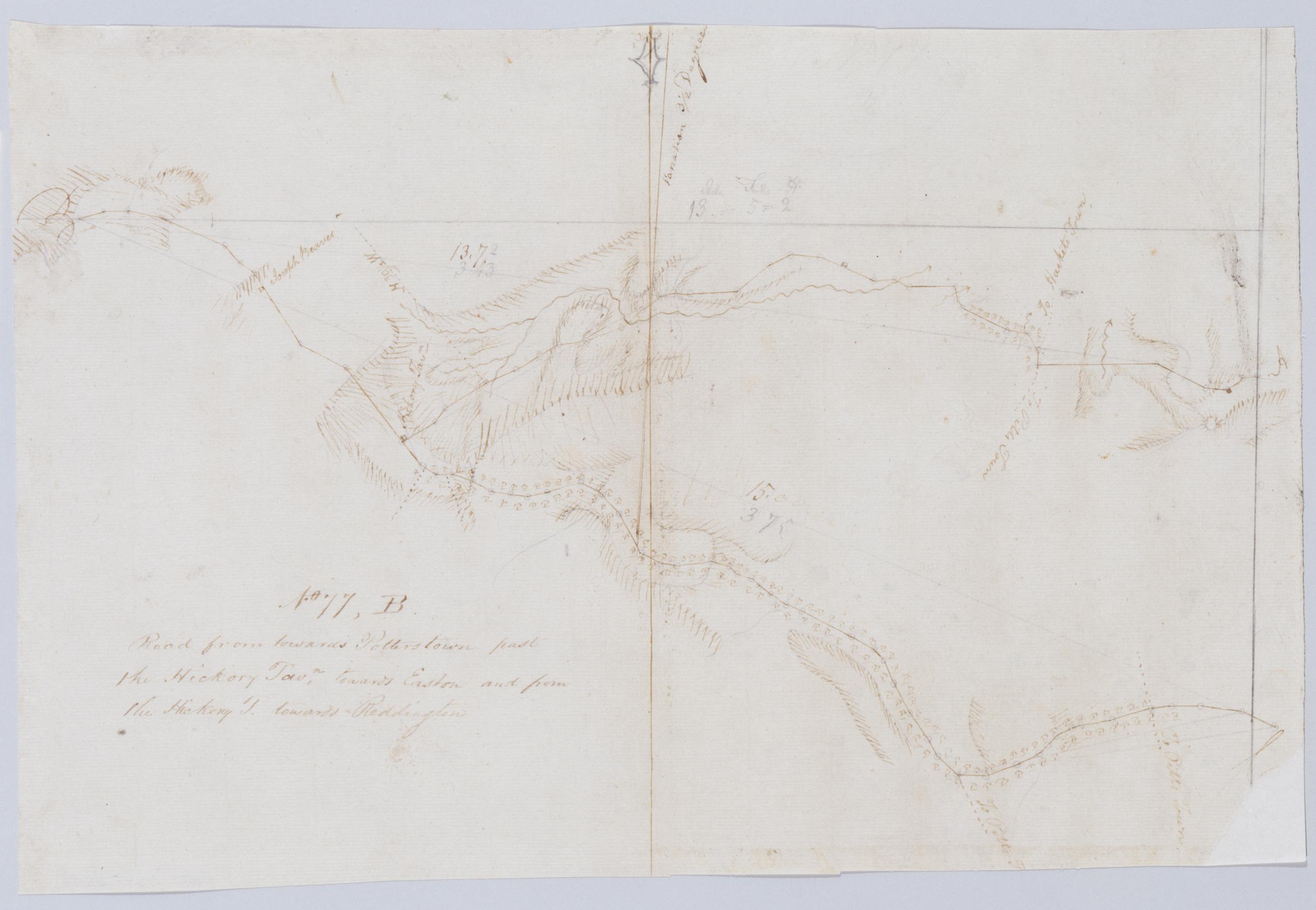
Cartographic Road from towards [sic] Potterstown past the Hickory Tavn, towards Easton and from the Hickory T. toward Reddington No 77, B / by Robert Erskine F.R.S. Geogr. A. U.S. and Assistants. Military topographic map. Covers the townships of Union, Bethlehem and Alexandria in Hunterdon County, New Jersey. Shows roads running through Perryville, The Hickory, Swinesburg, Mechling Corner and Mt. Salem. Also shows buildings and owners' names, landforms and streams. Pen-and-ink, pencil on laid paper. Shows relief by hachures. Soiled, foxed, and abraded. Mounted on cloth, bound and cropped, disbound and silked by subsequent owners. Cleaned after removal of backings 1999; some fill remains. Sheathed in mylar. View Item
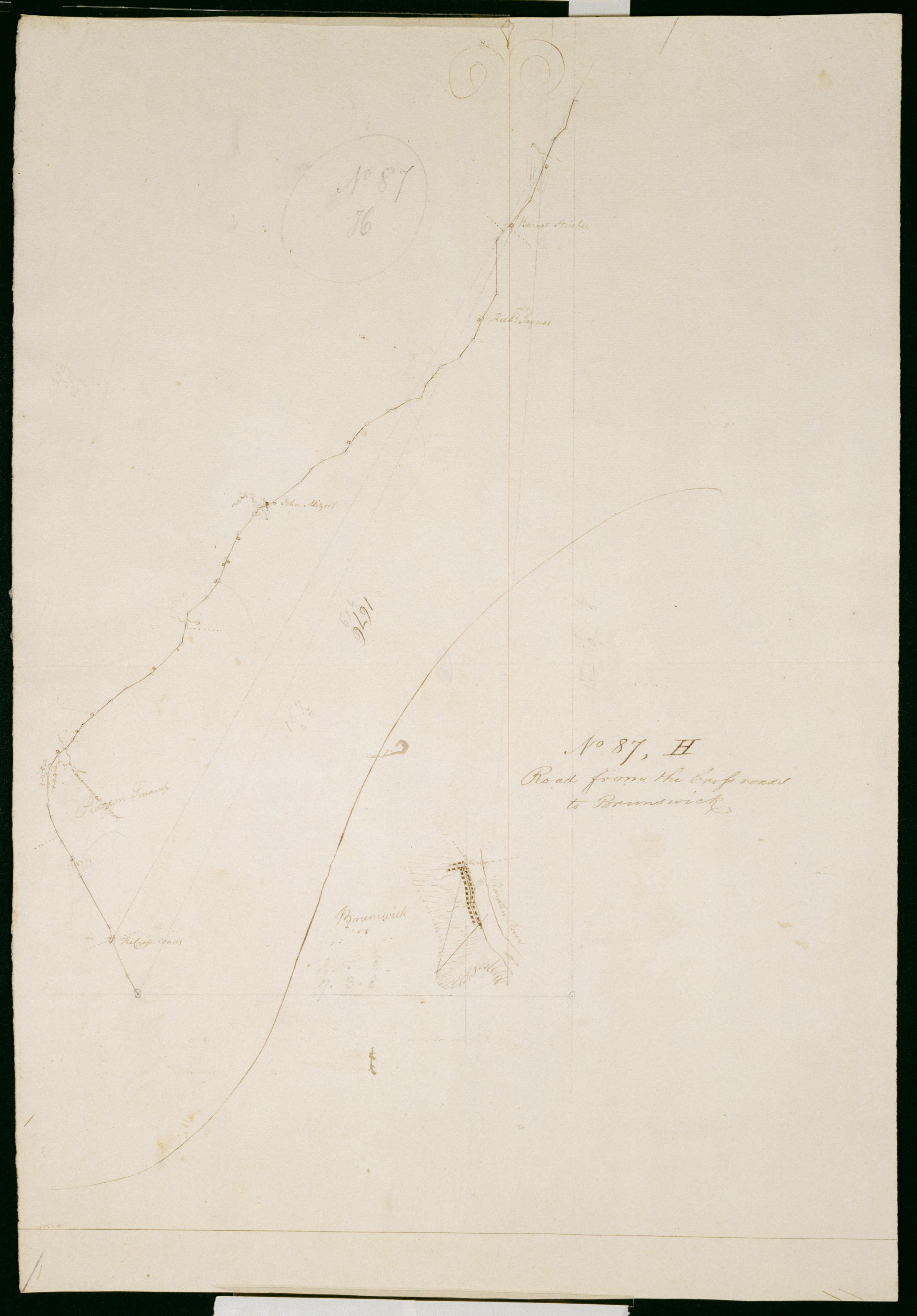
Cartographic Road from the Cross roads to Brunswick. No. 87, H / by Robert Erskine F.R.S. Geogr. A. U.S. and Assistants. In pencil on recto: "No 87 H". Military topographic map. Covers the townships of South Brunswick and North Brunswick in Middlesex County, New Jersey. Shows roads running through Dayton, Deans and New Brunswick. Also shows buildings and owners' names, landforms and streams. Pen-and-ink, pencil on laid paper. Shows relief by hachures. Soiled, stained, creased and abraded. Mounted on cloth, bound, disbound and silked by subsequent owners. Cleaned after removal of backings 1999; some fill remains. Sheathed in mylar. View Item
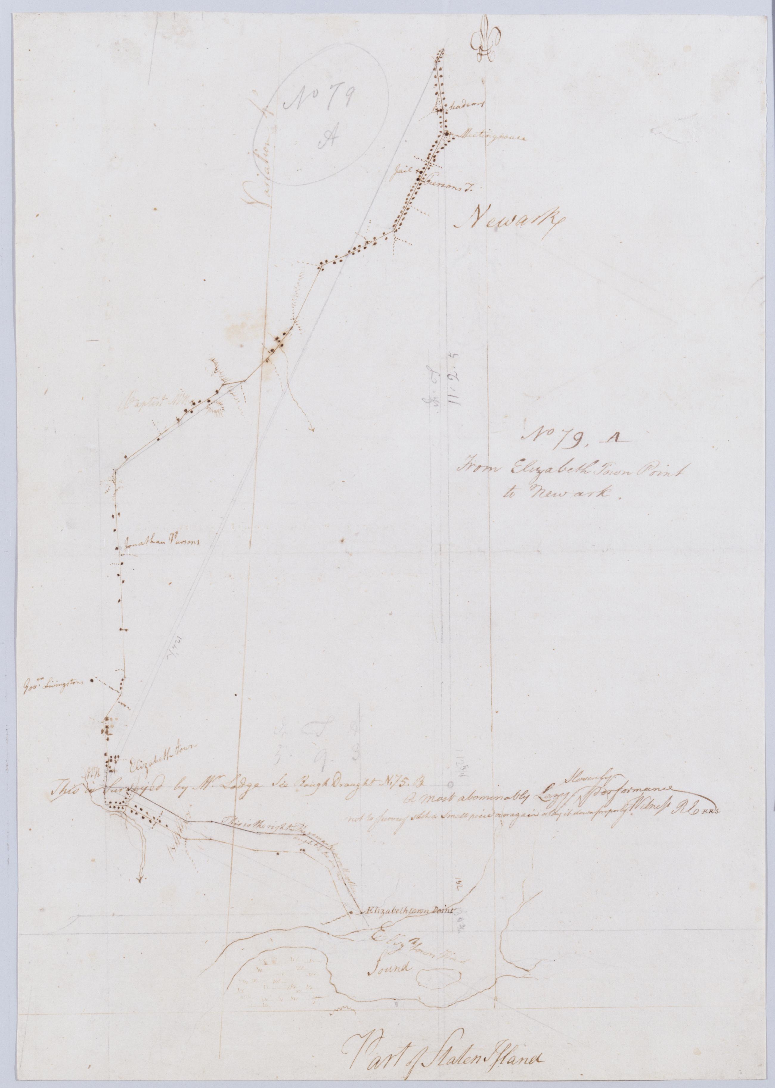
Cartographic From Elizabeth Town Point to Newark. No 79, A / by Robert Erskine F.R.S. Geogr. A. U.S. and Assistants ; this is surveyed by Mr. Lodge .... In ink on verso: "A" Numeral and title cropped off. In pencil on recto: "No 79 A". Includes annotation: "This is surveyed by Mr. Lodge See Rough Draught N.75.B A Most abominably Lazy Slovenly performance not to Survey such a Small piece over again or lay it down properly Witness RE F.R.S." Military topographic map. Covers part of Union and Essex counties in New Jersey. Shows roads running through Elizabeth and Newark. Also shows buildings and owners' names, landforms and streams. Pen-and-ink, pencil on laid paper. Shows relief by hachures. Stained, torn and abraded. View Item
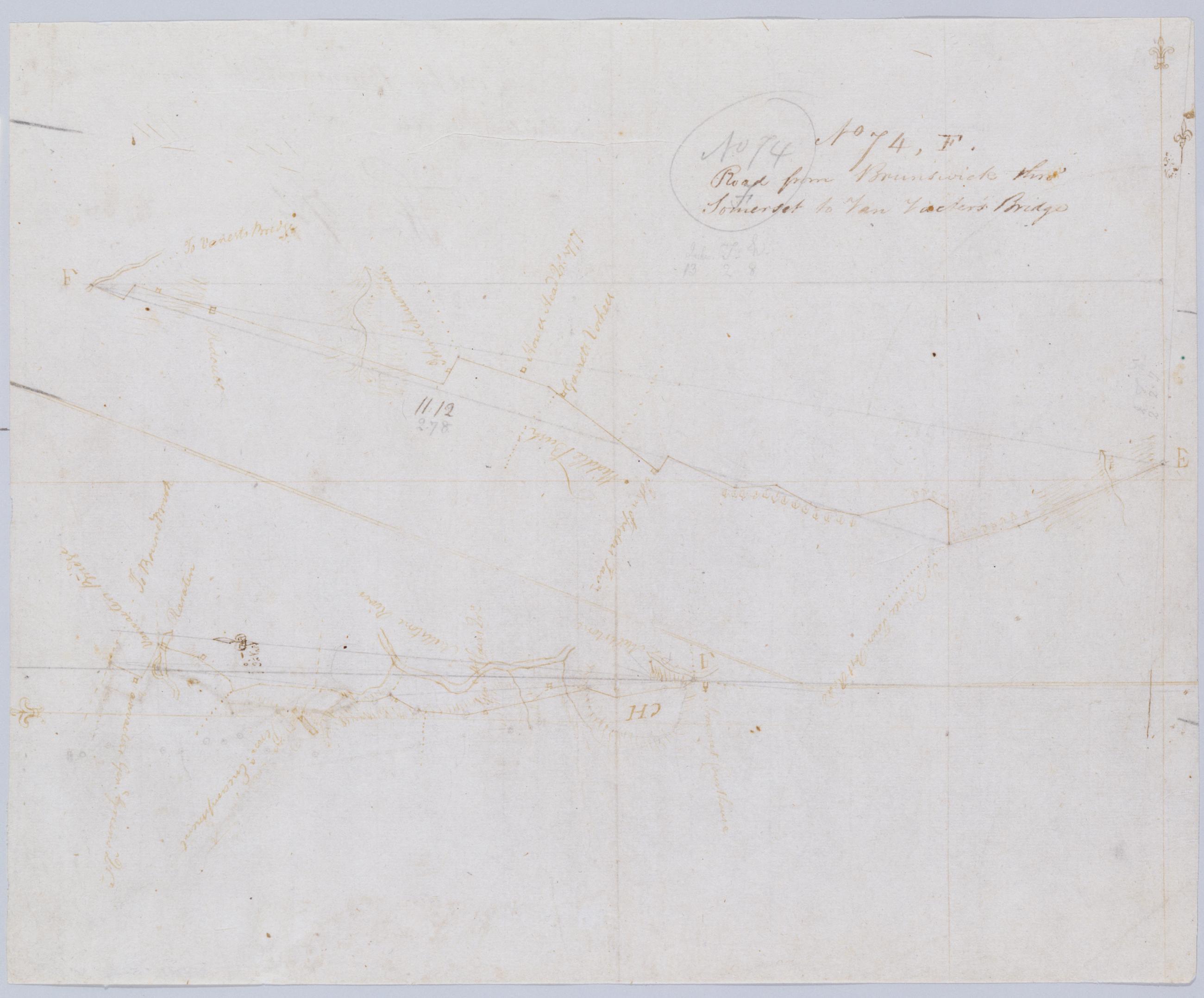
Cartographic Road from Brunswick thro' Somerset to Van Vacter's Bridge. No 74, F / by Robert Erskine F.R.S. Geogr. A. U.S. and Assistants. In pencil on recto: "No 74 F". Military topographic map. Covers the townships of Franklin and Hillsboro in Somerset County, New Jersey. Shows roads running through New Brunswick, Middlebush, East Millstone, Weston and Finderne. Also shows buildings and owners' names, landforms and streams. Pen-and-ink, pencil on laid paper. Shows relief by hachures. Soiled, creased, and abraded. Mounted on cloth, bound and cropped, disbound and silked by subsequent owners. Cleaned after removal of backings 1999; some fill remains. Sheathed in mylar. View Item
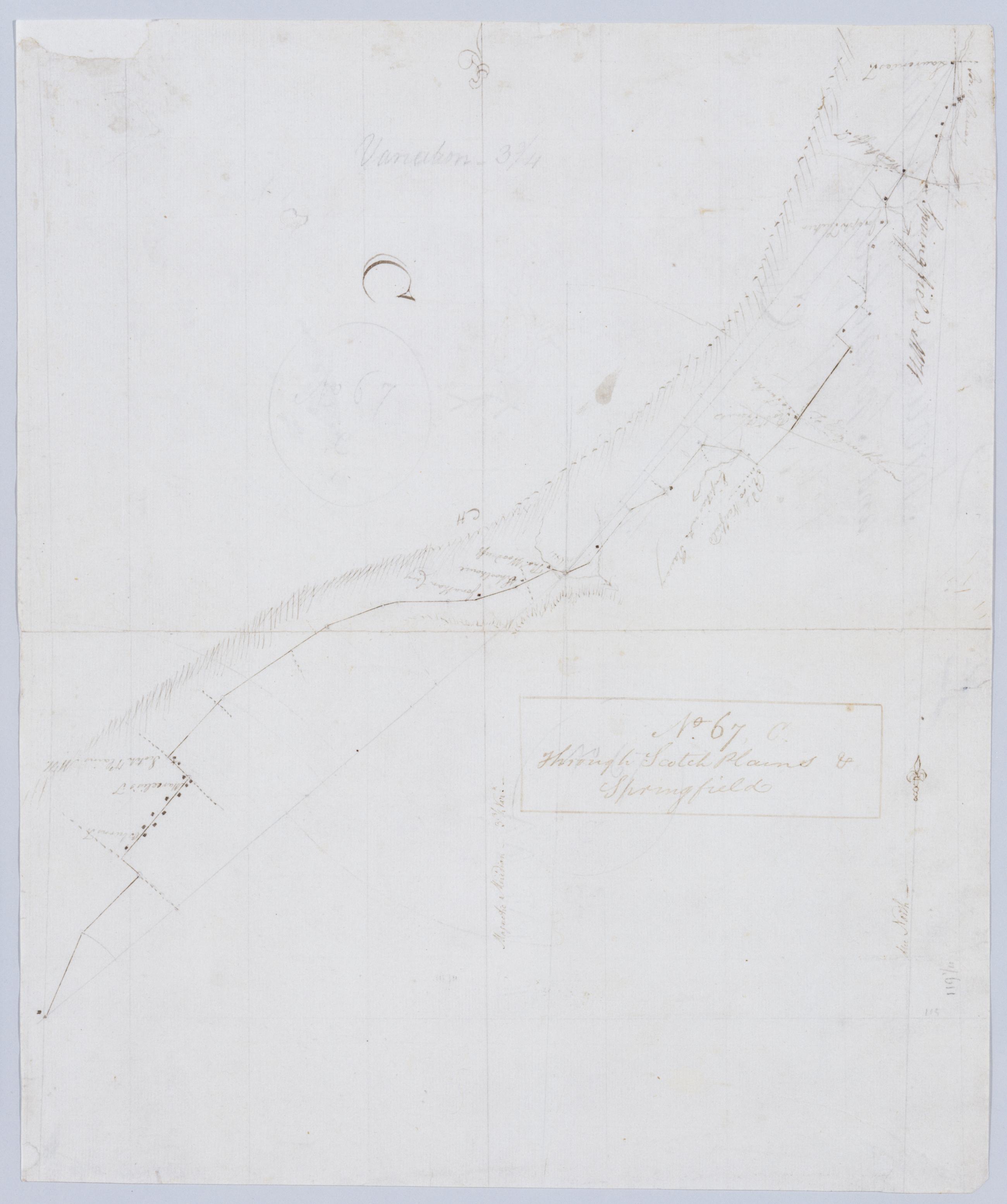
Cartographic Through Scotch Plains & Springfield. No 67, C / by Robert Erskine F.R.S. Geogr. A. U.S. and Assistants. In ink on recto: "C". In pencil on recto:"No 67 C". Military topographic map. Covers the townships of South Orange, Milburn and Union in Essex County and of Springfield, Westfield and Fanwood in Somerset County, New Jersey. Shows roads running though Springfield, Branch Mills, Locust Grove, Scotch Plains and Netherwood. Also shows buildings and owners' names, also landforms and streams. Pen-and-ink, pencil on laid paper. Shows relief by hachures. Stained, creased, frayed and abraded. Mounted on cloth, bound and cropped, disbound and silked by subsequent owners. View Item
Cartographic From Pompton towards Watsessing By the Forks and Little Falls. No 67, A / by Robert Erskine F.R.S. Geogr. A. U.S. and Assistants. Also in ink on verso: "No. 67 A". In ink on recto: "A". Military topographic map. Covers the townships of Wayne and Little Falls in Passaic County and of Caldwell and Milburn in Essex County, New Jersey. Shows roads running through Two Bridges, Little Falls, Cedar Grove and Montclair. Also shows buildings and owners' names, also landforms, streams and wetlands. Pen-and-ink, pencil on laid paper. Shows relief by hachures. Stained, foxed, creased, frayed and abraded. Mounted on cloth, bound and cropped, disbound and silked by subsequent owners. View Item
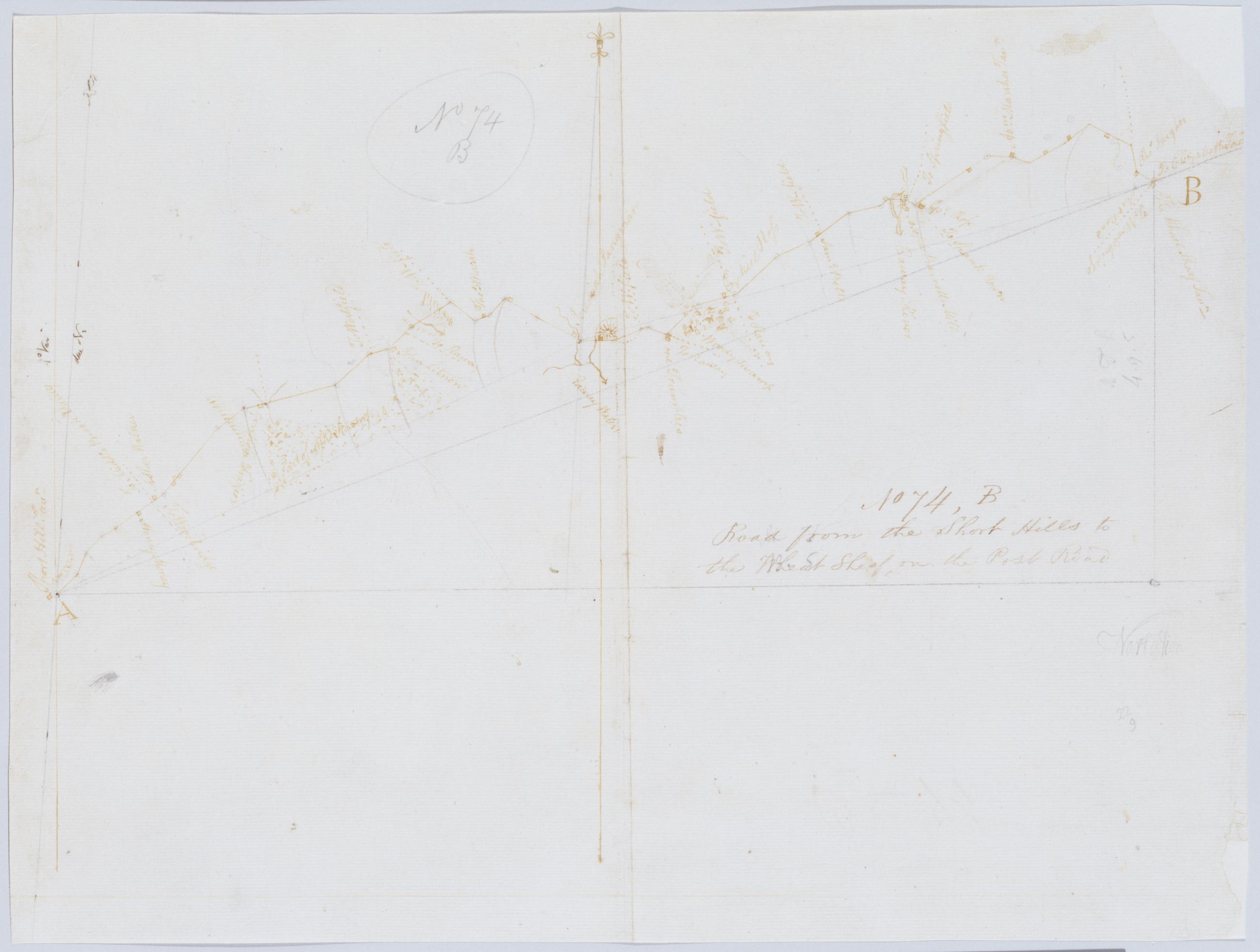
Cartographic Road from the Short Hills to the Wheat Sheaf, on the Post Road. No 74, B / by Robert Erskine F.R.S. Geogr. A. U.S. and Assistants. In pencil on recto: "No 74 B". Military topographic map. Covers the townships of Linden, Clark, Fanwood, Plainfield and Westfield in Union County and of Raritan in Middlesex County, New Jersey. Shows roads running through Willow Grove, Picton and Wheatsheaf. Also shows buildings and owners' names, landforms and streams. Pen-and-ink, pencil on laid paper. Shows relief by hachures. Stained, soiled, creased, torn, frayed and abraded. Mounted on cloth, bound and cropped, disbound and silked by subsequent owners. Cleaned after removal of backings 1999; some fill remains. Sheathed in mylar. View Item