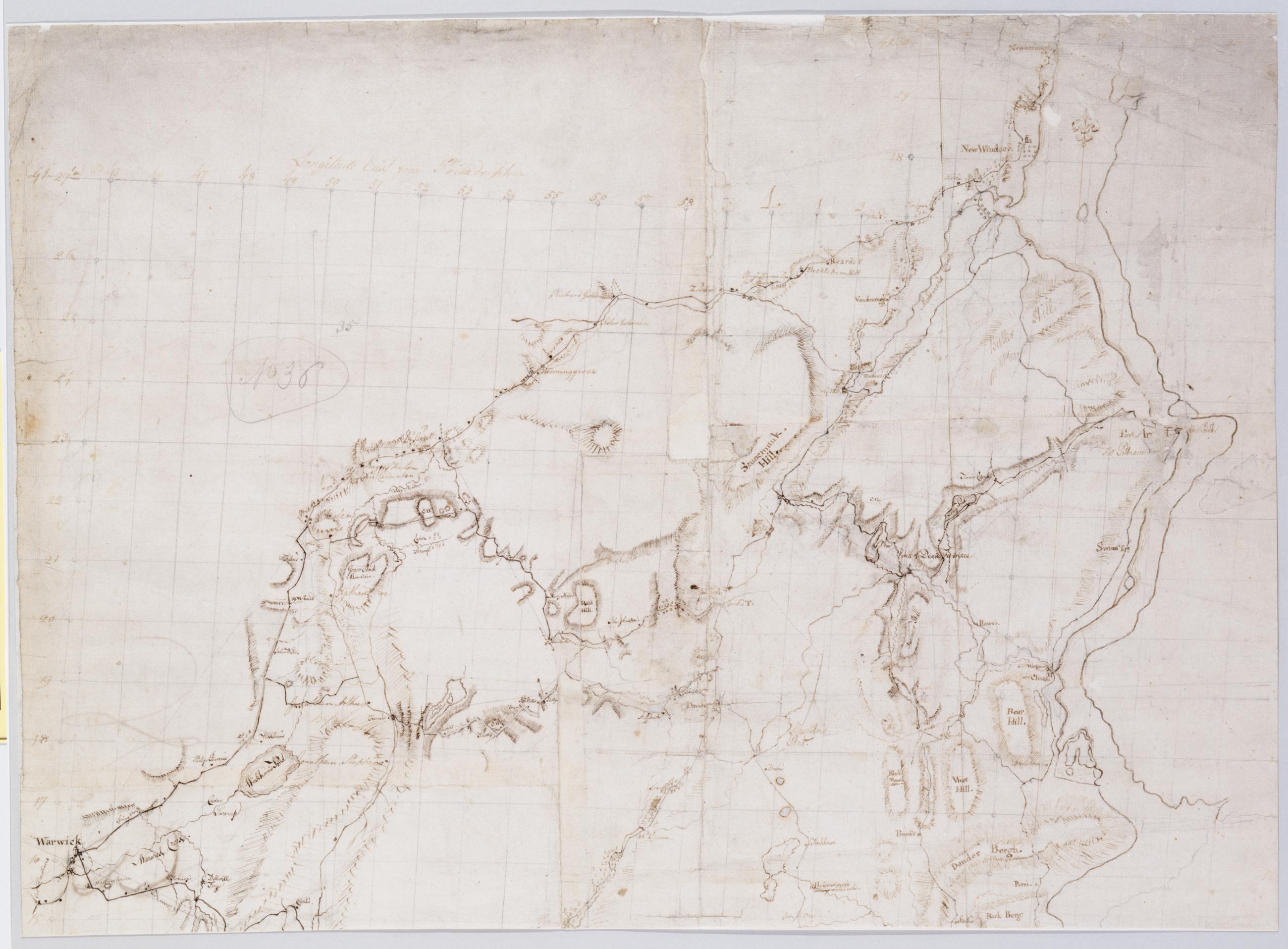
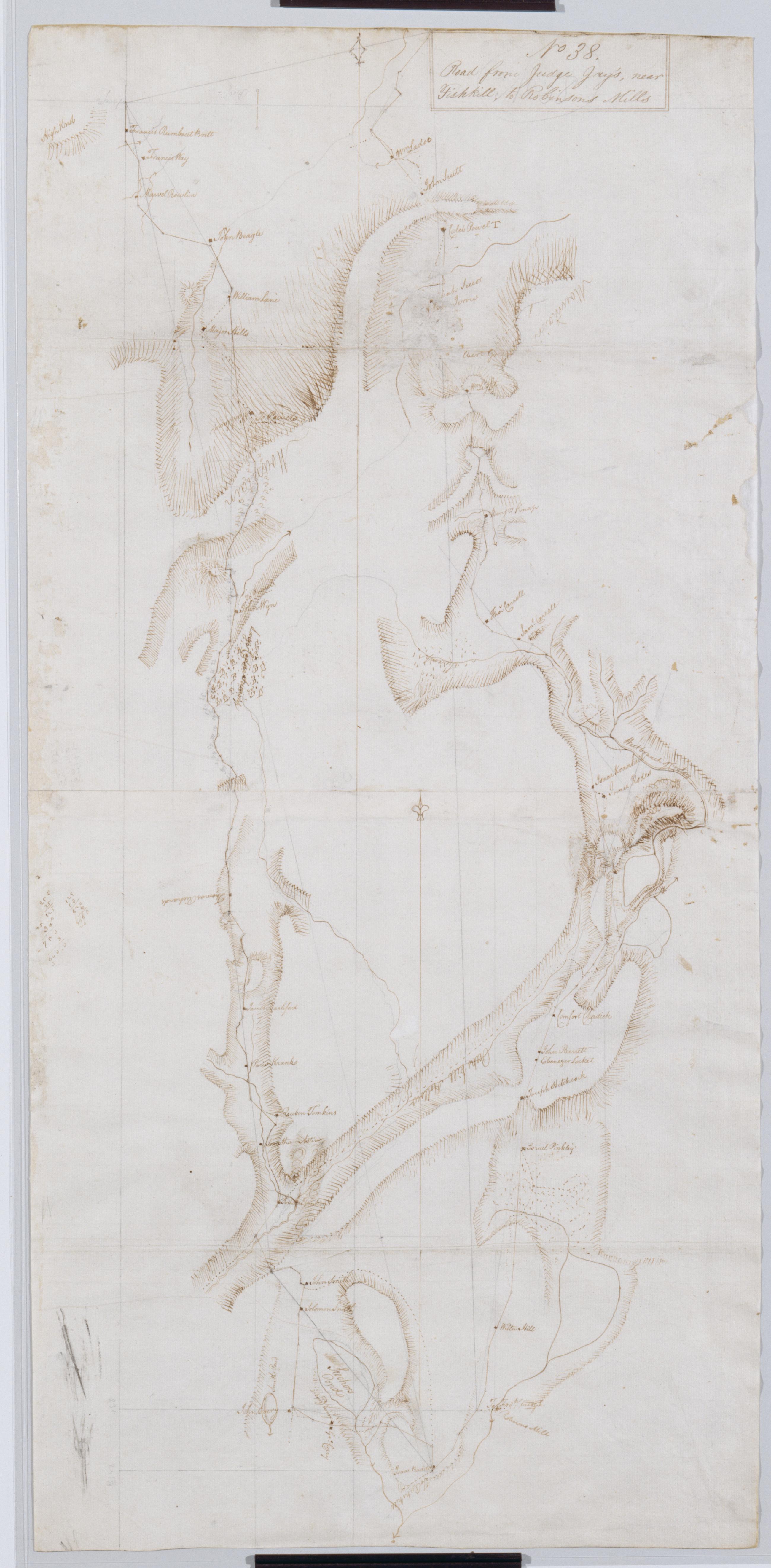
Cartographic Road from Judge Jay's, near Fishkill, to Robinsons Mills. No 38 / by Robert Erskine F.R.S. Geogr. A. U.S. and Assistants. Foxed, creased, frayed, cracked, torn and abraded. Mounted on cloth, bound and cropped, disbound and silked by subsequent owners. Cleaned after removal of backings 1999; some fill remains. Sheathed in mylar. Lined with China paper. In ink on verso: "No. 38". In pencil on recto: "No 38". Military topographic map. Covers the towns of East Fishkill, Carmel, Putnam Valley and Kent in Putnam County, New York. Shows roads running through Hortontown, Wickopee, Tompkins Corners, Mahopac Mines, Mead Corners and East Fishkill. Also shows buildings and owners' names, landforms, wetlands and streams. View Item
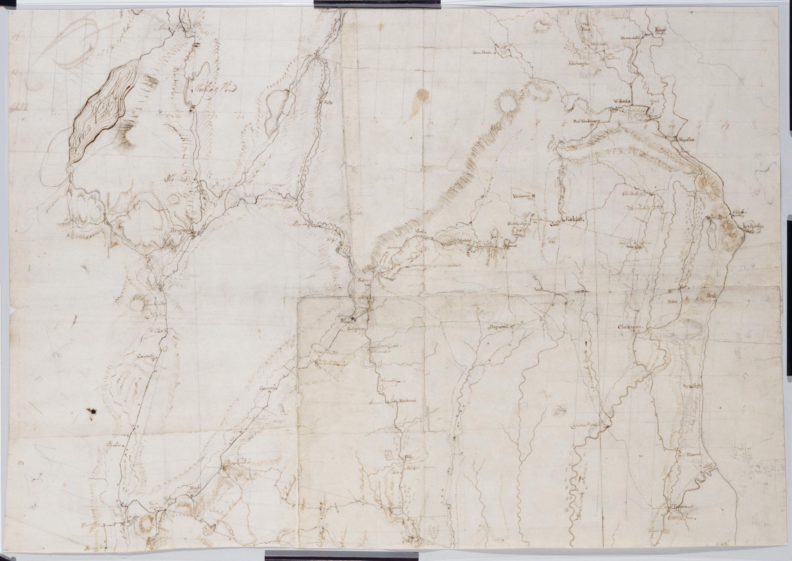
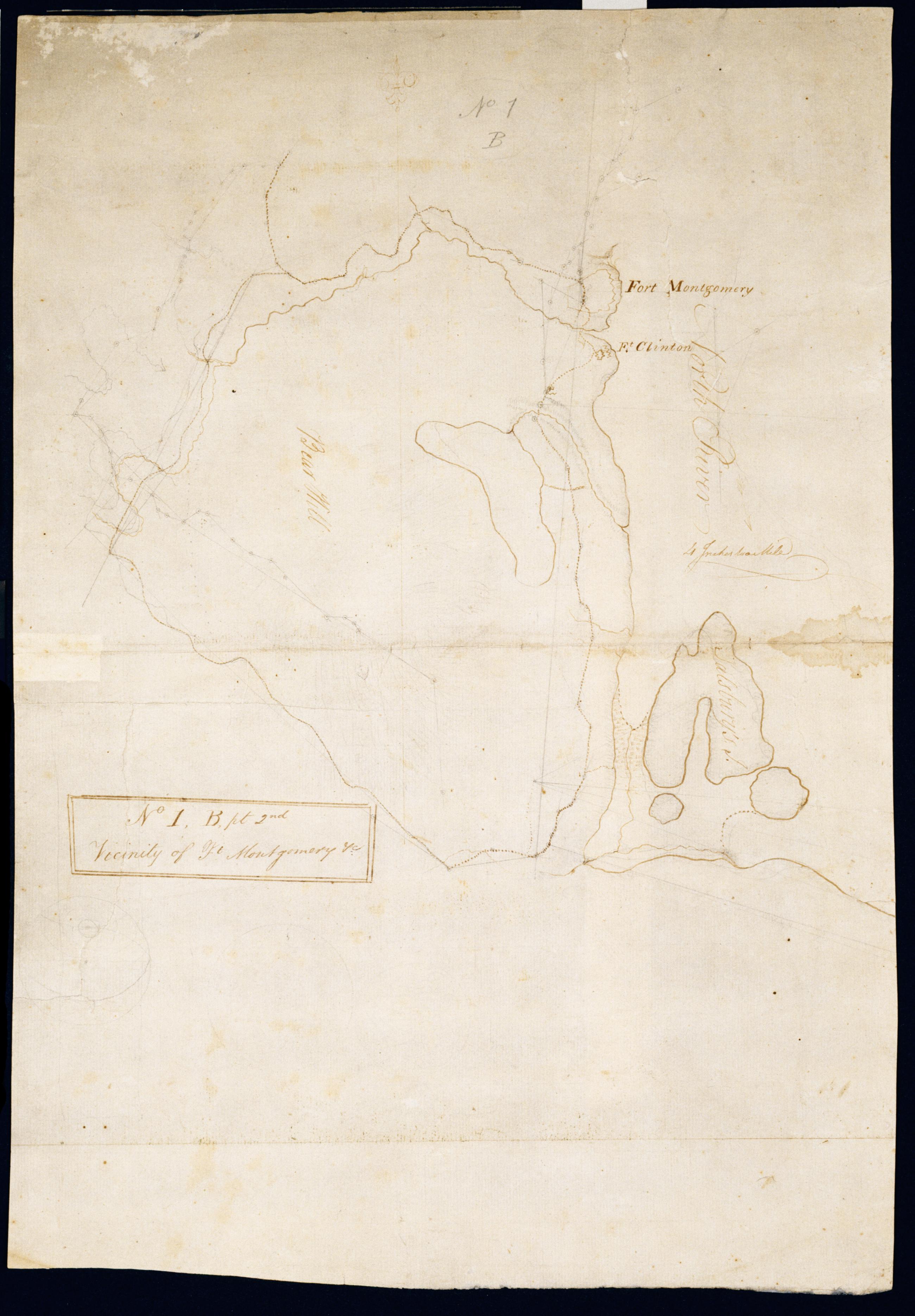
Cartographic Vicinity of Ft Montgomery +c. No 1, B, pt. 2nd / by Robert Erskine F.R.S. Geogr. A. U.S. and Assistants. Foxed, creased, frayed and abraded. Mounted on cloth, bound and cropped, disbound and silked by subsequent owners. Cleaned after removal of backings 1999; some fill remains. Sheathed in mylar. In ink on verso "Part of No. 1 Large Scale N.1.B". In pencil on recto: "No 1 B." Military topographic map. Covers the towns of Stony Point in Rockland County and of Highland and Woodbury in Orange County, New York. Shows roads, forts, landforms, streams and wetlands. Pen-and-ink, pencil on laid paper. Shows relief by hachures. View Item
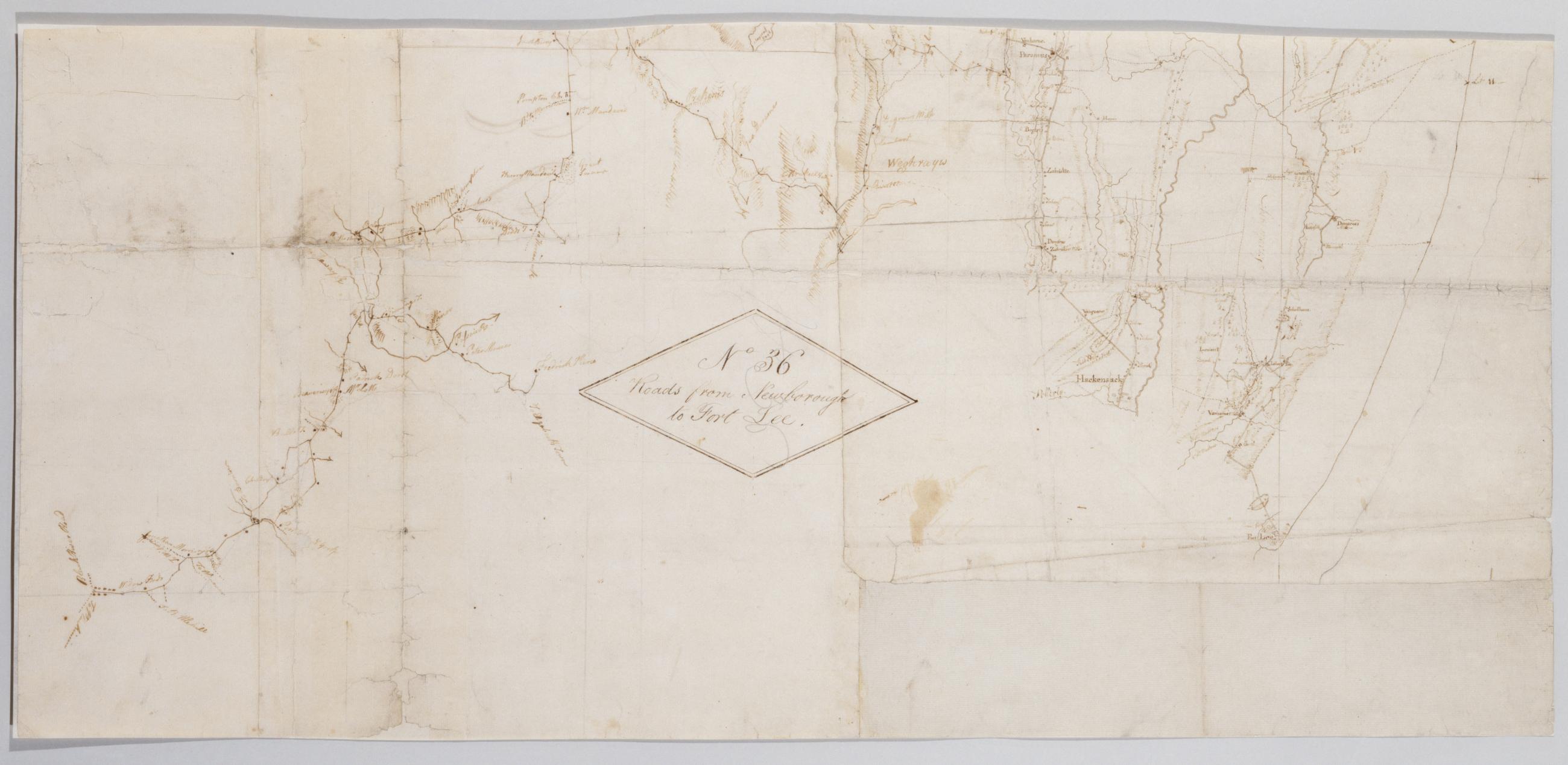
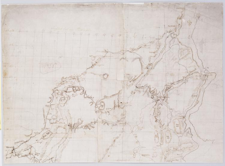
Cartographic Roads from Newborough to Fort Lee. No 36 / by Robert Erskine F.R.S. Geogr. A. U.S. and Assistants, bottom Military topographic map. Covers Orange and Rockland Counties in New York and Bergen, Passaic, Morris and Essex Counties in New Jersey. Shows roads, buildings and owners' names, also landforms, wetlands and streams. Shows relief by hachures. Title proper from recto is the work of a later editor--Simeon DeWitt or his assign--subsequent to 1820. Index title, statement of responsibility, date, series title and series numbering also by Erskine, but on separate index sheet filed at head of series. Pen-and-ink, pencil on laid paper. View Item
Cartographic Roads from Newborough to Fort Lee. No 36 / by Robert Erskine F.R.S. Geogr. A. U.S. and Assistants, top Military topographic map. Covers Orange and Rockland Counties in New York and Bergen, Passaic, Morris and Essex Counties in New Jersey. Shows roads, buildings and owners' names, also landforms, wetlands and streams. Shows relief by hachures. Title proper from recto is the work of a later editor--Simeon DeWitt or his assign--subsequent to 1820. Index title, statement of responsibility, date, series title and series numbering also by Erskine, but on separate index sheet filed at head of series. Pen-and-ink, pencil on laid paper. View Item
Cartographic Roads from Newborough to Fort Lee. No 36 / by Robert Erskine F.R.S. Geogr. A. U.S. and Assistants, center Military topographic map. Covers Orange and Rockland Counties in New York and Bergen, Passaic, Morris and Essex Counties in New Jersey. Shows roads, buildings and owners' names, also landforms, wetlands and streams. Shows relief by hachures. Title proper from recto is the work of a later editor--Simeon DeWitt or his assign--subsequent to 1820. Index title, statement of responsibility, date, series title and series numbering also by Erskine, but on separate index sheet filed at head of series. Pen-and-ink, pencil on laid paper. View Item
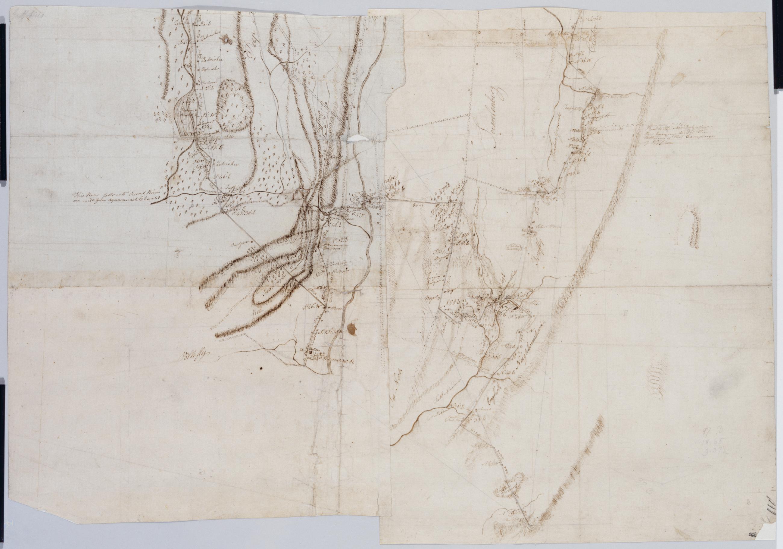
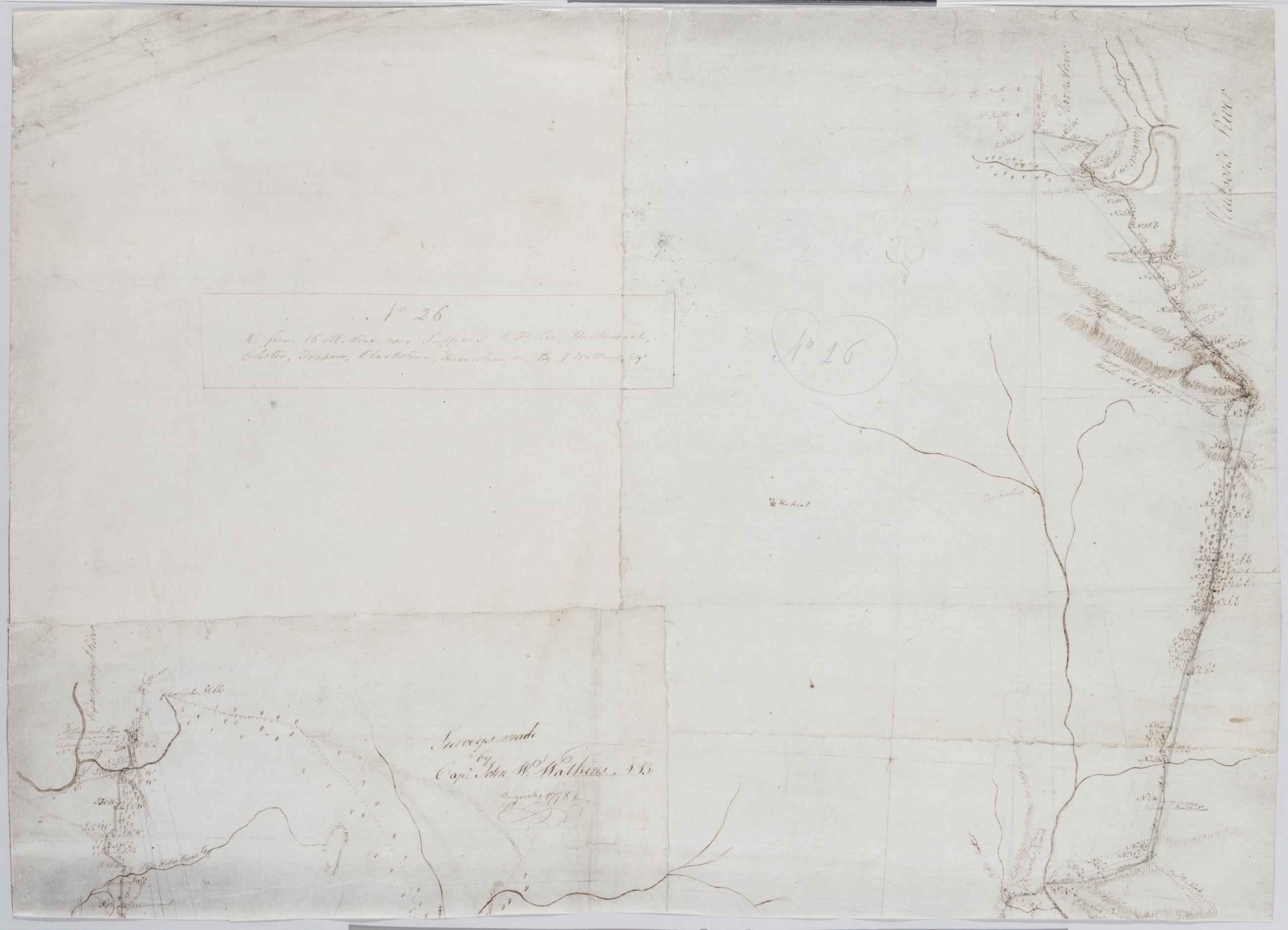
Cartographic R. from 15 M. stone, near Suffran's to Ft Lee, Hackensack, Closter, Tappan, Clarkstown, Haverstraw +c. No 26 / by J. Watkins Esqr ; surveys made by Capt: John W: Watkins A:B: ; by Robert Erskine F.R.S. Geogr. A. U.S. and Assistants, bottom Military topographic map. Covers most of Rockland County, New York, and Bergen County, New Jersey. Shows roads running through Suffern, Saddle River, Paramus and Hackensack, as well as Haverstraw, Clarksville, Tappan, Tenefly and Closter. Also shows buildings and owners' names, landforms, ground cover, wetlands and streams. Shows relief by hachures. Title proper and first statement of responsibility from recto are the work of a later editor--Simeon DeWitt or his assign--subsequent to 1820. Second statement of responsibility and detailed date also from apparently written by Watkins. View Item
Cartographic R. from 15 M. stone, near Suffran's to Ft Lee, Hackensack, Closter, Tappan, Clarkstown, Haverstraw +c. No 26 / by J. Watkins Esqr ; surveys made by Capt: John W: Watkins A:B: ; by Robert Erskine F.R.S. Geogr. A. U.S. and Assistants, top Military topographic map. Covers most of Rockland County, New York, and Bergen County, New Jersey. Shows roads running through Suffern, Saddle River, Paramus and Hackensack, as well as Haverstraw, Clarksville, Tappan, Tenefly and Closter. Also shows buildings and owners' names, landforms, ground cover, wetlands and streams. Shows relief by hachures. Title proper and first statement of responsibility from recto are the work of a later editor--Simeon DeWitt or his assign--subsequent to 1820. Second statement of responsibility and detailed date also from apparently written by Watkins. View Item
Cartographic R. from 15 M. stone, near Suffran's to Ft Lee, Hackensack, Closter, Tappan, Clarkstown, Haverstraw +c. No 26 / by J. Watkins Esqr ; surveys made by Capt: John W: Watkins A:B: ; by Robert Erskine F.R.S. Geogr. A. U.S. and Assistants, center Military topographic map. Covers most of Rockland County, New York, and Bergen County, New Jersey. Shows roads running through Suffern, Saddle River, Paramus and Hackensack, as well as Haverstraw, Clarksville, Tappan, Tenefly and Closter. Also shows buildings and owners' names, landforms, ground cover, wetlands and streams. Shows relief by hachures. Title proper and first statement of responsibility from recto are the work of a later editor--Simeon DeWitt or his assign--subsequent to 1820. Second statement of responsibility and detailed date also from apparently written by Watkins. View Item
Image Cartographic 3 Items Roads from Newborough to Fort Lee. No 36 / by Robert Erskine F.R.S. Geogr. A. U.S. and Assistants. Military topographic map. Covers Orange and Rockland Counties in New York and Bergen, Passaic, Morris and Essex Counties in New Jersey. Shows roads, buildings and owners' names, also landforms, wetlands and streams. Shows relief by hachures. Title proper from recto is the work of a later editor--Simeon DeWitt or his assign--subsequent to 1820. Index title, statement of responsibility, date, series title and series numbering also by Erskine, but on separate index sheet filed at head of series. Pen-and-ink, pencil on laid paper. View Item
Image Cartographic 3 Items R. from 15 M. stone, near Suffran's to Ft Lee, Hackensack, Closter, Tappan, Clarkstown, Haverstraw +c. No 26 / by J. Watkins Esqr ; surveys made by Capt: John W: Watkins A:B: ; by Robert Erskine F.R.S. Geogr. A. U.S. and Assistants. Military topographic map. Covers most of Rockland County, New York, and Bergen County, New Jersey. Shows roads running through Suffern, Saddle River, Paramus and Hackensack, as well as Haverstraw, Clarksville, Tappan, Tenefly and Closter. Also shows buildings and owners' names, landforms, ground cover, wetlands and streams. Shows relief by hachures. Title proper and first statement of responsibility from recto are the work of a later editor--Simeon DeWitt or his assign--subsequent to 1820. Second statement of responsibility and detailed date also from apparently written by Watkins. View Item
Cartographic Road from Judge Jay's near Fishkill to Robinsons Mills. No 38 / by Robert Erskine F.R.S. Geogr. A. U.S. and Assistants. Foxed- creased- frayed- cracked- torn and abraded. Mounted on cloth- bound and cropped- disbound and silked by subsequent owners. Cleaned after removal of backings 1999; some fill remains. Sheathed in mylar. Lined with China paper. In ink on verso: "No. 38". In pencil on recto: "No 38". Military topographic map. Covers the towns of East Fishkill- Carmel- Putnam Valley and Kent in Putnam County- New York. Shows roads running through Hortontown- Wickopee- Tompkins Corners- Mahopac Mines- Mead Corners and East Fishkill. Also shows buildings and owners' names- landforms- wetlands and streams. View Item
Cartographic Vicinity of Ft Montgomery +c. No 1 B pt. 2nd / by Robert Erskine F.R.S. Geogr. A. U.S. and Assistants. Foxed- creased- frayed and abraded. Mounted on cloth- bound and cropped- disbound and silked by subsequent owners. Cleaned after removal of backings 1999; some fill remains. Sheathed in mylar. In ink on verso "Part of No. 1 Large Scale N.1.B". In pencil on recto: "No 1 B." Military topographic map. Covers the towns of Stony Point in Rockland County and of Highland and Woodbury in Orange County- New York. Shows roads- forts- landforms- streams and wetlands. Pen-and-ink- pencil on laid paper. Shows relief by hachures. View Item
Cartographic Roads from Newborough to Fort Lee. No 36 / by Robert Erskine F.R.S. Geogr. A. U.S. and Assistants. Military topographic map. Covers Orange and Rockland Counties in New York and Bergen- Passaic- Morris and Essex Counties in New Jersey. Shows roads- buildings and owners' names- also landforms- wetlands and streams. Shows relief by hachures. Title proper from recto is the work of a later editor--Simeon DeWitt or his assign--subsequent to 1820. Index title- statement of responsibility- date- series title and series numbering also by Erskine- but on separate index sheet filed at head of series. Pen-and-ink- pencil on laid paper. View Item
Cartographic R. from 15 M. stone near Suffran's to Ft Lee Hackensack Closter Tappan Clarkstown Haverstraw +c. No 26 / by J. Watkins Esqr ; surveys made by Capt: John W: Watkins A:B: ; by Robert Erskine F.R.S. Geogr. A. U.S. and Assistants. Military topographic map. Covers most of Rockland County- New York- and Bergen County- New Jersey. Shows roads running through Suffern- Saddle River- Paramus and Hackensack- as well as Haverstraw- Clarksville- Tappan- Tenefly and Closter. Also shows buildings and owners' names- landforms- ground cover- wetlands and streams. Shows relief by hachures. Title proper and first statement of responsibility from recto are the work of a later editor--Simeon DeWitt or his assign--subsequent to 1820. Second statement of responsibility and detailed date also from apparently written by Watkins. View Item