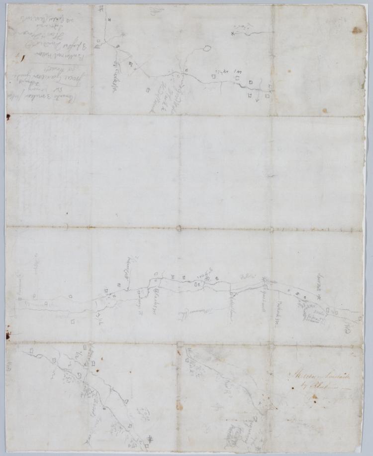
Cartographic Road from Kembles to Chatham. No 104, A / by Robert Erskine F.R.S. Geogr. A. U.S. and Assistants. Foxed, creased, frayed and abraded. Mounted on cloth, bound and cropped, disbound and silked by subsequent owners. Cleaned after removal of backings 1999; some fill remains. Sheathed in mylar. In pencil on recto: "No 104 A". Military topographic map. Covers the townships of Passaic and Morris in Morris County and of Bernard in Somerset County, New Jersey. Shows roads running through Chatham, Morristown, Logansville, Millington and Liberty Corner. Also shows buildings and owners' names, landforms and streams. Pen-and-ink, pencil on laid paper. Shows relief by hachures. View Item
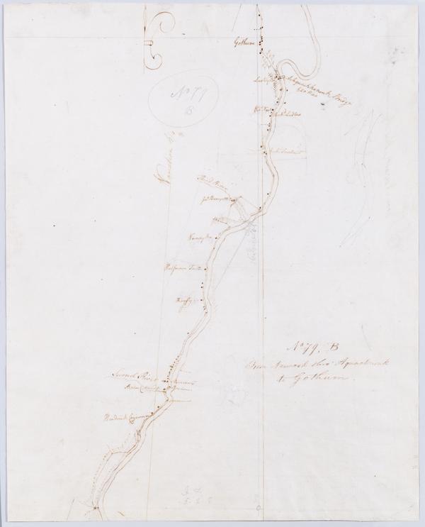
Cartographic From Newark thro' Aquacknonk to Gothum. No 79, B / by Robert Erskine F.R.S. Geogr. A. U.S. and Assistants ; this is Surveyd by Mr. Lodge .... In pencil on recto: "No 79 B". Military topographic map. Covers part of Passaic and Essex counties in New Jersey. Shows roads running through Newark, Belleville and Clifton. Also shows buildings and owners' names, landforms and streams. Pen-and-ink, pencil on laid paper. Shows relief by hachures. Stained, torn and abraded. Mounted on cloth, bound and cropped, disbound and silked by subsequent owners. Cleaned after removal of backings 1999; some fill remains. Sheathed in mylar. Title proper from recto is the work of a later editor--Simeon DeWitt or his assign--subsequent to 1820. View Item
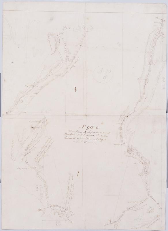
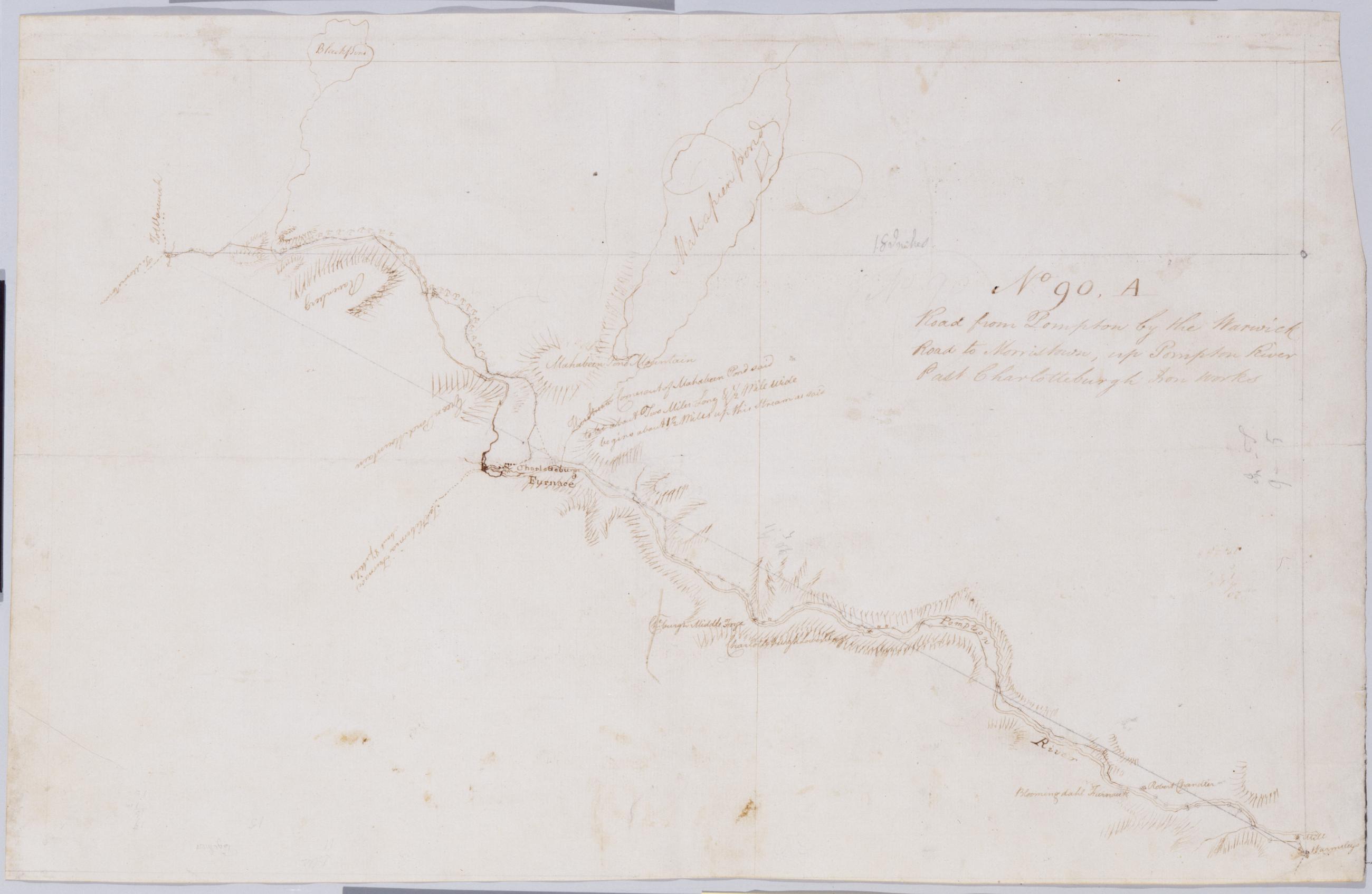
Cartographic Road from Pompton by the Warwick Road to Morristown, up Pompton River Past Charlotteburgh Iron Works No 90, A / by Robert Erskine F.R.S. Geogr. A. U.S. and Assistants. Foxed, soiled, creased and abraded. Mounted on cloth, bound and cropped, disbound and silked by subsequent owners. Cleaned after removal of backings 1999; some fill remains. Sheathed in mylar. In pencil on recto: "No 90 ..." (erased). Military topographic map. Covers the townships of West Milford and Pompton in Passaic County and of Rockaway and Pequanac in Morris County, New Jersey. Shows roads running though Oak Ridge, Newfoundland, Smith Mills and Bloomingdale. Also shows buildings and owners' names, landforms and streams. Pen-and-ink, pencil on laid paper. Shows relief by hachures. View Item
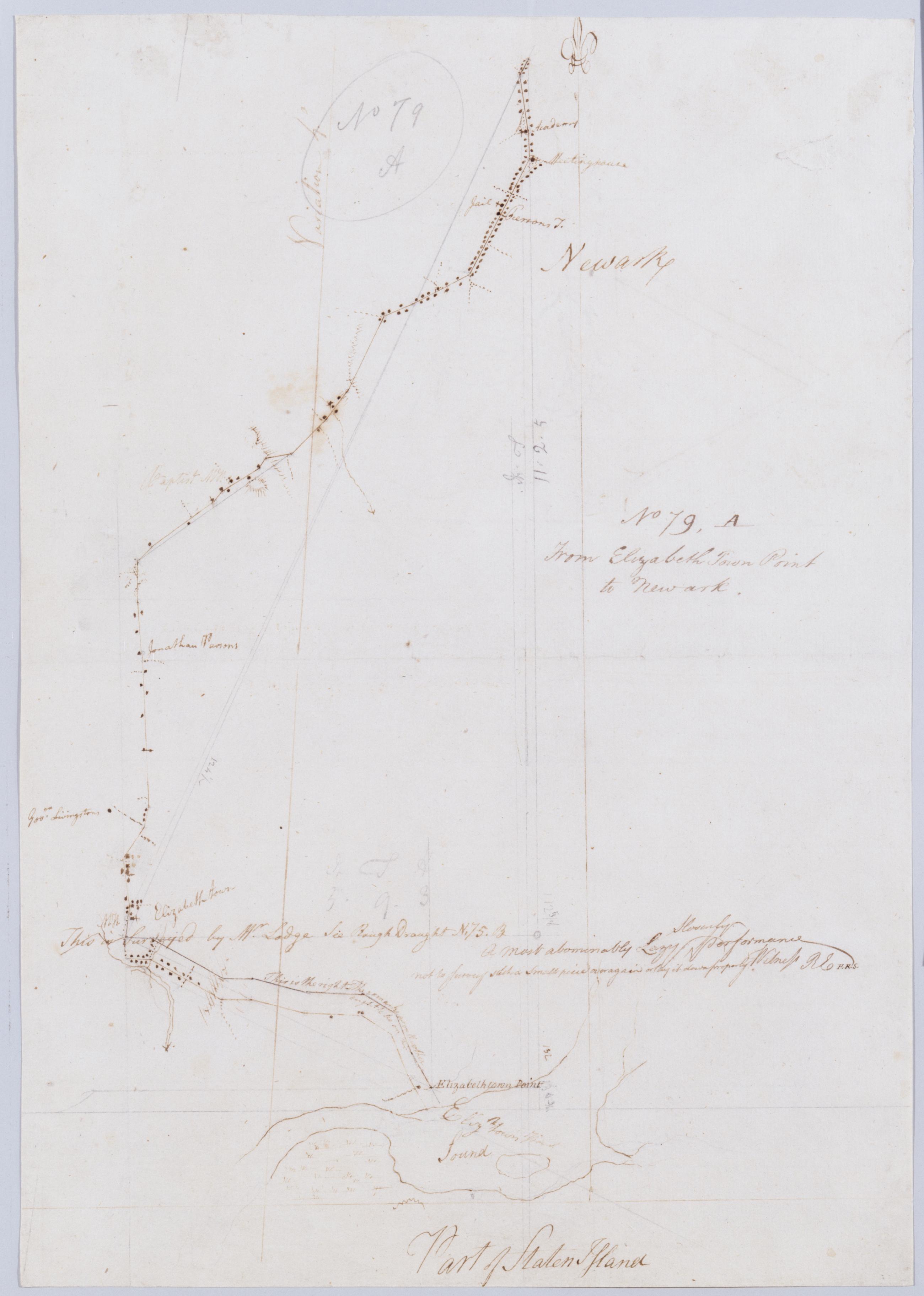
Cartographic From Elizabeth Town Point to Newark. No 79, A / by Robert Erskine F.R.S. Geogr. A. U.S. and Assistants ; this is surveyed by Mr. Lodge .... In ink on verso: "A" Numeral and title cropped off. In pencil on recto: "No 79 A". Includes annotation: "This is surveyed by Mr. Lodge See Rough Draught N.75.B A Most abominably Lazy Slovenly performance not to Survey such a Small piece over again or lay it down properly Witness RE F.R.S." Military topographic map. Covers part of Union and Essex counties in New Jersey. Shows roads running through Elizabeth and Newark. Also shows buildings and owners' names, landforms and streams. Pen-and-ink, pencil on laid paper. Shows relief by hachures. Stained, torn and abraded. View Item
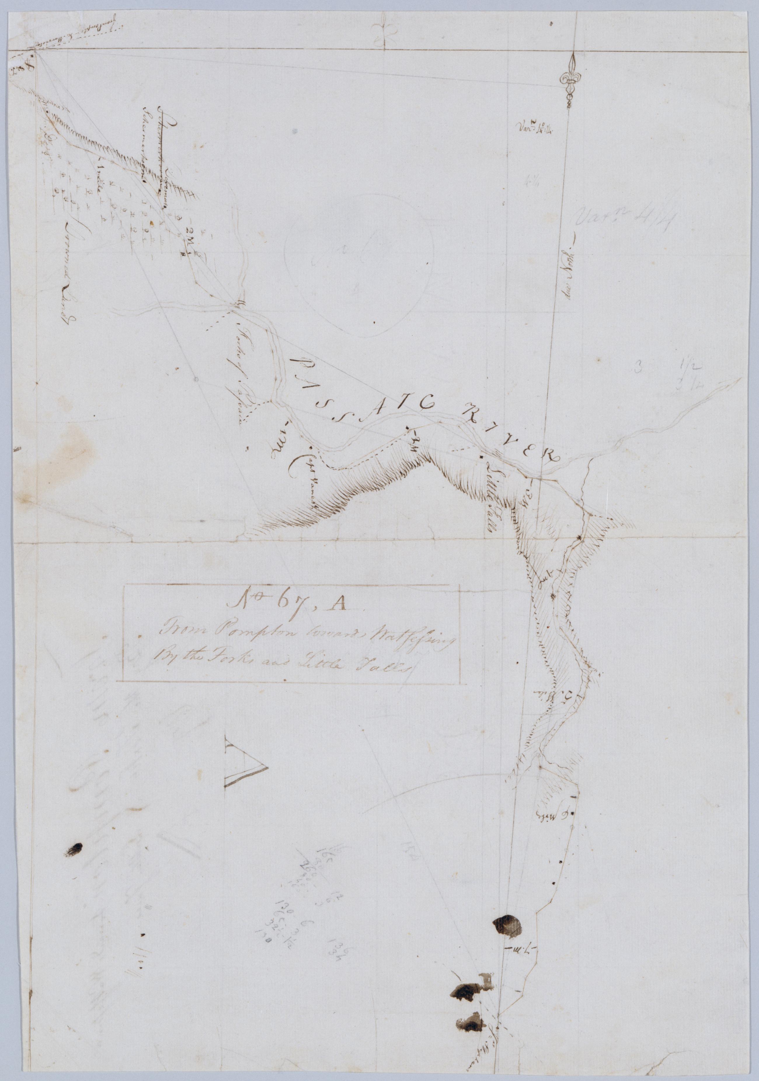
Cartographic From Pompton towards Watsessing By the Forks and Little Falls. No 67, A / by Robert Erskine F.R.S. Geogr. A. U.S. and Assistants. Also in ink on verso: "No. 67 A". In ink on recto: "A". Military topographic map. Covers the townships of Wayne and Little Falls in Passaic County and of Caldwell and Milburn in Essex County, New Jersey. Shows roads running through Two Bridges, Little Falls, Cedar Grove and Montclair. Also shows buildings and owners' names, also landforms, streams and wetlands. Pen-and-ink, pencil on laid paper. Shows relief by hachures. Stained, foxed, creased, frayed and abraded. Mounted on cloth, bound and cropped, disbound and silked by subsequent owners. View Item
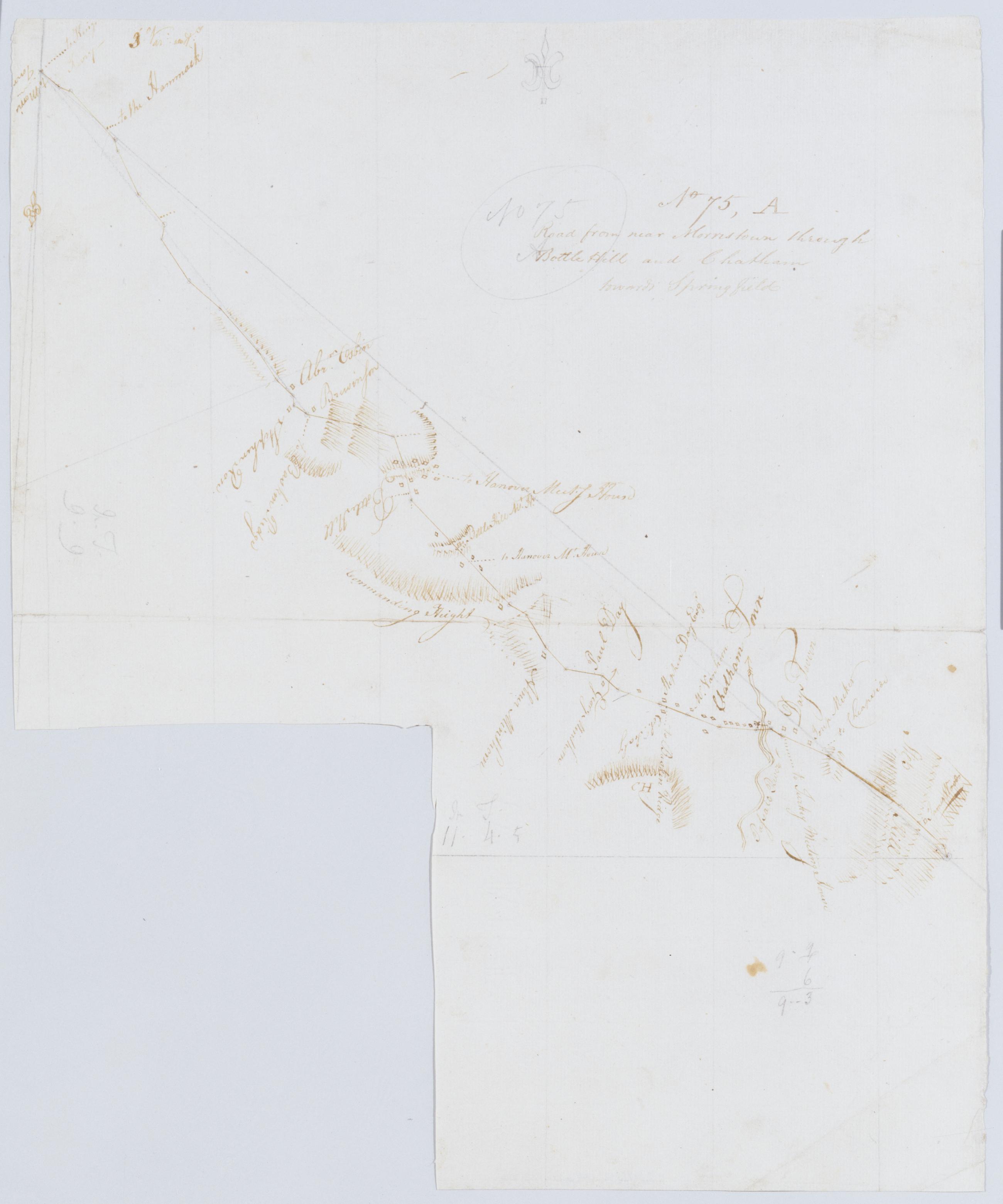
Cartographic Road from near Morristown through Bottle Hill and Chatham towards Springfield. No 75, A / by Robert Erskine F.R.S. Geogr. A. U.S. and Assistants. Fragment of original title in ink on verso: "Roa....". Imperfect: 16 x 14 cm. at lower left corner cut out after title written on verso. In pencil on recto: "No 75 A". Military topographic map. Covers the townships of Morris and Chatham in Morris County, Milburn in Essex County and Union in Summit County, New Jersey. Shows roads running through Morristown and Chatham. Also shows buildings and owners' names, landforms and streams. Pen-and-ink, pencil on laid paper. Shows relief by hachures. Stained, foxed, creased and abraded. View Item
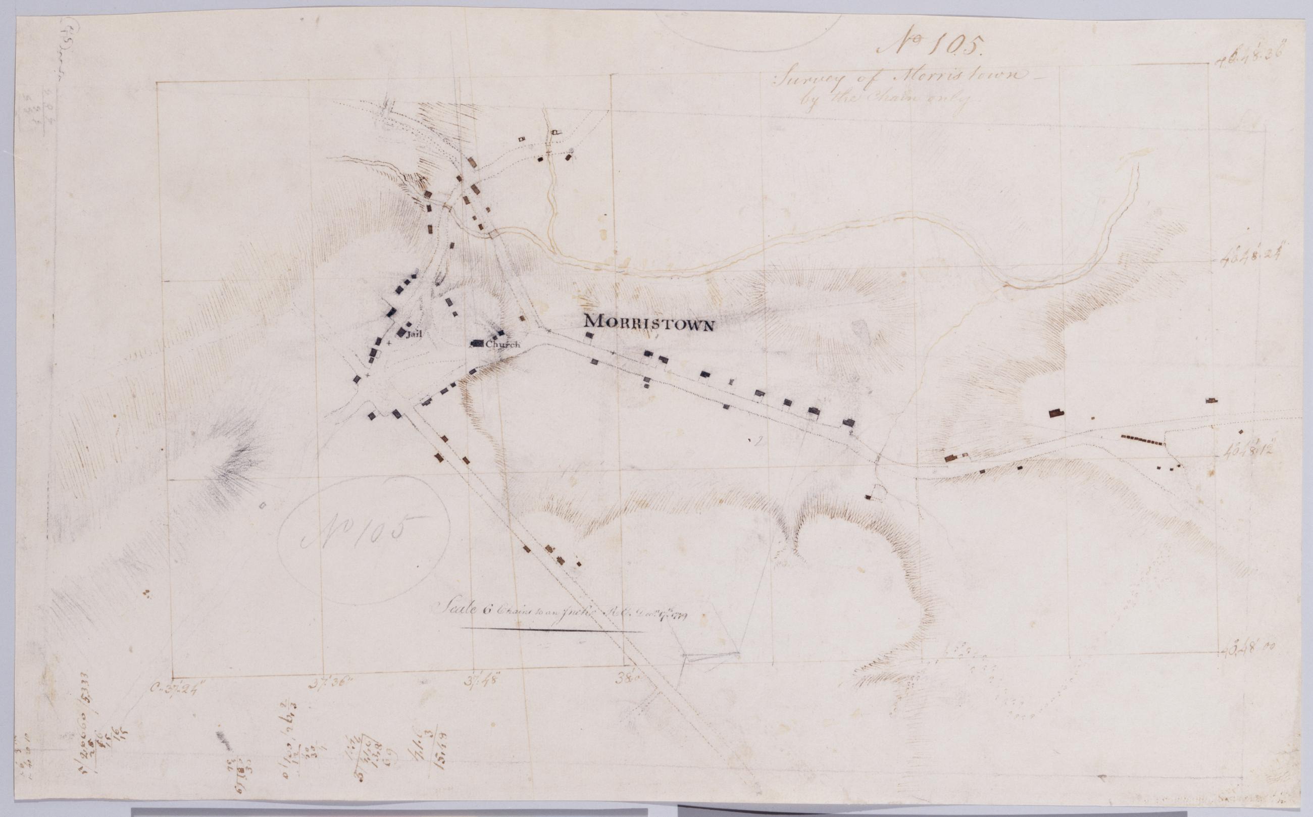
Cartographic Survey of Morristown, by the chain only. No 105 / R.E. ; by Robert Erskine F.R.S. Geogr. A. U.S. and Assistants. In pencil on recto: "No 105". Military topographic map. Covers the city of Morristown in Morris County, New Jersey. Shows buildings, landforms and streams. Pen-and-ink, pencil on laid paper. Shows relief by hachures. Stained soiled, creased and abraded. Mounted on cloth, bound and cropped, disbound and silked by subsequent owners. Cleaned after removal of backings 1999; some fill remains. Sheathed in mylar. Title proper from recto is the work of a later editor--Simeon DeWitt or his assign--subsequent to 1820. View Item
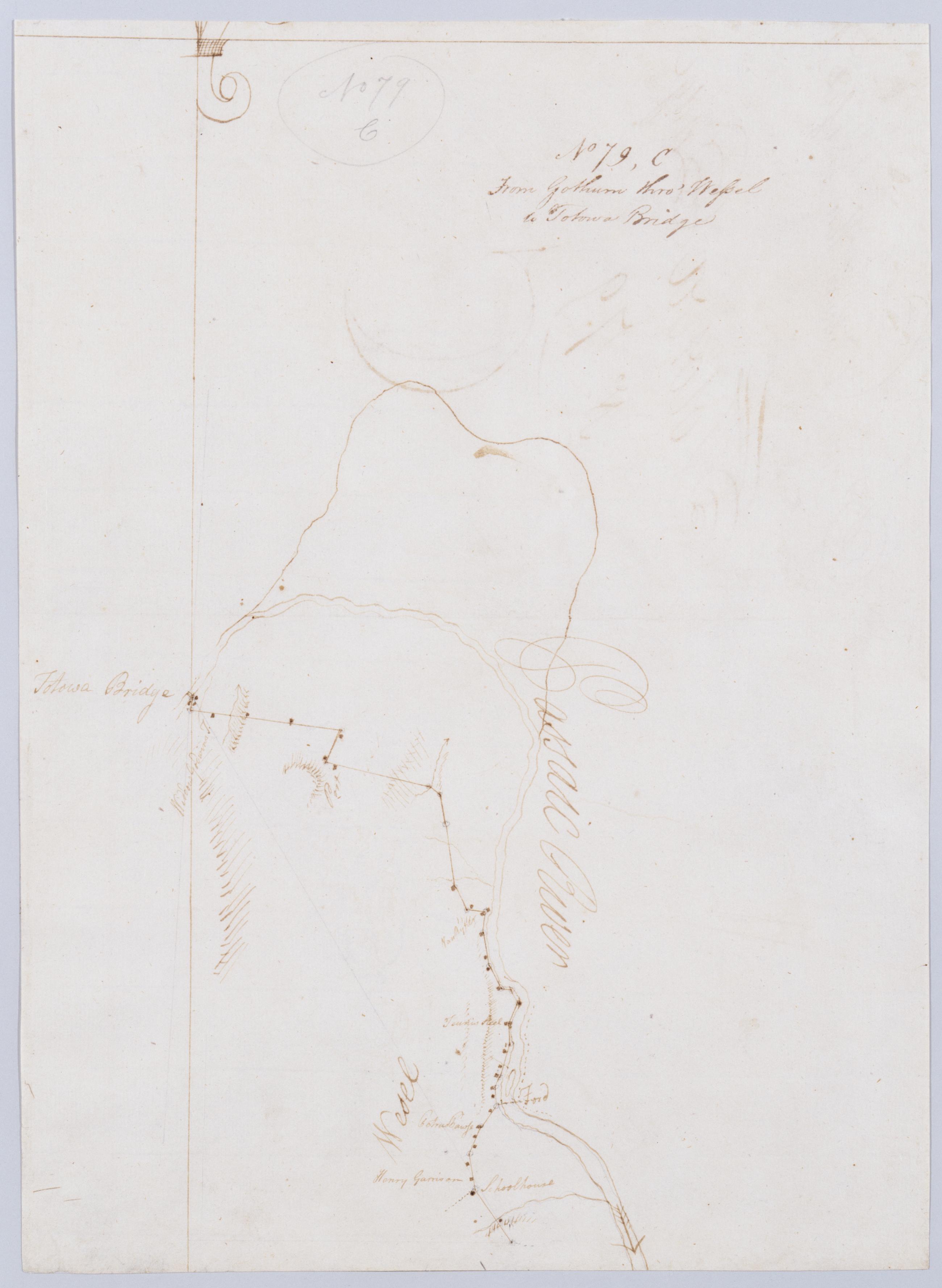
Cartographic From Gothum thro' Wessel to Totowa Bridge. No 79, C / by Robert Erskine F.R.S. Geogr. A. U.S. and Assistants ; this is Surveyd by Mr. Lodge .... In pencil on recto: "No 79 C". Military topographic map. Covers part of Passaic County, New Jersey. Shows roads running through Clifton, South Paterson and Totowa. Also shows buildings and owners' names, landforms and streams. Pen-and-ink, pencil on laid paper. Scale badly distorted. Shows relief by hachures. Soiled and abraded. Mounted on cloth, bound and cropped, disbound and silked by subsequent owners. Cleaned after removal of backings 1999; some fill remains. Sheathed in mylar. Title proper from recto is the work of a later editor--Simeon DeWitt or his assign--subsequent to 1820. View Item
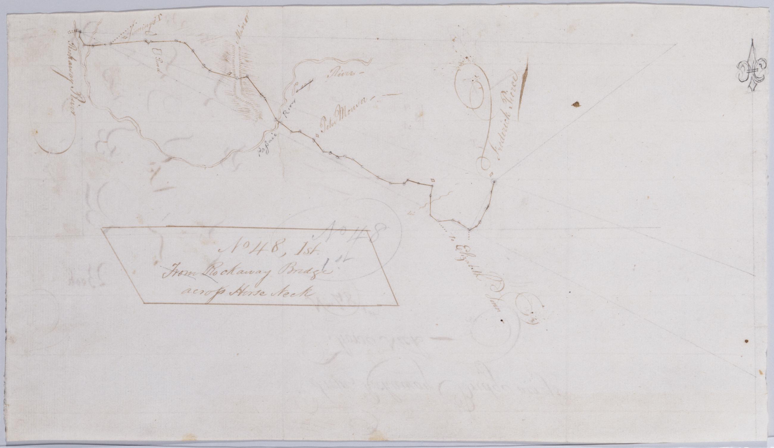
Cartographic From Rockaway Bridge across Horse Neck. No 48, 1st / by Robert Erskine F.R.S. Geogr. A. U.S. and Assistants. Foxed and abraded. Mounted on cloth, bound and cropped, disbound and silked by subsequent owners. Cleaned after removal of backings 1999; some fill remains. Sheathed in mylar. In pencil on recto: "No 48". Military topographic map. Covers the townships of Caldwell in Essex County and Montville in Morris County, New Jersey. Shows roads running across the former Horseneck Bridge and through Clinton; this area is now called Fairfield. Also shows buildings and owners' names, landforms and streams. No watermark. Pen-and-ink, pencil on laid paper. Shows relief by hachures. View Item
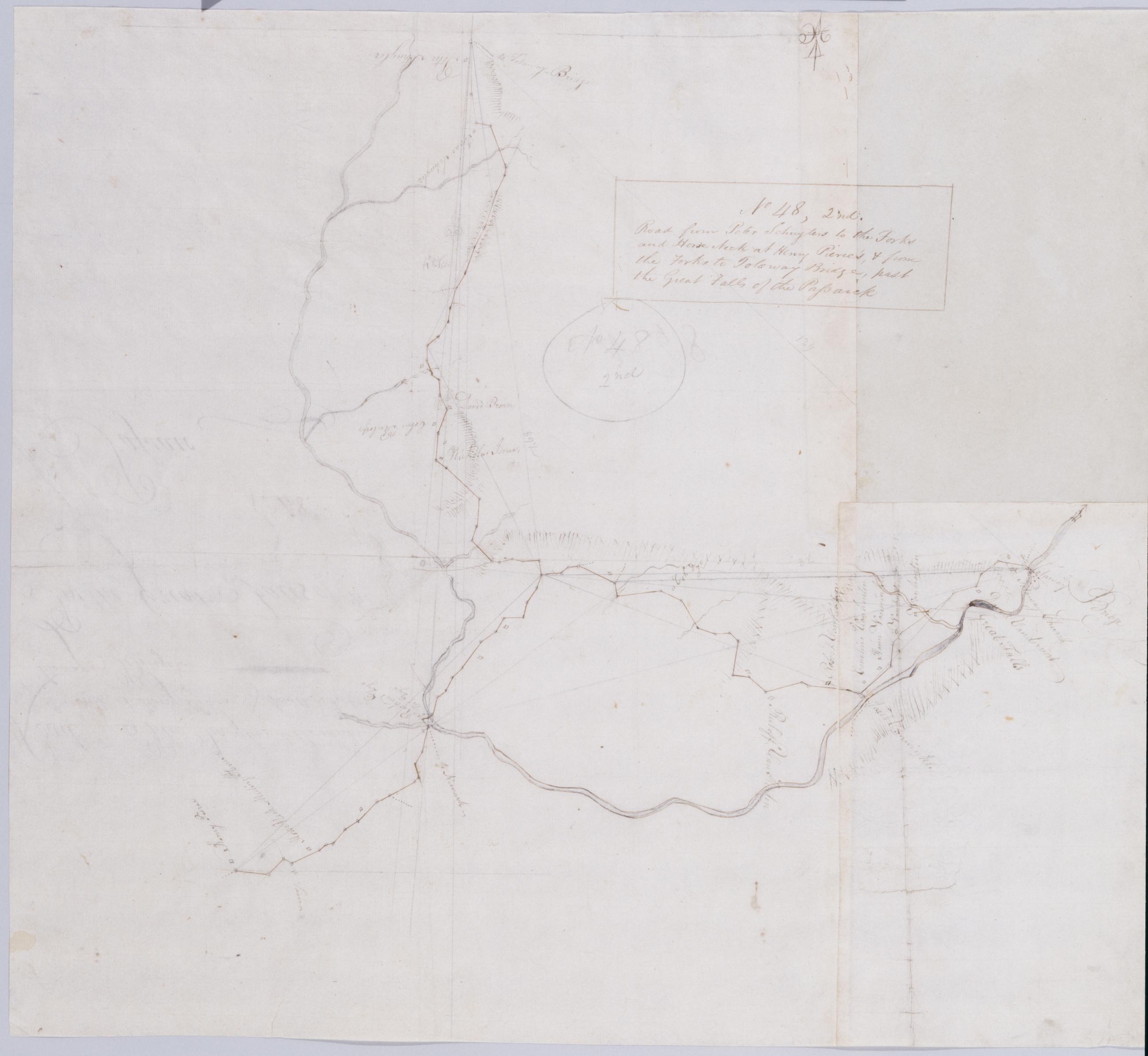
Cartographic Road from Peter Schuylers to the Forks and Horse Neck at Henry Pierce's, + from the Forks to To[t]oway Bridge, past the Great Falls of the Passaick. No 48, 2nd / by Robert Erskine F.R.S. Geogr. A. U.S. and Assistants. Also in ink on verso: "N 48". In pencil on recto: "No 48 2nd". Military topographic map. Covers the townships of Little Falls, Manchester and Wayne in Passaic County and of Pequannac in Morris County, New Jersey. Shows roads running through Pompton Plains, Wayne, Mountain View, Two Bridges, Fairfield, Clinton and Totowa. Also shows buildings and owners' names, landforms and streams. Pen-and-ink, pencil on two pieces laid paper and one piece wove paper. Shows relief by hachures. Stained, creased, foxed and abraded. Razor cuts and pinpricks for copying. View Item
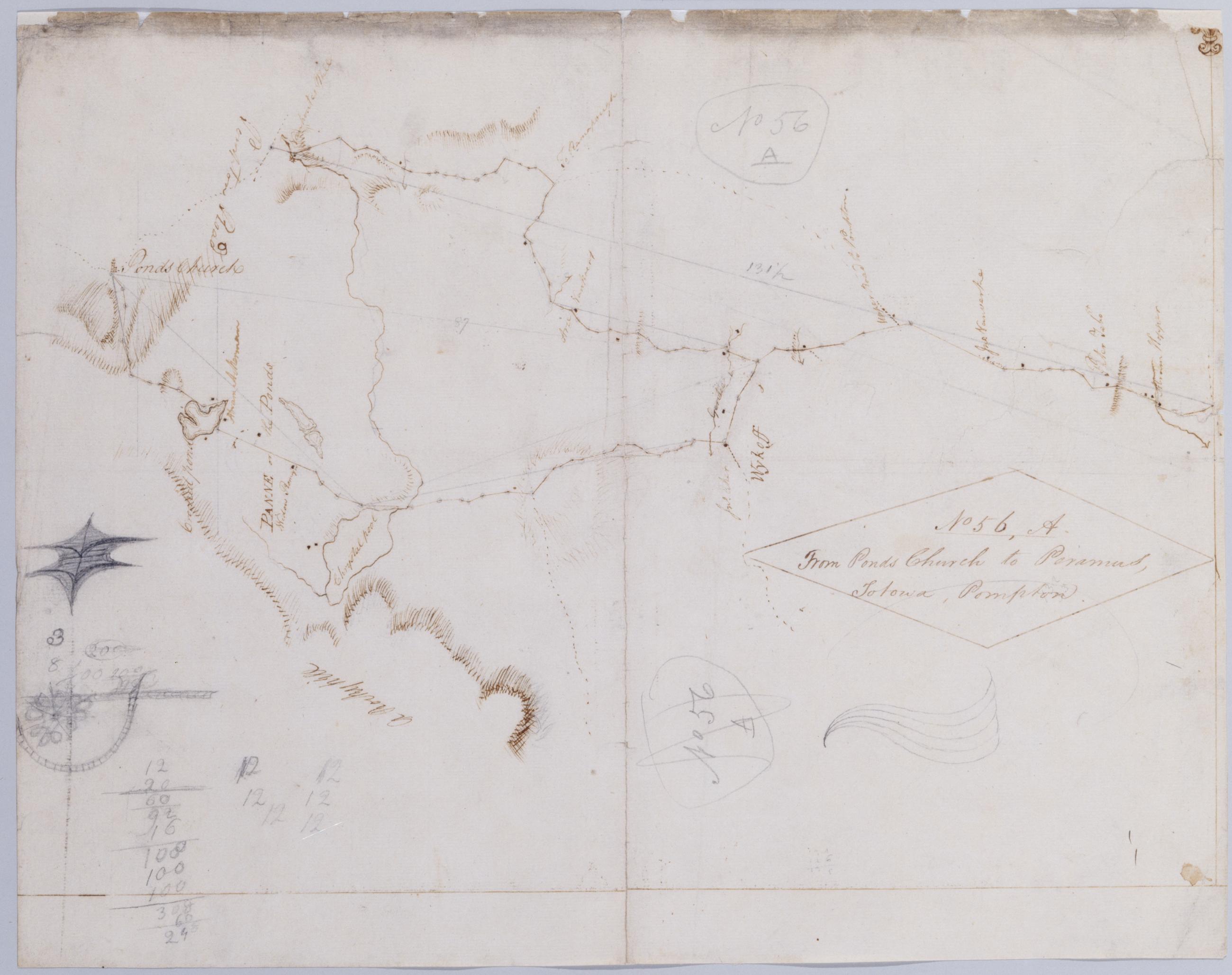
Cartographic From Ponds Church to Paramus, Totowa, Pompton. No 56, A / by Robert Erskine F.R.S. Geogr. A. U.S. and Assistants. In pencil on recto: "No 56 A". Military topographic map. Covers the township of Franklin in Bergen County, New Jersey; "Chrystal pool" is now called Franklin Lake. Shows roads running through Pompton Lakes, Pompton, Oakland, Camp Gaw, Wykoff and Waldwick. Also shows buildings and owners' names, landforms and streams. Pen-and-ink, pencil on laid paper. Shows relief by hachures. Title proper from recto is the work of a later editor--Simeon DeWitt or his assign--subsequent to 1820. Title from verso is in Erskine's hand and may be cited as such. View Item
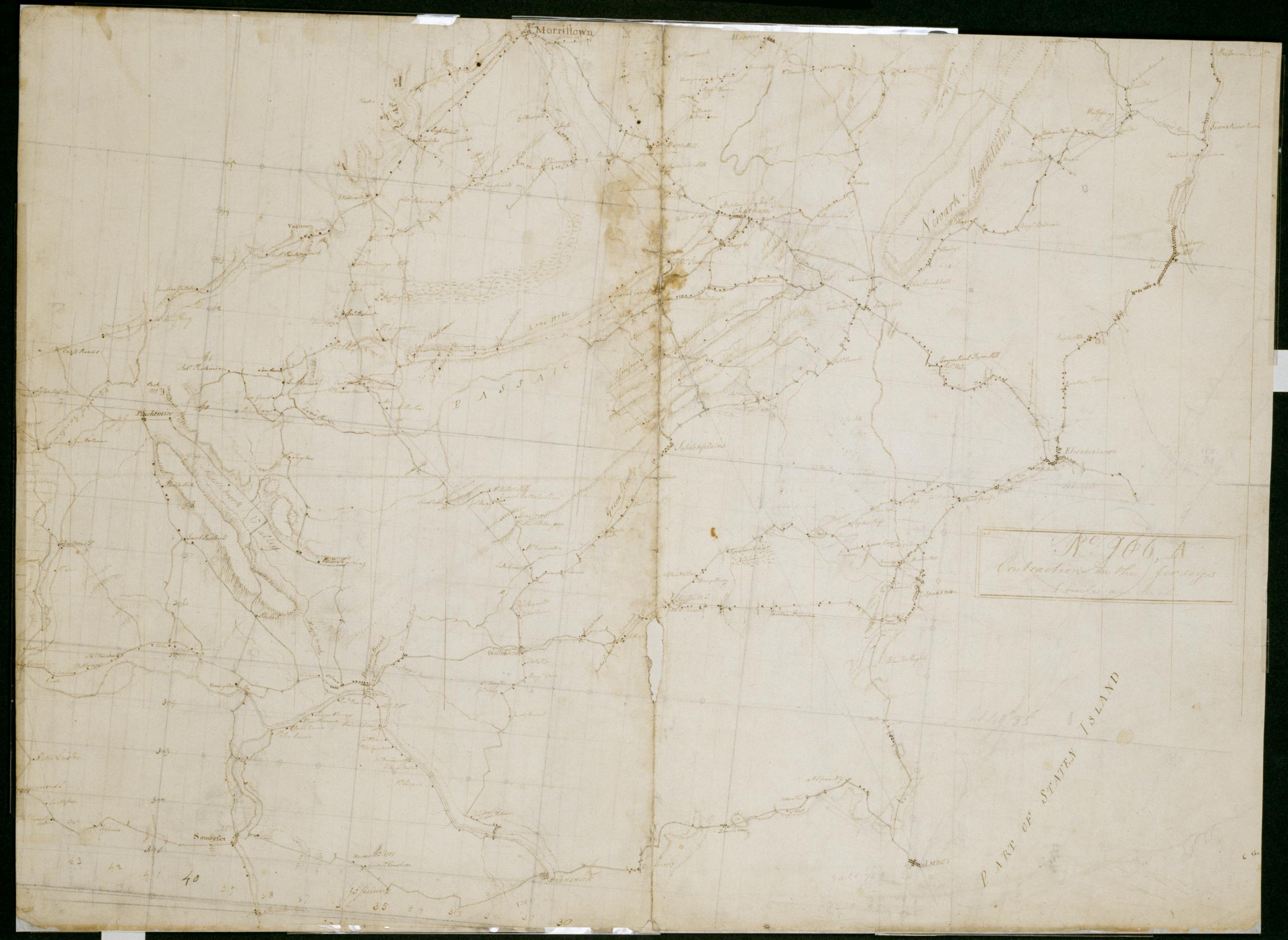
Cartographic Contraction in the Jerseys 1 mile an Inch. No. 106, A / by S. DeWitt A.B. ; by Robert Erskine F.R.S. Geogr. A. U.S. and Assistants. Imperfect: lacking 6 x 1 cm. at lower center of sheet. In ink on verso "No- 106- A". In pencil on recto: "No 106 A". Military topographic map. Covers the counties of Middlesex, Union, Essex, Somerset and Morris in New Jersey. Shows buildings and owners' names, landforms and streams. Pen-and-ink, pencil on laid paper. Shows relief by hachures. Stained, creased, frayed and abraded. Mounted on cloth, bound and cropped, disbound and silked by subsequent owners. Cleaned after removal of backings 1999; re-backed with China paper. Sheathed in mylar. View Item
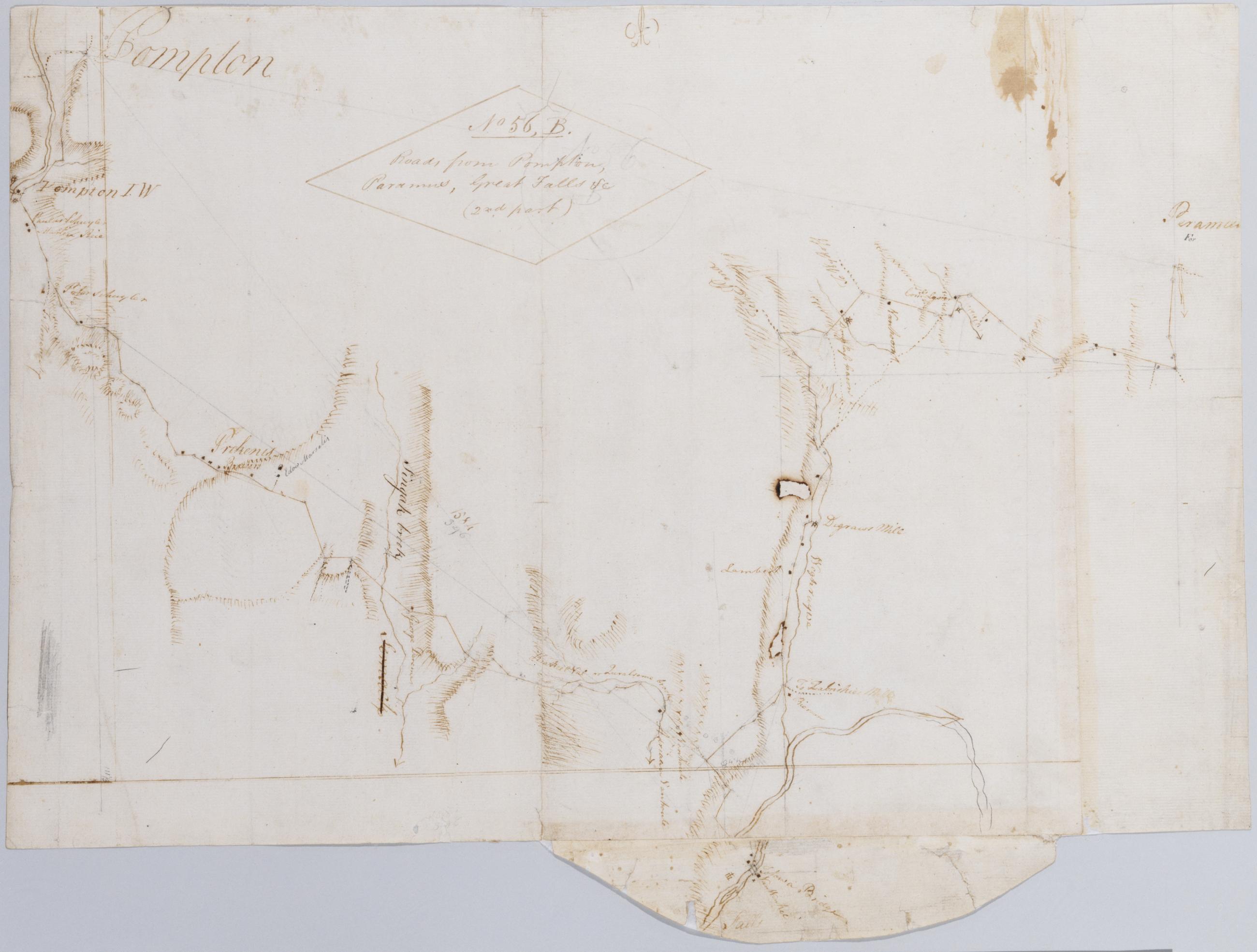
Cartographic Roads from Pompton, Paramus, Great Falls +c (2nd part) No 56, B / by Robert Erskine F.R.S. Geogr. A. U.S. and Assistants. In ink on verso: "No. 56 B-". In pencil on recto: "No 56 B". Military topographic map. Covers the townships of Wayne, Manchester, Ridgewood and Saddle River in Passaic County, New Jersey. Shows roads running through Pompton, Haledon, Goffle, Van Windle, Midland Park, Ridgewood and Paramus. Also shows buildings and owners' names, landforms and streams. Pen-and-ink, pencil on laid paper. Shows relief by hachures. Title proper from recto is the work of a later editor--Simeon DeWitt or his assign--subsequent to 1820. View Item
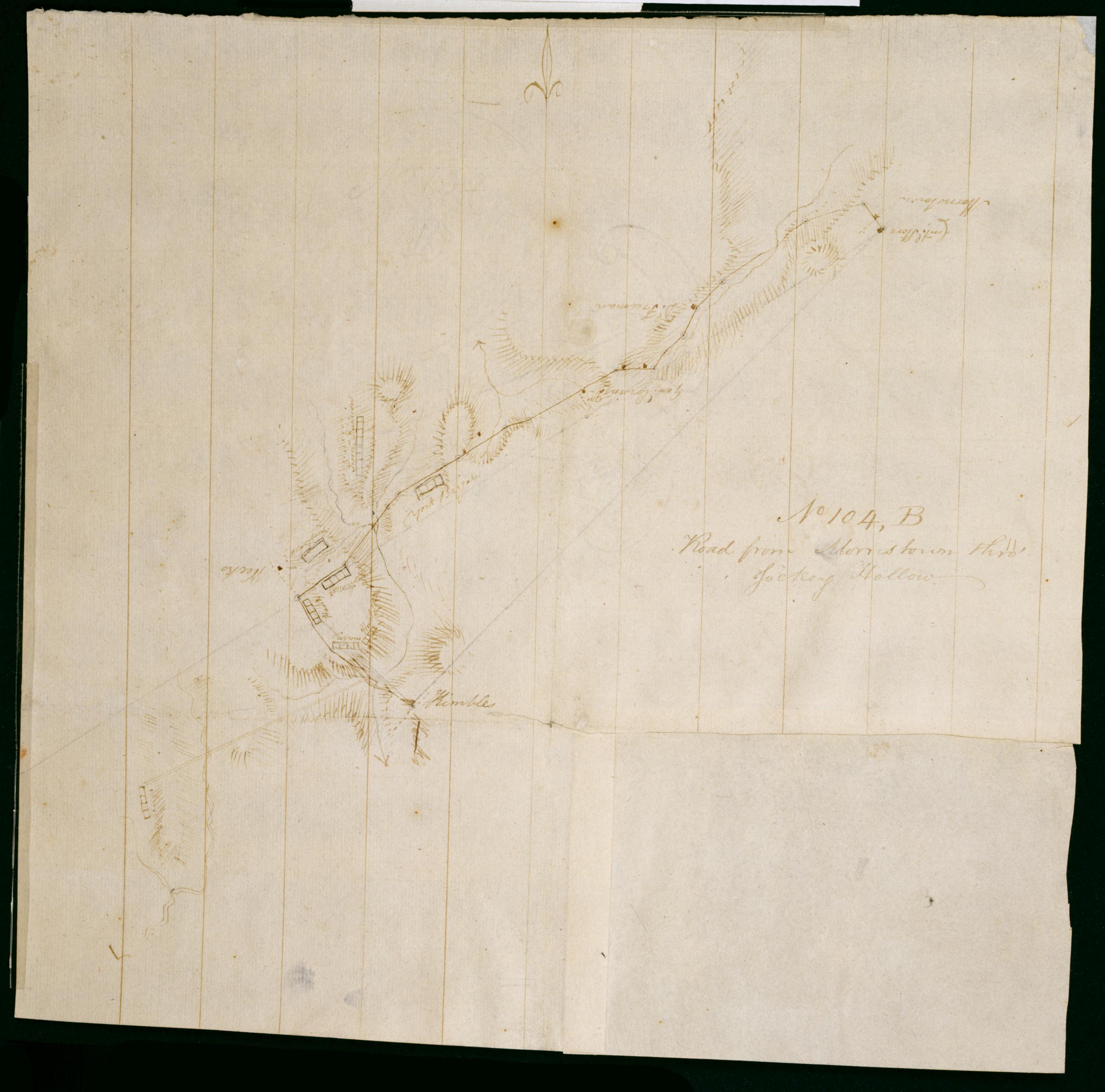
Cartographic Road from Morristown thro' Jockey Hollow. No 104, B / by Robert Erskine F.R.S. Geogr. A. U.S. and Assistants. Foxed, creased, frayed and abraded. Mounted on cloth, bound and cropped, disbound and silked by subsequent owners. Cleaned after removal of backings 1999; some fill remains. Sheathed in mylar. In erased pencil on recto: "No 104 B". Military topographic map. Covers the townships of Passaic and Morris in Morris County and of Bernard in Somerset County, New Jersey. Marks and lables troop positions at Morristown. Also shows roads, buildings and owners' names, landforms and streams. Pen-and-ink, pencil on laid paper. Patch at right corner is later, wove finish paper. Shows relief by hachures. View Item
Cartographic Road from near Genl Wines to Morristown and from sd road to Boonton thence down the Rockaway River until it joins a road surveyd by Mr Lodge. No 90. B / by Robert Erskine F.R.S. Geogr. A. U.S. and Assistants. In pencil on recto: "No 90 B". Military topographic map. Covers the townships of Randolph, Hanover, Morris and Boonton in Morris County, New Jersey. Shows roads running through Dover, Franklin, Morristown, Littleton, Boonton and Montville. Also shows buildings and owners' names, landforms and streams. Pen-and-ink, pencil on laid paper. Shows relief by hachures. Stained, soiled, creased and abraded. Mounted on cloth, bound, disbound and silked by subsequent owners. Cleaned after removal of backings 1999; some fill remains. Sheathed in mylar. View Item
Cartographic Road from the Sussex Road towards Morris Town past Longwood, Burkshire Beaman's and Mt Pleasant Forges to Genl Wynes's. No 90, C / by Robert Erskine F.R.S. Geogr. A. U.S. and Assistants. In pencil on recto: "No 90 C". Military topographic map in three segments meant to meet at points marked "A" and "B." Map covers the townships of Hardiston, Jefferson, Rockaway and Vernon in Morris County, New Jersey. Shows roads running through Vernon, Williams Mine, Stockholm, Milton, Berkshire Valley, Spicertown and Dover. Also shows buildings and owners' names, landforms and streams. Pen-and-ink, pencil on laid paper. Shows relief by hachures. Stained, foxed, creased and abraded. Mounted on cloth, bound, disbound and silked by subsequent owners. View Item
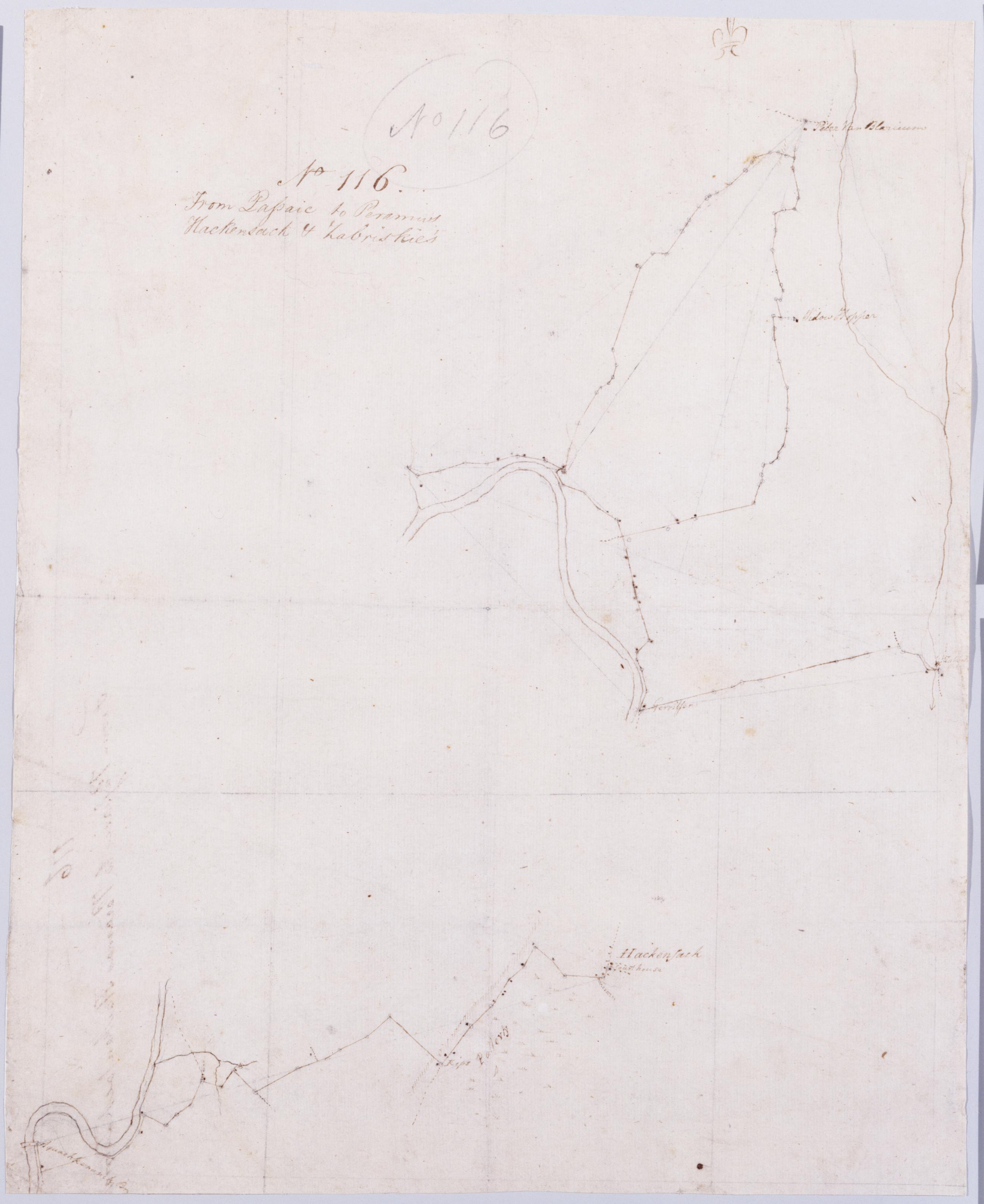
Cartographic From Passaic to Peramus Hackensack + Zabriskie's. No 116 / by Robert Erskine F.R.S. Geogr. A. U.S. and Assistants. Foxed, creased, soiled and abraded. Mounted on cloth, bound and cropped, disbound and silked by subsequent owners. Cleaned after removal of backings 1999; some fill remains. Sheathed in mylar. In pencil on recto: "No 116". Military topographic maps. Upper map covers the townships of Ridgewood and Saddle River in Bergen County, New Jersey, and shows roads running through Fernside, Glen Rock, Ridgewood, Paramus, Arcola, Warren Point and Fairlawn. Lower map covers the townships of Lodi and Saddle River, also in Bergen County, and shows roads running through Garfield. View Item
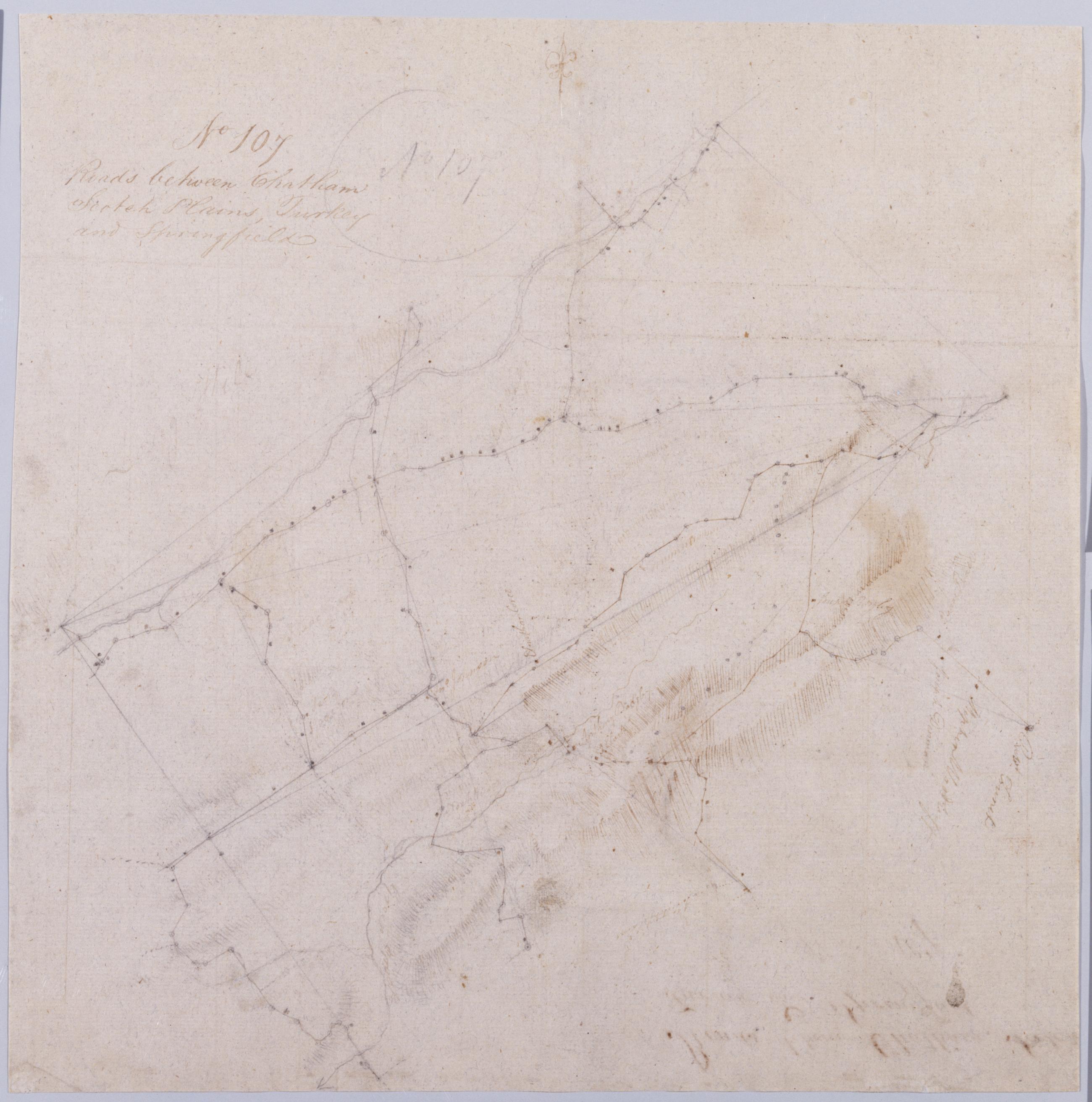
Cartographic Roads between Chatham Scotch Plains, Turkey and Springfield. No 107 / by Robert Erskine F.R.S. Geogr. A. U.S. and Assistants. In pencil on recto: "No 107". Military topographic map. Covers the townships of Summit, Springfield, Providence, Westfield, Fanwood and North Plainfield in Union County, New Jersey. Shows buildings and owners' names, landforms and streams. Pen-and-ink, pencil on laid paper. Title proper from recto is the work of a later editor--Simeon DeWitt or his assign--subsequent to 1820. Title from verso is in Erskine's hand and may be cited as such. Index title, statement of responsibility, date, series title and series numbering also by Erskine, but on separate index sheet filed at head of series. View Item
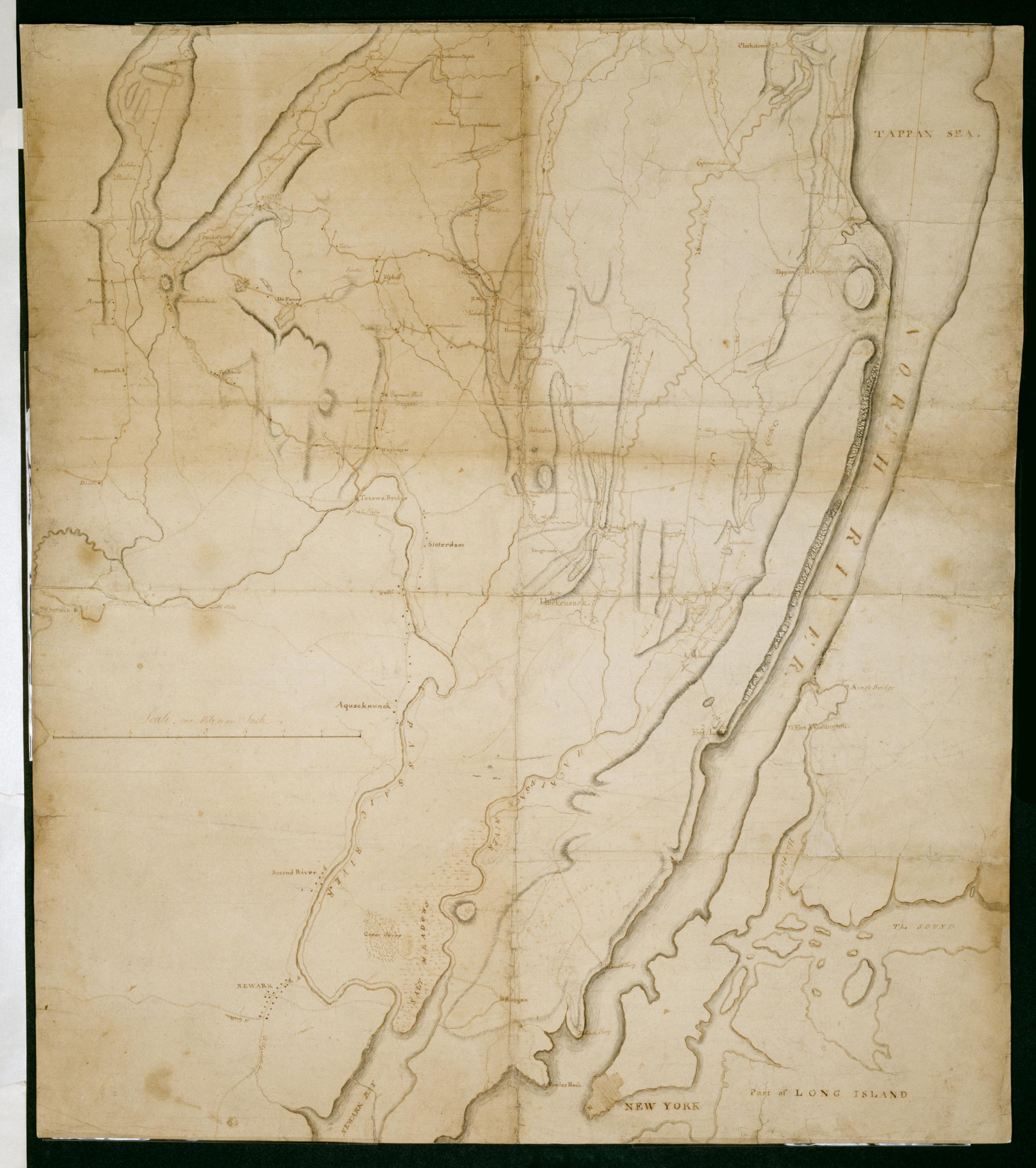
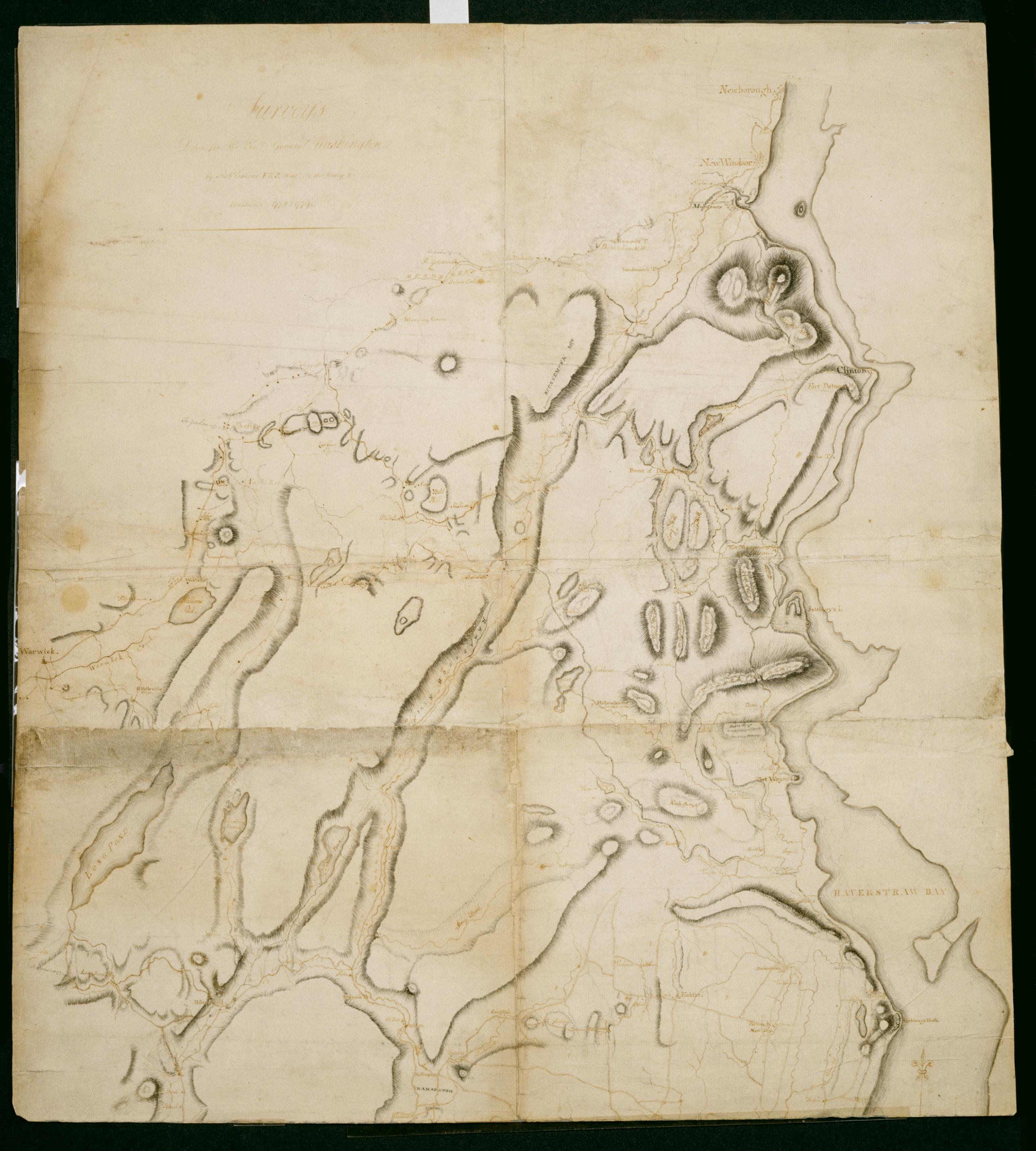
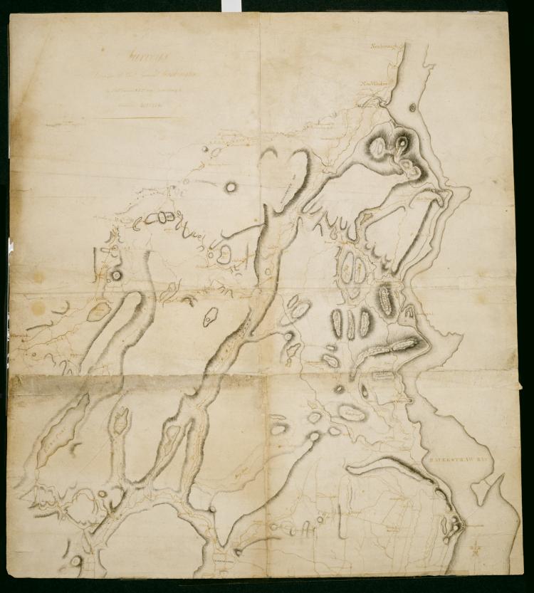
Cartographic Surveys Done for His Excy General Washington : 1778 & 1779 / by Robt Erskine F.R.S. Geogr to the Army & Assistants, second sheet Verso title: Map of North River made by Robt Erskine 1778 & 9. Second verso title: Map of part of the State of New York. Military topographic map; not listed in Heusser nor Guthorn. Covers the counties of Orange and Rockland in New York and of Passaic, Bergen, Hudson and Essex in New Jersey. Shows some roads; map appears to be incomplete in this respect as of date given. Also shows some buildings and owners' names, landforms and streams. Shows relief by hachures. Title proper and statement of responsibility from recto is original. Titles on verso are later. View Item
Cartographic Surveys Done for His Excy General Washington : 1778 & 1779 / by Robt Erskine F.R.S. Geogr to the Army & Assistants, first sheet Verso title: Map of North River made by Robt Erskine 1778 & 9. Second verso title: Map of part of the State of New York. Military topographic map; not listed in Heusser nor Guthorn. Covers the counties of Orange and Rockland in New York and of Passaic, Bergen, Hudson and Essex in New Jersey. Shows some roads; map appears to be incomplete in this respect as of date given. Also shows some buildings and owners' names, landforms and streams. Shows relief by hachures. Title proper and statement of responsibility from recto is original. Titles on verso are later. View Item
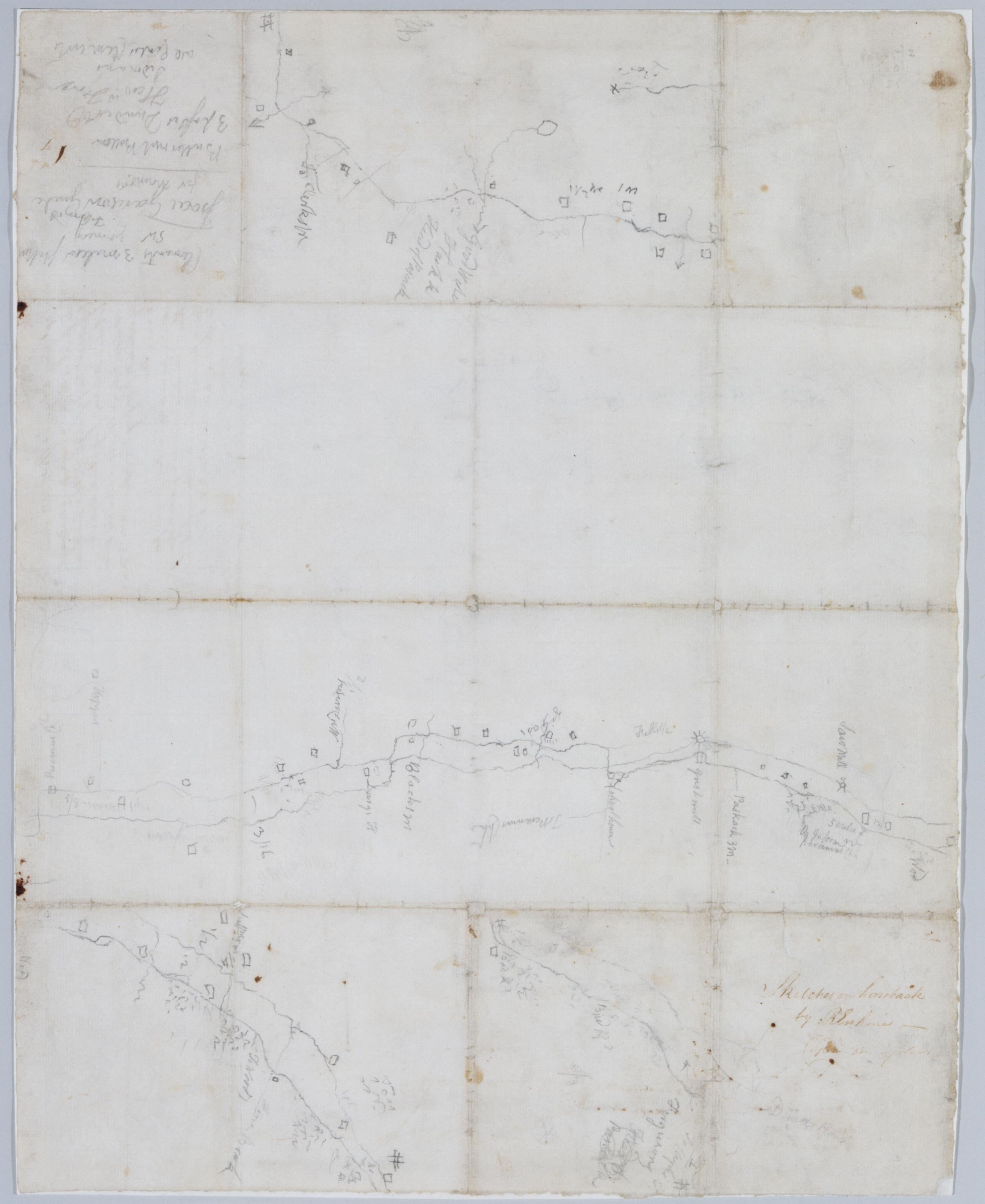
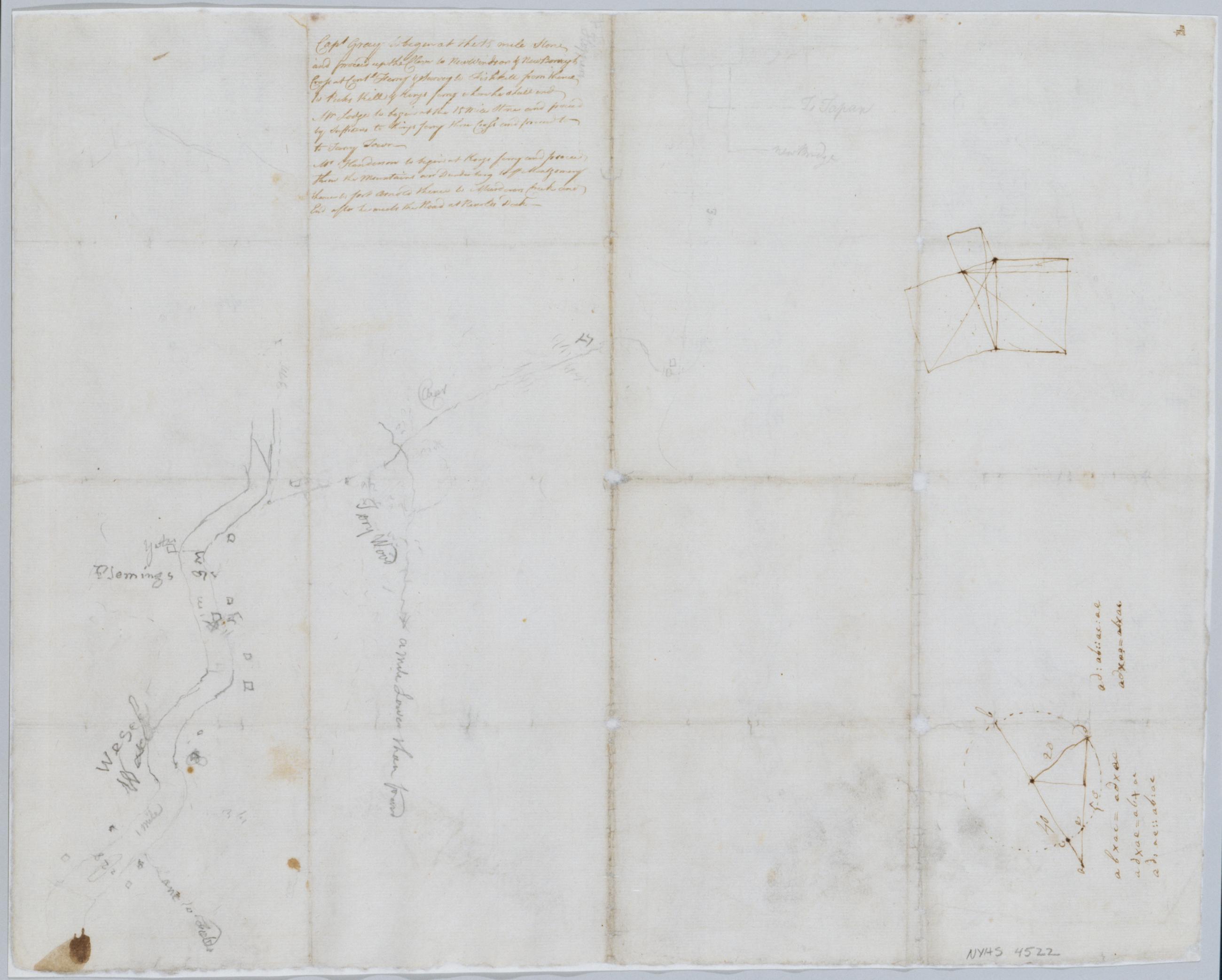
Cartographic Sketches on horseback / by R Erskine cop[ied] on plans, recto Date based on comparison with Erskine's "Surveys Done for His Excy General Washington 1778 & 1779." Foxed, creased and abraded. Cleaned after removal of backings 1999; some fill remains. Sheathed in mylar. Includes unrelated text in ink on verso: "Capt Gray to begin at the 15 mile Stone and proceed up the Clove to New Windsor & New Borough Cross at Contl Ferry & Survey to Fishkill from thence to Peeks Kill & Kings ferry where he shall end. Mr Lodge to begin at the 15 Mile Stone and proceed by Suffrans to Kings ferry there Cross and proceed to to [sic] Tarry Town. View Item
Cartographic Sketches on horseback / by R Erskine cop[ied] on plans, verso Date based on comparison with Erskine's "Surveys Done for His Excy General Washington 1778 & 1779." Foxed, creased and abraded. Cleaned after removal of backings 1999; some fill remains. Sheathed in mylar. Includes unrelated text in ink on verso: "Capt Gray to begin at the 15 mile Stone and proceed up the Clove to New Windsor & New Borough Cross at Contl Ferry & Survey to Fishkill from thence to Peeks Kill & Kings ferry where he shall end. Mr Lodge to begin at the 15 Mile Stone and proceed by Suffrans to Kings ferry there Cross and proceed to to [sic] Tarry Town. View Item
Image Cartographic 2 Items Surveys Done for His Excy General Washington : 1778 & 1779 / by Robt Erskine F.R.S. Geogr to the Army & Assistants Military topographic map; not listed in Heusser nor Guthorn. Covers the counties of Orange and Rockland in New York and of Passaic, Bergen, Hudson and Essex in New Jersey. Shows some roads; map appears to be incomplete in this respect as of date given. Also shows some buildings and owners' names, landforms and streams. Shows relief by hachures. Title proper and statement of responsibility from recto is original. Titles on verso are later. Date by cataloger, based on comparison to Erskine's dated sketch, "Mensurations on the Ice". Pen-and-ink, pencil on laid paper. View Item
Image Cartographic 2 Items Sketches on horseback / by R Erskine cop[ied] on plans. Date based on comparison with Erskine's "Surveys Done for His Excy General Washington 1778 & 1779." Foxed, creased and abraded. Cleaned after removal of backings 1999; some fill remains. Sheathed in mylar. Includes unrelated text in ink on verso: "Capt Gray to begin at the 15 mile Stone and proceed up the Clove to New Windsor & New Borough Cross at Contl Ferry & Survey to Fishkill from thence to Peeks Kill & Kings ferry where he shall end. Mr Lodge to begin at the 15 Mile Stone and proceed by Suffrans to Kings ferry there Cross and proceed to to [sic] Tarry Town. View Item
Cartographic Road from Kembles to Chatham. No 104 A / by Robert Erskine F.R.S. Geogr. A. U.S. and Assistants. Foxed- creased- frayed and abraded. Mounted on cloth- bound and cropped- disbound and silked by subsequent owners. Cleaned after removal of backings 1999; some fill remains. Sheathed in mylar. In pencil on recto: "No 104 A". Military topographic map. Covers the townships of Passaic and Morris in Morris County and of Bernard in Somerset County- New Jersey. Shows roads running through Chatham- Morristown- Logansville- Millington and Liberty Corner. Also shows buildings and owners' names- landforms and streams. Pen-and-ink- pencil on laid paper. Shows relief by hachures. View Item
Cartographic From Newark thro' Aquacknonk to Gothum. No 79 B / by Robert Erskine F.R.S. Geogr. A. U.S. and Assistants ; this is Surveyd by Mr. Lodge .... In pencil on recto: "No 79 B". Military topographic map. Covers part of Passaic and Essex counties in New Jersey. Shows roads running through Newark- Belleville and Clifton. Also shows buildings and owners' names- landforms and streams. Pen-and-ink- pencil on laid paper. Shows relief by hachures. Stained- torn and abraded. Mounted on cloth- bound and cropped- disbound and silked by subsequent owners. Cleaned after removal of backings 1999; some fill remains. Sheathed in mylar. Title proper from recto is the work of a later editor--Simeon DeWitt or his assign--subsequent to 1820. View Item
Cartographic Road from Pompton by the Warwick Road to Morristown up Pompton River Past Charlotteburgh Iron Works No 90 A / by Robert Erskine F.R.S. Geogr. A. U.S. and Assistants. Foxed- soiled- creased and abraded. Mounted on cloth- bound and cropped- disbound and silked by subsequent owners. Cleaned after removal of backings 1999; some fill remains. Sheathed in mylar. In pencil on recto: "No 90 ..." (erased). Military topographic map. Covers the townships of West Milford and Pompton in Passaic County and of Rockaway and Pequanac in Morris County- New Jersey. Shows roads running though Oak Ridge- Newfoundland- Smith Mills and Bloomingdale. Also shows buildings and owners' names- landforms and streams. Pen-and-ink- pencil on laid paper. Shows relief by hachures. View Item
Cartographic From Elizabeth Town Point to Newark. No 79 A / by Robert Erskine F.R.S. Geogr. A. U.S. and Assistants ; this is surveyed by Mr. Lodge .... In ink on verso: "A" Numeral and title cropped off. In pencil on recto: "No 79 A". Includes annotation: "This is surveyed by Mr. Lodge See Rough Draught N.75.B A Most abominably Lazy Slovenly performance not to Survey such a Small piece over again or lay it down properly Witness RE F.R.S." Military topographic map. Covers part of Union and Essex counties in New Jersey. Shows roads running through Elizabeth and Newark. Also shows buildings and owners' names- landforms and streams. Pen-and-ink- pencil on laid paper. Shows relief by hachures. Stained- torn and abraded. View Item
Cartographic From Pompton towards Watsessing By the Forks and Little Falls. No 67 A / by Robert Erskine F.R.S. Geogr. A. U.S. and Assistants. Also in ink on verso: "No. 67 A". In ink on recto: "A". Military topographic map. Covers the townships of Wayne and Little Falls in Passaic County and of Caldwell and Milburn in Essex County- New Jersey. Shows roads running through Two Bridges- Little Falls- Cedar Grove and Montclair. Also shows buildings and owners' names- also landforms- streams and wetlands. Pen-and-ink- pencil on laid paper. Shows relief by hachures. Stained- foxed- creased- frayed and abraded. Mounted on cloth- bound and cropped- disbound and silked by subsequent owners. View Item
Cartographic Road from near Morristown through Bottle Hill and Chatham towards Springfield. No 75 A / by Robert Erskine F.R.S. Geogr. A. U.S. and Assistants. Fragment of original title in ink on verso: "Roa....". Imperfect: 16 x 14 cm. at lower left corner cut out after title written on verso. In pencil on recto: "No 75 A". Military topographic map. Covers the townships of Morris and Chatham in Morris County- Milburn in Essex County and Union in Summit County- New Jersey. Shows roads running through Morristown and Chatham. Also shows buildings and owners' names- landforms and streams. Pen-and-ink- pencil on laid paper. Shows relief by hachures. Stained- foxed- creased and abraded. View Item