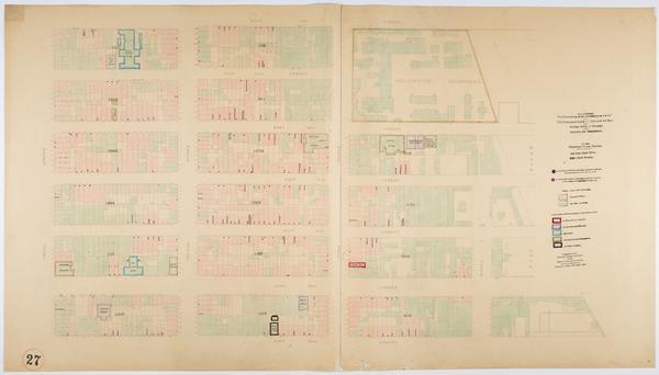
Still Image Map showing over-crowding of the buildings on the lots and the consequent lack of light and air space also strong-holds of poverty and agencies for betterment in the tenement house district bounded by 3rd Ave., East River, 28th, 22nd Streets / prepared fo Scale [ca. 1:650]. View Item
Still Image Map showing over-crowding of the buildings on the lots and the consequent lack of light and air space also strong-holds of poverty and agencies for betterment in the tenement house district bounded by 5th Street, East Houston Street, Bowery, Avenue B / pr Scale [ca. 1:650]. View Item
Still Image Map showing over-crowding of the buildings on the lots and the consequent lack of light and air space also strong-holds of poverty and agencies for betterment in the tenement house district bounded by West 12th & Bank Streets, W. 10th Street, West Street, Scale [ca. 1:650]. View Item
Still Image Map showing over-crowding of the buildings on the lots and the consequent lack of light and air space also strong-holds of poverty and agencies for betterment in the tenement house district bounded by 5th Street, East Houston Street, Avenue B, East River Scale [ca. 1:650]. View Item
Still Image Map showing over-crowding of the buildings on the lots and the consequent lack of light and air space also strong-holds of poverty and agencies for betterment in the tenement house district bounded by Division Street, East River, Rutgers, Corlears Street Scale [ca. 1:650]. View Item
Still Image Map showing over-crowding of the buildings on the lots and the consequent lack of light and air space also strong-holds of poverty and agencies for betterment in the tenement house district bounded by 12th & 13th Ave., 7th Avenue, 52nd, 46th Streets / pre Scale [ca. 1:650]. View Item
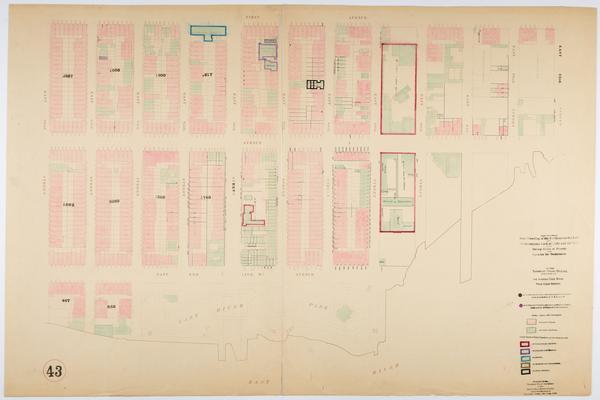
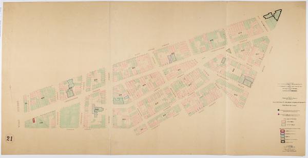
Still Image Map showing over-crowding of the buildings on the lots and the consequent lack of light and air space also strong-holds of poverty and agencies for betterment in the tenement house district bounded by 1st Avenue, East River, 93rd, 82nd Streets / prepared Scale [ca. 1:650]. Oriented with north to upper right of sheet. View Item
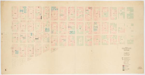
Still Image Map showing over-crowding of the buildings on the lots and the consequent lack of light and air space also strong-holds of poverty and agencies for betterment in the tenement house district bounded by Division, Rivington Streets, Essex Street, East River Scale [ca. 1:650]. Oriented with north to the upper right of sheet. View Item
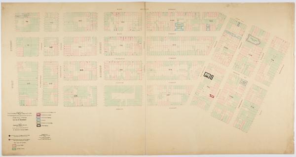
Still Image Map showing over-crowding of the buildings on the lots and the consequent lack of light and air space also strong-holds of poverty and agencies for betterment in the tenement house district bounded by West 10th Street, W. 4th, Jones, Commerce & Barrow Str Scale [ca. 1:650]. View Item
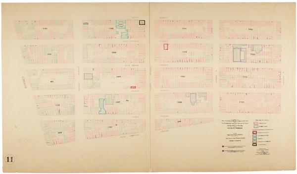
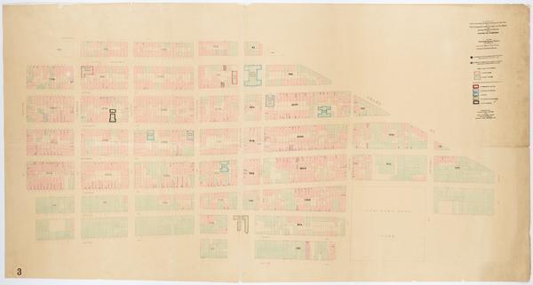
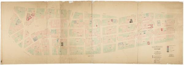
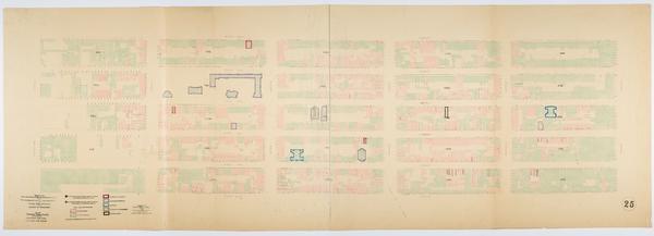
Still Image Map showing over-crowding of the buildings on the lots and the consequent lack of light and air space also strong-holds of poverty and agencies for betterment in the tenement house district bounded by East Houston Street, Park Row, Centre Street, Bowery / Scale [ca. 1:650]. View Item
Still Image Map showing over-crowding of the buildings on the lots and the consequent lack of light and air space also strong-holds of poverty and agencies for betterment in the tenement house district bounded by 3rd Ave., East River, 46th, 40th Streets / prepared fo Scale [ca. 1:650]. View Item
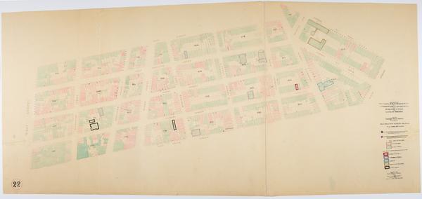
Still Image Map showing over-crowding of the buildings on the lots and the consequent lack of light and air space also strong-holds of poverty and agencies for betterment in the tenement house district bounded by West Street, West Broadway, W. Houston, Spring Streets Scale [ca. 1:650]. View Item
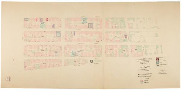
Still Image Map showing over-crowding of the buildings on the lots and the consequent lack of light and air space also strong-holds of poverty and agencies for betterment in the tenement house district bounded by 22nd Street, 17th Street, 11th Avenue, 6th Avenue / pr Scale [ca. 1:650]. View Item
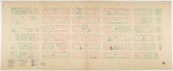
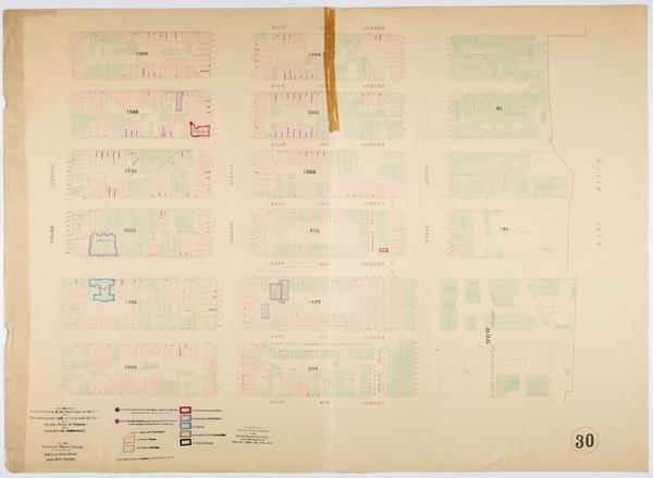
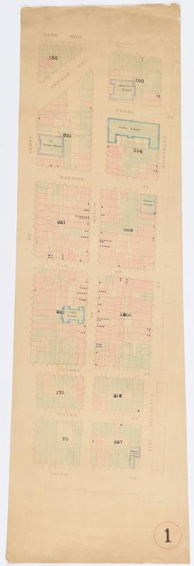
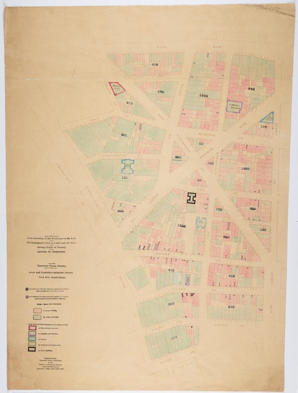
Still Image Map showing over-crowding of the buildings on the lots and the consequent lack of light and air space also strong-holds of poverty and agencies for betterment in the tenement house district bounded by Dover and Frankfort, Catharine Streets, Park Row, Sout Scale [ca. 1:650]. View Item
Still Image Map showing over-crowding of the buildings on the lots and the consequent lack of light and air space also strong-holds of poverty and agencies for betterment in the tenement house district bounded by Dover and Frankfort, Catharine Streets, Park Row, Sout Scale [ca. 1:650]. View Item
Name 136556-Service File File 136556-original-file.jp2 (10.13 MB) MIME type image/jp2 Media Use Service File Media of Map showing over-crowding of the buildings on the lots and the consequent lack of light and air space also strong-holds of poverty and agencies for betterment in the tenement house district bounded by Dover and Frankfort, Catharine Streets, Park Row, Sout File size 10626195 Still Image 2 Items Map showing over-crowding of the buildings on the lots and the consequent lack of light and air space also strong-holds of poverty and agencies for betterment in the tenement house district bounded by Dover and Frankfort, Catharine Streets, Park Row, Sout Scale [ca. 1:650]. View Item
Name 136556-Service File File 136556-original-file.jp2 (10.13 MB) MIME type image/jp2 Media Use Service File Media of Map showing over-crowding of the buildings on the lots and the consequent lack of light and air space also strong-holds of poverty and agencies for betterment in the tenement house district bounded by Dover and Frankfort, Catharine Streets, Park Row, Sout File size 10626195